
Air transportation safety investigation report A20P0060
Collision with power line, missing aircraft
International Flight Centre Inc.
Cessna 172M, CF-CCV
Abbotsford Airport, British Columbia, 9.7 NM NNW
The Transportation Safety Board of Canada (TSB) investigated this occurrence for the purpose of advancing transportation safety. It is not the function of the Board to assign fault or determine civil or criminal liability. This report is not created for use in the context of legal, disciplinary or other proceedings. See Ownership and use of content.
History of the flight
On 06 June 2020, the International Flight Centre Inc. Cessna 172M aircraft (registration CF-CCV, serial number 17261135) was conducting a visual flight rules (VFR) training flight from Vancouver/Boundary Bay Airport (CZBB), British Columbia (BC), with 1 student and 1 instructor on board.
At 1257,Footnote 1 the aircraft departed CZBB and turned east-northeast while climbing to an altitude of 2400 feet above sea level (ASL).
At 1304, the instructor contacted the tower controller at Pitt Meadows Airport (CYPK), BC, for permission to enter the control zone for circuits. The CYPK tower controller responded that additional aircraft could not be accommodated in the circuit and the pilot should try Langley Regional Airport (CYNJ), BC, as an alternate. At 1305, the instructor contacted the CYNJ tower controller to request transit through the CYNJ control zone, and was cleared as requested. There were no further communications received from the aircraft.
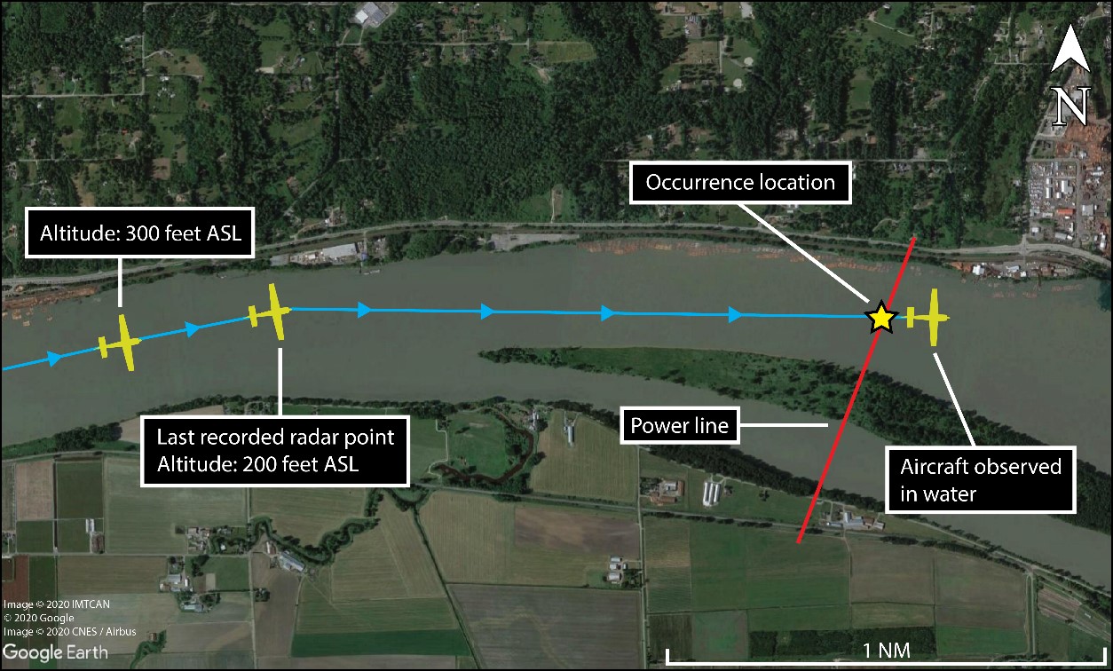
At 1309, the aircraft began a descent from 2200 feet ASL, flying over the Fraser River near Fort Langley Water Aerodrome (CAS4), BC, levelling briefly at 1500 feet ASL and 300 feet ASL before it levelled at 200 feet ASL over the river when radar contact was lost at 1312:29. The aircraft’s last recorded position was approximately 9.7 nautical miles (NM) north-northwest of Abbotsford Airport (CYXX), BC, travelling eastbound at 200 feet ASL, with a groundspeed of 80 knots. At approximately 1313, the aircraft flew into a power transmission line that was strung across the Fraser River, approximately 125 feet above the water (Figure 1).
Observers in the area reported seeing a low-flying aircraft, and then seeing a splash in the river. They then saw the aircraft partially submerged. The first 911 call was received at 1319.
When local RCMP (Royal Canadian Mounted Police) and emergency responders arrived on scene, the aircraft could no longer be seen. Over the next several months, the RCMP used boats, helicopters, divers, and underwater imaging equipment in an attempt to locate the aircraft. However, the water level in the river was high at the time of the occurrence, which hampered the first few months of the search.
At the time of report writing, the occurrence aircraft and the occupants have not been found.
Weather information
According to the aerodrome routine meteorological report issued at 1300 for CYXX, the closest aerodrome to the site of the occurrence, the weather was favourable for VFR flight, with a reported temperature and dew point of 15 °C and 7 °C respectively. In addition, images recorded by Drive BCFootnote 2 road cameras near the occurrence site did not indicate the presence of any precipitation, low cloud, or reductions in visibility around the time of the occurrence. Weather was not considered a factor in this occurrence.
Pilot information
Instructor
The instructor was licensed and rated to provide flight instruction. He held a Class 4 instructor rating, and was therefore required to be under the supervision of a Class 1 or 2 instructor.Footnote 3 In this case, the instructor was being supervised by the flight training unit’s (FTU’s) chief flight instructor, a Class 2 instructor. The occurrence instructor had accumulated a total of approximately 808 flight hours, including 494 hours as an instructor.
Student
The investigation determined that the student had accumulated approximately 80 flight hours at an FTU in the United States. The training at that FTU had concluded in May 2019. The student’s flight instruction in Canada began in February 2020, and he had accumulated approximately 10 additional flight hours at the time of the occurrence.
Aircraft information
The occurrence aircraft was manufactured in 1972 and had accumulated approximately 3407 hours of total airtime. Records indicate that the aircraft was certified, equipped, and maintained in accordance with existing regulations. The aircraft had no known deficiencies before the occurrence flight.
The aircraft was not equipped with a flight data or cockpit voice recorder, nor was it required to be by regulation.
The aircraft was equipped with an ACK Technologies emergency locator transmitter, model E-04, capable of transmitting on 121.5 MHz and 406 MHz. No signal was detected.
Power transmission lines and markings
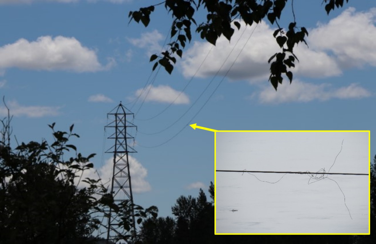
At the occurrence site, there are two 69 kilovolt (kV) power transmission circuits, consisting of 3 phase conductors each, for a total of 6 conductors (power transmission lines),Footnote 4 spanning the Fraser river. These lines are owned by BC HydroFootnote 5 and are approximately 10 feet apart vertically and 22 feet apart horizontally. Three suspension towers support the power transmission lines that span across the river (Table 1).
| Name of tower | Height above sea level | Height above ground level |
|---|---|---|
| North suspension tower | 84 m (276 feet) | 57 m (187 feet) |
| Middle suspension tower | 63 m (207 feet) | 57 m (187 feet) |
| South suspension tower | 50 m (164 feet) | 44 m (144 feet) |
The aircraft collided with the span between the North and the Middle suspension towers, which is 2077 feet long and was approximately 125 feet above the river at the time of the occurrence.Footnote 6 The lowest line was damaged and was disabled by circuit protection (Figure 2).
Section 601.23 of the Canadian Aviation Regulations (CARs) states that
[…] any building, structure or object, including any addition to it, constitutes an obstacle to air navigation if [...] in the case of any catenary wires crossing over a river, any portion of the wires or supporting structures is higher than 90 m [about 300 feet] AGL.Footnote 7,Footnote 8
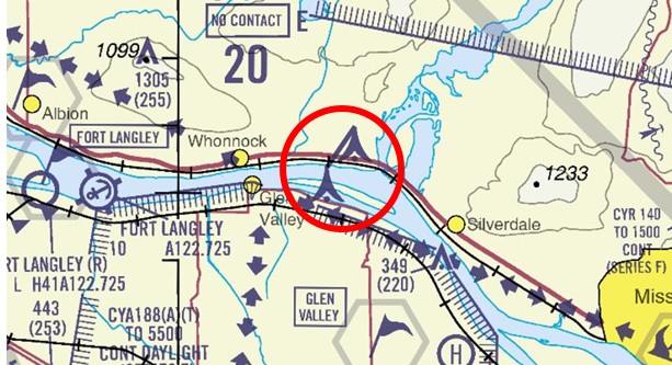
Therefore, given their height above the water, the power transmission lines did not constitute an obstacle to air navigation according to that regulation; however at an undetermined date prior to 2008, Transport Canada (TC) deemed the crossing to be an obstacle to navigation as the power lines were in close proximity to the VFR route through the Glen Valley practice area. As a result of this determination, lights were installed on the suspension towers, and the power transmission lines were depicted on the VFR navigational chart for the area (Figure 3).
In October 2015, BC Hydro submitted a request to TC to upgrade the suspension tower lights. TC approved the request shortly after the submission.
Medium-intensity (CL-866) white lights for daytime use were installed on the North and Middle suspension tower in 2019; however, at the time of the occurrence, the lights had not been activated.
As a result of the inactive suspension tower lighting, a recurring NOTAM was issued in 2015, indicating that the cable crossing was unmarked. This NOTAM was still valid at the time of occurrence. The investigation was unable to determine if the flight instructor or student were aware of the NOTAM, or if they were aware that the power transmission lines were indicated on the navigational chart.
Obstacle collision avoidance system
In 2008, BC Hydro implemented an obstacle collision avoidance system (OCAS) on spans of power transmission lines along known aviation routes as a trial at 4 sites in the province, including the occurrence site. The system used active radar, radio communication, and strobe lights to warn aircraft if they were on a collision course with the monitored span. Because the system used radar, its operation was independent of any equipment on board the aircraft.
In 2014, the private company that was supplying BC Hydro with support for the OCAS equipment ceased operation. Because OCAS relied on the real-time monitoring that the company provided, when this ended, BC Hydro was forced to stop using the system and all 4 OCAS in the province were deactivated. At the time, there were no other certified alternatives.
Low flight
The CARs stipulate that no person shall operate an aircraft “at a distance less than 500 feet from any person, vessel, vehicle or structure.”Footnote 9 This distance of 500 feet applies both vertically and horizontally. The CARs do allow for flight training aircraft to operate below 500 feet, but only when operated outside of a built-up area, when operated without creating a hazard to persons or property on the surface, and when operated for the purpose of flight training by or under the supervision of a qualified flight instructor.Footnote 10 The Transport Canada Aeronautical Information ManualFootnote 11 provides good airmanship advice on low flying.
Intentionally flying at a low altitude increases the risk of an accident. At heights below 90 m (about 300 feet) AGL, obstacles can be difficult to see as they might not be physically marked, or indicated on navigational charts. Flying at low altitude also reduces the margin of safety in the event of engine failure, a loss of control, or any other unexpected circumstances, and increases the risk of an impact with the ground or an obstacle.
The TSB has recently investigated several occurrencesFootnote 12 which involved intentional low flight.
International Flight Centre Inc. training program
Flight training at International Flight Centre Inc. was being conducted with reference to the lesson plans contained in TC’s Flight Instructor Guide – Aeroplane (TP 975). The instructor was conducting flight training, for the student, in accordance with the regulations for initial issuance of a licence.Footnote 13
The flight training program outline provided to the student did not contain a policy on acceptable minimum altitudes for low-level flying activity, nor was it required under the CARs. The Chief Flight Instructor had, however, verbally directed his instructors to not go below 500 feet during flight instruction. A review of the student pilot’s training record provided no indication that low-level manoeuvers had been previously practised (e.g., precautionary landings, low level diversions), or that such manoeuvres were planned for the occurrence flight. The investigation was unable to determine what, if any, purpose there was to operate the aircraft at less than 500 feet above the Fraser River.
Safety action taken
BC Hydro has prioritized the schedule for the commissioning of the daytime strobe lights, which should be completed in 2021. Once this work has been completed, the NOTAM will be rescinded.
Safety message
Low-altitude flight always presents higher risk. Not all hazards, such as power transmission lines, are physically marked or can be seen in time to avoid collision.
This report concludes the Transportation Safety Board of Canada’s investigation into this occurrence. The Board authorized the release of this report on . It was officially released on .