Collision with terrain following night-time takeoff
Robinson R44 Raven II (Helicopter) C-GEBY
Saint-Ferdinand, Quebec
The Transportation Safety Board of Canada (TSB) investigated this occurrence for the purpose of advancing transportation safety. It is not the function of the Board to assign fault or determine civil or criminal liability. This report is not created for use in the context of legal, disciplinary or other proceedings. See Ownership and use of content. Masculine pronouns and position titles may be used to signify all genders to comply with the Canadian Transportation Accident Investigation and Safety Board Act (S.C. 1989, c. 3).
Summary
At approximately 2100 Eastern Daylight Time, the Robinson R44 Raven II (registration C‑GEBY, serial number 11505), a privately-owned helicopter, departed from the Saint‑Ferdinand Aerodrome, Quebec, with the pilot and 3 passengers on board for a night flight to Saint-Nicolas, Quebec, under visual flight rules. At 2109, a distress signal emitted by the emergency locator transmitter was detected by the SARSAT (search and rescue satellite-aided tracking) system. The aircraft was found approximately 2 hours and 35 minutes later in a wooded area, about 3940 feet from its point of departure. The helicopter was destroyed on impact, but did not catch fire. All of the occupants perished in the crash.
Factual information
History of the flight
Earlier on the day of the occurrence flight, 27 August 2011, the pilot and 3 family members had departed from the pilot’s home in Saint-Nicolas, Quebec, to visit friends in the Saint‑Ferdinand, Quebec, area. The main tank had been filled with 46 litres Footnote 1 of 100LL fuel. Because the point of departure was within the control area of the Québec City Jean-Lesage International Airport (CYQB), the pilot had called the control tower before take-off, at around 1809. Footnote 2 The pilot had obtained the wind direction, wind speed, and altimeter setting. No flight plan had been filed with the Quebec flight information centre, nor was a flight itinerary filed with a person responsible. The aircraft had taken off at about 1813, and the pilot had been authorized immediately to switch to enroute frequency once out of the control zone. The aircraft had continued its flight at an altitude of 1500 feet above sea level (asl). It had left radar coverage at 1838, 0.25 nautical miles (nm) east of the Saint-Ferdinand Aerodrome at an altitude of 1500 feet asl. Footnote 3 The aircraft had landed without incident in the field south of the threshold of Runway 05, where it remained until its departure on the occurrence flight.
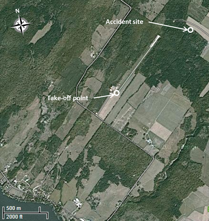
Around 2050, the pilot and 3 passengers returned to the helicopter for the night flight home, a distance of 37 nm that would have taken approximately 20 minutes to cover. The aircraft did not appear on the radar after take-off. No one saw the aircraft take off or crash. Only a sound of impact was heard, around 2100. At 2109, a distress signal from the aircraft’s emergency locator transmitter (ELT) was detected by the Cospas-Sarsat satellite system. Footnote 4 At 2344, the aircraft was found by a Sûreté du Québec officer in a wooded area about 3940 feet northeast of the take-off point, just 1215 feet from the far end of Runway 05 (figure 1).
All those on board perished in the crash. The 2 rear passengers and the front passenger seated on the left were found strapped to their seats, while the pilot had been ejected from the front right seat. Due to the damage and the operational condition of the pilot’s seat restraint system, it was not possible to determine whether the pilot was wearing a safety harness.
Injuries to persons
| Injuries | Crew | Passengers | Others | Total |
|---|---|---|---|---|
| Fatal | 1 | 3 | − | 4 |
| Serious | − | − | − | − |
| Light/none | − | − | − | − |
| Total | 1 | 3 | 4 |
Damage to aircraft
The aircraft did not catch fire, and all of the damage stemmed from the impact. The front of the aircraft was completely destroyed. The instrument panel and flight controls were severely damaged. The rear seats were still attached to the floor and to the engine-compartment firewall. The main shaft and rotor head were still attached to the engine, which exhibited very little visible damage. The main-rotor blades had broken off on impact. Only a small piece of the blades remained attached to the main-rotor head. Although broken, the tail boom was partially attached to the fuselage. The damage to the main- and tail-rotor blades was consistent with object impact during rotation under power.
Other damage
The crash damaged a number of trees, and approximately 125 litres of fuel Footnote 5 spilled on the ground.
Personnel information
The pilot held a private pilot licence (helicopter) since 2005 with a valid Category 3 medical certificate. The pilot had trained on an R44, and in December 2006, received a night rating. The pilot’s logbook showed, as of 26 August 2011, a total of 879.7 hours of flight time on helicopters, including 10.6 hours of simulated instrument time. As of that date, the pilot had also logged night-flight time of 13 hours dual and 46.8 hours solo.
In the last 6 months, the pilot had logged 6 hours of night-flight time as pilot in command, for a total of 9 take-offs/landings, which satisfied the recency requirements stipulated in the Canadian Aviation Regulations (CARs). Footnote 6 All of these take-offs took place in areas where the surrounding environment was illuminated. The pilot had also complied with the requirement to successfully complete a recurrent training program in accordance with the personnel licensing standards, Footnote 7 by taking a flight with an instructor during the preceding 24 months.
The front passenger, sitting on the left, held a helicopter student pilot permit that had been issued on 15 July 2011. It is unlikely that the front passenger was flying the aircraft at the time of the accident, because this individual had never received instruction in left-seat flying. This passenger also had no night-flight experience, and the pilot on the right was not qualified to instruct or supervise a student pilot flying.
Aircraft information
General
| Manufacturer | Robinson Helicopter Company |
|---|---|
| Type and model | Robinson R44 Raven II |
| Year of manufacture | 2006 |
| Serial number | 11505 |
| Certificate of airworthiness | Valid |
| Total airframe time | 594.9 |
| Engine type | Avco Lycoming IO-540-AE1A5 |
| Maximum allowable take-off weight | 2500 pounds |
| Recommended fuel type(s) | 100LL |
| Fuel type used | 100LL |
C-GEBY had been imported into Canada in 2007. The aircraft was privately owned by 9049‑5854 Québec Inc., of which the pilot was a shareholder, and had been purchased by the company in May 2011. At the time of purchase, it bore the aircraft registration C-FFSM, which was changed to C-GEBY on 30 May 2011.
Records show that the helicopter was certified, equipped, and maintained in accordance with current regulations. The aircraft was equipped for night flight in accordance with Part 605.16 of the CARs. The helicopter did not have a cockpit voice recorder or a flight data recorder, neither of which is required by regulation.
On 26 August 2011, the helicopter had accumulated 594.9 hours of flight time since it was manufactured. It had flown 29.2 hours since its last 50-hour inspection, which was on 16 August 2011. The aircraft’s weight and centre of gravity were within limits.
On 10 November 2011, Robinson Helicopter Company produced its 10 000th helicopter. Slightly more than half of the aircraft are R44s. According to Canadian Civil Aircraft Register information dated 16 July 2012, there are 406 such R44s in operation in the country, of which 241 are in private operation. Of this number, 104 are based in Quebec. Footnote 8
Emergency locator transmitter
The aircraft was equipped with a Kannad 406 AF model ELT transmitting on 121.5 megahertz (MHz) and 406 MHz. The ELT activated on impact, and was not damaged in the accident. It remained in its bracket, and its antenna remained attached.
When activated, the ELT emits a distress signal to the Cospas‑Sarsat system, which consists of a constellation of LEOSAR Footnote 9 (LEO) and GEOSAR Footnote 10 (GEO) satellites. These satellites process and relay the 406-MHz signal to ground stations, where the location of the ELT is pinpointed with an accuracy of within 2 nm. Footnote 11 This type of ELT is also programmed to transmit, 50 seconds after an impact, a coded message that allows the Canadian Mission Control Centre (CMCC) to access the information that was provided when the ELT was registered, including the aircraft identification and the person or organization responsible for the aircraft. This message is normally received on 406 MHz by one of the GEO satellites. In this occurrence, none of the GEOs detected the signal. Footnote 12 However, the LEO captured the coded message on the 406-MHz frequency at 2109, and the calculated position Footnote 13 was relayed to the Joint Rescue Coordination Centre (JRCC), which is responsible for coordinating all search-and-rescue (SAR) operations associated with aircraft and marine emergencies. The Sûreté du Québec was informed of the calculated position of the crash at 2241.
A Canadian Forces C-130 Hercules aircraft was dispatched from Trenton, Ontario, to the accident site at 2346 that evening, and arrived at the calculated position at 0042 (28 August). A Griffon helicopter was also dispatched to the site, but turned back once the wreckage and its occupants were located by the Sûreté du Québec at 2344, approximately 2 hours 35 minutes after the crash.
Emergency locator transmitter registration
According to subsection 605.38(4) of the CARs, an ELT broadcasting on the 406-MHz frequency must be registered on the Canadian Beacon Registry of the National Search and Rescue Secretariat. The Canadian registration system maintains the Canadian Beacon Registry (Registry), which stores information about personal location beacons, emergency position-indicating radio beacons (EPIRBs) and ELTs. Online access to the Registry is available to all 406-MHz emergency beacon owners to register new emergency beacons or to update their current information. The information contained in the Registry includes the owner's name, aircraft details, and emergency contact information. The SAR authorities cross-reference the emergency beacon identifier (ID) with the Registry, and with a single phone call, can determine whether the distress signal is a false alert or collect additional details to respond more effectively to the incident. Emergency beacon information can be added or updated online, or by faxing or emailing a completed registration form.
Every emergency beacon contains a unique ID and country code. Features, combined with the registration of the unit with the Registry, provide important information to search-and-rescue authorities in the event of a distress situation. In this occurrence, the information in the Register had not been updated by the new owner after the acquisition and change in registration of the aircraft in May 2011. When the ELT activated following impact, the information received by the CMCC therefore referred its staff to the aircraft's former owner and registration, which caused a 27-minute delay in reaching someone who might know where the aircraft was.
The aviation industry only recently switched to 406-MHz ELTs. The CMCC indicates that it is common for the information in the Registry not to be updated after a change of ownership or registration. In this occurrence, the ownership and registration of the helicopter had recently changed, enabling the CMCC to locate the contact information of the new owner within a reasonable period of time. However, this is not always the case, and the former owner is not always able to provide the new owner's contact information. In such a case, the additional research required to find the information could delay deployment of SAR services.
Meteorological information
On the evening of the accident, the southeast part of Quebec was under a ridge of high pressure with generally light winds, and scattered altocumulus and cirrus clouds, due to the approach of post-tropical storm Irene. Located in the eastern United States at 2100, this storm did not begin to affect southeastern Quebec significantly until around 0700 the next day, when moderate rain was reported in Sherbrooke, Quebec.
As well, between 2000 and 2300, towering cumulus (TCU) and cumulonimbus (CB) clouds were observed near the Saint Lawrence Valley and Québec City, bringing light rain and isolated thunderstorms. Satellite and radar images do not show TCU and CB clouds near Saint-Ferdinand and Sherbrooke.
No significant icing and turbulence conditions were observed or forecast, other than the possibility of moderate to severe icing at over 10 000 feet asl in the TCU and CB clouds observed in the radar and satellite images near Québec City.
No aviation routine weather report (METAR) was issued for the Saint-Ferdinand Aerodrome. The 2 closest aerodromes that issue METARs are CYQB and the Sherbrooke Aerodrome (CYSC), located 40 and 42 nm, respectively, from Saint-Ferdinand. The 2100 METARs for CYQB and CYSC were as follows:
- CYQB at 2100: wind from 230° True (T) at 2 knots, visibility 8 statute miles (sm) in light rain, a few clouds at 2500 feet above ground level (agl), overcast at 5300 feet agl, temperature 20°C, dew point 17°C, altimeter setting 29.90 inches of mercury (in. Hg).
- CYSC at 2100: calm wind, visibility 9 sm, scattered clouds at 13 000 feet agl, temperature 16°C, dew point 15°C, altimeter setting 29.91 in. Hg.
Sunset was at 1934. Footnote 14 The end of evening civil twilight was at 2007. The azimuth of the waning moon was approximately 321° and was 25° below the horizon, with only 3% of its disc lit. The moon was therefore not visible at the time of take-off. According to the information collected, it was very dark.
Aids to navigation
Not applicable.
Communications
The designated aerodrome traffic frequency (ATF) for the Saint-Ferdinand Aerodrome is 123.2 MHz. Communications transmitted on this frequency are not recorded and are not required to be. Consequently, it could not be determined whether the communications procedures for uncontrolled aerodromes with an ATF area Footnote 15 were followed. No one in the area who might have been on this frequency heard any transmission from the pilot. No distress message from C-GEBY was heard or recorded on the 121.5-MHz emergency frequency.
Aerodrome information
The elevation of the Saint-Ferdinand Aerodrome is 1050 feet asl. Runway 05/23 was an unlit Footnote 16 3000‑foot long by 75-foot wide grass/gravel runway. Beyond the end of Runway 05 is a wooded area; however, the end of Runway 23 abuts on an unobstructed field of almost 1400 feet that slopes toward a lake. The aerodrome has no aircraft rescue and firefighting (ARFF) services, nor are they required by regulation.
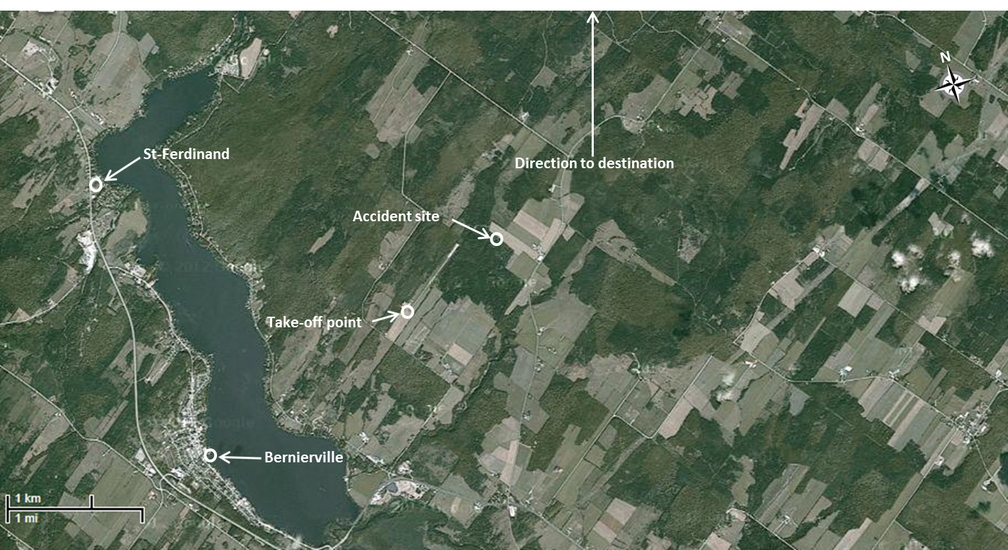
Apart from the village of Bernierville, situated approximately 1.7 nm southwest of the airport, and the village of Saint-Ferdinand, approximately 2 nm west, there are few visual references at night (Appendix B). Although there are a few hangars on the southwest side of the runway, none are lit. The roads next to the airport are not lit either, and there are few homes in the vicinity. Moreover, there are many trees in the area north-northeast of the airport (the direction of the planned destination).
The traffic circuit is the path that aircraft must follow at aerodromes. A standard circuit is used at Saint-Ferdinand, meaning that all turns are made to the left. Aircraft departing the circuit or taking off must climb straight ahead on the runway heading until reaching the circuit traffic altitude before commencing a turn in any direction to their enroute heading. Turns back toward the circuit must not be initiated until at least 500 feet agl.
There is no indication that the pilot had previously flown in or out of the Saint-Ferdinand Aerodrome, whether during the day or at night.
Flight recorders
Not applicable.
Wreckage and impact information
General
The tree damage indicates that the angle of impact was about 40° downward on a track of 350° magnetic at an undetermined speed. The aircraft slid horizontally no more than 250 feet before coming to rest. The tail rotor, main-tank cap, skids and pieces of plastic from the windshield and side window, as well as the door panels, were found at the beginning of the path of the impact.
The forward fuselage containing the 2 front seats, the controls and the severed instrument panel was found some 230 feet from the initial point of impact with the trees. The aft fuselage containing the 2 rear seats, the fuel tanks, the main-rotor gearbox, the engine and tail boom came to rest on the left side, in the opposite direction of the path of the impact, about 20 feet from the forward fuselage.
Flight controls failed in overload on impact with the ground, and their continuity could not be confirmed. The Telatemp strip Footnote 17 affixed to the transmission freewheeling unit Footnote 18 showed no signs of discolouration, therefore eliminating the possibility of a freewheeling unit malfunction before the accident.
The main fuel tank was cracked, causing approximately 125 litres of fuel to spill. The auxiliary tank contained a small amount of fuel, which was recovered and verified. It contained no water or contaminant, and its colour confirmed that it was the appropriate fuel for the aircraft engine (100LL).
Wreckage examination
The wreckage was moved to the Transportation Safety Board (TSB) Laboratory for examination. All of the recovered instrumentation was examined (Appendix C). Except for the airspeed indicator, all of the instruments exhibited impact damage.
An examination of the engine and its accessories revealed no anomalies that could have affected engine operation. To corroborate the findings of the engine examination, the bulbs of the warning lights were examined to determine whether the lights had come on, requiring the pilot's attention.
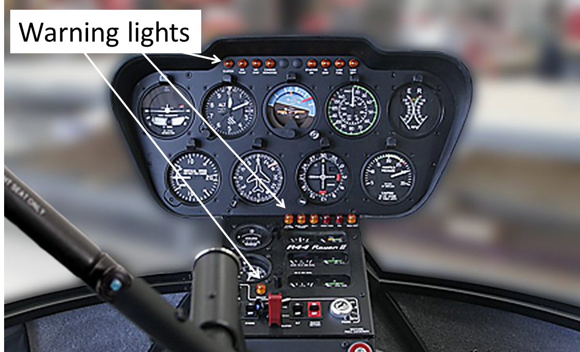
The R44 Raven II is equipped with 15 warning lights that warn the pilot of conditions requiring attention. Eight of these lights are located at the top of the instrument panel, and 7 are in the middle panel (Photo 1). Footnote 19
Typically, a bulb filament will stretch if it is hot or illuminated at the time of impact. A filament can also fracture sharply when cold or not change at all. Except for the filament in the CLUTCH warning light, which stretched slightly, none of the filaments in the bulbs that resisted the impact showed evidence of fracture or stretching (Appendix D).
Despite the unclear condition of some of the warning lights, other factors indicate that they were probably off. For instance, it is unlikely that the LOW FUEL light came on, considering the amount of fuel loaded before departure from Saint-Nicolas and the actual flight time. As well, an inspection of the components of the FUEL FILTER, AUX FUEL PUMP, ALT, OIL PRESSURE, and GOVERNOR OFF lights revealed no anomaly that would have caused these lights to come on. The ENGINE FIRE light was very likely off, because there was no indication of a fire either before or after impact. Concerning the CLUTCH light, which may have been on at the time of impact, the Pilot's Operating Handbook states that it is normal for this light to sometimes come on briefly.
Clutch system
Engine power is transmitted to the main rotor through a belt system, with the engine and transmission engaged by progressive tensioning of the belts. After engine start-up, the belts are tensioned by an actuator motor that automatically stops at a pre-set value. An amber CLUTCH warning light located on the instrument panel comes on when the actuator is running (i.e., when the belts are being tensioned or are no longer tensioned). Footnote 20
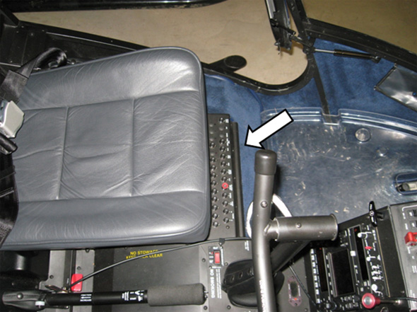
As previously mentioned, it is normal for the warning light to come on during flight. However, if it remains on for more than 7 or 8 seconds, the Pilot's Operating Handbook recommends pulling the clutch circuit breaker, reducing power, and landing immediately. The breaker panel, located on the floor in front of the left-hand seat, is difficult to see from the pilot's seat (Photo 2). For this reason, it is marked with a red ring to facilitate identification and manual activation. As well, the pilot is warned to be prepared to enter autorotation and to inspect the drive system. Following the accident, the breaker was found “IN”, and was working properly.
Examination of global positioning system
The helicopter was equipped with a portable Garmin GPSMAP696 global positioning system (GPS) and a GPSMAP60Cx. However, examination of them showed that neither system was working after the accident. The TSB could not obtain the technology to extract and translate the data contained in the non-volatile memory of these GPS systems.
The GPSMAP696 has a 7-inch video graphics array (VGA) colour display. When in autolocate mode, the system collects satellite data and establishes the aircraft’s current location. This process can take up to 5 minutes. With the GPS696, backlight intensity can be adjusted from 0 to 10. Footnote 21 The tests conducted by the TSB on a GPS695 Footnote 22 showed that the range of backlight intensity in the Garmin GPSMAP696 is such that it can function even in very dark conditions.
The TSB asked Garmin’s help to extract and translate the data. The company said that it regularly receives requests for support in cases where the data are not needed to determine the cause of an accident, or are linked to an incident, or in many cases, are simply to confirm facts that are already known (such as radar data). Moreover, the data in the non-volatile memory vary with the model. According to Garmin, its ability to contribute to accident investigations is often limited. In such cases, the company usually decides not to get involved.
Medical and pathological information
There was no indication that the pilot's performance was hampered by physiological factors.
Fire
The combustible material of greatest significance in small-aircraft accidents is uncontained fuel. Although fuel spilled, there was no fire on impact. The aircraft's battery was found about 20 feet from the engine compartment, and the fuel tanks and electrical connections were broken by the impact.
Survival aspects
The occupants had little chance of survival, as the cabin was destroyed when the aircraft crashed into the trees.
Tests and research
Not applicable.
Organizational and management information
Not applicable.
Additional information
Night flying
Night flying involves numerous risks due to poor visual cues, especially on take-off and landing. The fact that there are few or no visual references at night can lead to various illusions causing spatial disorientation.
Night flying in or out of featureless terrain, such as bodies of water or wooded terrain, is difficult. These areas are referred to as black holes. When moving from bright light to darkness, the eye needs time to adjust, which can affect night vision. To facilitate this process, pilots are advised to keep cockpit lights turned low, so that their eyes stay adjusted to darkness and so that they can see clearly outside the aircraft. Footnote 23 In addition, instrument or cabin lights can bounce off the windshield and lead the pilot to mistake them for something else.
In this accident, the investigation could not determine the light intensity in the cockpit. Moreover, since the GPSMAP696 was not working after the accident, the TSB could not determine the intensity of the GPS's backlight, or how the light or its reflection off the windshield affected the pilot's night vision.
Two safety notices issued by Robinson Helicopter Company, SN-18 and SN-26, make reference to the dangers and risk pilots face when flying helicopters at night. While both notices also make reference to poor visibility at night, SN-26 stipulates that one should never fly at night unless one has clear weather with unlimited or very high ceilings, and plenty of celestial or ground lights for reference. Furthermore, the Pilot's Operating Handbook indicates that “VFR [i.e., visual flight rules] operation at night is permitted only when landing, navigation, instrument, and anti-collision lights are operational.” Footnote 24
Night-flight training
To obtain a night rating after receiving a private pilot licence (helicopter), an applicant shall have acquired a minimum of 20 hours of pilot flight time in helicopters, which shall include:
- 10 hours of night flight time, including a minimum of:
- 5 hours of dual flight time, including 2 hours of cross-country flight time;
- 5 hours of solo flight time, including 10 take-offs, circuits and landings;
- 10 hours of dual-instrument time. Footnote 25
Therefore, a pilot may obtain a night rating after having completed only 10 hours of actual night flight time. An additional 5 hours may be done in a flight simulator, and 5 hours of dual-instrument time may be completed in flight under a hood during daytime hours.
Flight training schools are often located near populated areas; training is therefore conducted in and around cities or towns where the surrounding environment is illuminated. Take-offs and landings are usually executed from lit runways or heliports. Night-rated pilots of fixed-wing aircraft will usually travel from one airport or aerodrome to another, always taking off from and landing on lit runways with varying lighting systems and approach path aids, such as visual approach slope indicator system (VASIS).
Current regulatory requirements for night-rating training are the same for private helicopter pilots as they are for fixed-wing aircraft pilots. The environment in which the night-rated helicopter pilot may choose to fly can vary greatly, due to the versatility of the aircraft and the environment in which helicopter operations take place.
A search of the Transport Canada database showed that, in 1988, there were 210 licensed private helicopter pilots in Canada. This number increased to 331 in 1998, 596 in 2008, and 637 in June 2011. Footnote 26 Quebec has the largest number of private-helicopter pilots (259), compared with 124 in Ontario, 110 in British Columbia, 77 in Alberta, 12 in Manitoba, 9 in Nova Scotia, 5 in Saskatchewan, and 2 in New Brunswick.
Canada currently has 120 night-rated private helicopter pilots, including 73 in Quebec.
The TSB database shows that, in the 10-year period from 1 January 2002 to 31 December 2011, there were 63 private-helicopter accidents in the country, of which 28 were in Quebec. Of the total number of accidents, 22 involved Robinson R44 helicopters, and 7 of these were fatal. Of the 22 accidents involving R44 helicopters, only 1 Footnote 27 involved a mechanical problem. During the same period, 5 of the 6 accidents that occurred at night happened in Quebec, and 4 involved the R44, including the incident in question. Mechanical failure was not the cause of any of these crashes.
Spatial disorientation
According to the Federal Aviation Administration (FAA) document Medical Facts for Pilots (AM-400-03/1), spatial orientation is
our natural ability to maintain our body orientation and/or posture in relation to the surrounding environment (physical space) at rest and during motion. Genetically speaking, humans are designed to maintain spatial orientation on the ground. The three-dimensional environment of flight is unfamiliar to the human body, creating sensory conflicts and illusions that make spatial orientation difficult, and sometimes impossible to achieve. Statistics show that between 5 to 10% of all general aviation accidents can be attributed to spatial disorientation, 90% of which are fatal. Footnote 28
Of the 3 sensory systems, Footnote 29 the visual system is the most important, providing 80% of the information we need to maintain equilibrium and orientation. Consequently, in the absence of visual cues, 80% of our orientation information is lost, leaving only 20% split equally between the vestibular system Footnote 30 and the proprioceptive system. Footnote 31 Both are less accurate than the visual system, and are prone to illusions and interpretation errors.
There are various types of illusions that can affect a pilot's orientation, including vestibular illusions. Vestibular illusions are the most complex and the most dangerous. The vestibular system inside the inner ear is made up of 2 otolith organs, Footnote 32 which are sensitive to linear acceleration, and the semicircular canals, which are sensitive to angular acceleration.
In the case of linear acceleration, the somatogravic illusion frequently occurs after take-off, when, in the absence of visual cues, the pilot incorrectly perceives the aircraft to be pitching nose up. The pilot may respond by excessively lowering the nose of the aircraft. Conversely, a deceleration is perceived as the aircraft is pitching nose down.
Angular acceleration occurs during turns. There are 3 semi-circular canals in each ear, which operate in each of the primary axes of motion (i.e., pitch, roll, and yaw). Any movement of fluid in the canals is interpreted as a rotation. When the pilot begins a turn, the fluid in the canals moves and informs the pilot that a turn has been started. Once the turn is completed and the aircraft is levelled, the fluid inside the canals will continue to move because of inertia, and the pilot will have the impression of turning in the opposite direction for about 10 to 20 seconds.
According to Section 2 of the Handbook for Civil Aviation Medical Examiners (TP13312E), “the most extreme form of vestibular disorientation is due to the Coreolis phenomenon. This is thought to be caused when two different semi-circular canals are stimulated at the same time.” Footnote 33 The phenomenon can happen when the pilot's head is turned to the front or to the back while the aircraft is turning. It can happen if the pilot's head is turned to the front to perform a task, or raised to look ahead. This movement can create the sensation of pitch, roll, and yaw at the same time, making it difficult for the pilot to control the aircraft. “Even if control of the aircraft can be maintained under these … circumstances, the pilot may still be subject to the leans or other abnormal sensations until able to obtain a visual reference.” Footnote 34
Any pilot can feel spatially disoriented, but this does not necessarily mean that the pilot will lose control of the aircraft. There are various preventive measures to minimize the risk of spatial disorientation, and, if it does occur, to minimize the risk of an accident. Most of these measures can be taken before take-off. Footnote 35 For example, fatigue, stress, a cold, alcohol consumption, and some medications can increase susceptibility to spatial disorientation. Being aware that disorientation can occur during a flight is one of the best ways to prevent loss of control while in the air.
Analysis
General
The pilot had the necessary licence and qualifications to fly the aircraft, and there is no evidence that the pilot's capacities were diminished by physiological factors. There is nothing to indicate that fatigue, weather conditions, or the airworthiness of the aircraft played a role in this accident. Consequently, this analysis will focus on plausible scenarios that could have caused the crash, and on the risks associated with night flight.
Plausible scenarios
Given that it was night and that the aerodrome was not equipped with a lighting system, take-off was not allowed under the Canadian Aviation Regulations (CARs). It is not known why the pilot would have chosen to fly knowing that the aerodrome did not have a lighting system; however, the following may have influenced the pilot's decision:
- The occupants of the aircraft had planned to return home the same day.
- The weather conditions were conducive to visual flight.
- It was a short flight.
- The approach of post-tropical storm Irene would have affected flight conditions the next day.
In the absence of eye witnesses, radar data, and global positioning system (GPS) data, the take-off path could not be determined. However, it is reasonable to believe that the aircraft crashed shortly after take-off. The occupants arrived at the aerodrome around 2050, and the first emergency locator transmitter (ELT) signal was received at 2109. The 19 minutes between the arrival at the aerodrome and the first ELT signal can be explained as follows:
- Time required for a pre-departure walk-around inspection of the aircraft
- Time required for the pilot and passengers to board the aircraft
- Time required to start and warm up the engine
- Time required for the GPS receiver to collect the satellite data and establish the aircraft's current position, which can take up to 5 minutes
- Time required to enter the route in the GPS
- Fifty-second delay between the impact and the coded message transmitted by the ELT
Due to light, variable surface wind, the pilot had 4 take-off options:
- Take off from the current position and proceed directly to the destination
- Take off following the Runway 05 centreline before turning left
- Backtrack Runway 23 and take off following the runway centreline
- Take off from the current position following the departure path of Runway 23 and turn right
Scenarios 1 and 2 are unlikely for the following reasons:
- The departure in these directions offered few visual references.
- The rising terrain reduced obstacle clearance during the initial climb.
- The area was more wooded, offering less chance of a forced landing in the event of engine failure during the initial climb.
Scenario 3 is also unlikely. It would have been difficult for the pilot to hover-taxi and make a 180° turn above a runway without markings, particularly when it was dark in the aerodrome's immediate surroundings.
Scenario 4 was the best choice and is the assumption used, for the following reasons:
- Hover-taxiing was not required.
- There was a 1400-foot unobstructed field at the end of the runway.
- The terrain was descending, which increased the obstacle clearance during the initial climb.
- The villages of Bernierville and Saint-Ferdinand provided visual references for the initial climb.
- There were more fields in the area in the event that a forced landing became necessary.
By following the extended centreline of Runway 23, the pilot had the choice of turning left or right. Since a left-hand circuit is standard, if the pilot wanted to turn right, a climb should have been performed on the extended centreline of the runway to 1000 feet above ground level (agl), before turning right toward the destination. It would have been unwise to do so below 1,000 feet agl, given the rising terrain in this direction. Moreover, the aircraft crashed east of the threshold of Runway 23, which is not the path of a right turn after take-off. However, a left turn after take-off, which is part of a left-hand circuit, was possible at 500 feet agl. In addition, the crash site and the wreckage path are consistent with a left turn after take-off to intercept the desired track. On its arrival in Saint-Ferdinand, the aircraft disappeared from the radar screen at about 500 feet agl. Since on departure, no target was captured by radar, it is highly likely that the aircraft did not reach 500 feet agl after take-off.
Other than the fact that the CLUTCH warning light had come on, as indicated by the stretched filament, an examination of the aircraft, the engine, and its accessories did not reveal any reason to believe that an anomaly had occurred requiring an emergency landing. While it is possible that the CLUTCH warning light came on during the flight, it is impossible to conclude from the examination of the wreckage and the clutch whether the warning light was on for more than 7 or 8 seconds. The clutch circuit breaker was found “IN”, suggesting that the appropriate procedure had not been initiated or was not necessary. However, the location of the breaker panel requires the pilot to bend to the left to touch the breakers and to find the one with the red ring, which could take some time. If this happened while the pilot was making a turn with little visual reference, it could have caused spatial disorientation attributable to the Coreolis illusion.
If the light comes on for more than 7 or 8 seconds, the procedure calls for an immediate landing. If this happened, the pilot was in a dangerous situation, since a return to an unlit runway or a safe emergency landing in a field was practically impossible. The environment offered few visual references, and there was insufficient moonlight to allow for a clear view of the terrain and obstacles.
Risks associated with helicopter night flights
The lack of visual cues inherent at night in poorly lit areas can make night flying, take-offs, and landings challenging. In fact, one of the safety notices issued by the manufacturer indicates that one should never fly at night unless one has clear weather with unlimited or very high ceilings, and plenty of celestial or ground lights for reference. While the ceiling was high the night of the accident, there were few ground lights and no celestial light, increasing the risk of spatial disorientation.
Being aware that disorientation can occur during flight and conducting a proper instrument check can prevent these problems. Awareness of the risk of spatial disorientation is one of the best ways to prevent related accidents, and most of the strategies to reduce the risk of spatial disorientation involve pre-flight preparation. Just because a pilot becomes spatially disoriented does not necessarily mean loss control of the aircraft will occur. That said, in all likelihood, the pilot of C-GEBY lost control of the aircraft shortly after take-off due to spatial disorientation.
If taking off down the centreline of Runway 23, the pilot would have had visual references provided by the villages of Bernierville and Saint-Ferdinand. However, assuming the pilot made a left turn after take-off, visual references would have been greatly reduced, and the pilot would have found himself in a black hole. The pilot's night vision may have been affected by the transition from the bright lights of the village to darkness. Although the Transportation Safety Board (TSB) could not determine the light intensity provided by the instrument panel and the GPS696 in the cockpit, inappropriate settings can also hamper night vision, making it difficult for the pilot to make out the few outside visual references available to help maintain spatial orientation. Moreover, the angular acceleration created during the left turn may have given the pilot the impression of turning in the opposite direction once the aircraft had finished turning, an impression than can last anywhere from 10 to 20 seconds. That length of time would have been enough for the pilot to lose control of the aircraft, especially when coupled with the fact that there were few outside visual references.
The pilot may have tried to control the helicopter with reference to flight instruments, as trained to do. However, the pilot did not have practical instrument flying experience, and had had little exposure to night flying outside metropolitan areas. As a result, the pilot may have become rapidly spatially disoriented.
The number of private helicopter licence holders in Canada more than doubled in the space of 20 years. Footnote 36 This number has continued to grow, and could increase even more if the current 320 student-pilot permit holders obtain their licences. Sixty percent of private helicopter pilots in Quebec are night rated, which may explain why 5 out of the 6 accidents that occurred at night were in Quebec.
The popularity of the R44 has grown in recent years, as evidenced by the number manufactured. Almost 60% of the R44s in the country are privately operated, and 43% of these are operated in Quebec. Although 35% of private helicopter accidents in Canada over a 10-year period involved the R44, the majority were due to pilots having trouble controlling the aircraft rather than to mechanical problems.
Given the growing number of private helicopter pilots, it is reasonable to assume that there will be an increase in night-rated pilots. It is difficult to predict the impact that this increase could have on the number or rate of night-flying accidents involving all types of helicopters combined. However, it is reasonable to believe that the minimum requirements necessary to obtain a private helicopter pilot night rating may not be sufficient to adequately educate and demonstrate to private helicopter pilots the risks involved in night flying, including visual illusions that could lead to spatial disorientation. Present night-rating requirements are the same for private helicopter pilots as for private fixed-wing aircraft pilots, yet the environments in which they may operate at night can vary greatly.
According to Robinson Helicopter Company Safety Notices SN-18 and SN-26, helicopters have less inherent stability and much faster roll rates than aeroplanes. Loss of the pilot's outside visual references, even for a moment, can result in spatial disorientation, wrong control inputs, and loss of control.
The circumstances surrounding this accident attest to the risk of spatial disorientation during night visual flight rules (VFR) operations, and reinforce the importance of the warnings included in safety notices SN-18 and SN-26 issued by the manufacturer.
Findings
Findings as to causes and contributing factors
- The pilot had few outside visual references during the night flight.
- The pilot probably lost control of the aircraft shortly after take-off due to spatial disorientation.
- Take-off at night from an unlit aerodrome increases the risk of collision with obstacles or the ground.
- Pilots without extensive night flight experience outside well-lit areas are at higher risk for spatial disorientation.
- When information in the Canadian Beacon Registry is not updated following a change in owner or registration, additional efforts are required to find the owner’s contact information, which could delay the deployment of search-and-rescue services.
- It is possible that the minimum requirements to obtain a private helicopter-pilot night rating may not be sufficient to adequately educate and demonstrate to private helicopter pilots the risks involved in night flying, including visual illusions that could lead to spatial disorientation.
Other findings
- The Transportation Safety Board does not have the technology to extract and translate the data contained in the non-volatile memory of every global positioning system.
Safety action
Action taken
The Canadian Beacon Registry has since sent a letter to all owners of emergency beacons, asking them to review the information provided, make the necessary corrections and provide the missing information.
This report concludes the Transportation Safety Board’s investigation into this occurrence. Consequently, the Board authorized the release of this report on . It was officially released on .
Appendices
Appendix A - Transportation safety board laboratory reports
The following Transportation Safety Board (TSB) Laboratory reports were completed:
- LP105/2011 — Examination of Instruments
- LP133/2011 — Examination of the Engine and the Airframe
These reports are available from the Transportation Safety Board of Canada upon request.
Appendix B – Aerodrome environment
Appendix C – Results of instrument examination
| Instruments examined | Impact witness marks |
|---|---|
| Airspeed indicator | 32 knots |
| Altimeter | 29.81 in. Hg |
| Directional gyroscope | 167° to 213° |
| Hobbs meter | 596.1 hours |
| Auxiliary fuel tank indicator | Slightly above “E“ |
| Main fuel tank indicator | No witness mark |
| Engine manifold pressure indicator | 21.5 or 22.5 in. Hg Footnote 37 |
| Engine RPM | About 100% Footnote 38 |
| Main-rotor RPM | No witness mark Footnote 39 |
| Oil pressure indicator | No witness mark |
| Oil temperature indicator | No witness mark |
| Cylinder temperature indicator | No witness mark |
| Ammeter | No witness mark |
Appendix D – Results of warning light examination
| Warning lights | Filament observations | Status at impact |
|---|---|---|
| CLUTCH | Slightly stretched | May have been illuminated |
| MR TEMP | Filament intact | Not illuminated |
| MR CHIP | Filament intact | Not illuminated |
| CARBON MONOXIDE | Too much damage for analysis | Uncertain |
| STARTER ON | Filament intact | Not illuminated |
| TR CHIP | Filament intact | Not illuminated |
| LOW FUEL | Too much damage for analysis | Uncertain |
| LOW RPM | Filament intact | Not illuminated |
| FUEL FILTER | Too much damage for analysis | Uncertain |
| AUX FUEL PUMP | Too much damage for analysis | Uncertain |
| ALT | Too much damage for analysis | Uncertain |
| ENGINE FIRE | Too much damage for analysis | Uncertain |
| OIL PRESSURE | Too much damage for analysis | Uncertain |
| GOVERNOR OFF | Too much damage for analysis | Uncertain |