Continued visual flight into instrument
meteorological conditions – Collision with terrain
Cessna 210C C-FWUX
Waskada, Manitoba, 3 nm N
The Transportation Safety Board of Canada (TSB) investigated this occurrence for the purpose of advancing transportation safety. It is not the function of the Board to assign fault or determine civil or criminal liability. This report is not created for use in the context of legal, disciplinary or other proceedings. See Ownership and use of content. Masculine pronouns and position titles may be used to signify all genders to comply with the Canadian Transportation Accident Investigation and Safety Board Act (S.C. 1989, c. 3).
Summary
At approximately 1230 Central Standard Time, the privately registered Cessna 210C, (registration C-FWUX, serial number 21058098) departed a private airstrip located at Waskada, Manitoba, with a pilot and 3 passengers on board for a sightseeing flight in the local area. Approximately 30 minutes after the aircraft departed, fog moved into the area. At 1317 Central Standard Time, an emergency locator transmitter signal was received in the area. A search was undertaken and the wreckage was located 3 nautical miles north of Waskada. All occupants suffered fatal injuries. There was no post crash fire.
Factual information
History of the flight
The pilot had recently acquired C-FWUX and had accumulated approximately 5 hours of flight time on the aircraft since its purchase. Although aware of the reported poor weather in the area, the pilot wanted to get some more flight hours on his new aircraft and considered that the local weather was suitable for a visual flight rules (VFR) flight. The pilot was planning to tour the local area, then fly to Brandon, Manitoba, for lunch.
At 1300,Footnote 1 approximately 30 minutes after departure, the local weather deteriorated rapidly and fog rolled in over the private airstrip and surrounding area. An emergency locator transmitter (ELT) signal was reported to Winnipeg Area Control Centre at 1317 by an over-flying aircraft. After it was confirmed that C-FWUX had not landed at Brandon, a call was made to the Joint Rescue Coordination Centre (JRCC) at approximately 1610 to report the overdue aircraft. A search and rescue (SAR) aircraft tracked the aircraft’s ELT signal and located the aircraft at 1750. SAR technicians were deployed into the accident site and found that all occupants had suffered fatal injuries.
Weather
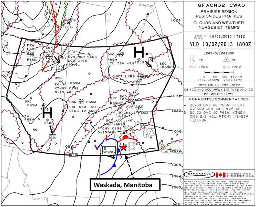
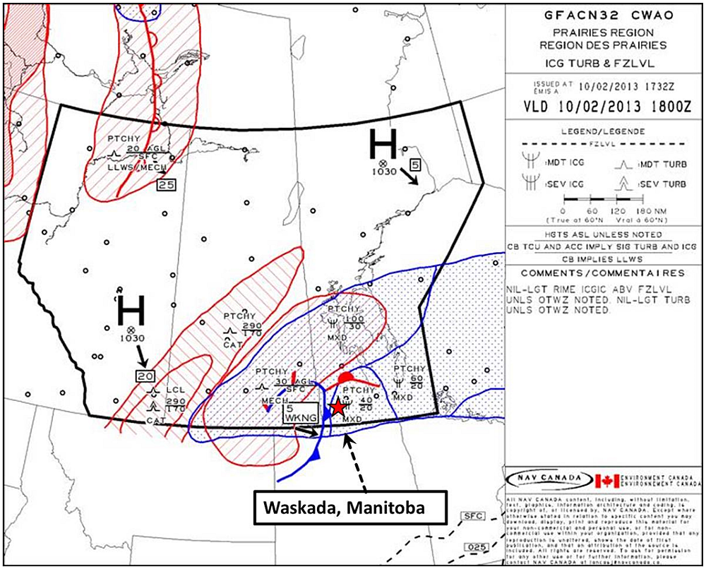
The 1200 aviation routine weather report (METAR) for Brandon, about 63 nautical miles (nm) northeast of the private airstrip, recorded the weather as surface winds 050° at 11 knots and surface visibility ¾ of 1 statute mile (sm) in light snow and mist, with broken clouds at 600 feet above ground level (agl). The graphical area forecast (GFACN32) clouds and weather, and icing, turbulence and freezing level charts for use starting at 1200 on 10 February 2013, indicated an overcast layer of cloud based at 2000 to 3000 feet above sea level (asl) and topped at 6000 feet asl in the Brandon and Waskada area (Appendix A – 1300 CST Clouds and Weather, Appendix B – 1300 CST Icing, Turbulence and Freezing Level). Visibility was forecast to be 4 to greater than 6 sm in light snow with patchy areas of visibility greater than 6 sm. The ceilings in the area were forecast to be 600 to 1200 feet agl, with local visibility 1 sm in light freezing drizzle and mist with ceilings at 300 feet agl.
Pilot
The pilot held a commercial pilot licence (CPL) valid for single-engine landplanes. The pilot did not have an instrument rating endorsement. The pilot met the currency requirements for the carriage of passengers. The pilot’s total flight time was approximately 5890 hours, flown mostly during the summer as an agricultural spraying pilot. The pilot had accumulated approximately 265 hours in the last 12 months. Autopsy results indicated that there were no pre-existing physiological conditions that would have impaired the pilot’s ability to conduct the intended flight.
Flight crew recency requirements self-paced study program
In order to meet the recency requirements listed in the Canadian Aviation Regulations (CARs) Part 401.05 (24-month recurrent training program), the pilot had completed the required Transport Canada (TC) questionnaire on 8 May 2012. The questionnaire is primarily based on the Aeronautical Information Manual (AIM). There are AIM references at the end of each question. However, there are no questions based on Section AIR 2.12.7 of the AIM, which discusses the dangers of whiteout.
The focus of the TC self-paced study programs has been on updating pilot knowledge with a particular emphasis on questions causing the pilots to study areas of recent change. Although information about whiteout has not changed appreciably over the period of this pilot holding a licence, the Self-Paced Study Program does periodically include this topic to ensure periodic reviews in order to keep the subject fresh in pilots’ minds.
The Self-Paced Study Program changes annually with questions and topics rotating into and out of the questionnaire. Whiteout was specifically addressed in the Self-Paced Study Program, most recently in 2003, 2004 (aimed at all aircraft), and in 2008 (aimed at helicopters). The Self-Paced Study Program is distributed as part of Transport Canada publication number TP 185, Aviation Safety Letter; the topic of whiteout and inadvertent entry into IMC has appeared in 8 of the past 10 Aviation Safety Letters and is included within the Self-Paced Study Program of issues 4/2003 and 4/2004.
Winter weather conditions and whiteout
The accident occurred in an area of gently rolling hills, which were completely snow covered. There were few trees or other features to provide visual references. The terrain, coupled with the reported meteorological conditions, was conducive to whiteout. Section AIR 2.12.7 of the AIM states:
Whiteout (also called milky weather) is defined in the Glossary of Meteorology (published by the American Meteorological Society) as:
An atmospheric optical phenomenon of the polar regions in which the observer appears to be engulfed in a uniformly white glow. Neither shadows, horizon, nor clouds are discernible; sense of depth and orientation is lost; only very dark, nearby objects can be seen. Whiteout occurs over an unbroken snow cover and beneath a uniformly overcast sky, when with the aid of the snowblink effect, the light from the sky is about equal to that from the snow surface. Blowing snow may be an additional cause.
Flight in whiteout conditions may result in a poorly defined visual horizon that will affect the pilot’s ability to judge and stabilize aircraft attitude, or reduce the pilot’s ability to detect changes in altitude, airspeed, and position. If visual cues are sufficiently degraded, the pilot may lose control of the aircraft or fly into the ground or surface of the water.
The AIM recommends that pilots avoid such conditions unless the aircraft is equipped with the suitable instruments, and they are sufficiently experienced. In order for a pilot to escape from whiteout conditions, it is necessary to either effectively transition from visual to instrument flight or be able to quickly regain sight of visual contrast. If at low level, a climb or a turn toward an area where sharp terrain features can be seen should be initiated. It is generally considered to be a difficult task for even an experienced instrument pilot to make a successful transition from visual to instrument flight after inadvertent entry into instrument meteorological conditions.
Pilot spatial orientation
Vision is the dominant sense enabling pilot spatial orientation. Peripheral vision is the primary source of spatial orientation, with vestibular organs and kinesthetic sensors also contributing. In the absence of adequate visual cues when peripheral vision is limited, vestibular and kinesthetic illusions or false impressions can occur. This sometimes results in pilot disorientation and loss of situational awareness, which can lead to loss of aircraft control. In instrument meteorological conditions (IMC), the pilot must rely on instruments instead of instinct to overcome illusions or false impressions.Footnote 2 In visual meteorological conditions (VMC) the pilot relies on outside references to control the aircraft.
Inadvertent flight into IMC and loss of control
Transport Canada has published many articles concerning whiteout and flight into IMC with no instrument rating endorsement. The information available concerning inadvertent flight into IMC by unqualified pilots and the inevitable outcome is widely available, in documents such as Transport Canada publication number TP 2228E-1, Take Five for Safety, 178 Seconds.
Aircraft
The Cessna 210C is a 4-seat, single-engine aircraft, equipped with retractable landing gear, certified for use in day and night, VFR and IFR operations, with a maximum take-off weight of 3000 pounds. The aircraft was not equipped, nor was it required to be equipped, with a cockpit voice recorder (CVR) or a flight data recorder (FDR). The Cessna 210 Owner’s Manual indicates that the never-exceed speed (VNE) is 225 mph and the cruise speed is 188 mph at 7000 feet and engine at 75% power.
Records indicate that the aircraft was certified, equipped, and maintained in accordance with existing regulations and approved procedures. A review of the technical records indicated that the aircraft had no outstanding defects.
The aircraft weight was within the specified maximum allowable take-off limit and its centre of gravity was within its envelope.
Aircraft wreckage and impact information
The aircraft struck the ground on an easterly heading, with the right wing low, at nearly 90° of bank angle. Condition of the wreckage was consistent with a high vertical speed and forward speed. The wreckage trail was approximately 320 feet long and the aft fuselage section came to a rest in an upright position. Contents of the aircraft were scattered approximately 2/3 of the way down the wreckage trail, indicating an early breakup of the cabin and cockpit area.
Inspection of the wreckage revealed that there was no evidence of any ice accumulation on the wings or other critical aerodynamic surfaces. Temperatures had remained below freezing since the occurrence. The landing gear selector was found in the gear up position and the landing gear was retracted at the time of impact. The flap selector was found in the flap up position and the flaps were retracted at the time of impact.
An inspection of the fuel selector pedestal revealed that the fuel selector handle was set to the right fuel cell position. The aircraft wings displayed heavy signs of bulging and bursting in the areas of the fuel cells, the result of fuel movement at impact when all the remaining fuel is momentarily compressed into a section of the fuel cell, deforming the bladder and structure surrounding it. Damage to the propeller suggests that the engine was producing substantial power at the time of impact.
Emergency locator transmitter
The aircraft was equipped with a 121.5 Megahertz (MHz) ELT. ELTs were originally intended to use the 121.5 MHz frequency to alert air traffic control and aircraft monitoring that frequency. In 1982 COSPAS-SARSATFootnote 3, a satellite-based monitoring system, was implemented to provide a better receiving source for ELT signals. As of 01 February 2009, the international satellite system discontinued satellite-based monitoring of the 121.5 MHz frequency. However, the signals may be received by aircraft monitoring that frequency.
The satellite system now monitors the 406 MHz frequency only. It was recommended that aircraft operators change their 121.5 MHz ELT to the new digital 406 MHz ELT, which also enables search and rescue personnel to retrieve information specific to the owner and the aircraft. The 406 MHz ELT transmits digital coded signals, which can be compared to point of contact information if registered, enabling rapid incident corroboration by telephone or radio call and faster deployment of SAR personnel.
An overflying aircraft received the ELT signal at approximately 1317. Procedures had to be initiated to confirm that the signal was valid because of the high false alert rate of the 121.5 MHz ELT. The 121.5 MHz ELT signals cannot be pinpointed by satellite because there is no satellite monitoring, and aircraft at high flight levels can receive these signals over a vast area (up to 164 nm at 30 000 feet); for these reasons, significant investigation must be undertaken to narrow the search area. Once the search area has been narrowed, and it is determined that it is probably an aircraft in distress, homing procedures are initiated on the signal. These procedures were ongoing when a family member reported to SAR services that C-FWUX was overdue at 1610. An SAR aircraft was launched at 1720 and on scene at 1750.
Transport Canada CARs 602.73 (2) stipulates that no pilot-in-command shall operate an aircraft in VFR flight unless a VFR flight plan or a VFR flight itinerary has been filed, except where the flight is conducted within 25 nm of the departure aerodrome.
The pilot did not file a flight plan or flight itinerary. A flight plan or flight itinerary would have provided the JRCC with information regarding the flight and the aircraft. This information likely would have shortened the time required to confirm the validity of the ELT signal and initiate the SAR procedures.
Component testing and examination
Several cockpit instruments, flight control cables and structural components were sent to the TSB Laboratory for further analysis.
Gouge marks on the dial face of the airspeed indicator show the airspeed pointer at approximately 190 mph at impact. The fuel quantity gauge was likely indicating ¼ tank. Marks on the exhaust gas temperature (EGT) gauge, and the oil pressure and oil temperature gauges show they were all within normal range at impact.
Damage to the Garmin GPS was too extensive to retrieve any information from the device.
Examination of the structural components of the wings and the control cables revealed no evidence of any fatigue failures. All failures were overload in nature, resulting from the impact.
TSB Laboratory reports
The following TSB Laboratory reports were completed:
- LP034/2013 Instruments, Garmin aera 500 GPS;
- LP036/2013 Wing Components and Control Cable Examination.
The reports are available from the TSB upon request.
Analysis
Examination of the engine, the engine instruments and the propeller indicated that the engine was functional and producing power at impact. The examination of the airspeed indicator showed that VNE had not been exceeded at impact, which occurred at approximately cruise speed. All control surfaces were present and all breaks throughout the control system were found to be overload in nature, and had occurred at impact. Consequently, no aircraft technical malfunction was identified.
The meteorological conditions at takeoff were VMC, but some areas of IMC were forecast in the GFA. The snow-covered terrain, combined with the meteorological conditions, was conducive to whiteout. In whiteout conditions, the snow and fog would blend together and under these conditions, the pilot would not be able to fly using visual references. Whiteout would also make it more difficult to identify an area of local fog, and more difficult to exit such an area if it were encountered.
It is therefore probable that the pilot encountered whiteout conditions and was unable to accurately judge, through visual reference, his altitude above the ground. In the absence of a visible horizon, the pilot likely experienced spatial disorientation, particularly if he initiated a turn to avoid the deteriorating weather. The pilot’s lack of instrument training and experience would have made him more susceptible to the effects of whiteout and spatial disorientation.
The procedures to confirm the validity of the 121.5 MHz ELT signal received by the overflying aircraft had to be initiated because of the high false alert rate of the 121.5 MHz ELT. Under these circumstances, it took about 2 hours and 53 minutes before SAR personnel could be deployed. The use of a 406 MHz ELT, with its point-of-contact information, might have reduced the response time.
The content of the TC Self-Paced Study Program is modified annually, with questions and topics rotating into and out of the document. The current document did not address the topic of whiteout or inadvertent flight into IMC, but it was specifically addressed in 2003, 2004 (aimed at all aircraft), and in 2008 (aimed at helicopters).
Findings
Findings as to causes and contributing factors
- The meteorological conditions in the area were conducive to whiteout.
- The pilot likely flew inadvertently into instrument meteorological conditions (IMC), lost situational awareness, and lost control of the aircraft, resulting in impact with terrain.
Findings as to risk
- Aircraft equipped with 121.5 MHz ELTs, which require procedures to be followed that take more time than 406 MHz ELTs, are at increased risk of delay in the initiation of search and rescue procedures.
Other findings
- The current flight crew recency requirements Self-Paced Study Program did not include information pertaining to the risks of white-out or inadvertent flight into IMC, but the topic has been addressed periodically, most recently in 2008.
This report concludes the Transportation Safety Board’s investigation into this occurrence. Consequently, the Board authorized the release of this report on . It was officially released on .