Controlled flight into terrain
Kenn Borek Air Ltd.
de Havilland DHC-6-300 Twin Otter C-GKBC
Mount Elizabeth, Antarctica
The Transportation Safety Board of Canada (TSB) investigated this occurrence for the purpose of advancing transportation safety. It is not the function of the Board to assign fault or determine civil or criminal liability. This report is not created for use in the context of legal, disciplinary or other proceedings. See Ownership and use of content. Masculine pronouns and position titles may be used to signify all genders to comply with the Canadian Transportation Accident Investigation and Safety Board Act (S.C. 1989, c. 3).
Summary
The Kenn Borek Air Ltd. de Havilland DHC-6-300 Twin Otter, (registration C-GKBC, serial number 650) departed South Pole Station, Antarctica, at 0523 Coordinated Universal Time on 23 January 2013 for a visual flight rules repositioning flight to Terra Nova Bay, Antarctica, with a crew of 3 on board. The aircraft failed to make its last radio check-in scheduled at 0827, and the flight was considered overdue. An emergency locator transmitter signal was detected in the vicinity of Mount Elizabeth, Antarctica, and a search and rescue effort was initiated. Extreme weather conditions hampered the search and rescue operation, preventing the search and rescue team from accessing the site for 2 days. Once on site, it was determined that the aircraft had impacted terrain and crew members of C-GKBC had not survived. Adverse weather, high altitude and the condition of the aircraft prevented the recovery of the crew and comprehensive examination of the aircraft. There were no indications of fire on the limited portions of the aircraft that were visible. The accident occurred during daylight hours.
Factual information
History of the flight
The purpose of the flight was to reposition the aircraft and crew to support an Italian research team located at Terra Nova Bay, Antarctica. The flight was conducted under visual flight rulesFootnote 1. The route of flight had been flown by the captain approximately 16 times in 8 seasons in the Antarctic. Prior to departure, the aircraft had taken on 634 US gallons of fuel.
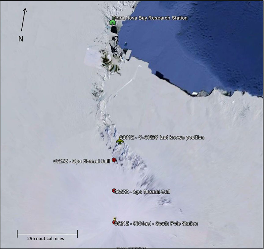
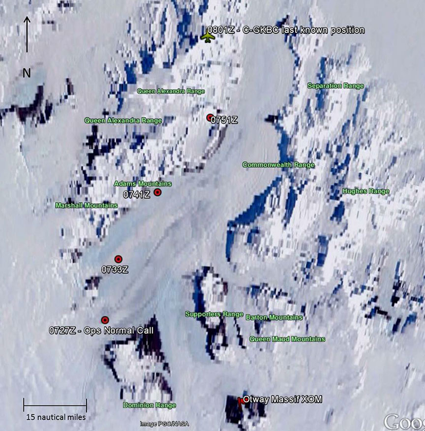
C-GKBC climbed to 11 000 feet above sea level (asl) and called into South Pole Station at 0627Footnote 2 via radio to report that operations were normal. The onboard SkyTrac ISAT-100 tracking equipment showed that C-GKBC proceeded along a track of 358° true (T) flying by position 87°23'3" S, 164°50'52" E at 0629, at which point the aircraft descended to 10 000 feet asl. At 0725, C-GKBC turned right to 032°T followed 2 minutes later by a descent to 9100 feet asl (85°05'32" S, 164°41'57"E). Another position report was radioed in to South Pole Station at 0727 indicating that operations were normal. At 0749, SkyTrac showed a climb was initiated to 12 500 feet asl followed by a heading change to approximately 350°T. At 0801, the SkyTrac unit transmitted a final global positioning system (GPS) position of 83°53'30"S, 168°33'45" E (figure 1 and figure 2). A position report for 0827 was not received, which initiated the activation of the Emergency Operations Center (EOC) at the United States McMurdo Station, and a communications search was begun.
Search efforts
The initial emergency locator transmitter (ELT) alert from C-GKBC was received at 0856. The position of the aircraft was fixed at 1000 in the vicinity of Mount Elizabeth. Poor weather conditions prevented search activities.
SKIER 33, a U.S. Air National Guard C-130 aircraft, departed Otway Massif (92 nautical miles [nm] south of the accident site) at 1100 and overflew the site at approximately 1205. The crew of SKIER 33 was not able to make radio contact with the crew of C-GKBC and was unable to locate the site visually due to a cloud layer below the search aircraft.
Weather conditions had improved enough for a Kenn Borek Air Ltd. DC3T aircraft to depart and fly over the site at 2230. The aircraft orbited the site for 5 hours, but the crew was unable to see the site due to heavy cloud cover.
Kenn Borek Air Ltd. deployed a Twin Otter and a DC3T on 25 January 2013, in addition to a Petroleum Helicopters (PHI) Bell 212 helicopter and a New Zealand South Lake Helicopter Eurocopter AS350-B3, to the Central Trans Antarctic Mountains fuel cache in the Beardmore area to establish a search and rescue base camp. A Joint Antarctic Search and Rescue Team (JASRT), operated by the U.S. and New Zealand, was also deployed.
The occurrence aircraft was spotted by the crew of an LC-130 at 0235 on 26 January 2013. A second reconnaissance flight was conducted by a Kenn Borek Air Ltd. Twin Otter at 0426. No signs of activity at the accident site were observed.
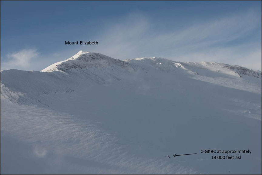
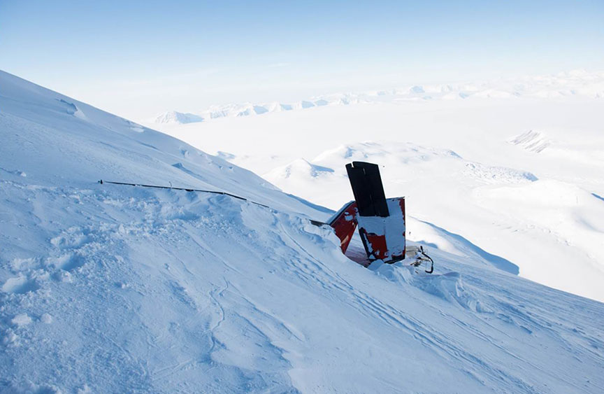
On 27 January 2013 a search and rescue (SAR) team was positioned, via helicopter, on a ridge approximately 1000 feet above the accident site. The crash site was located at about 13 000 feet asl on a steep slope (Photo 1 and Photo 2). The crash area exhibited signs of crevasses and avalanche activity.
The cockpit voice recorder (CVR) and a satellite tracking unit were recovered from the tail section of the aircraft, which was exposed above the ice and snow. The aircraft was equipped with long-range ferry fuel tanks, which had crumbled on impact and blocked access to the cabin area. Fuel was observed to be leaking inside the aircraft. The roof of the aircraft had collapsed into the cabin. The cabin was filled with, and surrounded by, packed snow.
The SAR team evaluated the site and determined that recovery operations could not be safely continued and the recovery operation was suspended for the season.
On 06 October 2013, a Kenn Borek Air Ltd. aircraft overflew the accident site and reported that the occurrence aircraft was buried in snow and that a small portion of the tail was visible from the air. Given the location of the accident site and the inherent dangers associated with an attempt to recover the flight crew, a recovery operation was not planned.
Weather
Weather observations and forecasting in the Antarctic, despite the concentration of scientific activity, was relatively sparse. The investigation team recruited climate researchers from the University of Colorado Boulder to conduct an analysis of the weather conditions in the vicinity of Mount Elizabeth using data from the Antarctic Mesoscale Prediction System (AMPS) and automatic weather stations (AWS). It should be emphasized that the weather data was not exact, but does suggest the likelihood of those conditions being encountered on the occurrence flight.
The atmospheric model indicated that, in the vicinity of Mount Elizabeth, the winds were generally from the east and not stronger than 35 knots at the time of the occurrence. Using the AMPS to forecast the cloud level in the area was also challenging. A measure of the total condensate in the atmosphere was analyzed, and indicated a relatively constant amount. As such, it would probably represent conditions at the time of the occurrence. The model indicated that it was likely that there was a widespread cloud layer over the Beardmore Glacier from 13 100 feet asl to 14 700 feet asl. A cloud layer over the Ross Shelf at the base of the Beardmore Glacier may have been at approximately 9800 feet asl.
Weather conditions observed by SAR aircraft 4 ½ hours after the accident in the vicinity of Mount Elizabeth was a solid cloud deck, topping at approximately 16 000 feet asl, with a break in the clouds in the east grid. Mountain wave conditions with high winds and associated turbulence existed.
Flight crew
Records indicate that the flight crew was certified and qualified for the flight in accordance with existing regulations.
The captain of the occurrence flight had been employed by Kenn Borek Air Ltd. since January 1992 and held a valid Airline Transport Pilot's licence issued by Transport Canada. At the time of the occurrence, the captain had approximately 22 300 hours of flight time, of which 7770 hours were on the Twin Otter. The captain had received company training on high altitude flight operations and controlled flight into terrain (CFIT). As part of the company's initial and annual ground training on CFIT, flight crews were provided training about the operational characteristics, capabilities and limitations of ground proximity warning systems (GPWS). This was the captain's eighth season operating in the Antarctic.
The first officer (FO) of the occurrence flight had been employed with Kenn Borek Air Ltd. since December 2010. He held a valid Commercial Pilot's licence issued by Transport Canada. At the time of the occurrence, the FO had accumulated approximately 790 hours of flight time, of which about 450 hours were on the Twin Otter. Like the captain, the first officer had received company training on high altitude flight operations, controlled flight into terrain, and GPWS. This was the first officer's first season in the Antarctic.
Accompanying the flight was the aircraft's crew chief, who was responsible for ongoing maintenance on the aircraft while in the Antarctic. He held a valid Aircraft Maintenance Engineer (AME) licence issued by Transport Canada and had been employed with Kenn Borek Air Ltd. since April 2005.
Aircraft
The de Havilland DHC-6-300 Twin Otter C-GKBC, serial number 650, was certified in Canada under Type Certificate A-82. Supplemental Type Approval SA96-103 authorized the installation of 2 Pratt & Whitney Canada PT6A-34 engines de-rated to limit available power to 620 shaft horsepower. Records indicate that the aircraft was certified, equipped and maintained in accordance with existing regulations and approved procedures.
Prior to deploying to the Antarctic, C-GKBC had undergone an extensive pre-deployment inspection at its home base in Calgary, Alberta, in October 2012. Routine maintenance in the Antarctic was carried out by the Kenn Borek Air Ltd. AME who was on board the occurrence flight.
The aircraft had accumulated in excess of 28 200 flight hours since manufactured in 1979. The aircraft was normally configured for 9 passengers and 2 flight crew, with a maximum take-off weight of 12 500 pounds. Passenger seats were removed for the installation of a long-range ferry fuel system, which increased the maximum take-off weight to 17 500 pounds. The installation of the long-range ferry tanks was under a Transport Canada Ferry Permit.
At the time of the occurrence, the aircraft weighed approximately 14 600 pounds and was within the centre of gravity limits.
According to aircraft maintenance records, the aircraft was equipped with a functioning supplemental oxygen system. The serviceability of that system and oxygen quantity available could not be determined post accident.
The occurrence aircraft was equipped with a Fairchild L3 Model A100 (S/N 6024) CVR. The unit was recovered during the search and rescue operations and transported to the TSB Laboratory in Ottawa, Ontario. This unit was capable of recording 30 minutes of audio data on 4 channels. The unit was last certified in January 2012 and installed in October 2012. The last recorded data was determined to have been from a flight conducted on 01 December 2012; therefore the unit did not contain any data related to the occurrence flight.
None of the records recovered by the investigation team indicated that the failure of the CVR was noticed by the flight crew. The company operations manual did not contain direction to the flight crew requiring a periodic functional check of the unit. The occurrence flight was required by regulationFootnote 3 to have a functioning CVR.
The SkyTrac ISAT-100 position/data communicator was recovered and taken to the TSB Laboratory. The unit was capable of recording flight data in 5-–second intervals, and recorded data from 0517 to 0801 on the day of the occurrence. Data on the aircraft's position, altitude, ground speed and true track was retrieved from the unit.
C-GKBC was equipped with a Canadian technical standard order (CAN-TSO) C151b certified Sandel ST3400 terrain awareness and warning system (TAWS) and two Garmin GNS 430W navigation receivers with the capability for terrain advisory.Footnote 4 An analysis of GPS performance by the U.S. Air Force Space Command determined that at the time of the occurrence the position error was less than 2.2 metres. There were no significant solar or geophysical weather events that would have affected GPS accuracy.
Evolution in the technology underlying ground proximity warning systems (GPWS) has given rise to the terrain awareness warning system (TAWS). Improvements include earlier aural and visual warnings under more conditions than GPWS; forward-looking terrain display based on aircraft position and a terrain database; and the development of a terrain clearance altitude relative to a runway, which provides alerts and warnings regardless of landing gear and flap settings.
Regulations requiring the installation of TAWS in private turbine-powered aircraft and all commercial airplanes configured with 6 or more passenger seats were introduced in 2012.Footnote 5 As the occurrence flight was a VFR ferry flight to Terra Nova and was not configured for 6 or more passengers, a TAWS was not required under existing regulations.
The Sandel ST3400 TAWS unit was certified to meet the new regulations' Class B requirements, which include a forward-looking terrain avoidance (FLTA) mode. To enable the FLTA mode's aural and visual warnings, a terrain database for the area of operation has to be installed. The database available for the ST3400 unit did not cover the area beyond 70°S latitude which meant that the TAWS system would not function there: the unit would not have generated warnings or advisories for the accident location, and would have displayed “Terrain Fail” because it was operating outside the geographic region captured by the database.Footnote 6
Regulations do require a terrain database for the area of operations for aircraft with 6 or more passenger seats if flights are conducted under instrument flight rules (IFR). Currently, some manufacturers have limited coverage between the North Pole and the 70th parallel north, and between the South Pole and the 70th parallel south, putting the Antarctic region as well as a large portion of the Canadian Arctic out of range. It is the operator's responsibility to ensure data is available for the type and area of operation.
The Garmin GNS 430W was not certified to CAN-TSO C151b standards, but it was capable of visual warnings with respect to terrain proximity. It does not have an aural TAWS alert function but it can display pop-up visual warnings. The FLTA mode looks forward of the aircraft's lateral and vertical flight path relative to the terrain database to provide an alert if a potential conflict exists. In order to enable the terrain function, the system requires a valid 3-dimensional GPS position with specific vertical accuracies and a valid terrain database for the geographic area of operation.
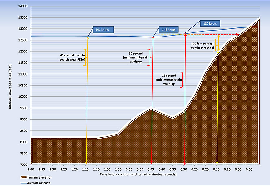
The terrain databaseFootnote 7 installed in C-GKBC contained worldwide terrain data encompassing the occurrence flight route. GPS-derived altitudes are converted to mean sea level (MSL)–based altitudes displayed as GPS sea level (GSL) altitudes, which are used as a comparator to the terrain database's MSL altitudes to determine alerts.Footnote 8 Appendix A depicts the minimum FLTA advisory and warning criteria for the terrain in the accident area. At 45 seconds prior to impact, it appears that C-GKBC entered a climb, which may correlate with receipt of a 30-second terrain advisory. At an altitude of approximately 12 500 feet asl and an operational weight of about 14 600 pounds, the aircraft would have been capable of a 700-feet-per-minute climb.Footnote 9
TSB Laboratory reports
The following TSB Laboratory reports were completed:
- LP 027/2013 – ISAT-100 Download
- LP 028/2013 – CVR Download
Analysis
The circumstances surrounding the accident were difficult to determine given the limited access to the accident site and lack of data, which could have revealed details of the last moments of the flight. Data from the cockpit voice recorder would have been particularly useful. The unit was not functional on the occurrence flight; consequently, details of the flight crew's interaction and decision making were not available to the investigation.
Information recovered from the SkyTrac ISAT-100 tracking unit enabled the investigation to reconstruct C-GKBC's route. The reconstruction did not indicate any aircraft performance anomalies. Flight track, altitude, and ground speed remained relatively constant throughout the flight. At 0749, C-GKBC initiated a turn to the left that would have led directly to Terra Nova, but the aircraft's altitude was insufficient to clear Mount Elizabeth.
Weather model analysis suggests that after the turn into the Beardmore Glacier, C-GKBC may have entered an area covered by cloud, and the crew's view of Mount Elizabeth was likely to have been obscured. The occurrence aircraft was equipped with an FLTA system, and the initiation of a climb approximately 45 seconds prior to impact suggests that the crew might have responded to a terrain warning, but aircraft climb performance was not sufficient to avoid the terrain.
Findings
Findings as to causes and contributing factors
- The crew of C-GKBC made a turn prior to reaching the open region of the Ross Shelf. The aircraft might have entered an area covered by cloud that ultimately led to the aircraft contacting the rising terrain of Mount Elizabeth.
Other findings
- The cockpit voice recorder (CVR) was not serviceable at the time of the occurrence.
- The company did not have a practice in place to verify the functionality of the CVR prior to flight.
- The rate of climb recorded in the SkyTrac ISAT-100 tracking equipment prior to contacting terrain was consistent with the performance figures in the DHC-6 Twin Otter Series 300 Operating Data Manual 1-63-1, Revision 7.
Safety action
Safety action taken
Kenn Borek Air Ltd.
Kenn Borek Air Ltd. has conducted an internal proactive assessment of its operations as a result of this occurrence. In the course of the assessment, the company has identified and taken steps to mitigate the risks associated with its worldwide operations. Kenn Borek Air Ltd. has taken the following corrective actions:
- taken over flight-following in the Antarctic from a third-party flight-following organization, so as to maintain greater operational control;
- amended its GPS standard operating procedures to prevent incorrect data input;
- improved the accuracy of aviation navigational charts in the Antarctic and developed company visual flight rules (VFR) routes for flights exceeding 400 nm.
- implemented a TAWS limitation awareness program for flights above the 70th parallel north and below the 70th parallel south.
- amended its pre-start checklist to confirm that an adequate oxygen supply is on board the aircraft, and that the cockpit voice recorder is functional; and
- improve administrative oversight of daily aircraft inspections.
This report concludes the Transportation Safety Board's investigation into this occurrence. the Board authorized the release of this report on . It was officially released on .
