Loss of control
ExpressJet Airlines
Embraer EMB-145LR, N16954
London, Ontario, 53 nm W
The Transportation Safety Board of Canada (TSB) investigated this occurrence for the purpose of advancing transportation safety. It is not the function of the Board to assign fault or determine civil or criminal liability. This report is not created for use in the context of legal, disciplinary or other proceedings. See Ownership and use of content. Masculine pronouns and position titles may be used to signify all genders to comply with the Canadian Transportation Accident Investigation and Safety Board Act (S.C. 1989, c. 3).
Summary
The ExpressJet Airlines Embraer EMB-145LR, flight number 4538 (registration N16954, serial number 145072) departed Grand Rapids, Michigan, on an instrument flight rules flight destined for Newark Liberty International Airport, Newark, New Jersey. After departure, the aircraft deviated north of its desired track to avoid thunderstorms and climbed to its cruising altitude of flight level 370. At approximately 1915 Eastern Daylight Time, the aircraft flew through a large thunderstorm and encountered severe turbulence. The flight crew lost control of the aircraft, and it descended rapidly, losing approximately 4000 feet before the flight crew were able to regain control. The aircraft continued to its destination, where it landed safely. There were no reported injuries to the 3 crew members or 26 passengers, and the aircraft was not damaged.
Factual information
History of the flight
At 1759,Footnote 1 the ExpressJet Airlines (ExpressJet) Embraer EMB-145LR, flight number 4538 (registration N16954, serial number 145072), began manoeuvring at the Grand Rapids Airport (KGRR), Grand Rapids, Michigan, in preparation for departure. Because of local thunderstorms at the airport, a ground stop ensued; as a result, the flight crew were prohibited from manoeuvring the aircraft at the airport. During this time, the pilots viewed the convective activity and precipitation using weather applications on their mobile phones to determine the most viable route for the flight to Newark Liberty International Airport (KEWR), Newark, New Jersey.
The flight crew decided that the line of thunderstorms appeared to be fragmented enough, with sufficient openings, to allow them to deviate from their planned route (Figure 1) around the weather system. At 1845, the aircraft departed and deviated 50 nautical miles (nm) north-northeast of KGRR. After its initial deviation, the aircraft turned east, paralleling a line of thunderstorms south of its position. The aircraft was in visual meteorological conditions (VMC).
![Depiction of weather at time of departure (1845) and the aircraft's planned flight route (dashed line) (Source: National Oceanic and Atmospheric Administration [NOAA], National Weather Service, with TSB annotations)](/sites/default/files/eng/rapports-reports/aviation/2014/a14o0165/images/a14o0165-figure-01.jpg)
The aircraft initially climbed to flight level (FL)330,Footnote 2 where it remained for 1 minute, and then climbed to its assigned cruise altitude of FL370, which is the maximum operating altitude of the aircraft. During the climb, the aircraft experienced light turbulence.
While flying eastbound, the crew used the on-board weather radar system to see the weather system ahead. As the aircraft was in VMC, the flight crew also visually identified openings between the thunderstorms ahead. As the flight progressed, the crew observed the thunderstorms billowing, closing the gaps in the route ahead.
Soon after reaching FL370, the aircraft began to experience increasing turbulence. The aircraft speed was 0.63 Mach.Footnote 3Footnote 4 At this point the flight crew were communicating with Toronto Area Control Centre (ACC) and had appropriate clearance to deviate from their intended route to avoid the weather system.
At 1908, the flight crew communicated with the company dispatch via the aircraft communication and recording system to request a route through the weather system, stating that they needed help picking their way through the storms and that the gaps between storm cells were closing quickly.
At approximately 1914, the dispatcher, viewing the company flight-following/weather softwareFootnote 5 (Figure 2), suggested that the flight crew proceed directly to Chris Hadfield Airport (CYZR), Sarnia, Ontario, and then to Erie International Tom Ridge Field Airport (KERI), Erie, Pennsylvania. The crew then turned the aircraft southbound toward Sarnia.
Shortly after turning southbound, the aircraft flew into instrument meteorological conditions.
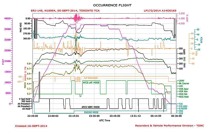
At 1914:55, the turbulence increased and became more intense over a period of 1 minute.
At 1915:20, the management of the engines' thrust was switched to the CRZFootnote 6 mode, the throttle lever angle (TLA) was reduced from 76° to 61°, and the engine compressor speeds (N1) decelerated from 94% to 85% over a seven-second period.
At 1915:27, the flight crew progressively increased the TLA from 61° to 74°, and the engines' N1 increased from 85% to 93%. During that period, speed increased to 0.76 Mach, and the intensity of the turbulence increased, with peak vertical acceleration values of 0.49g and 1.42g.
At 1915:51, the TLA was reduced to 25°. Over the following 13 seconds, there was a corresponding deceleration in N1 speed from 93% to 60%. During this thirteen-second period, speed increased to 0.79 Mach, the turbulence became more intense with peak values of 0.41g and 1.7g, and the roll attitude became unsteady, with the aircraft banking at angles ranging between 45° left and 14° right.
Radar data obtained after the occurrence indicated that, at 1916, the aircraft was flying in a southerly direction, through a line of thunderstorms (Figure 3).
![Flight path (dashed line), weather, and aircraft location at 1916. The weather depiction was generated by a composite reflectivity radar source, using the maximum reflectivity from all of the multiple elevation angles. (Source: National Oceanic and Atmospheric Administration [NOAA], National Weather Service, with TSB annotations)](/sites/default/files/eng/rapports-reports/aviation/2014/a14o0165/images/a14o0165-figure-03.jpg)
The autopilot disengaged coincidentally with the peak vertical acceleration values at the moment when the aircraft exceeded 0.78 Mach.Footnote 7 The aircraft climbed and exceeded the assigned cruise altitude of FL370 without air traffic control clearance.
The flight crew re-engaged the autopilot; however, the aircraft continued to climb through FL374 with increased turbulence. Three seconds later, vertical acceleration hit peaks of 0.20g and 1.7g, and the autopilot disengaged again. The pitch attitude was −1.7°, the angle of attack fluctuated from 3.8° to −9.9°, the outside air temperature was −45.4 °C, the speed was decelerating through 0.68 Mach, and the aircraft continued to climb through FL375.
At 1916:19, the aircraft reached the peak of its altitude excursion, FL376, 600 feet above the aircraft's maximum operating altitude.Footnote 8 At this point, the uncommanded right bank angle reached 45° and the turbulence momentary peak values were 0.44g and 1.6g. No significant elevator and trim deflections that would have contributed to the climb were commanded.
During the severe turbulence, both before and during the altitude excursion,
- the peak vertical acceleration values fluctuated rapidly within the range of 0.15g to 2.07g;
- the angle of attack fluctuated rapidly within the range of −11.9° and 3.8°; and
- the outside air temperature fluctuated between −51 °C and −45 °C.
At 1916:26, shortly after reaching FL376, the aircraft pitched to 11° nose down and rolled 30° to the right. The flight crew increased the thrust (advancing the TLA to 70°) and, using flight control inputs, commanded an additional right roll. As a result of the crew's additional roll inputs, the aircraft reached a 63° right bank angle. The pitch attitude increased to 13° nose down, and the aircraft reached a descent rate of 3100 feet per minute (fpm). The crew briefly applied left roll inputs, and the right bank angle decreased from 63° to 33°.
At 1916:27, the ice-detection system indicated the presence of ice. The aircraft encountered severe icing conditions. The anti-ice systems were auto-commanded ON for the wing, stabilizer, and engine surfaces.
At 1916:38, as the aircraft was descending through FL368, the rate of descent increased to 4400 fpm; the aircraft was in a 42° right bank. Using the flight controls, the flight crew applied right roll inputs. As a result, the right bank angle increased from 42° to 77°. The roll inputs by the flight crew during the uncommanded descent were contrary to known aircraft upsetFootnote 9-recovery techniques. The correct technique is to roll the aircraft in the shortest direction to wings-level.Footnote 10
The pitch attitude increased to 17° nose down. The aircraft's speed was accelerating through 0.76 Mach, and the severe turbulence persisted.
When the aircraft was descending through FL364, the flight crew applied left roll inputs, and the right angle of bank subsequently decreased to 26°. The descent rate was 7500 fpm, and the pitch angle was 24° nose down.
Beginning at 1916:48, as the aircraft was descending through FL355, the flight crew reduced the thrust (decreasing the TLA from 70° to 25°) over a period of 6 seconds. During those 6 seconds, the turbulence lessened from severe to moderate, the aircraft's pitch attitude decreased to 5° nose down, and the descent rate decreased to 6900 fpm.
At 1917:02, while aircraft speed was 0.80 Mach, the autopilot was briefly engaged for 1 second before being disengaged. The aircraft attitude was stable, and the descent rate had decreased to 2700 fpm while passing through FL338. The turbulence remained moderate.
At 1917:11, at FL336, the descent was arrested; the aircraft had lost approximately 4000 feet of altitude. Shortly afterward, the ice-detection indications stopped, and the aircraft began to climb.
During the period of loss of controlFootnote 11 described in the preceding paragraphs, the aircraft had sustained an average turn rate of 200° per minute, which had changed its heading from 180° magnetic (M) to 240°M, and had reached a peak descent rate of 9300 fpm. Severe turbulence had persisted throughout this period of upset and loss of control. Toronto ACC repeatedly attempted to re-establish radio contact with the aircraft. The flight crew's only response was “stand by,” but this was said with a tone and volume that suggested that something of an urgent nature was occurring.
Over a period of 3 minutes, the aircraft had a varying climb rate before re-establishing a cruise altitude of FL370. The engines were producing thrust of between 85% and 95%. Turbulence changed from moderate to light, and the icing conditions ceased.
As the aircraft climbed, the autopilot was momentarily engaged 3 times. In each instance, it became disengaged during moments of heightened turbulence. Icing conditions returned.
While on a heading of 240°M, the flight crew requested a heading from Toronto ACC to exit the weather system. Again, the tone of voice and volume suggested urgency. Toronto ACC suggested a southbound heading; the aircraft turned southbound and, shortly afterward, exited the weather system.
The aircraft turned eastward, and the flight proceeded to its destination, KEWR. It did not experience any additional encounters with severe turbulence.
Upon arrival in Newark, the flight crew reported a severe turbulence event to the operator. As a result, maintenance performed a severe turbulence inspection on the aircraft and downloaded the flight data recorder (FDR) in accordance with the EMB-145 aircraft maintenance manual. There was no damage reported, or discrepancies noted. The aircraft was released back into service.
During the investigation, the TSB performed an analysis of the FDR data, in which an aircraft overspeed condition was noted. As a result, the TSB notified the operator, which subsequently performed an overspeed inspection.
Flight and weather tracking
The software that ExpressJet uses for flight following and weather monitoring is WSI Fusion. Among other capabilities, it provides the user with real-time aircraft position, flight following, and convective weather monitoring, which uses the lowest reflectivity angle and displays a base reflectivity product. It enables an airline operator to proactively carry out flight planning, avoiding storms or other disruptive events along the aircraft flight path, and to provide optimal flight routing. Through use of those functions, a line of thunderstorms, such as that facing this flight crew, can be avoided, and the aircraft can be rerouted before coming within proximity of the storm.
Aircraft and weather radar
A review of the aircraft flight discrepancy logs did not identify any recorded discrepancies or abnormalities for the occurrence flight.
The aircraft was equipped with a Honeywell Primus 660 on-board weather radar system. The weather radar system is designed to detect and analyze precipitation in storms along the flight path of the aircraft. It provides flight crews with visual indications regarding precipitation intensity, displaying the level of intensity in 4 colours (magenta, red, yellow, and green), contrasted against a black background on the primary flight display and multifunction display radar mode field. Magenta represents the heaviest rainfall intensity, while green indicates the lightest. The weather radar system can see rain, wet snow, wet hail, and dry hail (depending on its diameter); it cannot see water vapour, ice crystals, or small dry hail.
Some of the limitations and issues associated with on-board weather radar systems are described below:
- Attenuation: “Storms with high rainfall rates can attenuate the radar energy, making it impossible to see a second [storm] cell hidden behind the first cell.”Footnote 12 The size, shape, and intensity of the area of precipitation may be greater than that displayed to the pilot. The greater the intensity of the precipitation, the shorter the distance the radar can see when looking into and through a storm.Footnote 13
- Water film over the surface of the radome (the dome covering the radar): When flying in rain at some specific altitudes and speeds, a water film may form on the radome, altering the weather radar indications. The radar precipitation intensity level on the display may disappear or turn red.Footnote 14
- Greased radome: Radar transmission is impaired by the presence of grease or dirt over the radome's surface.Footnote 15
- Cracked radome: “Small holes caused by electrostatic discharges, minor damage to structure or paint can cause water infiltration in the radome's honeycomb composite structure. It can result in significant radar signal attenuation, distortion and in some cases, can cause dark spots on the radar screen.”Footnote 16
The weather radar has several features, such as range, tilt (manual control of the antenna angle), and gain (how much of the energy leaving the antenna is focused in a particular direction), which must be used correctly during operation. If these tools are improperly managed, weather targets can be missed or underestimated. As the FDR does not record parameters from the weather radar unit, it could not be determined with certainty which settings the flight crew were using on the on-board weather radar unit. It also could not be determined how the flight crew were using the weather radar. There were no data to suggest that the weather radar was faulty.
Flight data recorder and cockpit voice recorder
The occurrence was not reported to the TSB by the operator or by the pilot‑in‑command (PIC). The FDR and the cockpit voice recorder (CVR) were not quarantined after the flight. Instead, the occurrence was reported to the TSB by Toronto ACC approximately 24 hours afterward.
The CVR audio of the occurrence had been overwritten. However, the TSB obtained the downloaded digital FDR file from the operator, which contained more than 26 hours and 17 flights, including the occurrence flight.
Flight crew
Records indicate that both pilots were certified and qualified for the flight in accordance with existing regulations.
The captain was the pilot flying. He had accumulated approximately 10 000 flight hours, including 7000 hours on the EMB-145, of which 5000 hours were as PIC. A company check airman, the captain had been employed by the operator for 10 years and had completed his most recent recurrent aircraft-type training in April 2014.
The first officer was the pilot monitoring. He had accumulated approximately 3400 flight hours, including approximately 2200 hours on the EMB-145, and had been employed by the operator for 3 years. The first officer had completed his most recent recurrent aircraft-type training in July 2014.
At the time of the occurrence, United States Federal Aviation Administration regulations requiring mandatory aeroplane upset-prevention and -recovery training did not exist. However, beginning 12 March 2019, all Federal Aviation Regulations (FARs) Part 121 air carriers in the United States will be required to provide flight crews with upset-recovery training.
The roll inputs by the flight crew during the descent phase of the loss of control were contrary to known aircraft upset-recovery techniques; the roll inputs increased the angle of bank, subsequently increasing the altitude loss and recovery time.
ExpressJet does provide flight crews with aircraft upset-recovery training during their recurrent training although it is not yet required by regulations. The company training included at least 2 separate scenarios as pilot flying. These included a nose-high (pitch up) scenario and a nose-low (pitch down) scenario, the latter with a bank angle. In both scenarios, the manoeuvres are conducted at an altitude of between 20 000 and 25 000 feet and at an airspeed of 280 knots, and the atmospheric conditions programmed in the simulator are at the discretion of the examiner.
Although the flight crew had been previously exposed to upset-recovery training, the occurrence was their first exposure to an event involving an upset with turbulence of this degree. Because of current fidelity limitations inherent in full-motion flight simulators and because training scenarios involve some level of expectation, it is difficult to replicate an aircraft upset with turbulence of the severity encountered by the occurrence flight crew.
Weather
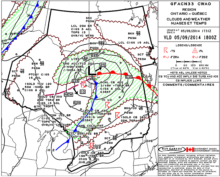
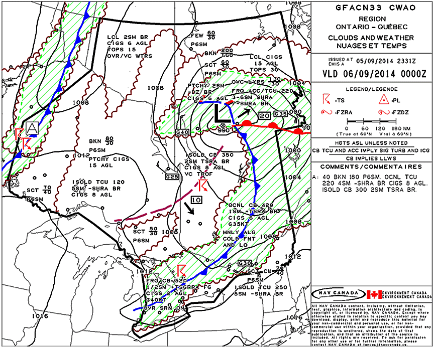
A line of thunderstorms, associated with a cold front, progressed from west to east through southern Ontario during the afternoon and evening on the day of the occurrence. The graphical area forecasts (GFA) covering southern Ontario (GFACN33) issued for the occurrence day (Appendix A) indicated potential for occasional widespread thunderstorms, with tops of 42 000 to 44 000 feet above sea level (asl) at 1400 (1800Z). The GFACN33 issued at 2000 (0000Z) forecasted the following weather along the cold front: frequent cumulonimbus clouds with tops of 52 000 feet asl, heavy thunderstorms, rain, and hail, with winds gusting to 40 knots.
When thunderstorms began to develop, significant meteorological reports (SIGMET)Footnote 17 were sent out after 1400 for the main thunderstorm line affecting the flight path from KGRR to KEWR. A SIGMET already covered the area at the time when, and location where, the severe turbulence was reported between FL330 to FL390. Weather radar in southern Ontario was also reporting precipitation tops above 52 000 feet asl, with heavy rain and hail at the surface.
The Environment Canada radar imagery indicated that small lines of thunderstorms began to develop around 1300 along the Ottawa River Valley, extending into central Michigan. By 1600, there was a line of thunderstorms extending from Wiarton, Ontario, into southern Michigan. By 1900, squall lines had developed along the cold front. At 2030, radar images showed rain rates of more than 65 mm/h and cloud tops above 52 000 feet asl.
At 1659, ExpressJet dispatch generated a weather briefing as part of its dispatch flight release documents. Before departure, the occurrence flight crew reviewed the documents, which included the weather information and convective SIGMETsFootnote 18 for the intended flight route; both pilots were aware of these weather conditions.
A complete weather assessment provided by Environment Canada after the occurrence indicated that the weather at the time of the occurrence was generally as forecasted.
Turbulence and thunderstorms
The causes of turbulent air are varied. Common causes include, but are not limited to, convective air, storm fronts, wake vortices, and clear air turbulence. The latter is a broad categorization of high-altitude turbulence in conditions in which there are no visual cues, such as clouds, to indicate the presence of unstable air. It is difficult to predict and avoid clear air turbulence without the aid of pilot reports.
In this occurrence, although the aircraft was flying at high altitude, the turbulence experienced was not clear air turbulence. The flight path reconstruction, when overlaid and time-synchronized with the graphical weather depiction, clearly indicated that the aircraft encountered the turbulent convective air associated with towering cumulonimbus clouds.
According to the Transport Canada Aeronautical Information Manual, severe turbulence causes large, abrupt changes in altitude and/or attitude. Large variations in indicated airspeed usually result, and flight crew who are subject to severe turbulence may momentarily experience loss of aircraft control. “Occupants are forced violently against seat belts or shoulder straps. Unsecured objects are tossed about. Food service and walking [are] impossible.”Footnote 19
Cumulonimbus clouds are heavy-mass, towering vertical clouds associated with thunderstorms and atmospheric instability. The clouds generally form from water vapour carried aloft by convective air currents. These clouds are capable of producing lightning and other dangerous severe weather, such as tornadoes.
In a cumulonimbus cloud, generally warm moist air rises on the periphery of the cloud structure and cold air descends within the core. At high altitudes, as the 2 air masses mix, there may be severe turbulence and precipitation in the form of ice crystals, hail, or super-cooled water droplets, causing icing conditions.
Thunderstorms tend to develop in clusters of 2 or more. These clusters, comprising individual thunderstorms in various stages of development, may cover vast areas and last for many hours.
The thunderstorms encountered during the occurrence were associated with a cold front. Frontal thunderstorms usually form a line that may extend for hundreds of miles. They pose a special hazard to pilots because they are often embedded in other cloud decks and are therefore impossible to see. An advancing line of frontal thunderstorms should be avoided.Footnote 20 Severe turbulence may extend up to 20 nm from severe thunderstorms.Footnote 21
United States Federal Aviation Regulations
According to the FARs, the PIC has the final authority as to how an aircraft will be operated. FAR 91.3 (Responsibility and authority of the pilot in command) states:
(a) The pilot in command of an aircraft is directly responsible for, and is the final authority as to, the operation of that aircraft.
Exceedance of maximum operating Mach number
The maximum operating Mach number (MMO) is the speed over which the aircraft encroaches on structural and aerodynamic design limits. The formula used to determine the MMO incorporates a margin of protection that permits the aircraft to enter into an inadvertent dive and withstand the subsequent manoeuvring loads required to recover from the dive without sustaining structural damage.
The MMO also provides a margin of protection that permits the aircraft to withstand gust loads at which high-speed buffeting is introduced and stability deteriorates. A typical margin of protection would be in the order of 0.05 Mach. Although MMO incorporates these margins, regulations prohibit intentional operation of an aircraft beyond MMO.Footnote 22
When an aircraft exceeds MMO, the margins of protection diminish. As a result, the structural integrity, stability, and controllability of the aircraft are at risk. These risks are further magnified when flying into turbulent flight conditions and, thus, should be avoided.
The MMO of the EMB-145 aircraft is 0.78. During the occurrence flight, there were instances of MMO exceedance before and during the loss of control (Appendix B). These instances occurred
- just before the altitude excursion above FL370, when the Mach number reached a single transient peak of 0.79. Turbulence was in transition from moderate to severe, which was consistent with the aircraft encountering horizontal gusts associated with the mature cumulonimbus clouds into which it was flying. These horizontal gusts would have contributed to the transient Mach number peak that exceeded MMO.
- during the recovery, while the flight crew were arresting the aircraft descent rate. During a 45-second period, the speed reached transient peak values of 0.782 Mach, 0.801 Mach, 0.791 Mach, 0.788 Mach, and 0.787 Mach. In the seconds leading up to this period, the aircraft had reached a rapid descent rate of 9300 fpm.
High-altitude and high-speed phenomena
Operating an aircraft at high altitudes and high speeds introduces phenomena that may pose a risk to safe flight if they are not well understood by the crew operating the aircraft.Footnote 23 The risks associated with high altitude and high speed include, but are not limited to, adverse weather conditions, turbulent air, wind shear, icing, Mach tuck,Footnote 24 and Mach (high-speed) buffeting.Footnote 25
The TSB Laboratory examined both Mach tuck and Mach buffeting in relation to the occurrence to determine whether they contributed to the aircraft upset. It was determined that it was unlikely that Mach tuck or Mach buffeting contributed to the occurrence.
TSB laboratory reports
The TSB completed the following laboratory report in support of this investigation:
- LP172/2014 – FDR Analysis
Analysis
The investigation did not reveal any system failures or malfunctions that contributed to the occurrence before or during the flight. Therefore, the analysis will focus on the sequence of events leading to the severe turbulence encounter and the loss of control.
The flight crew were aware of the weather conditions and thunderstorm activity for the intended route, and anticipated that they would be able to navigate around or between thunderstorms. The weather was generally as forecasted.
The National Oceanic and Atmospheric Administration (NOAA) radar weather depiction reviewed by the TSB indicated that, at the time of departure, there were gaps in the line of thunderstorms. However, the size and intensity of thunderstorms can change rapidly as they mature or dissipate.
After departure, the flight crew attempted to navigate through an extensive line of thunderstorms. However, as the flight progressed, the line of thunderstorms intensified and, as a result, the flight crew's intended route became obstructed.
As the aircraft continued eastward, the flight crew could not locate an opening that would enable them to continue flying toward their destination. The crew therefore requested assistance from a company dispatcher to help them find a route through the line of thunderstorms.
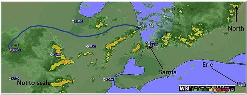
The dispatcher provided an opinion on which route to take, based on what he observed on his display and his assessment of the weather. According to his display (Figure 2), the route was feasible, given the aircraft position and the location of the adverse weather.
However, shortly after turning in the direction suggested by the dispatcher, the aircraft encountered severe turbulence and experienced a loss of control, suggesting that the thunderstorm was more severe at that location than had been indicated by the dispatcher's display.
After the occurrence, the dispatcher's display (Figure 2) was compared with the NOAA radar weather depiction. In the NOAA depiction (Figure 3), the thunderstorm was shown as larger and more contiguous than on the dispatcher's display. The difference in the 2 depictions was due in part to radar reflectivity types. The dispatcher's display is a base reflectivity product, which uses the lowest reflectivity angle, while the NOAA display shows a composite radar return, which uses the maximum reflectivity from all of the multiple elevation angles.
Therefore, the NOAA depiction that showed the weather as more intense was not representative of what the dispatcher was seeing at the time of the flight crew's request for assistance. The dispatcher made a decision based on the flight-following software, which is designed for proactive weather monitoring and flight following. When it is used proactively, a flight can be rerouted before encountering adverse weather, such as a line of thunderstorms. The entire storm area can be avoided by a wide margin.
In this occurrence, when the flight crew requested assistance from dispatch, the aircraft was already positioned in the line of thunderstorms, and the flight crew were navigating between individual storm cells. As a result, the flight-following software was not used as intended (i.e., as a proactive tool to avoid weather), but rather as a reactive response to a thunderstorm encounter. Had the flight crew requested dispatch assistance earlier, a suggestion to help them avoid the weather system completely may have been provided.
The decision to request an alternative route from dispatch was a reasonable action, as dispatch is a resource available to the flight crew. However, the pilot-in-command had no obligation to follow the suggested route, as he had ultimate responsibility for and authority of the aircraft.
There were no reported problems with the on-board weather radar system. If the flight crew were operating the unit within its limitations, thunderstorms should have been displayed to them at some point. At times, the aircraft was in visual meteorological conditions, and the flight crew could see the thunderstorm activity. As a result, they had 3 key pieces of information to aid them in their route decision: visual cues, the on-board weather radar system, and the advice from dispatch. Based on this information, the flight crew decided on a direction of flight. Consequently, the flight crew operated the aircraft through a mature thunderstorm and, as a result, an aircraft upset and loss of control occurred.
Although upset-recovery training was not mandatory at the time of the occurrence, the flight crew were trained in recovery techniques for an aircraft upset. Flying through thunderstorms and encountering severe turbulence of this magnitude is not common. The flight crew likely experienced a level of turbulence that could not be replicated during a training exercise and, therefore, were not proficient in recovering from an upset of this nature. During the loss of control, the flight crew momentarily applied flight control inputs that exacerbated the roll attitude of the aircraft. As a result, the altitude loss and recovery time were increased.
Initially, while at cruise altitude, the aircraft was operating at 0.63 Mach, which is the recommended speed for turbulent air penetration for this aircraft. Shortly afterward, while in moderate turbulence, the flight crew increased the engine power, resulting in an increase in speed of the aircraft to 0.13 Mach above the speed for turbulent air penetration. Although the turbulence-penetration speed is a recommendation, not a limitation, if flight crews operate aircraft outside of manufacturer recommendations, the risk of encountering an adverse consequence is increased.
During the initial stage of the loss of control, the aircraft exceeded the maximum operating altitude. During the rapid descent, the speed increased, and the maximum operating Mach number (MMO) was exceeded. Both exceedances were above the aircraft limitations. Although these limitations were exceeded unintentionally, if aircraft are operated outside of manufacturer limitations, there is a risk of compromising flight safety, resulting in injury to the occupants or damage to the aircraft.
The cockpit voice recorder audio recording of the occurrence had been overwritten. If cockpit voice recordings are not available to an investigation, the identification and communication of safety deficiencies to advance transportation safety may be precluded.
Findings
Findings as to causes and contributing factors
- The flight crew were aware of the weather conditions and departed, anticipating that they would be able to navigate through an extensive line of thunderstorms. However, as the flight progressed, the line of thunderstorms intensified and, as a result, the flight crew's intended route became obstructed.
- The flight crew operated the aircraft through a mature thunderstorm and, as a result, an aircraft upset and loss of control occurred.
- During the loss of control, the flight crew momentarily applied flight control inputs that exacerbated the roll attitude of the aircraft. As a result, altitude loss and recovery time were increased.
Findings as to risk
- If flight crews operate aircraft outside of manufacturer recommendations, the risk of encountering an adverse consequence is increased.
- If aircraft are operated outside of manufacturer limitations, there is a risk of compromising flight safety, resulting in injury to the occupants or damage to the aircraft.
- If cockpit voice recordings are not available to an investigation, the identification and communication of safety deficiencies to advance transportation safety may be precluded.
Safety action
Safety action taken
ExpressJet Airlines
ExpressJet Airlines conducted an internal assessment of its flight operations as a result of this occurrence. In the course of the assessment, the company identified associated risks and took steps to mitigate them. ExpressJet Airlines has taken the following corrective actions:
- The operator has improved the dispatcher use of flight-following software; additional focus has been placed on using the lightning-strike functionality of the weather portion of the software.
- Through the company safety management system, the operator has identified areas for improvement; all involved personnel received focused calibration training in various areas, including
- pilot-in-command and dispatcher joint responsibility, with specific emphasis on issuing information necessary for the safety of the flight
- suspension of operations policy
- policy and procedures related to adverse weather phenomena
- en-route weather monitoring
- AIRMETsFootnote 26 (airmen's meteorological advisory); convective SIGMETs (significant meteorological reports); thunderstorm types, development and avoidance; turbulence; and PIREPs (pilot weather reports)
- radar interpretation
- dispatcher duties and responsibilities.
- The operator has developed a training module for all flight crew members that promotes weather radar utilization techniques both to identify developing storm activity and to avoid severe weather. This training is a proactive step to reinforce previously taught concepts and is part of the 2016 flight crew training.
This report concludes the Transportation Safety Board's investigation into this occurrence. the Board authorized the release of this report on . It was officially released on .