Collision with runway lights on landing
Zetta Jet USA Inc.
BD-700-1A10, N888ZJ
Montréal/St-Hubert Airport, Quebec
The Transportation Safety Board of Canada (TSB) investigated this occurrence for the purpose of advancing transportation safety. It is not the function of the Board to assign fault or determine civil or criminal liability. This report is not created for use in the context of legal, disciplinary or other proceedings. See Ownership and use of content. Masculine pronouns and position titles may be used to signify all genders to comply with the Canadian Transportation Accident Investigation and Safety Board Act (S.C. 1989, c. 3).
Summary
On 15 May 2017, the Bombardier Global Express aircraft (registration N888ZJ, serial number 9071), operated by Zetta Jet USA Inc., was flying from Teterboro Airport, New Jersey, United States, to Montréal/St-Hubert Airport, Quebec, with 3 crew members and 1 passenger on board. At about 1055 Eastern Daylight Time, the aircraft touched down on Runway 06L at Montréal/St-Hubert Airport, partially outside the intended confines of the runway, which had been reduced to 75 feet wide and 5000 feet long owing to construction work. The aircraft struck 7 temporarily installed runway edge lights to the left of the runway. The pilot flying brought the aircraft back to the reduced-width runway centreline before it came to a stop approximately 300 feet from the end of the shortened runway. The aircraft sustained substantial damage. There were no injuries. The incident occurred during daylight hours.
1.0 Factual information
The International Civil Aviation Organization's (ICAO's) Annex 13 requires states conducting accident investigations to protect cockpit voice recordings.Footnote 1 Canada complies with this requirement by making all on-board recordings privileged in the Canadian Transportation Accident Investigation and Safety Board Act. While the TSB may make use of any on-board recording in the interests of transportation safety, it is not permitted to knowingly communicate any portion of an on-board recording that is unrelated to the causes or contributing factors of an accident or to the identification of safety deficiencies.
The reason for protecting on-board recordings lies in the premise that these protections help ensure that pilots will continue to express themselves freely and that this essential material is available for the benefit of safety investigations. The TSB has always taken its obligations in this area very seriously and has vigorously restricted the use of on-board recording data in its reports. Unless the on-board recording is required to both support a finding and identify a substantive safety deficiency, it will not be included in the TSB's report.
To validate the safety issues raised in this investigation, the TSB has made use of the available on-board recording in its report. In each instance, the material has been carefully examined in order to ensure that it is required to advance transportation safety.
1.1 History of the flight
The Bombardier Global Express aircraft (registration N888ZJ, serial number 9071), operated by Zetta Jet USA Inc., took off from Teterboro Airport (KTEB), New Jersey, United States, at 0958Footnote 2 on an instrument flight rules (IFR) flight to Montréal/St-Hubert Airport (CYHU), Quebec. This was the first time that the crew had flown to this airport.
The captain was the pilot flying (PF) and was seated on the left, and the first officer was the pilot monitoring (PM), seated on the right. According to the flight plan, the planned flight time was 57 minutes: 13 minutes to climb to 33 000 feet above sea level (ASL), 25 minutes at cruising altitude, and 19 minutes for the descent, approach, and landing.
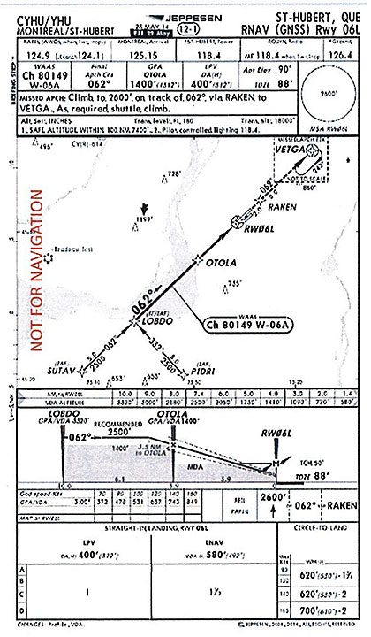
Before the descent, the PF conducted an approach briefing. Considering the surface wind direction and speed, obtained earlier in the day, the crew agreed to plan for the RNAVFootnote 3 (GNSS)Footnote 4 Rwy 06L approach (Appendix A). During the briefing, it was agreed to continue the descent during the approach until 400 feet ASL, the decision altitudeFootnote 5 published with the localizer performance with vertical guidance (LPV) procedure.
Shortly after the approach briefing, the PM switched to the designated frequency to obtain the automatic terminal information service (ATIS) information.Footnote 6 ATIS GolfFootnote 7 was as follows: weather conditions at 1000, automated observations: wind from 360° magnetic (M) at 12 knots gusting to 17 knots; visibility 9 statute miles; overcast at 11 000 feet above ground level; temperature 14 °C; dew point 9 °C; altimeter 29.68 inches of mercury; IFR approach; RNAV Runway 06L; departure and landing Runway 06R and Runway 06L. The ATIS also indicated that the first 2801 feet of Runway 24R was closed, and that the available take-off run, take-off, accelerate-stop, and landing distances were 5000 feet. The ATIS also indicated that 75 feet of the south side of Runway 06L/24R was open over a distance of 5000 feet from the Runway 06L threshold, and that 75 feet of the north side was closed along the entire length of the runway.
After listening to the ATIS, the PM communicated the information to the PF, with the exception of the dimensions (length and width) of the available runway.
Once established on final approach, the aircraft was configured for landing: the landing gear was lowered and the flaps were set at 30°. With autopilot engaged, the aircraft remained on the lateral course and vertical path generated by the flight management system.
At 1049:45, the crew called the tower controller to inform him that they were approaching initial approach fix LOBDO. The controller stated that winds were from 010°M at 16 knots gusting to 22 knots. He also asked the crew if they had read the notices to airmenFootnote 8 (NOTAMs) regarding the construction work on Runway 06L. The PM replied in the affirmative.
At 1050:51, the aircraft was cleared to land on the south side of Runway 06L. The PM read back the clearance to land on Runway 06L, but without repeating "on the south side."
Although the PF questioned the PM regarding the nature of the NOTAMs, the discussion that followed mentioned construction work with reductions to the length of the runway, but made no reference to the width of the available runway and the fact that the entire length of the north side was closed.
At 1053:51, when the aircraft was approximately 500 feet above ground level, the PF disengaged the autopilot and continued the approach manually. The aircraft was on the vertical path and aligned with what would be the centreline of the runway at full width. The PF perceived the temporary edge marking on the left side of the runway as the centreline.
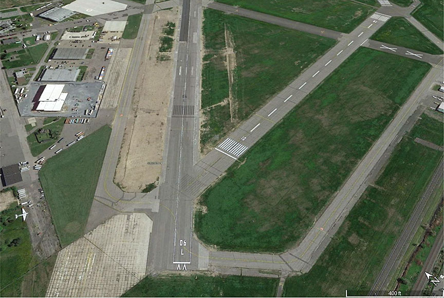
At 1054:38.5, the aircraft touched down 850 feet past the runway threshold, at which point the nosewheel was 36 feet to the left of the temporary runway centreline, i.e., 1.5 feet to the right of the temporary left edge of the runway. Therefore, the left main landing gear was about 5.2 feet outside the intended confines of the runway (Figure 1).
Once on the ground, the crew realized that the aircraft had struck something. The PF corrected the aircraft's course to the right, and the aircraft came to a stop 300 feet from the end of the runway, slightly to the right of the reduced-width runway centreline. There were no injuries.
The passenger exited the aircraft a few minutes after the occurrence and was escorted to the terminal. The aircraft and crew remained on the runway until TSB investigators arrived. The runway was closed until late that night in order for temporary repairs on the aircraft to be completed so that the aircraft could be moved.
1.2 Injuries to persons
Not applicable.
1.3 Damage to aircraft
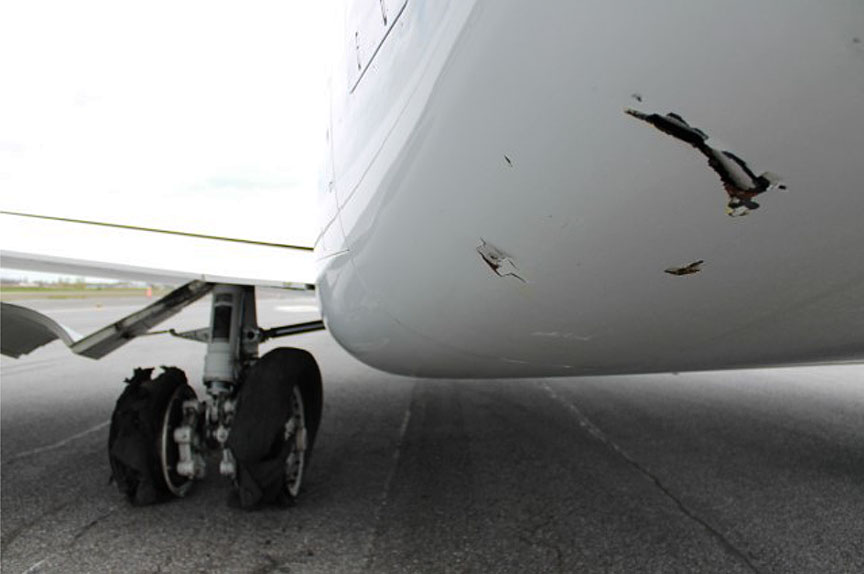
The 2 tires of the left main landing gear of the aircraft burst upon contact with the temporary runway edge lights, and the aircraft sustained substantial damage to the following areas:
- both left main landing gear wheels (Figure 2)
- the left landing gear door
- the top and bottom of the trailing edge panels of the left wing
- the left inboard flap as well as its actuating cylinder and torque tube
- the bottom of the left engine nacelle
- the rear centre fuselage, which was punctured by debris from the temporary runway edge lights (Figure 2)
Although debris from the tires was sucked into the left engine, damage was limited to 2 punctures in the acoustic panel surrounding the engine inlet area.
1.4 Other damage
Five temporary runway lights were damaged and had to be replaced. Two other lights were undamaged, although they were displaced after being struck by the aircraft.
1.5 Personnel information
1.5.1 Flight crew
Records indicate that the flight crew held the necessary licences and qualifications for the flight, in accordance with existing regulations (Table 1).
| Captain | First officer | |
| Pilot licence | Airline transport pilot certificate (ATPC) | Airline transport pilot certificate (ATPC) |
| Total flying hours | 3485 | 3305 |
| Flight hours on type | 1172 | 382 |
| Flight hours on type in the last 7 days | 15 | 15 |
| Flight hours on type in the last 28 days | 11 | 65 |
| Flight hours on type in the last 6 months | 271 | 258 |
| Hours on duty prior to the occurrence | 2.9 | 2.9 |
| Hours off duty prior to the work period | 11.5 | 11.5 |
The PF had held a U.S. airline transport pilot certificate (ATPC), with an endorsement for the BD700, since 15 November 2015. His BD700 qualification was to expire on 01 June 2017.
The PM had held a U.S. ATPC with endorsements for the BD700 and HS-125 since 24 August 2016. He had completed his qualification renewal on the BD700 as pilot-in-command on 27 March 2017.
During the 3 days before the occurrence flight, the crew had completed a total of 15 flying hours after 3 days of rest. The day of the occurrence, the crew arrived at the airport at about 0800 for the flight to CYHU. The crew had had approximately 11 hours and 30 minutes of rest and had accumulated approximately 2 hours and 55 minutes of continuous service at the time of the occurrence. There was nothing to indicate that the flight crew's performance was affected by physiological factors such as fatigue.
1.5.2 Saint-Hubert tower air traffic controller
| Licence | Air traffic controller |
|---|---|
| Medical expiry date | 01 June 2017 |
| Language proficiency assessment | Expert |
| Experience as a controller | 7 years 6 months |
| Experience in present unit | 7 years 6 months |
| Hours on duty prior to the occurrence | 3 hours 50 minutes |
| Hours off duty prior to the work period | 12 hours 50 minutes |
Records indicate that the air traffic controller on duty as the tower controller at the time of the occurrence was qualified in accordance with existing regulations. He held an air traffic controller licence issued by Transport Canada (TC) and a valid medical certificate at the time of the accident. His linguistic competence had been evaluated as expert in English and French, and he had been employed as a controller at CYHU since 2009. On the day of the occurrence, which was the controller's 3rd consecutive day of work, he had started his shift at 0705. There was nothing to indicate that the controller was fatigued at the time of the occurrence.
1.6 Aircraft information
Records indicate that the aircraft was certified, equipped, and maintained in accordance with existing regulations and approved procedures. The aircraft's weight and centre of gravity were within prescribed limits at landing.
| Manufacturer | Bombardier Aerospace |
|---|---|
| Type and model | BD-700-1A10 |
| Year of manufacture | 2002 |
| Serial number | 9071 |
| Certificate of airworthiness | 22 September 2016 |
| Total airframe time | 8941 hours / 2656 cycles |
| Engine type (number of engines) | BMW–Rolls-Royce BR 710A2-20 (2) |
| Maximum authorized takeoff weight | 93 500 pounds |
| Wing span | 93.5 feet |
| Recommended fuel type(s) | Jet A, Jet A-1, Jet B |
| Type of fuel used | Jet B |
1.7 Meteorological information
The aviation routine weather report (METAR) at 1100, approximately 5 minutes after the occurrence, was similar to the ATIS with regard to ceiling and visibility. The wind had shifted to 010° true (T) at 15 knots gusting to 20 knots. There was nothing to indicate that weather conditions contributed to the occurrence.
1.8 Aids to navigation
Due to the construction work on Runway 06L/24R, the Runway 24R instrument landing system was out of service. There is only one instrument approach published for Runway 06L: RNAV (GNSS) Rwy 06L (Appendix A). This approach, which was the one conducted by the crew on the day of the occurrence, consists of a standard vertical path of 3° with lateral guidance directly on the centreline of the runway.
The RNAV (GNSS) Rwy 06L approach allows for different minimum descent altitudeFootnote 9 options depending on the requirements of the navigation type. When the RNAV approach is conducted using the LPV, the decision altitude is established at 400 feet ASL. If only the lateral navigation (LNAV) function—which provides only lateral guidance for a profile or a flight path—is used, the minimum descent altitude is 580 feet ASL.
Due to the work being done on the runway and the displaced runway threshold, an LPV approach was not permitted, because the obstacle clearance margin requirements could not be met during an instrument approach. As stated in the Criteria for the Development of Instrument Procedures (TP 308/GPH209), "Obstacle clearance is the primary safety consideration in the development of instrument procedures."Footnote 10
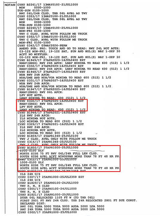
Consequently, on the day of the occurrence, a NOTAM indicated that LPV use was prohibited and that the LNAV minimum descent altitude was set at 600 feet ASL. Despite this, the occurrence flight crew conducted the approach using the LPV minima.
1.19 Communications
There was no indication that communications were disrupted for any reason. Communications between the tower controller and the flight crew were clear and were not interrupted by another radio transmission or any type of interference during the initial contact or during the landing clearance.
Although the Canadian Aviation Regulations (CARs) do not specifically require pilots to read back landing clearances, section 602.31 of the CARs indicates, among other things, that the pilot-in-command is required during IFR flight to "read back to the […] air traffic control unit the text of any […] clearance received […]."Footnote 11 In this occurrence, when the tower controller authorized N888ZJ to land on the south side of Runway 06L, the PM read back the authorization to land without repeating "on the south side." Neither of the pilots questioned the details of the information received with the landing clearance, nor was the incomplete readback challenged by the controller.
The NAV CANADA Manual of Air Traffic Services contains information on procedures for air traffic services personnel. Regarding ensuring accuracy, the Traffic Management section states the following:
Footnote 12The NAV CANADA manual VFR PhraseologyFootnote 13 is a phraseology learning tool and reference guide for all pilots using Canadian airspace. The manual states that "[r]eading back instructions as well as clearances allows both you and ATS to correct any mistakes in what has been said and heard."Footnote 14
Although the manual applies to visual flight rules flight, it lists landing clearances as one of the most safety-critical clearance types that may be read back.Footnote 15
1.10 Aerodrome information
1.10.1 General
The non-profit corporation Développement Aéroport Saint-Hubert de Longueuil (DASH‑L) is responsible for the management, operation, and development of CYHU. As the holder of an airport certificate, DASH-L has implemented a TC-approved safety management system.
CYHU has 3 asphalt runways:
- Runway 10/28, which is 2791 feet long and 150 feet wide;
- Runway 06R/24L, which is 3922 feet long and 100 feet wide; and
- Runway 06L/24R, which is 7801 feet long and 150 feet wide.
On the day of the occurrence, the dimensions of Runway 06L/24R were reduced to 5000 feet long by 75 feet wide due to construction work. In addition, the normally displaced threshold of Runway 06L had been moved 1105 feet, placing it near where the asphalt surface began.
1.10.2 Construction work underway
The construction work underway at the time of the occurrence consisted of repairs to Runway 06L/24R and taxiways M and R, and part of Taxiway C. According to the Plan d'exploitation durant une construction (PEC) 2017, operations during this construction work were conducted in accordance with the standards specified in the 4th edition of TC's TP 312,Footnote 16 other than the marking, which was to be executed in accordance with the 5th edition of TP 312.Footnote 17 Footnote 18 Work was to be completed by 31 October 2017.
1.10.3 Plan d'exploitation durant une construction (PEC) 2017
The Plan d'exploitation durant une construction (PEC) 2017 was approved by TC on 21 April 2017. According to the PEC schedule, there were 4 phases of work. Phase 2, which was underway at the time of the occurrence, had started on 15 April 2017 and was scheduled to last until 15 July 2017. During this phase, Runway 06L/24R was open with certain restrictions from 0600 to 2100, and was closed from 2100 to 0600.
Two of the 11 risks that had been analyzed in the risk management plan appended to the PEC were
- insufficient light in the morning and evening on Runway 06L/24RFootnote 19 ; and
- operating Runway 06L/24R with a reduced width of 75 feet and a relocated threshold, leaving 5000 feet of operational runway.Footnote 20
In regard to the risk associated with insufficient light in the morning and evening, 3 risk mitigation measures had been implemented [translation]:
- Add a temporary lighting system, activated and deactivated daily. […]
- If needed, and in consultation with users, restrictions can be implemented (by NOTAM or otherwise), with assistance from NAV CANADA, to limit aircraft movements […].
- Close Runway 06L/24R at night from 2100 to 0600 to eliminate the risk of night operation accidents following failure of temporary lighting systems. This also allows the batteries to be recharged at night.Footnote 21
For the risk associated with operating a runway with a reduced width of 75 feet and a relocated threshold, resulting in a runway length of 5000 feet, 13 risk-mitigation measures had been considered, 8 of which applied to runway markings [translation]:
- During the day and at night, clearly define the part of the runway in operation to distinguish it from the closed portion of the runway.
- The runway side stripe edge markings for a 23 m wide runway are 450 mm wide.
- At night, when the runway is in operation, the runway edges will be indicated by runway edge lights […].
- Add markings for relocated threshold […], including arrows in the pre-threshold area […].
- Install Transport Canada–approved threshold lights and runway end lights.
- Install illuminated Xs at each end of the existing runway. Activate illuminated Xs when the runway is completely closed, i.e., from 2100 to 0600.
- Xs will be added on the ground to indicate the portion of the runway (full width) closed to flight operations. No Xs on the ground for the half of the runway width closed to flight operations.
- Turn off Runway 06L threshold PAPIs [precision approach path indicators] and install temporary PAPIs at relocated threshold of Runway 06L […].Footnote 22
The PEC 2017 stipulated that Runway 06L/24R was restricted to aircraft with a wingspan of less than 24 m (approximately 78 feet), unless authorization was obtained 48 hours in advance from airport management.Footnote 23 Operators were to submit to DASH-L [translation] "a risk-management plan with mitigation measures specific to operations [on this runway]."Footnote 24 Given that the BD-700-1A10 has a wingspan of 28.5 m (approximately 93.5 feet), authorization from the airport operator was required. This requirement was indicated in the NOTAM that the flight crew had in their possession.
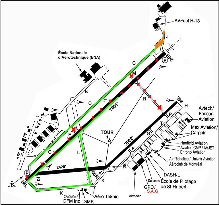
When an air operator submitted a request, DASH-L provided a user form that included a detailed description of the works, including photos and a diagram of the airport with red Xs showing the closed side of the runway and a green line showing the south side of the runway that was usable (Appendix B). The diagram did not provide any information on the dimensions of the usable runway. The number 7801 at the end of the green line indicated the normal length of the runway.
By reading and signing the user form, the operator agreed to use the airport under the conditions listed. There was nothing to indicate that Zetta Jet USA Inc. had submitted such a request or contacted DASH-L.
1.10.4 Temporary marking
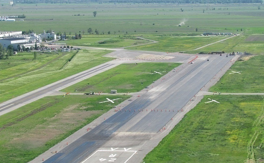
The temporary marking due to construction included an unbroken white line on each side and end of the runway to form a rectangle 75 feet wide by 5000 feet long around the south side of Runway 06L that was usable for landing, as specified in the PEC (Figure 3). The runway number was painted in white at the threshold of the part of the runway usable for landing, and 2 arrows, also painted in white, were placed just before the runway threshold, indicating the landing direction. The original painted touchdown zone and runway centreline markings were still visible, and the temporary left runway edge line overlapped the original runway centreline markings. As specified in the PEC,Footnote 25 there were no Xs on the ground for the closed half of the runway width.
Orange cones had been placed after the end of the runway, across its entire width, to separate the part that was usable for landing from the closed portion of the Runway 24R threshold, where the construction equipment was located. In addition, 2 white Xs had been placed on each side of the last 2801 feet of Runway 06L; the entire width of this portion was closed (Figure 4).
1.10.5 Temporary solar lighting
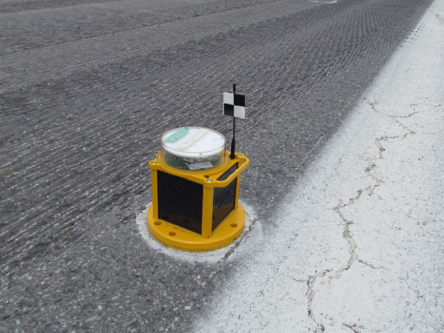
Despite the NOTAM indicating that Runway 06L/24R of CYHU was closed at night, temporary runway edge lights had been placed near each of the white lines delimiting the runway edges (Figure 5). These lights were not on at the time of the occurrence, and there was no requirement for them to be on.
During the day, when the lights are off, they are difficult to see during final approach. It was only once the occurrence flight crew was on the ground that they realized that the temporary runway edge lights were there. With the exception of the temporary PAPI on the left side of the displaced runway threshold, there was no other lighting activated at the time of the occurrence, and there were no requirements for such lighting.
The temporary lighting system was activated from 0600 until at least 30 minutes before sunrise, and reactivated 30 minutes after sunset, until 2100.
The PEC stipulates that [translation]
Footnote 26 Footnote 27Furthermore, section 5.3.10.11 of TP 312 states that "[r]unway edge lights shall be fixed lights,"Footnote 28 and section 5.3.10.16 states that "[r]unway edge light mountings shall be frangible."Footnote 29
However, the temporary lights were not properly secured to the ground such that they were frangible. They were simply placed along the runway side stripe markings on each side of the runway, because they sometimes had to be moved to make way for vehicles. There was no NOTAM issued to indicate the presence of these temporary lights.
1.10.6 Transport Canada standards
According to the applicable requirements of aerodrome certification, which are found in Part III, Subpart 2, of the CARs,
302.07 (1) The operator of an airport shall
- comply
- subject to subparagraph (ii), with the standards set out in the aerodrome standards and recommended practices publications, as they read on the date on which the airport certificate was issued […].Footnote 30
The recommended standards and practices contained in TP 312
Footnote 31According to section 5.2.24.1 of the 5th edition of TP 312, applicable to closed or unserviceable-area marking,
Footnote 32However, section 5.2.24.2 states the following:
Footnote 33 Footnote 34Furthermore, regarding centreline markings, the following sections emphasize that
5.2.8.1 A runway centreline marking is provided on a paved runway.
5.2.8.2 Subject to 5.2.1.3, the runway centreline marking is located along the centreline of the runway between the runway designation markings.Footnote 35
In this occurrence, because the operator had opted to disseminate the construction information by NOTAM, markings for closed or unusable zones had not been placed on the runway. Furthermore, contrary to the standards in TP 312, the reduced-width runway did not have centreline markings.
1.11 Flight recorders
The aircraft was equipped with a cockpit voice recorder (CVR) and a digital flight data recorder (DFDR). Both recorders were removed from the aircraft and sent to the TSB Engineering Laboratory, where their data were recovered and analyzed.
The DFDR contained 27 hours of data, including the data of the occurrence flight. An analysis of this data made it possible to determine the speed of the aircraft, its precise path, the exact point at which the main landing gear touched down, the PF's use of the flight controls, and the activation of various manual and automatic systems.
1.12 Wreckage and impact information
Not applicable.
1.13 Medical and pathological information
Not applicable.
1.14 Fire
Not applicable.
1.15 Survival aspects
Not applicable.
1.16 Tests and research
1.16.1 Federal Aviation Administration Airport Construction Advisory Council
In April 2010, the Air Traffic Organization of the U.S. Federal Aviation Administration created the Airport Construction Advisory Council (ACAC),Footnote 36 which is responsible for finding ways to mitigate the risks of construction work at airports.
According to the ACAC, the following factors are often identified as causes of safety-related occurrences during airport construction: ATIS information, NOTAMs, visual cues, air traffic controller phraseology, and airport diagrams and charts.Footnote 37 The ACAC details these causal factors as follows:
ATIS: The ATIS broadcast at large airports often contains a significant amount of information besides airport construction data. Construction NOTAMs have sometimes blended in with the background information and are not absorbed and recognized by pilots. In other cases, the ATIS does not include declared distances and other critical construction-related information.
NOTAMs: Large airports frequently have a significant number of NOTAMs in place, especially during times of airport construction. This can lead to information being overlooked by the people who really need it: pilots, dispatchers and air traffic controllers. Also, the information contained in NOTAMs sometimes elude an operator's memory just when it is most needed—during the takeoff or landing phases of flight when information saturation and risk tends to reach a peak. Also, the NOTAM format (all capital letters and infrequently used abbreviations) is often awkward to interpret or subject to misunderstanding.
Visual cues: Airport signage, taxiway and runway markings, and other visual cues can help or hinder flight crews as they attempt to distinguish closed surfaces from active ones. Lack of visual cues has contributed to aircraft operating on closed surfaces, and to wrong runway departures and arrivals.
Controller phraseology: Controller phraseology can sometimes lead to ambiguity or mistaken conclusions about the actual condition and specifications of the surfaces impacted by construction.
Airport diagrams and charts: Airport diagram publications often lag behind construction closures and sometimes are not updated at all during an airport construction project. Operators must "connect the dots" between such diagrams and the NOTAM content to get an actual assessment of the pavement they are using.Footnote 38
1.16.2 Flight Safety Foundation
An article published in AeroSafety World indicates that "[o]perating aircraft near runway/taxiway construction projects adds extraordinary complexity for everyone involved."Footnote 39
According to the article, "Sometimes people knew about the NOTAM at one point and later forgot; on other occasions, they simply never knew about the construction NOTAM at all."Footnote 40
1.16.3 Construction notices in the United States
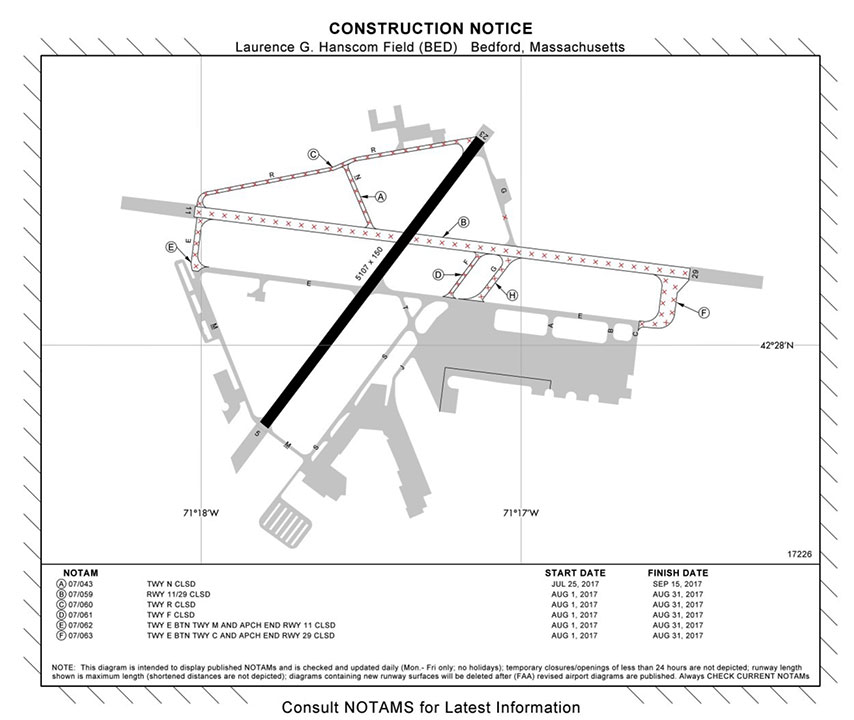
The Federal Aviation Administration publishes construction notices on its website.Footnote 41 A verificationFootnote 42 of these construction notices identified 55 U.S. airports with construction activities. Each of the notices contained a diagram of the airport with a red X clearly showing the closed portion of the runway or taxiway (Appendix C). None of the 55 airports was undergoing construction that resulted in the entire length of one side of a runway being closed. No similar webpage exists in Canada.
1.16.4 TSB laboratory reports
The TSB completed the following laboratory report in support of this investigation:
- LP189/2017 – FDR [flight data recorder] Download & Analysis
1.17 Organizational and management information
At the time of the occurrence, Zetta Jet USA Inc. offered personalized, on-demand, worldwide service. However, as of 30 November 2017, the company had ceased operations and surrendered its operating certificate to the Federal Aviation Administration. It was founded in 2015, and was based in Singapore. It had an operating base in Burbank, California, and a fleet of 21 aircraft: 1 Beechcraft B200, 13 Bombardier BD-700s, 1 Canadair CL-600, 5 Gulfstream GA-IVs, and 1 Gulfstream GA-V.
The flight in question had been conducted in accordance with Part 135 of the U.S. Federal Aviation Regulations. The company also held a Canadian Foreign Air Operator Certificate, issued by TC under Subpart 701 of the CARs.
The company had developed a safety management system to mitigate its operating risks by expanding and revising its processes and procedures.
1.18 Additional information
1.18.1 Similar occurrences
1.18.1.1 Montréal/St-Hubert Airport
Between 15 August 2016 (the day construction work began) and the day of the occurrence, NAV CANADA produced 6 detailed aviation occurrence reports and submitted them to the TSB following similar incidents at CYHU, as well as this occurrence. Five of these occurrencesFootnote 43 were reportable under the Transportation Safety Board Regulations.Footnote 44
In 4 of these incidents, the aircraft struck temporary runway lights during either takeoff or landing. There were no injuries. With the exception of this occurrence, the aircraft involved in these occurrences did not sustain major damage.
From the date of this occurrence until 14 August 2017, there were 4 occurrences at CYHU. Of these 4 occurrences, only 1 was reportable (TSB Aviation Occurrence A17Q0079). The 4 occurrences involved 2 aircraft that travelled on the closed side of the runway and 2 aircraft that landed on Taxiway C, despite being cleared to land on the south side of Runway 24R. There were no injuries, and none of the aircraft sustained damage.
1.18.1.2 Iqaluit Airport
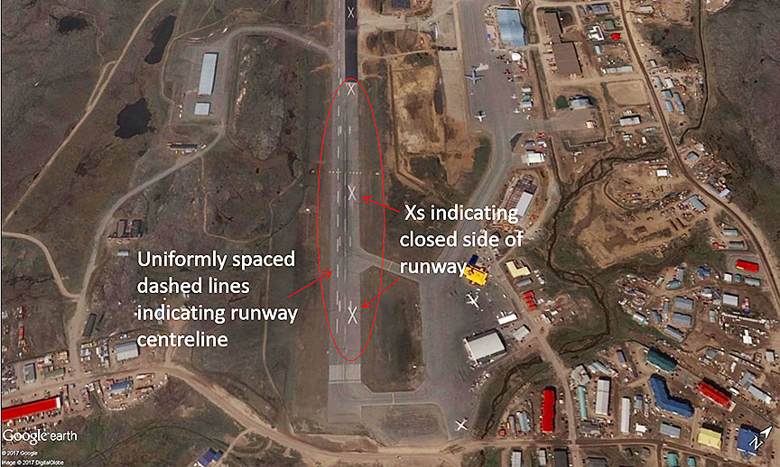
In 2015, Iqaluit Airport (CYFB), Nunavut, underwent work similar to the work at CYHU. The width of the runway was reduced along the entire length of the runway. White Xs indicated the closed side of the runway, and the centreline of the runway had been marked with uniformly spaced dashed lines (Figure 6).
Although the marking was different at CYFB, there were 2 incidentsFootnote 45 involving runway edge lights being struck during construction, on 08 and 11 July 2015. In both of these cases, a Boeing 737-200 was conducting an IFR flight to CYFB. Because of the construction work, half of the entire length of the runway at CYFB had been closed by means of a NOTAM. Temporary lights were placed along the edge of the runway, uniformly spaced dashed lines indicated the runway centreline, and Xs had been placed along the entire length of the closed portion of the runway.
On final approach to Runway 16, the flight crews did not see the marking indicating the closed portion of the runway, nor did they notice the presence of temporary runway lights. In both cases, the aircraft struck a number of temporary runway lights on landing and sustained minor damage. There were no injuries.
1.18.1.3 Notices to airmen
The Canadian NOTAM Procedures Manual states the following:
1.1.2 Definition of NOTAM
A NOTAM is a notice distributed by means of telecommunications containing information concerning the establishment, conditions or change in any aeronautical facility, service, procedure or hazard, the timely knowledge of which is essential to personnel concerned with flight operations.
1.1.3 Purpose of NOTAM Distribution
The basic purpose of NOTAM is the distribution of information that may affect safety and operations in advance of the event to which it relates, except in the case of unserviceable facilities or unavailability of services and activities that cannot be foreseen. Thus, to realize its purpose the addressee must receive a NOTAM in sufficient time to take any required action. The value of a NOTAM lies in its "news content" and its residual historical value is therefore minimal.Footnote 46
NOTAMs for Canadian airports are produced and published by NAV CANADA based on information provided by aerodrome operators. NAV CANADA's Canadian NOTAM Procedures Manual is based on International Civil Aviation Organization (ICAO) standards.Footnote 47 Footnote 48 Footnote 49
According to the Canadian NOTAM Procedures Manual, a "NOTAM shall be as brief as possible, stating only the essential factsFootnote 50 and so compiled that its meaning is clear and unambiguous. Clarity shall take precedence over conciseness."Footnote 51 A NOTAM must be issued when the width of a runway is reduced. The examples cited in the manual for a reduction in width include information about the runway in question, the closed portion and its orientation, the width of the available portion, and the authorized wingspan of an aircraft. The examples do not use terms or acronyms to designate a reduced-width condition.
For a reduction in length, the examples cited do not use terms or acronyms to designate a reduced-length condition. Instead, they use abbreviations of the distance available for takeoff or landing. NAV CANADA issues NOTAMs for reductions in length more frequently than it does NOTAMs for reductions in width. NOTAMs can also be issued to indicate a change in runway edge lighting.
Canadian NOTAMs are composed mainly of abbreviations and acronyms that must be interpreted in order to understand the NOTAMs' contents. According to Appendix C of the Canadian NOTAM Procedures Manual, there are 336 abbreviations and acronyms.
As specified in the Zetta Jet USA Inc. General Operations Manual, one of the pilot-in-command's tasks and responsibilities is to obtain a briefing before departure. This briefing includes the NOTAMs.Footnote 52 The manual also states that pilots must ensure that the applicable NOTAMs for each flight segment are attached to the computer-generated flight plan or are with the weather information.Footnote 53
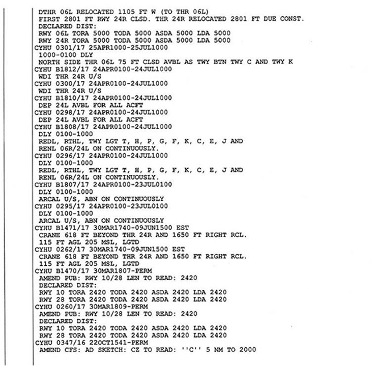
In this occurrence, before departure, the flight crew had obtained a copy of the NOTAMs applicable to the flight. The copy attached to the flight plan included a total of 121 NOTAMs, including 37 concerning CYHU. Of these 37 NOTAMs,Footnote 54 9 concerned Runway 06L, including 1 about the displaced threshold of Runway 06L, 1 about the length of runway available for landing, and 1 regarding the reduction in width of Runway 06L (Appendix D). These NOTAMs were written in accordance with the Canadian NOTAM Procedures Manual.
Of the 37 NOTAMs regarding CYHU, 8 were related to airfield construction, and the NOTAM on the runway width reduction was the 16th on the list. The same NOTAM indicated that, for aircraft with a wingspan greater than 78 feet, 48 hours' notice was to be given to airport authorities. N888ZJ's wingspan was greater than 78 feet, so this NOTAM applied. However, as stated in Section 1.10.3 of this report, there is nothing to indicate that such a notice was provided to CYHU airport authorities. The information gathered indicates that the flight crew incorrectly believed that only the length of the runway, and not the width, had been reduced.
As specified in Section 1.16.2 of this report, people sometimes forget information contained in a NOTAM or are unaware that a NOTAM regarding construction work exists.
For example, on 01 September 2013, a Boeing 737-200 was conducting an IFR flight from Ottawa/Macdonald-Cartier International Airport (CYOW), Ontario, to CYFB.Footnote 55 The threshold of CYFB's Runway 35 had been moved 1900 feet during repair work. Two white Xs had been placed outside the left edge of the runway along the length of the closed portion, and low-profile barricades had been installed to indicate the position of the displaced runway threshold. When landing on Runway 35, the aircraft touched down on the portion of runway that had been closed by means of a NOTAM, which had been transmitted and broadcast on the aeronautical fixed telecommunications network (AFTN)Footnote 56 for over 12 hours. The crew had not read this NOTAM when planning the flight. During the landing roll, the main landing gear passed between 2 barricades without touching them and continued on the usable portion of the runway without issue. The aircraft was not damaged.
Section 417.5 of the NAV CANADA Flight Services Manual of Operations (FS MANOPS), in force at the time of the occurrence mentioned above,stipulates the following for flight service specialists: "Issue appropriate NOTAM information that may affect the arrival or departure of an aircraft."Footnote 57
However, section 417.6 of the FS MANOPS includes the following information:
Specialists working at an FSS [flight services station] may omit providing NOTAM information that has been issued and disseminated on AFTN for:
- 12 hours or more for domestic traffic […]Footnote 58
Since the NOTAM had been broadcast on the AFTN for more than 12 hours, the flight service specialist was not required to notify the flight crew. It was only when the aircraft was approximately 50 feet above the ground that the CYFB flight service specialist attempted to inform the flight crew of the NOTAM that was in force, after realizing that there was a risk of collision with the barricades.
1.18.3 Flight preparation
Zetta Jet USA Inc.'s General Operations Manual indicates that the pilot-in-command is responsible for determining whether the airports intended for use are suitable and adequate, taking into account take-off and landing conditions, such as the length and width of the runway. According to the manual, tasks related to the preparation of a flight include the following:
- Familiarization with airport data to include runway length, available approaches, and applicable noise curfews and noise abatement procedures.
- Familiarization with weather information for departure, enroute, arrival, and, if required, alternate airports. This information will include, but is not limited to, current weather reports, weather forecasts, and NOTAMs.Footnote 59
In this occurrence, the flight crew had all of this information before departing KTEB and had read it. However, the investigation was unable to determine when the flight crew had reviewed the relevant information, including the NOTAMs pertaining to the construction work on CYHU's Runway 06L/24R.
1.18.4 Preparation for approach and landing
As indicated in Section 1.1 of this report, the PF had conducted the approach briefing specified in the General Operations Manual.However, he did not use the acronym "NATS"Footnote 60 specified in the manual.Footnote 61 This acronym helps with memorizing the points to be covered during the approach briefing. The letter "N" is to remind the crew to discuss NOTAMs. In this occurrence, there was no discussion of NOTAMs during the approach briefing.
1.18.5 Situational awareness and mental models
Situational awareness (SA) is based on the perception of elements in the environment, the comprehension of their meaning, and the projection of a mental model to anticipate the future. The most widely used SA modelFootnote 62 has 3 distinct levels, and states that effective performance requires crews to
- perceive information in the operating environment (Level 1 SA);
- comprehend the significance of this information to the current situation (Level 2 SA); and
- use this information to anticipate future states (Level 3 SA).Footnote 63
Problems can occur at any of the 3 levels, leading to situations where critical information is not perceived, the current situation is misunderstood, or situations are not anticipated.
SA is developed and maintained through a continual process of situational reassessment: SA is affected by the air crew's goals and expectations, experience, and a number of other factors that influence how attention is directed, how information is perceived and how it is interpreted.Footnote 64
A mental model is an internal structure that makes it possible for people to describe, explain, and predict events and situations in their environment.Footnote 65 When a mental model is adopted, it is resistant to change. Convincing new information must be absorbed to modify a mental model. An inaccurate mental model will interfere with the perception of critical elements or comprehension of their importance.Footnote 66
1.19 Useful or effective investigation techniques
Not applicable.
2.0 Analysis
2.1 Introduction
The flight crew held the necessary licences and qualifications for the flight, in accordance with existing regulations. There is nothing to indicate that physiological factors such as fatigue degraded their performance.
The flight crew possessed the information regarding the construction work on Runway 06L/24R that reduced the width and length of the available runway by means of notices to airmen (NOTAMs) and the automatic terminal information service (ATIS) information. When asked by the controller, before the aircraft was cleared to land on the south side of Runway 06L, the pilot monitoring (PM) also acknowledged having read the NOTAMs about the construction work,. Despite this, the aircraft landed partially outside the intended confines of Runway 06L, such that the left main landing gear struck temporary runway edge lights. Therefore, this analysis will focus on the flight crew's situational awareness, flight planning, approach and landing preparation, markings of runways under construction, and the conciseness and clarity of the NOTAMs.
2.2 Situational awareness
Situational awareness is based on the knowledge of elements in the operating environment, the comprehension of their meaning, and the projection of a mental model to anticipate the future. In this occurrence, the flight crew shared a mental model in which only the length of the runway was reduced.
Although reductions in width occur much less frequently than reductions in length, information was available for the flight crew to correct their mental model: the information contained in the NOTAMs, the ATIS, and the clearance to land on the south side of the runway. As well, the runway number was painted in white on the threshold of the part of the runway that was usable for landing, and there were 2 arrows indicating the landing direction, also painted in white, just before the runway threshold. However, this information does not seem to have been compelling to or absorbed by the flight crew, and they adopted a mental model that was resistant to change and to the apprehension of elements that are critical to a safe landing.
This mental model of the runway being reduced only in length was reinforced by the following circumstances:
- The original touchdown zone and runway centreline markings were still present.
- There were no runway centreline markings for the reduced-width runway.
- There were Xs at the end of the runway but no Xs on the north side of the runway.
The aircraft followed the published approach and was therefore aligned with the usual runway centreline, which was the temporary side stripe marking along the left edge of the runway. That line was perceived as the runway centreline. Furthermore, it would have been nearly impossible, especially in an unexpected situation, to see the unlit temporary runway lights that were placed near the runway side stripe markings to indicate the left runway edge.
Despite the NOTAMs, ATIS information, and communication with the controller, the flight crew incorrectly believed that the entire width of the runway was available.
Before landing, the crew misinterpreted the runway markings, and the pilot flying (PF) perceived the runway side stripe marking indicating the left edge of the runway as the runway centreline. As a result, the aircraft touched down partly outside the limits of the intended runway and struck 7 temporary runway edge lights.
2.3 Flight planning
Flight planning requires a crew to analyze several elements in order to detect the potential threats associated with a flight and determine their impact on the safety of the flight. Thorough flight planning is therefore a first line of defence against the potential threats that can be encountered during a flight.
In this occurrence, the construction work on Runway 06L at Montréal/St-Hubert Airport (CYHU) reduced the runway width to 75 feet and the length to 5000 feet, which affected the instrument approach minima. The construction constituted a threat to which the flight crew was exposed. Furthermore, obstacles on the ground, such as temporary runway lights, orange cones, and equipment, were located near the landing area, creating a risk of collision with these obstacles.
The information regarding the dimensions of Runway 06L was available and had been provided to the flight crew before their departure by means of NOTAMs. Although the flight crew read the NOTAMs before they departed, the investigation was unable to determine when the crew had reviewed them for the purposes of interpretation.
In addition, one of the NOTAMs indicated that, for aircraft with a wingspan greater than 78 feet, 48 hours' notice was to be given to airport authorities in order to use Runway 06L/24R. When a notice was submitted to the airport authorities, Développement Aéroport Saint-Hubert de Longueuil (DASH-L) would issue an authorization form with photos and diagrams of Runway 06L/24R, which would provide flight crews with a visual representation of the construction work and the closed movement areas.
There is nothing to indicate that the company or flight crew of the occurrence aircraft, which had a wingspan exceeding 78 feet, submitted a notice to DASH-L 48 hours in advance.
In this occurrence, the flight planning did not adequately prepare the crew to ensure a safe landing at CYHU.
2.4 Approach and landing preparation
Approach and landing preparation is conducted before the descent is begun. Preparation for the instrument approach to CYHU consisted of listening to the ATIS, programming the flight management system for the approach, completing the pre-descent checklist, and conducting an approach briefing.
Zetta Jet USA Inc.'s General Operations Manual specifies what an approach briefing should contain, and in this case the manual constituted a second line of defence against the threat to which the flight crew was exposed. Although the PF had conducted an approach briefing, he did not use the acronym "NATS" as a memory aid for the points to be discussed during an approach briefing. Given that the letter "N" reminds the crew to discuss or review the NOTAMs, the use of the acronym might have prompted the crew to reread the NOTAMs.
In addition, the letter "A" reminds the crew to review the key points of an approach, such as the minimum descent altitude (MDA) and the decision altitude (DA). Therefore, rereading the NOTAMs could have enabled the crew to correct the MDA to 600 feet above sea level (ASL) rather than to a DA of 400 feet ASL. The use of the localizer performance with vertical guidance for the approach was not authorized, because the threshold of Runway 06L, normally displaced by 1105 feet, had been relocated due to the ongoing construction work. In this case, the fact that the crew had set a lower approach minimum did not play a role in the occurrence. If flight crews conduct incomplete approach briefings, there is a risk that information that is crucial to the safety of the flight will be missed.
The ATIS indicated the dimensions of Runway 06L and the fact that the entire length of the north side was closed. Although the PM had listened to ATIS Golf before the descent, he did not share all of the information with the PF: he omitted the information indicating that the entire length of the north side of Runway 06L was closed and that only 75 feet of the width, on the south side, was available for landing. The investigation was unable to determine why this crucial piece of information was not shared with the PF.
For an unknown reason, the PM neither absorbed nor shared the ATIS information indicating that the runway width was reduced to 75 feet and that only the south side of the runway was available for landing.
Among the causal factors observed in occurrences associated with construction work at airports, the Airport Construction Advisory Council (ACAC) notes that controller phraseology sometimes leads to ambiguity or erroneous conclusions regarding the actual state and specifications of the surfaces affected by the work. In this occurrence, the tower controller asked the flight crew if they had read the NOTAMs regarding the construction work. Given that the crew responded in the affirmative, it was reasonable for the tower controller not to mention the details of the NOTAMs, and more specifically those pertaining to the dimensions of the runway.
Moreover, in the landing clearance, the controller gave the instruction to land on the south side of the runway. However, the PM read back only part of the landing clearance, omitting the instruction to land on the south side. The controller did not question the incomplete readback of the clearance to land on the south side. The crew continued the landing, incorrectly believing that the full width of the runway was available for the landing.
2.5 Marking of runways under construction
Airport construction is known to introduce additional risks for air operators. Several factors are often identified as causes of occurrences during periods of construction work at airports, including ATIS, NOTAMs, visual cues, the phraseology used by air traffic controllers, and airport diagrams.
As noted by the ACAC, signage, runway markings, and other visual cues can help or hinder flight crews when they attempt to distinguish closed surfaces from active zones. Lack of visual cues is known to have contributed to past occurrences in which aircraft travelled on closed surfaces and took off or landed using the wrong runway.Footnote 67
When people are expecting a situation, they are at risk of overlooking cues that indicate that the situation is not what it should be. In order to recognize that a change in plan is required, and in order to react in time, pilots must perceive the condition or stimulus as sufficiently important, such that they react immediately.
This was the case in the 2 occurrences in 2015 at Iqaluit Airport (CYFB), Nunavut, during runway construction work that reduced the width of the runway along its entire length. However, in both of these cases, Xs had been placed along the entire length of the closed side of the runway, and uniformly spaced dashed lines indicated the temporary runway centreline. There was no explanation as to why the flight crews did not recognize the meaning of the markings. In both cases, it is plausible that, once the flight crews saw the runway, the stimulus was not sufficiently important to allow them to react in time.
In this occurrence, when the flight crew had the runway in sight, the markings of Runway 06L did not prompt the realization that the north side of the runway was closed: there were no Xs on the closed portion; the original touchdown zone and runway centreline markings were still visible; the temporary runway lights placed near the runway side stripe markings were not visible from a distance; and the flight crew interpreted the side stripe marking indicating the left edge of the runway as the centreline. As a result, the flight crew did not realize that they were landing the aircraft on a closed portion of the runway.
Moreover, the temporary runway edge lights were not properly secured such that they were frangible, as specified in the Plan d'exploitation durant une construction (PEC) 2017,Footnote 68 nor were they fixed as specified in section 5.3.10.11 of TP 312.Footnote 69 As a result, when the main wheels of the left side of the aircraft struck the lights, the lights were displaced, damaged the rear fuselage, and caused the tires to burst. Debris from the tires also damaged the rear fuselage. If temporary runway edge lights are not properly secured, there is a risk that they will be displaced and damage aircraft during landings or takeoffs.
2.6 Conciseness and clarity of notices to airmen
Each NOTAM addresses one topic and one condition at a time. Since there may be many NOTAMs for one flight, each NOTAM must be as concise as possible, as well as clear and unambiguous. Although abbreviations and acronyms are used to make NOTAMs concise, they are complex to decipher, which can make the NOTAMs unclear and lead to ambiguity when they are consulted. As well, given that flight crews sometimes have several NOTAMs to consult during flight planning, they may simply skim or forget some.
The NOTAM regarding the reduction in width of Runway 06L/24R indicated that 75 feet of the north side of the runway was closed along its entire length. This NOTAM was in accordance with NAV CANADA's Canadian NOTAM Procedures Manual. The NOTAM mentioned the condition without clearly indicating the reduction in width. This was also the case for the 2 occurrences at CYFB in 2015.
Reductions in runway width are not as common as reductions in runway length. Therefore, the use of the words "reduced width," in a NOTAM for a runway width reduction, would clearly identify the condition and reduce the risk of ambiguity.
3.0 Findings
3.1 Findings as to causes and contributing factors
- Despite the notices to airmen (NOTAMs), the automatic terminal information service (ATIS) information, and communication with the controller, the flight crew incorrectly believed that the entire width of the runway was available.
- Before landing, the crew misinterpreted the runway markings, and the pilot flying perceived the runway side stripe marking along the left edge of the runway as the runway centreline. As a result, the aircraft touched down partly outside the limits of the intended runway and struck 7 temporary runway edge lights.
- In this occurrence, the flight planning did not adequately prepare the flight crew to ensure a safe landing at Montréal/St-Hubert Airport.
- For an unknown reason, the pilot monitoring neither absorbed nor shared the ATIS information indicating that the runway width was reduced to 75 feet and that only the south side of the runway was available for landing.
- The controller did not question the incomplete readback of the clearance to land on the south side. The crew continued the landing, incorrectly believing that the full width of the runway was available for the landing.
- The flight crew did not realize that they were landing the aircraft on a closed portion of the runway.
3.2 Findings as to risk
- If flight crews conduct incomplete approach briefings, there is a risk that information that is crucial to the safety of the flight will be missed.
- If temporary runway edge lights are not properly secured, there is a risk that they will be displaced and damage aircraft during landings or takeoffs.
3.3 Other findings
- The occurrence aircraft, which had a wingspan exceeding 78 feet, was required to submit a notice to Développement Aéroport Saint-Hubert de Longueuil 48 hours in advance. There is nothing to indicate that the company or flight crew of the occurrence aircraft did so. If they had, they would have received a diagram of Runway 06L/24R, which would have provided the flight crew with a visual representation of the construction work and the closed movement areas.
- The use of the words "reduced width," in a NOTAM for a runway width reduction, would clearly identify the condition and reduce the risk of ambiguity.
4.0 Safety action
4.1 Safety action taken
4.1.1 Développement Aéroport Saint-Hubert de Longueuil
After this occurrence, Développement Aéroport Saint-Hubert de Longueuil added a popup window to its website. This message appeared when the website was accessed and contained a message describing the construction work. The message specified that flight crews must read the notices to airmen (NOTAMs) in effect at the airport. Crews could download a diagram of the construction work.
This report concludes the Transportation Safety Board of Canada's investigation into this occurrence. The Board authorized the release of this report on . It was officially released on .
Appendices

