Controlled flight into terrain
Piper PA-46-350P, N757NY
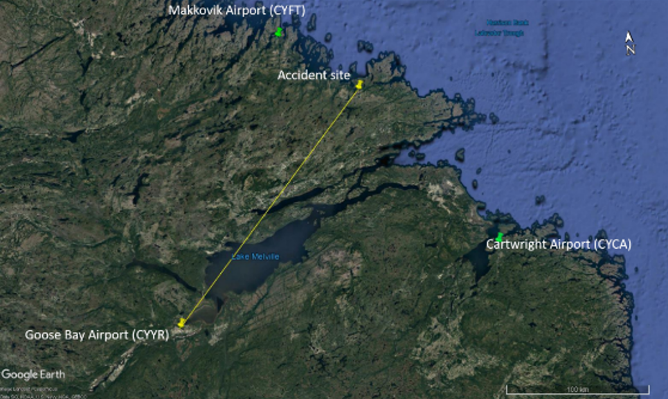
Makkovik Airport, Newfoundland and Labrador, 35 NM SE
The Transportation Safety Board of Canada (TSB) investigated this occurrence for the purpose of advancing transportation safety. It is not the function of the Board to assign fault or determine civil or criminal liability. This report is not created for use in the context of legal, disciplinary or other proceedings. See Ownership and use of content. Masculine pronouns and position titles may be used to signify all genders to comply with the Canadian Transportation Accident Investigation and Safety Board Act (S.C. 1989, c. 3).
Background
The privately registered Piper PA-46-350P aircraftFootnote 1 (registration N757NY, serial number 4636657) was purchased in the United States (U.S.) by a partnership of 2 pilots from the United Kingdom (UK). The co-owners hired a ferry pilot to deliver the aircraft overseas to the UK with one of them on board.
The ferry pilot and the co-owner arrived separately in Norfolk, Virginia, U.S., on 29 April 2019. They met the following day and took delivery of the aircraft. Later that day, they departed Norfolk International Airport (KORF) and flew uneventfully to Sept-Îles Airport (CYZV), Quebec, under instrument flight rules (IFR). They departed CYZV shortly after on a visual flight rules (VFR) flight plan to Goose Bay Airport (CYYR), Newfoundland and Labrador. Due to weather as the flight progressed, they converted to an IFR flight for the remainder of the flight.
On 01 May 2019, the day of the occurrence, in preparation for the flight to Narsarsuaq Airport (BGBW), Greenland, a weather package was provided to the pilots, which indicated significant headwinds and rough air aloft along the intended route. The ferry pilot was familiar with the route and the intent was to depart on a VFR flight plan, to manoeuvre around weather and terrain while remaining clear of clouds, and then to climb to a higher altitude midway through the flight, where the winds were forecasted to be more favourable. Before departure, the ferry pilot filed a VFR flight plan from CYYR to BGBW at an altitude of 2000 feet above sea level (ASL). The highest maximum elevation figureFootnote 2 along the route in Labrador was 3300 feet ASL.
History of the flight
On 01 May 2019 at 0723,Footnote 3 the aircraft departed CYYR on a VFR flight plan direct to BGBW. The ferry pilot, who was the pilot-in-command, occupied the left seat while the co-owner occupied the right seat. The aircraft climbed to 2000 feet ASL and proceeded on a direct track to destination. The altitude and heading did not change significantly along the route, therefore it is likely that the autopilot was engaged. At 0816, the aircraft collided with a snow-covered hill 2250 feet in elevation, located 35 nautical miles (NM) southeast of Makkovik Airport (CYFT), Newfoundland and Labrador (Figure 1).
The impact happened approximately 200 feet below the top of the hill. The aircraft came to rest in deep snow on steep sloping terrain. The aircraft sustained significant damage to the propeller, nose gear, both wings, and fuselage. Although the cabin was crush-damaged, occupiable space remained. There was no post-impact fire. The ferry pilot was seriously injured and the co-owner was fatally injured.
The Joint Rescue Coordination Centre (JRCC) in Halifax received an emergency locator transmitter (ELT) signal from the aircraft at 0823.
The ferry pilot carried a personal satellite tracking device, a personal locator beacon (PLB) and a handheld very high frequency (VHF) radio, which allowed communication with search and rescue (SAR). Air SAR were dispatched to the area; however, by that time, the weather had deteriorated to blizzard conditions and aerial rescue was not possible. Ground SAR then deployed from the coastal community of Makkovik and arrived at the accident site approximately 4 hours later because of poor weather conditions and near zero visibility. The ferry pilot and the body of the co-owner were transported to Makkovik by snowmobile. The following day, they were airlifted to CYYR.
Weather information
The weather package contained some upper winds and temperature forecast charts for flight levels 100, 140 and 180. It also contained an aerodrome forecast (TAF)Footnote 4 and an aerodrome routine meteorological report (METAR)Footnote 5 for CYYR, a TAF and an aerodrome special meteorological report (SPECI)Footnote 6 for Cartwright Airport (CYCA), Newfoundland and Labrador, and a TAF for BGBW.
The TAF for CYYR issued at 0230, indicated the following conditions:
- winds 310° true (T) at 15 knots, gusting to 25 knots;
- visibility greater than 6 statute miles (SM);
- scattered cloud at 2000 feet above ground level (AGL);
- broken ceiling at 4000 feet AGL.
Between 0300 and 1100, there would be the following temporary change in conditions:
- visibility dropping to 3 SM in light snow showers;
- broken ceiling at 2000 feet AGL;
- overcast layer at 4000 feet AGL.
The amended TAF issued at 0523 for CYCA, located about 75 NM southeast of the occurrence site, indicated the following from 0500:
- winds 350°T at 25 knots, gusting to 35 knots;
- visibility 4 SM in light rain and mist;
- broken ceiling at 700 feet AGL;Footnote 7
- overcast layer at 1200 feet AGL.
Between 0500 and 0900, there would be the following temporary change in conditions:
- visibility increasing to 6 SM in light snow;
- scattered clouds at 700 feet AGL;Footnote 8
- an overcast ceiling at 1200 feet AGL.
Between 0500 and 0900, there would also be a 30% probability of 2 SM visibility in light freezing drizzle, mist, and an overcast ceiling at 400 feet AGL.
The METAR for CYYR, issued at 0700, 23 minutes before the occurrence aircraft’s departure time, indicated the following:
- winds 310°T at 20 knots, gusting to 29 knots;
- visibility 15 SM;
- few clouds at 2800 feet AGL;
- broken ceiling at 5800 feet AGL;
- overcast layer at 8000 feet AGL;
- temperature −0.2 °C; dewpoint −4.8 °C;
- altimeter 29.83 inches of mercury (inHg).
The weather information at CYFT was the closest to the accident site; the METAR issued at 0800 indicated:
- winds 330°T at 27 knots gusting to 36 knots;
- visibility of 5/8 SM in light snow;
- overcast ceiling at 400 feet AGL;
- temperature 0 °C; dewpoint −1 °C;
- altimeter 29.77 inHg.
Pilot information
The ferry pilot held a U.S. commercial pilot certificateFootnote 9 with the following ratings: airplane, single-engine land, rotorcraft – helicopter, and airplane instrument. He also held a UK Civil Aviation Authority (CAA) commercial licence. For the duration of the flights originating from KORF up to and including the accident flight, he exercised the privileges of his U.S. pilot certificate.
The ferry pilot had a valid third-class medical certificate without restrictions issued by the Federal Aviation Administration (FAA). A third-class medical certificate is designed for student pilots, recreational pilots and private pilots. A second-class medical certificate is required to exercise the privileges of a commercial pilot certificate.
The ferry pilot had approximately 3500 total flying hours, which included approximately 15-20 hours on the PA-46-350P. He is the owner of a company based in Belgium that advertised expertise in ferrying aircraft worldwide. At the time of the occurrence, he was familiar with and had completed the transatlantic crossing before, including twice on the same route as the occurrence flight.
The co-owner held a UK CAA private pilot licence with the following ratings: airplane, single-engine land and airplane instrument, and an FAA-issued private pilot certificateFootnote 10 that would be valid only when accompanied with the CAA licence. He also held a valid FAA second-class medical certificate. The co-owner had accumulated approximately 1300 total flying hours on single-engine aircraft. He had completed a 4-day course on a PA-46-350P consisting of 16 hours of ground school and 8 hours in a simulator. The co-owner had not previously flown the route.
Aircraft information
The Piper PA-46-350P is equipped with a single, turbocharged piston engine. The aircraft is pressurized and has a service ceiling of 25 000 feet. It also has ice protection capability. It is certified for single-pilot operation in VFR and IFR flight in known icing conditions. The aircraft can carry up to 5 passengers.
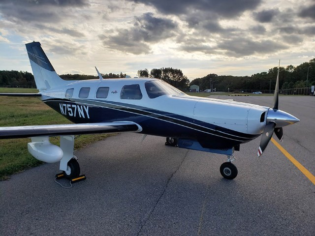
The occurrence aircraft was equipped with a Garmin G1000 avionics package that included 2 primary flight display units and 1 multi-function display unit. This system was enabled to provide the pilot with visual and aural alerts through a terrain awareness and warning system (TAWS), and was equipped with the Garmin SVT synthetic vision system.
The use of SVT can enhance the perspective when flying in conditions of reduced visibility. It provides a virtual flight reference to the G1000 display, giving the pilot a 3-dimensional topographic landscape map of the upcoming terrain that is linked with the G1000’s terrain database. The ground and water features are depicted on the screen so as to reflect their relative proximity to the aircraft, which can increase situational orientation with the surrounding environment.
All databasesFootnote 11 required for the TAWS and SVT to operate were found on the memory card that was installed; however, neither terrain nor SVT information were being displayed prior to impact with the terrain. It was not possible to determine conclusively why the terrain display and SVT were not active at the time of the occurrence.
The aircraft was not equipped with a flight data recorder nor a cockpit voice recorder, and neither were required by regulation.
There were no reported deficiencies on the aircraft.
Survival aspects
The aircraft was equipped with a 406 MHz ELT that activated on impact and provided the initial notification to the JRCC.
Both pilots were wearing their seatbelts and their shoulder harnesses. Both shoulder harness retraction mechanisms were partially detached from the airframe structure, which indicates that the deceleration forces at impact were significant.
The ferry pilot’s personal satellite tracking device allowed him to send and receive position reports and email messages via satellite network, which enabled him to communicate with a pre-determined contact and subsequently with the JRCC. He also used the hand-held VHF radio to communicate directly with the rescue aircraft, which was beneficial in planning and executing the rescue.
Controlled flight into terrain
Controlled flight into terrain (CFIT) “occurs when an airworthy aircraft under the control of the flight crew is flown unintentionally into terrain, obstacles, or water, usually with no prior awareness by the crew.”Footnote 12
This type of accident often occurs in low visibility, at night, or in poor weather. These conditions reduce the pilot's awareness of the surrounding area and make it difficult to determine visually the aircraft's proximity to terrain.
In this occurrence, the plan to initially fly VFR below the highest terrain elevation along the route introduced 2 hazards: flying over rising terrain in deteriorating weather conditions, and flying over snow-covered featureless terrain.
Accidents associated with continuing VFR flight into instrument meteorological conditions (IMC) where pilots lose visual reference with the ground are well documented and have a high fatality rate. According to data collected by the TSB between 2000 and 2014, these types of accidents resulted in 74 fatalities.
The hazards associated with flying in whiteout conditions are also well known. The Glossary for Pilots and Air Traffic Personnel defines a whiteout as:
An atmospheric optical phenomenon of snow-covered regions in which the observer appears to be engulfed in a uniformly white glow. Shadows, the horizon, and clouds are not discernible; depth perception and the sense of orientation are lost; and only very dark, nearby objects can be seen. Whiteout occurs over an unbroken snow cover and beneath a uniformly overcast sky when, with the aid of the snowblink effect, the light from the sky is about equal to that from the snow surface. Blowing snow may be an additional cause.Footnote 13
Flight in whiteout conditions can occur in clear air. The lack of cues and a poorly defined visual horizon can reduce the pilot’s ability to differentiate between the sky and terrain and to realize that the horizon is no longer visually discernible.
The risk of an accident is significant for an aircraft flown below the highest elevation along a route where the terrain is snow-covered and lacking features such as trees and rocks to provide definition.
VFR flight into IMC and flight in whiteout each present significant risk on their own. The combination of these 2 conditions will increase the risk of CFIT to an even higher level.
The ferry pilot knew the hill existed and had planned to fly around it or over the top if visual reference was lost. However, that plan was not executed and impact occurred without warning.
Safety messages
In this occurrence, the altitude that was planned and flown was lower than the highest elevation of terrain along a route where visual references to the ground were reduced. It is important for pilots to operate aircraft with adequate clearance from obstacles and terrain along a VFR route. In such situations, it is important that pilots maintain situational awareness in order to reduce the risks associated with flight into rising terrain by using all available means.
A personal satellite tracking device, a PLB, a handheld VHF radio, and a functioning aircraft ELT can assist rescuers to locate an accident site and increase the chance of survival.
This report concludes the Transportation Safety Board of Canada’s investigation into this occurrence. The Board authorized the release of this report on . It was officially released on .