Runway overrun
North Star Air Ltd.
Pilatus Aircraft Ltd. PC-12/45, C-GEOW
Kasabonika Airport (CYAQ), Ontario
The Transportation Safety Board of Canada (TSB) investigated this occurrence for the purpose of advancing transportation safety. It is not the function of the Board to assign fault or determine civil or criminal liability. This report is not created for use in the context of legal, disciplinary or other proceedings. See Ownership and use of content. Masculine pronouns and position titles may be used to signify all genders to comply with the Canadian Transportation Accident Investigation and Safety Board Act (S.C. 1989, c. 3).
History of the flight
On 21 November 2023, the Pilatus Aircraft Ltd. (Pilatus) PC-12/45 aircraft (registration C-GEOW, serial number 244) operated by North Star Air Ltd. (North Star Air) departed the Sioux Lookout Airport (CYXL), Ontario, at 1820All times are Central Standard Time (Coordinated Universal Time minus 6 hours). on an instrument flight rules flight to the Kasabonika Airport (CYAQ), Ontario, with 2 pilots and 6 passengers on board. The captain was the pilot flying and the first officer (FO) was the pilot monitoring.
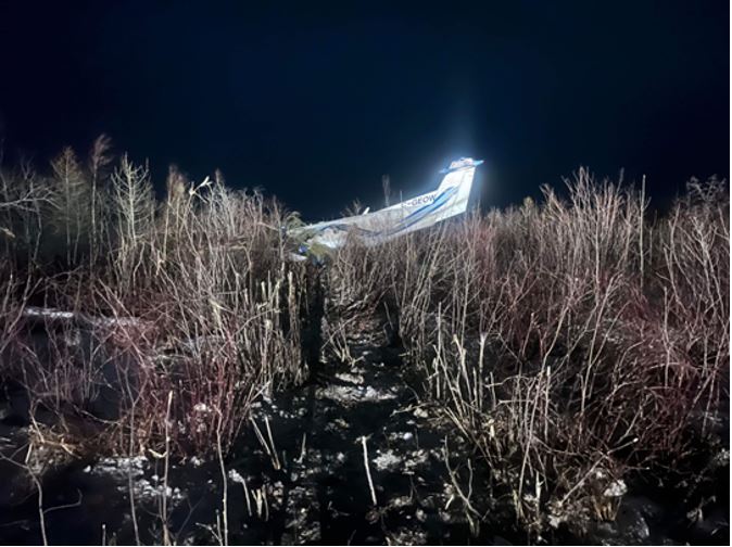
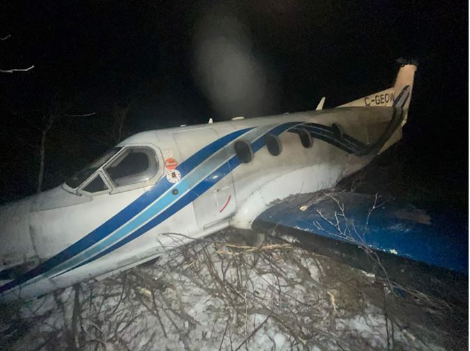
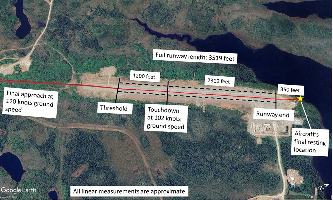
On approach to CYAQ, the pilots conducted an area navigation approach to Runway 03, using the autopilot coupled with a GPS (global positioning system). The captain then turned off the autopilot at 1000 feet above ground level (AGL) per the aircraft’s pilot operating handbook (POH) limitation.Pilatus Aircraft Ltd., PC12 Pilot’s Operating Handbook, Revision 26 (14 October 2022), Section 2: Limitations, p. 2-24. The approach continued at 120 knots ground speed with the flaps set to 15°. The aircraft touched down approximately 1200 feet beyond the threshold of Runway 03 at 102 knots ground speed. During the landing roll, the captain applied reverse thrust momentarily, which resulted in a slight yawing motion of the aircraft. The reverse thrust was returned to the idle position, and directional control was restored. The captain then fully applied the brakes; however, at 1938, the aircraft skidded and overshot the end of the runway. The aircraft came to rest approximately 350 feet beyond the runway surface (Figure 1). The aircraft cabin remained upright and intact (Figure 2). The passengers and crew were not injured and were able to egress though the main cabin door. The aircraft’s emergency locator transmitter activated.
Flight crew
The captain had 3133 total flight hours. Of these, around 2000 hours were on the Pilatus PC-12/45 aircraft, including about 420 hours as pilot-in-command. The FO had approximately 690 total flight hours, of which around 430 hours were as FO on the Pilatus PC-12/45 aircraft.
Both had valid medical certificates and held the appropriate licences and ratings for the flight in accordance with existing regulations.
According to information gathered during the investigation, there was no indication that the flight crew’s performance was affected by medical or physiological factors.
Aircraft information
The Pilatus PC-12/45 aircraft is a single-engine, turbine-powered, pressurized light airplane with seating for 2 flight crew and 9 passengers. The maximum gross take-off weight is 9921 pounds. The occurrence aircraft was equipped with a standard hydraulic braking system (non-anti-skid) and a Garmin GTN 625 navigation receiver/display. There were no recorded defects outstanding at the time of the occurrence, and there was no indication that a component or system malfunction played a role in this occurrence. The aircraft’s weight and centre of gravity were within the prescribed limits. Its weight upon landing at CYAQ was 9222 pounds. The maximum demonstrated crosswinds for landing listed in the POH were 25 knots with a flap setting of 15°, and 15 knots with a flap setting of 40°.Ibid., Section 9: Supplement 8, subsection 4.2: Airspeeds for normal operations. The POH states that these values are not a limitation.
Damage to aircraft
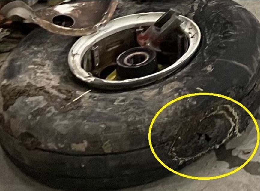
The landing gear collapsed, and the propeller, engine, and cowling were substantially damaged. The fuselage was buckled, and the wings, ailerons, and flaps sustained extensive damage. The main landing gear tires were blown, with damage indicative of heavy skidding (Figure 3).
Weather information
CYAQ does not have a weather reporting station. The nearest stations are at Big Trout Lake Airport (CYTL), Ontario, located 48 nautical miles (NM) to the northwest; Lansdowne House Airport (CYLH), Ontario, 84 NM to the southeast; and Pickle Lake Airport (CYPL), Ontario, located 138 NM to the south.
The aerodrome routine meteorological reports (METARs) issued at 1900 on the day of the occurrence indicated the conditions described in Table 1.
| Weather condition | CYTL | CYLH | CYPL |
|---|---|---|---|
| Winds | From 290° true (T) at 17 knots, gusting to 26 knots | From 280°T (variable between 230°T and 310°T) at 10 knots, gusting to 17 knots | From 310°T (variable between 260°T and 360°T) at 10 knots, gusting to 19 knots |
| Visibility | 6 statute miles (SM) in light snow | 9 SM | 9 SM in light snow |
| Sky | Overcast ceiling at 2200 feet | Clear | Overcast ceiling at 2400 feet |
| Temperature/Dew point | –7.8 °C/–10.6 °C | –7.3 °C/–10.8 °C | –7.2 °C/–11.1 °C |
| Altimeter setting | 29.86 inches of mercury (inHg) | 29.89 inHg | 29.93 inHg |
The Clouds and Weather Chart from the graphic area forecast, issued at 1127 and valid at 1800 for the route, indicated the following:
- Surface winds from the west at 20 knots, gusting to 35 knots
- Visibility greater than 6 SM
- Broken clouds between 3000 and 7000 feet above sea level (ASL)
- Isolated towering cumulus at 6000 feet ASL with 4 SM visibility in light snow showers
- Patchy ceilings at 1500 feet AGL
Runway information
CYAQ has a single runway, Runway 03/21, that is 3519 feet long and 100 feet wide. Both ends of the runway are serviced with area navigation instrument approaches with similar minimums. The surface is gravel. Runway 03 has a 1.08% downslope; conversely, Runway 21 has a 0.92% upslope.
There is a runway strip at the end of Runway 03 that is 60 m (197 feet) long, as required by standards in place at the time of runway certification. The runway strip is intended to reduce the risk of damage to aircraft running off the end of the runway.Transport Canada, TP 312, Aerodrome Standards and Recommended Practices, 4th Edition, Revision 2 (April 2005), Section 1.1. Definitions, p. 1-5. Neither end has a 150-m runway end safety area (RESA),A runway end safety area (RESA) is an “area symmetrical about the extended runway centreline intended to reduce the severity of damage to an aeroplane undershooting or overrunning the runway.” (Source: Transport Canada, TP 312, Aerodrome Standards and Recommended Practices: Land Aerodromes, 5th Edition [effective 15 January 2020], Section 1.1. Definitions, p. 26.) nor was one required by regulation.
The runway condition reported at 1704 by NOTAM was 100% compacted snow/gravel mix. A Canadian Runway Friction Index (CRFI)The Canadian Runway Friction Index means “the average of the friction measurements taken on runway surfaces on which freezing or frozen contaminants are present.” (Source: Transport Canada, Advisory Circular [AC] 300-019: Global Reporting Format [GRF] for Runway Surface Conditions, Issue 02 [21 February 2021], Section 2.3 Definitions and Abbreviations.) is not required by regulation for gravel runways and was not provided.Transport Canada, SOR/96-433, Canadian Aviation Regulations, section 302.416.
Standard operating procedures
North Star Air holds a valid air operator certificate for operations conducted under subparts 703 (air taxi), 704 (commuter) and 705 (airline) of the Canadian Aviation Regulations. The occurrence flight was operated with 2 pilots as an air taxi service, which required the operator to “establish and maintain standard operating procedures”Ibid., subsection 703.107(1). (SOPs).
North Star Air’s SOPs applicable to this occurrence are listed below:
- Tailwind: “No pilot shall takeoff or land with a tailwind component exceeding 10 kts [knots].”North Star Air Ltd., PC12 Standard Operating Procedures, Revision 5 (01 October 2022), Section 2.1.1: Tailwind Restrictions.
- Crosswind: “No First Officer shall takeoff or land with a crosswind component greater than 15 kts.”Ibid., Section 2.1.2: Crosswind Restrictions.
- Crosswind:
PIC [pilot-in-command] to use as stated in POH, flap positions and maximum demonstrated crosswind limit:
- 0° flap → 30 kts
- 15° flap → 25 kts
- 30° flap → 20 kts
- 40° flap → 15 ktsIbid., Section 2.1.6: Landing Maximum Crosswind Units.
- Landing:
When landing in gusty wind conditions, increase ref speed by adding ½ of gust to the published ref speed to a maximum of 15 KIAS [knots indicated airspeed]. Touchdown must take place in the first 1000 feet of the runway. […]
To maximize the life of the engine, reverse is to be used as little as possible, minimal braking and full length. Full use of brakes and reverse is obviously acceptable to prevent overrun.Ibid., Section 2.12: Landing.
- Gravel runway landing: “The use of BETA and Reverse should be kept to a minimum. If possible, reverse not used at all.”Ibid., Section 2.12.1: Landing – Gravel Operations.
Landing of the occurrence aircraft
The weather conditions present and forecast during the occurrence showed winds moving westerly to become favourable for takeoffs and landings on Runway 21. The final approach was 120 knots ground speed during the last 500 feet of the approach. The aircraft crossed the threshold at 110 knots ground speed and touched down approximately 1200 feet beyond the threshold at 102 knots ground speed (Figure 4).
Landing performance calculations
The manufacturer’s landing performance specifications in the POH are provided for dry and paved runway conditions only. The Pilatus PC-12/45 aircraft’s normal approach speed for landing with 15° flaps is 98 KIAS.Pilatus Aircraft Ltd., PC12 Pilot’s Operating Handbook, Revision 26 (14 October 2022), Section 9: Supplement 8, subsection 4.2: Airspeeds for normal operations. However, the aircraft had an approach speed of 120 knots ground speed. Because the final approach ground speed exceeded the Pilatus PC-12’s landing performance charts found in the POH,Ibid., subsection 5: Performance, figures 5-63, 5-65, 5-67, and 5-69. it was not possible to calculate the distance the aircraft would have needed given these conditions. In addition, the charts in the POH do not provide compensation for gravel runways or for runway contaminants such as ice, rain, or snow.
Based on calculations made using the aircraft’s landing performance charts, when landing with a 10-knot tailwind (the maximum charted tailwind) and without the use of reverse thrust, the aircraft would need 3458 feet of available runway (Table 2).
Flap configuration | Final approach speed | Reverse thrust | Landing roll | Total landing distance, from when the aircraft is 50 feet high |
|---|---|---|---|---|
15° | 98 KIAS | Yes | 1493 ft | 2855 ft |
15° | 98 KIAS | No | 1991 ft | 3458 ft |
40° | 80 KIAS | Yes | 1140 ft | 2180 ft |
40° | 80 KIAS | No | 1520 ft | 2640 ft |
While not required for certification, Pilatus has published 2 aircraft performance information leaflets related to operations on unpaved or contaminated runways.Pilatus Aircraft Ltd., Information Leaflet No. 02195: Performance Charts for PC-12, PC-12/45 and PC-12/47 Operations from Prepared Unpaved Surfaces, Revision 1 (22 December 2006).,Pilatus Aircraft Ltd., Information Leaflet No. 02400: Performance Information for PC-12, PC-12/45/47 and PC-12/47E Contaminated Runway Data, Revision 04 (19 April 2023). Neither of these publications have guidance for operation on runways reporting 100% compacted snow/gravel mix.
The Transport Canada Aeronautical Information ManualTransport Canada, TP 14371, Transport Canada Aeronautical Information Manual (TC AIM), AIR – Airmanship (05 October 2023), Section 1.6.7, Table 1.3, Table 1.4, and Figure 1.1. (TC AIM) includes compensating tables to help pilots determine landing distances as well as guidance for crosswind limits to maintain directional control on contaminated runway surfaces for crosswind landings. The TC AIM does not, however, provide guidance in determining landing distances on gravel runways.
Takeoffs and landings with a tailwind component have an increased risk of runway overruns. The use of reverse thrustJohn Hayes, “Reverse thrust: stopping with style”, in AOPA Pilot (01 March 2017), at aopa.org/news-and-media/all-news/2017/march/pilot/turbine-reverse-thrust (last accessed on 18 October 2024). and anti-skid brakingSKYbrary, “Brakes”, at skybrary.aero/articles/brakes#:~:text=Anti%2Dskid%20System&text=If%20the%20speed%20of%20any,prevent%20the%20wheel%20from%20skidding (last accessed on 18 October 2024). has been proven to be effective in reducing runway overruns.
TSB Watchlist
The TSB Watchlist identifies the key safety issues that need to be addressed to make Canada’s transportation system even safer.
Runway overruns are a TSB Watchlist 2022 issue and have been a Watchlist issue since 2010. The TSB has investigated many runway overruns that occurred in the past few years.Recent TSB investigations of runway overruns include occurrences A23C0081, A23O0046, A22Q0025, and A22O0161 (ongoing investigations) and A21O0127, A21Q0087, and A21O0066 (completed investigations with reports published).
Runway 03 at CYAQ has a 60 m runway strip, but it does not have a 150 m RESA, nor is one required by existing regulations. As this occurrence demonstrates, when a runway overrun occurs during landing, it is important that the aircraft have an adequate safety area beyond the end of the runway strip to reduce adverse consequences. Despite the actions taken to date, the number of runway overruns in Canada has remained constant since 2005 and demands a concerted effort to be reduced.Transportation Safety Board of Canada, “TSB Watchlist 2022: Runway overruns”, at www.tsb.gc.ca/eng/surveillance-watchlist/aviation/2022/air-02.html (last accessed on 18 October 2024).
TSB laboratory reports
The TSB completed the following laboratory report in support of this investigation:
- LP162/2023 – NVM Data Recovery - Various
Safety action taken
After the occurrence, North Star Air revised its SOPs to include cross-checking of ground speed to indicated airspeed on final approaches.
Safety messages
Pilots are reminded that when runway surfaces are contaminated, difficulty may be experienced maintaining directional control during crosswind takeoffs and landings.
Pilots need to ensure that their ground speed on approach correlates to published approach speeds and consider the runway conditions so that a safe landing can be accomplished, especially when aircraft performance calculations reveal that the total landing distance required is close to the runway length available.
When winds are not reported or available to flight crews, visual confirmation of wind direction and speed with the aerodrome windsock is always preferred; however, GPS, when available and correctly utilized, can help pilots determine their aircraft’s ground speed, which they can then compare to the indicated airspeed to determine the presence of a tailwind during a final approach to landing.
This report concludes the Transportation Safety Board of Canada’s investigation into this occurrence. The Board authorized the release of this report on 30 October 2024. It was officially released on 05 November 2024.


