Controlled flight into terrain
Summit Helicopters Ltd.
Bell Helicopters Textron Inc. 407 (helicopter), C-GTHU
Terrace, British Columbia, 15 NM NNW
The Transportation Safety Board of Canada (TSB) investigated this occurrence for the purpose of advancing transportation safety. It is not the function of the Board to assign fault or determine civil or criminal liability. This report is not created for use in the context of legal, disciplinary or other proceedings. See Ownership and use of content. Masculine pronouns and position titles may be used to signify all genders to comply with the Canadian Transportation Accident Investigation and Safety Board Act (S.C. 1989, c. 3).
Summary
On 04 January 2023, the Summit Helicopters Ltd. Bell Helicopters Textron Inc. model 407 helicopter (registration C-GTHU, serial number 53333) was carrying tourists from Terrace Airport (CYXT), British Columbia, to the Northern Escape Mountain Lodge, located approximately 15 nautical miles to the north-northwest. En route, the pilot was informed by lodge personnel that low-level fog had moved into the area surrounding the lodge. The pilot decided to descend and follow the Kitsumkalum River to maintain a visual reference to the ground in an effort to proceed.
As the flight proceeded over Treston Lake and visibility continued to decrease in fog, the pilot flew at less than 100 feet above the lake and slower than 30 knots ground speed. The pilot momentarily lost outside visual reference, and the helicopter contacted the frozen surface of the lake at 1136 Pacific Standard Time. During the contact, the landing skids were significantly damaged but the pilot managed to keep the helicopter flying. The pilot elected to climb above the fog and proceeded to the west toward the lodge. Seeing a break in the fog, the pilot descended and landed at the lodge, where the passengers disembarked.
There were no injuries, and the emergency locator transmitter did not activate.
1.0 Factual information
1.1 History of the flight
1.1.1 Background
On 04 January 2023, Summit Helicopters Ltd. (Summit) was scheduled to transport 12 passengers from Terrace Airport (CYXT), British Columbia (BC), on an approximately 15-minute flight to the Northern Escape Mountain Lodge (the lodge) located approximately 15 nautical miles (NM) north-northwest of CYXT on the western shore of Treston Lake, BC. Summit had planned for 2 helicopters to be operated: one of its Bell Helicopters Textron Inc. (Bell) 412 helicopters would carry 8 passengers, and a helicopter sub-chartered from another operator would transport the remaining passengers. However, due to unplanned circumstances, the charter operator was unable to perform the flight, and Summit’s base manager elected to perform the flight himself in a 2nd company helicopter, a Bell 407.
1.1.2 Occurrence flight
After arriving at the Summit hangar facility at CYXT that morning, the base manager (the occurrence pilot) obtained the weather observations and forecasts (from sources that included NAV CANADA and other publicly available weather websites) and co-ordinated the operations for the day. He had also observed the weather during his commute to the airport. He noted, based on his experience flying out of the airport and on his knowledge of local weather patterns, that if the weather conditions at CYXT were acceptable for dispatch, the conditions in the surrounding area would also be acceptable for flight. Before the passengers arrived, the occurrence pilot and the Bell 412 pilot conducted a coordination briefing for the flight from CYXT to the lodge. They planned on flying a loose formation in trail with a couple of miles of separation between the 2 helicopters. Each pilot completed his own risk assessment using a software program provided by Summit and obtained weather information.
The 12 passengers arrived at the Summit hangar facility at approximately 1100.Footnote 1 The occurrence pilot, along with the pilot of the 2nd helicopter, conducted a passenger safety briefing for the passengers and then proceeded to load the baggage onto the Bell 412 and divide the passengers into 2 groups. One group of 8 passengers was to be transported to the lodge in the Bell 412, and the other group of 4 was to be in the occurrence helicopter. Of these 4 passengers, 1 was seated in the front left seat (i.e., in the passenger seat). The occurrence helicopter departed for the lodge at 1121, followed shortly afterward by the Bell 412. The occurrence flight proceeded north-northwest of CYXT at an altitude that varied between 900 and 1500 feet above ground level (AGL) and at a ground speed of approximately 109 knots.
En route to the lodge, the occurrence pilot made radio contact with lodge personnel and was informed that low-level fog had moved into the area surrounding the lodge and vertical visibility was variable. Approximately 8 minutes (14 NM) into the flight, he decided that he would not be able to fly directly to the lodge because the fog was obscuring the lodge and the valley.
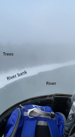
The occurrence pilot then made the decision to descend into the fog and fly along the Kitsumkalum River with the intention of maintaining visual reference to the ground following the contrast of the river (Figure 1).
This was the route he had successfully taken on his previous flights to the lodge in conditions of reduced visibility. He communicated his intentions to the Bell 412 pilot, who elected to fly over the fog, directly to the lodge, and assess the landing conditions there. The pilot of the Bell 412 did not communicate this plan to the occurrence pilot. The visibility over the river was estimated to be approximately between ¾ and 1 statute mile (SM). The occurrence pilot then flew north following the contrast of the river at a height that progressively decreased from approximately 100 feet to 30 feet above the river, and at a ground speed that varied from 46 knots to 16 knots.
The river was not frozen over; it had dark flowing water and thus provided a visual contrast with the surrounding snow-covered ground for the pilot to maintain visual reference. However, except for a current of flowing water through the lake, the majority of Treston Lake was frozen and covered in snow. Thirteen minutes into the flight and ½ NM east of the lodge, the occurrence helicopter turned away from the river and started flying westward along the southern shore of Treston Lake. At this point, the pilot still believed he was following the river. Visibility over the lake continued to decrease. After flying approximately ¼ NM west following the southern shore of the lake, the pilot realized his actual position and turned to the north and crossed the lake toward the north shore to follow that reference to arrive at the destination. While flying across the lake, the pilot started to experience significantly reduced visibility due to the fog. The helicopter’s ground speed at this time varied between 17 knots and 26 knots, and its height varied between 20 feet and 100 feet above the lake surface. The helicopter’s track then changed more than 90° toward the west (Figure 2).
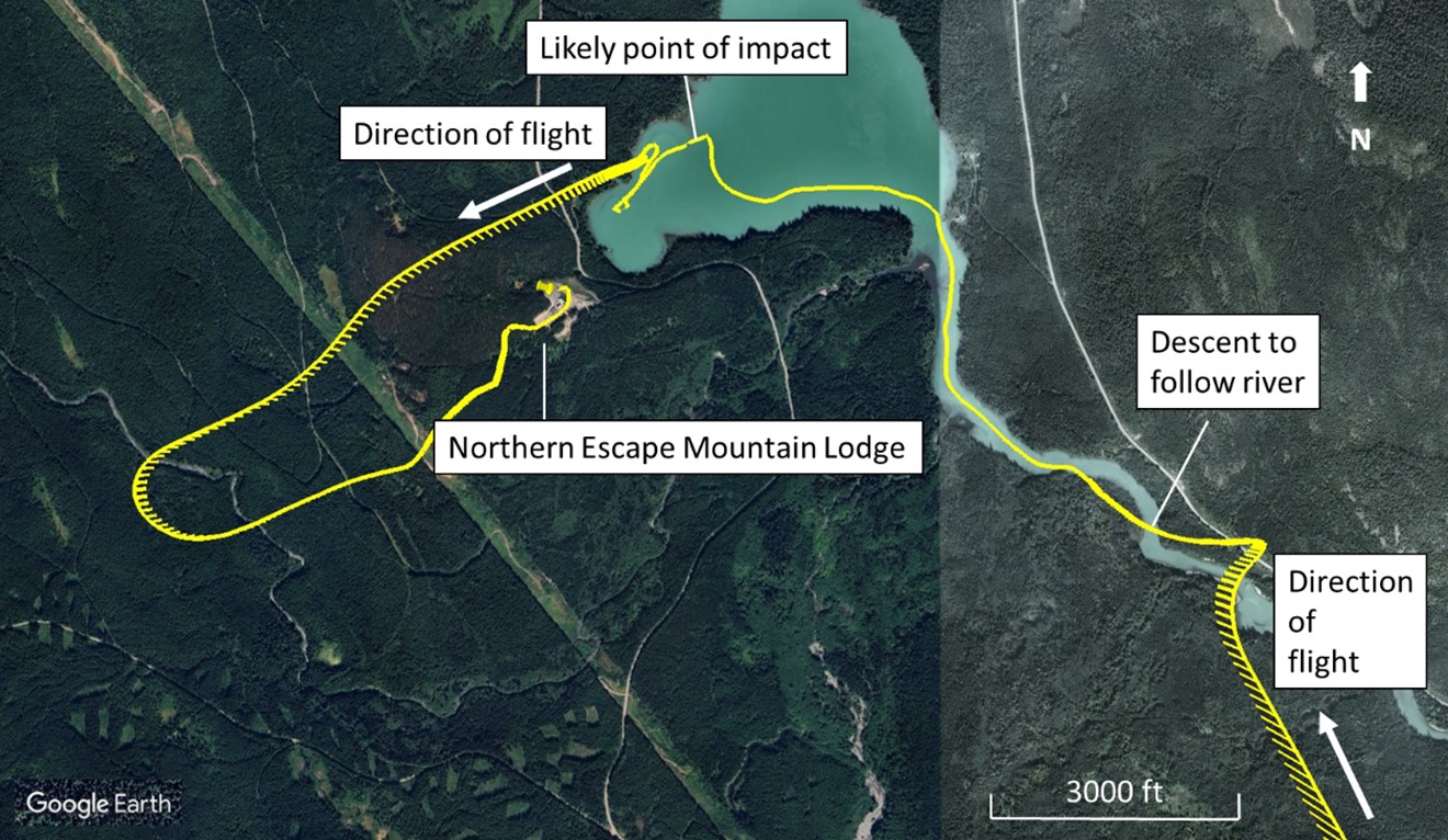
As the change in track was being completed, the altitude of the helicopter decreased inadvertently while the pilot temporarily lost visual reference with the frozen surface of the lake, and contact with the surface was made (Figure 3) at a ground speed of about 4 knots. The pilot felt the contact with the surface but managed to keep the helicopter flying. The pilot then continued flying to the west using the north shore of the lake for reference. Approximately ⅕ NM west of the point of surface contact, the helicopter entered an unintentional descending turn to the left through about 180°. Because of the helicopter’s low ground speed, its track change was not displayed on the ForeFlight application that the pilot was using to assist him in navigating.Footnote 2 This led the pilot to fly back toward the east briefly until the application began to indicate the correct direction of flight.
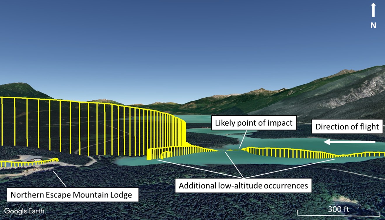
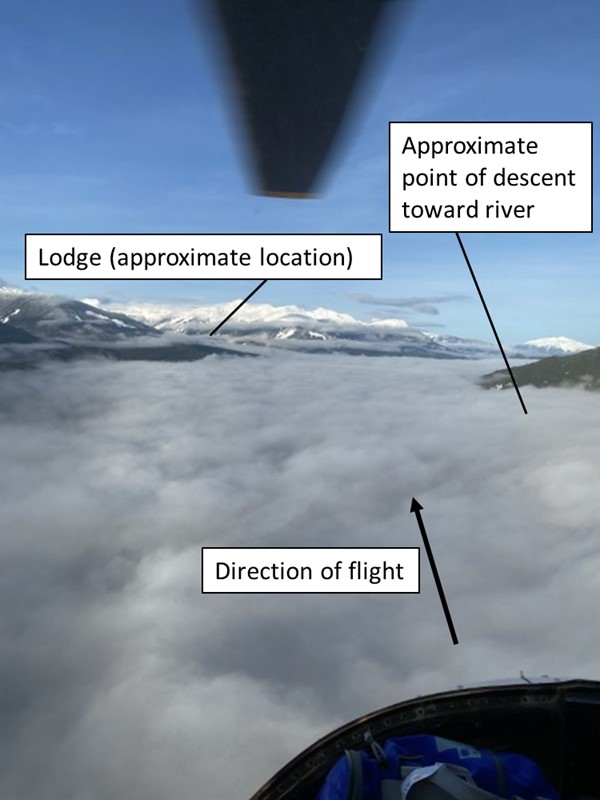
At this point, the pilot performed a left turn to head west toward the lodge and made the decision to climb up through the fog. Once on top of the fog, the pilot proceeded to fly on a westerly heading 9/10 NM west of the lodge. Owing to the environmental conditions the pilot encountered in the vicinity of the lodge, an alternate plan was considered in landing at a landing pad along a power line that was approximately ½ SM west of the lodge.
While west of the lodge, the occurrence pilot was able to make radio contact with the Bell 412 pilot, who reported that he had landed at the lodge. Not wanting to land the helicopter far away from the lodge, the occurrence pilot performed a 180° left turn to head back toward it. While the helicopter was approaching the lodge, although the visibility was less than ½ SM, the pilot was able to regain a ground reference through a break in the fog and descended to land on a landing pad at the destination, at approximately 1141. The pilot shut the helicopter down, and all passengers disembarked.
There were no injuries. The emergency locator transmitter did not activate.
1.2 Injuries to persons
One pilot and 4 passengers were on board. There were no injuries.
1.3 Damage to aircraft
The high-skid landing gear sustained significant damage.
1.4 Other damage
There was no other damage.
1.5 Personnel information
The pilot held the appropriate licence and rating for the flight in accordance with existing regulations.
| Pilot | |
|---|---|
| Pilot licence | Airline transport pilot licence - helicopter |
| Medical expiry date | 01 September 2023 |
| Total flying hours | 5515.3 |
| Flight hours on type | 344.5 |
| Flight hours in the 7 days before the occurrence | 0.5 |
| Flight hours in the 30 days before the occurrence | 8.9 |
| Flight hours in the 90 days before the occurrence | 22.6 |
| Hours on duty before the occurrence | 4 |
| Hours off duty before the work period | 13 |
The pilot held an airline transport pilot licence – helicopter with a Group 4 instrument rating. He was rated on multiple helicopter types including the Robinson R22 and R44; Bell models 47, 206, 407, and 412; Sikorsky S-76; and Airbus Helicopters EC 120 and EC 130. In addition, the pilot held a single-engine landplane commercial pilot licence endorsed with a Group 3 instrument rating. He held a valid Category 1 medical certificate.
While employed by Summit, the pilot flew the Bell 407 and, as required, the Bell 412. As a pilot, he reported to the Chief Pilot, VFR (visual flight rules). The pilot was current on the Bell 407 and had successfully completed his last pilot proficiency check and annual VFR flight training in the Bell 407 on 11 February 2022. Both his pilot proficiency check and his VFR training were valid until 01 March 2023. The VFR training flight was 2.5 hours long and included a portion on mountain flying and a minimum of 0.3 flight hours spent on low-visibility flight operations, which consisted of low-speed manoeuvring and a 180° course reversal at low speed. The training met the applicable regulatory standards.Footnote 3 In addition, the pilot received low visibility training in a Bell 412 Level D simulator in October 2022.
In February 2022, the occurrence pilot also completed the company’s annual recurrent crew resource management (CRM) training course, which included threat and error management (TEM), pressures and stress, communication, and fatigue.
Based on a review of the pilot’s work and rest schedule, there was no indication that the pilot’s performance was degraded by fatigue.
1.5.1 Additional duties
In addition to his flight duties with Summit, the occurrence pilot’s primary responsibility was as the base manager for the Terrace company facility. As the base manager, he reported to Summit’s general manager, which included participating in regular meetings and communications to discuss and resolve issues as they arose. In this role, the pilot was responsible for:
- ensuring the upkeep and maintenance of the Terrace hangar facility;
- interacting with current and potential clients;
- requesting/scheduling aircraft and flight crew resources;
- taking care of transportation and accommodation logistics for flight crews;
- managing the Terrace-based vehicle fleet; and
- taking care of miscellaneous day-to-day activities to ensure a smooth-running operation.
At the time of the occurrence, there was no formal job description for the base manager in any company documentation.
1.6 Aircraft information
The Bell 407 is a light utility helicopter with a single turbine engine and a single main rotor. It has the capacity to carry 1 pilot and 6 passengers. The single-main-rotor system consists of 4 blades of composite construction, and the tail rotor is of a 2-bladed arrangement. The occurrence helicopter was also equipped with the optional high-skid landing gear.
| Manufacturer | Bell Helicopters Textron Inc. |
|---|---|
| Type, model and registration | Helicopter, BH407, C-GTHU |
| Year of manufacture | 1999 |
| Serial number | 53333 |
| Certificate of airworthiness/flight permit issue date | 24 May 2012 |
| Total airframe time | 7080.6 hours |
| Engine type (number of engines) | Rolls-Royce Corporation (Allison) 250C-47B (1) |
| Rotor type (number of blades) | Semi-rigid (4) |
| Maximum allowable take-off weight | 2381.4 kg |
| Recommended fuel type(s) | Jet A, Jet A-1, Jet B |
| Fuel type used | Jet A |
The helicopter was being maintained in accordance with a maintenance schedule approved by Transport Canada (TC). Technical records indicate that the last progressive inspection was performed on 02 December 2022. The helicopter had flown approximately 25.9 hours since the inspection had been completed, with no defects recorded in the aircraft’s journey logbook. The most recent maintenance event was an emergency locator transmitter self-test that was completed the day before the occurrence.
At the time of the occurrence, the helicopter weighed 4750 pounds and was within the prescribed weight and centre of gravity limits.
There was no indication that an aircraft system or component malfunction contributed to this occurrence.
1.6.1 Flight instruments
The helicopter was certified and equipped for daytime VFR flight in accordance with section 605.14 of the Canadian Aviation Regulations (CARs).Footnote 4 Basic flight instrumentation included an airspeed indicator, an attitude indicator, a barometric altimeter, a vertical speed indicator, and a ball-in-tube slip and skid indicator.
The helicopter was not equipped with any type of autopilot or stability augmentation system, nor was it required to be by regulation for VFR flight operations.
1.7 Meteorological information
The nearest airport to the accident site was the departure airport, CYXT, located approximately 15 NM to the south-southeast. The aerodrome routine meteorological report (METAR) for CYXT issued on 04 January at 1100 and valid at the time of the departure reported the following:
- Winds 200° true at 2 knots (2.3 mph)
- Visibility 20 SM in shallow fog
- Few clouds at 500 feet AGL and 5000 feet AGL, and a broken ceiling at 23 000 feet AGL
- Temperature −4 °C, dew point −5 °C
- Altimeter setting 29.90 inches of mercury (inHg)
This weather was consistent with the conditions the pilot observed while driving to the airport.
The terminal area forecast (TAF) for CYXT issued at 1040 and valid from 1100 to 2300 forecast the following weather conditions between 1100 and 1900:
- Scattered cloud at 2000 feet AGL, a broken ceiling at 6000 feet AGL, and an overcast layer at 12 000 feet AGL
- Temporarily between 1100 and 1900, a scattered cloud layer at 6000 feet AGL, and a broken ceiling at 21 000 feet AGL
- Between 1100 and 1300, a 30% probability of visibility dropping to 1 SM in mist
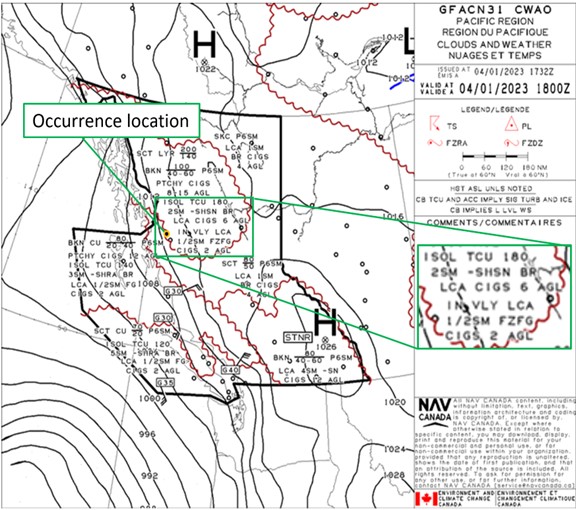
The graphic area forecast (GFA) for the Pacific Region issued at 0932 and valid at 1000 (Appendix A) indicated that for the greater Terrace, BC, area, the following conditions could be experienced:
- Patchy ceilings between 800 feet and 1500 feet AGL
- Isolated towering cumulus clouds to 18 000 feet ASL, giving a visibility of 2 SM in light snow showers and mist
- Local ceilings of 600 feet AGL
- In valleys, local visibility of ½ SM in freezing fog with ceilings of 200 feet AGL
The pilot had accessed these NAV CANADA weather products before the flight.
1.7.1 Whiteout
The Transport Canada Aeronautical Information Manual (TC AIM) describes the term whiteout as follows in the section on flight operations in winter:
Whiteout (also called milky weather) is defined in the Glossary of Meteorology (published by the American Meteorological Society) as:
“An atmospheric optical phenomenon of the polar regions in which the observer appears to be engulfed in a uniformly white glow. Neither shadows, horizon, nor clouds are discernible; sense of depth and orientation is lost; only very dark, nearby objects can be seen. Whiteout occurs over an unbroken snow cover and beneath a uniformly overcast sky, when with the aid of the snowblink effect, the light from the sky is about equal to that from the snow surface. Blowing snow may be an additional cause.”
Light carries depth perception messages to the brain in the form of colour, glare, shadows, and so on. These elements have one thing in common, namely, they are all modified by the direction of the light and changes in light intensity. For example, when shadows occur on one side of objects, we subconsciously become aware that the light is coming from the other. Thus, nature provides many visual clues to assist us in discerning objects and judging distances. What happens if these clues are removed? Let’s suppose that these objects on the ground and the ground itself are all white. Add to that, a diffused light source through an overcast layer which is reflected back in all directions by the white surface so that shadows disappear. The terrain is now virtually devoid of visual clues and the eye no longer discerns the surface or terrain features.
[…]
Consequently, whenever a pilot encounters the whiteout conditions described above, or even a suspicion of them, the pilot should immediately climb if at low level, or level off and turn towards an area where sharp terrain features exist. The flight should not proceed unless the pilot is prepared and competent to traverse the whiteout area on instruments.
In addition, the following phenomena are known to cause whiteout and should be avoided if at all possible:
- water-fog whiteout resulting from thin clouds of super-cooled water droplets in contact with the cold snow surface. Depending on the size and distribution of the water droplets, visibility may be minimal or nil in such conditions.
- blowing snow whiteout resulting from fine snow being plucked from the surface by winds of 20 kt [knots] or more. Sunlight is reflected and diffused resulting in a nil visibility whiteout condition.
- precipitation whiteout resulting from small wind-driven snow crystals falling from low clouds above which the sun is shining. Light reflection complicated by spectral reflection from the snow flakes and obscuration of land marks by falling snow can reduce visibility and depth perception to nil in such conditions.
If at all possible, pilots should avoid such conditions unless they have the suitable instruments in the aircraft and are sufficiently experienced to use a low-speed and minima rate of descent technique to land the aircraft safely.Footnote 5
1.8 Aids to navigation
1.8.1 Electronic flight bag
In general, the main navigation tool used by pilots conducting VFR flights is the VFR navigation chart (VNC). It is available in paper format or digitally (e.g., with the ForeFlight application, as in this occurrence) and includes a topographical representation of the surface, with the terrain elevation indicated. However, the elevation is not indicated for all lakes. The elevation of Treston Lake, which is not provided on the VNC, is approximately 475 feet.
The terrain elevation indicated on VNCs is used mainly for pre-flight planning. Helicopter pilots flying at altitudes of 500 AGL or less estimate and maintain their altitude visually by following the terrain, rather than by maintaining a specific altitude indicated on a conventional altimeter.
During the occurrence flight, the pilot was using an iPad, located above the instrument panel, with the ForeFlight application for navigation information and a dedicated GPS receiver. The application provides GPS-derived speed, altitude, track, and location information and displays it to the pilot on a map. These data are also recorded digitally in a file known as a flight track log. The investigation was able to retrieve the flight track log for the occurrence flight (figures 2 and 3).
1.9 Communications
Not applicable.
1.10 Aerodrome information
Not applicable.
1.11 Flight recorders
The aircraft was not equipped with a flight data recorder or a cockpit voice recorder, nor was either required by regulation.
1.12 Wreckage and impact information
The helicopter impacted the snow-covered frozen surface of Treston Lake, close to the north shore. Both landing skids had been splayed out by the force of the impact. The TSB did not deploy to the occurrence site.
1.13 Medical and pathological information
According to the information gathered during the investigation, there was no indication that the pilot’s performance was degraded by medical factors.
1.14 Fire
Not applicable.
1.15 Survival aspects
Not applicable.
1.16 Tests and research
Not applicable.
1.17 Summit Helicopters Ltd.
Summit is a subdivision of the parent company Ledcor Group. It holds both an air operator certificate and an approved maintenance organization certificate from TC. Its main base of operation is located in Kamloops, BC, with several sub-bases located in Yellowknife, Northwest Territories; Prince George, BC; and Terrace, BC.
Summit is approved to conduct both aerial work (under CARs Subpart 702) and air-taxi operations (under CARs Subpart 703) in day VFR and day and night instrument flight rules (IFR) conditions. Its fleet consists of the Bell 206 series, Bell 407 series, and Bell 412 series of helicopters. Using its fleet of helicopters, the company offers support to such industries as oil and gas, tourism, and mining and exploration, as well as to provincial forestry departments and air ambulance operations.
1.17.1 Company operations manual
Summit has a company operations manual (COM), which, among other subjects, dictates how the flight department conducts flight operations. In its COM, Summit states that the Bell 407 is operated only in day VFR conditions.
1.17.1.1 Weather minima
Section 4.1 of the COM describes the weather minima in which the company conducts flight operations. Subsection 4.1.1 specifically details the VFR weather limits for pilots and states that the helicopter is to be operated with visual reference to the surface.
The COM states that in uncontrolled airspace,
(a) Flight visibility is not less than one mile, and
- At or above 1,000 feet AGL –
- The distance of the aircraft is not less than 500 feet vertically and 2,000 feet horizontally [from cloud]
- At less than 1,000 feet AGL
- The helicopter is operated clear of cloud.Footnote 6
Section 4.1.2 goes on to describe VFR flight in reduced visibility. In accordance with CARs sections 702.17(2)Footnote 7 and 703.28(2)(a)Footnote 8 and Commercial Air Service Standards section 723.28, Summit had received special authorization from TC to conduct operations in reduced visibility provided that certain conditions were met. This special authorization allowed the company to conduct day VFR flight operations in uncontrolled airspace with a visibility of ½ SM or greater at altitudes below 1000 feet AGL. To conduct flight operations in conditions of reduced visibility, the following criteria, listed in the COM, must be met:
- Pilots have achieved at least 500 hours of pilot-in-command experience in helicopters;
Helicopters shall be operated at a reduced air speed that will provide the pilot-in-command adequate opportunity to see and avoid all obstacles;
The minimum safe airspeed shall be in accordance with the Height-Velocity diagram in the approved RFM [rotorcraft flight manual] for the applicable type.
- Pilots shall have received initial and annual recurrent flight training for operations in reduced visibility as detailed in Section 6.21 of this Company Operations Manual.Footnote 9
Section 4.2 also states that VFR over-the-topFootnote 10 flight operations shall not be conducted.Footnote 11
1.17.1.2 Flight in hazardous conditions
Section 4.10 of the COM describes hazardous conditions that could arise during a flight and stipulates the mitigating actions that should be taken if such conditions are unintentionally encountered. It defines whiteout conditions as “[o]vercast (flat light), poor depth definition, no perception of aircraft movement.”Footnote 12
If, during the course of the helicopter operation, a pilot unexpectedly comes across these conditions, the pilot is to “[u]se available references, reverse course if possible, look for a feature that stands out from a surrounding terrain (tree, rocks etc.) [and] land as soon as possible.”Footnote 13
1.17.1.3 Risk assessment
At the time of the occurrence, Summit had in place a software program for flight crews to use in evaluating the risks associated with each flight. Company policy required risk assessments to be completed for both IFR and VFR flights. However, the software would allow the pilot to plan a VFR flight without completing the risk assessment. Before a flight, the pilot logs in to the company’s computer system and completes the risk assessment form by checking various boxes. Each risk item is assigned a predetermined value and, at the end of the assessment, the software program adds up the value of all checked items. A medium risk is triggered when the total value is greater than 30; a maximum value of 70 is permitted. If the value is greater than 30, the appropriate chief pilot is notified via an email and a text message. The chief pilot then reviews the risks with the pilot and they formulate a plan to reduce the risks as much as possible. This plan could include a delay to the flight or the cancellation of the flight if the risks are deemed too great. At this point, after the plan has been completed and the risks have been discussed, the pilot can proceed with filing the flight in the flight-tracking system.
In the case of the occurrence flight, the pilot had completed a risk assessment using the computer-based tool. The only risk identified was associated with winter operations. As a result, the risk assessment matrix generated a risk value of 5 and assessed the risk as acceptable.
1.17.2 Pressures influencing air-taxi operations
The air-taxi sector of aviation in Canada operates in highly competitive conditions.Footnote 14 As previously identified by the TSB, there exists a scarcity of pilots in Canada, which has had, and continues to have, an impact on air-taxi operators.Footnote 15 The need for air-taxi services continues, and companies, including Summit, strive to meet the demands of their clients impacted by tight financial constraints and other commercial pressures. Air-taxi operations are also diverse, involving flights such as medical evacuation and the transport of passengers for ski expeditions and workers for logging camps. These operations often take place in remote areas with dynamic weather, limited weather reporting, and rugged geography that consists of lakes, rivers, mountains, forests, and coasts.
This environment creates pressures that can impact operations, some of which are placed directly on a pilot, including:
- constantly changing weather and visibility, which can influence self-dispatch and navigation decision making;
- the direct interaction between pilots and clients, which can intensify the pressure to satisfy clients; and
- the highly competitive nature of the sector, which can increase the pressure on pilots to obtain and maintain client satisfaction and ensure the availability of aircraft and service in the right locations.Footnote 16
Summit is knowledgeable about these conditions and pressures, and the company trains and directs its pilots to manage their associated hazards. In the occurrence, a number of mitigation strategies were used:
- Before the flight, the occurrence pilot completed the company operational risk assessment.
- A pre-flight briefing was conducted, and the 2-ship coordination of the helicopters was planned.
- Weather was checked and a route was planned direct to the lodge.
- Communication between helicopters was initiated when the fog and mist were encountered en route.
- A base manager, who also flies when needed, had been installed to manage helicopter operations from the company’s Terrace base, which entailed managing client requests and expectations and overall logistics.
- The company had a voluntary safety management system (SMS) and required CRM training for all personnel involved in flight operations.
1.17.3 Pilot training program
1.17.3.1 Flight training
When operating under Subpart 703 of the CARs, crew members licensed for single-engine day VFR flights are required to hold a valid pilot proficiency check for the type of aircraft being operated.
At Summit, initial training for single-engine air-taxi operations under day VFR requires approximately 8 hours of ground training and a minimum of 1 hour of aircraft flight training. Recurrent training requires approximately 4 hours of ground training and a minimum of 1 hour of flight training.Footnote 17
The training and testing administered for a pilot proficiency check include normal and abnormal flight situations, and the pilot proficiency check can be issued to a pilot following the minimum 1-hour recurrent training flight. Both the initial and the recurrent pilot training for VFR flight operations at Summit do not include any training on instrument flight proficiency, IFR procedures, or escape manoeuvres in the event of a loss of visual reference, nor is any of this type of training required under the regulations.
1.17.3.2 Reduced visibility training
Pilot training is intended to enhance the knowledge and skills needed to effectively manage various flight-related risks. Section 6.21 of the COM details the ground training that pilots are required to have before conducting flights in uncontrolled airspace in conditions of reduced visibility down to ½ SM. It describes the hazard of whiteout, which it lists as one of the factors to be addressed during training, and provides the following warning to pilots:
The bottom line on this is: do not get into a white-out if you can help it. […] Occasions occur during flight where it is difficult to see that snow is falling from cloud ahead. You can unexpectedly enter snow and get into serious difficulty because of loss of visual reference. If the area ahead looks doubtful, turn around. Do not fly passed [sic] your present reference point without the next reference point in sight.Footnote 18
The manual goes on to reiterate the criteria it states in section 4.1.2 for low-visibility flight operations, this time describing the reduction of airspeed as an option available to pilots to mitigate risk should they encounter whiteout conditions during flight:
(i) Aircraft Minimum Speed:
On encountering low visibility operations, the helicopter shall be flown at a reduced [emphasis in original] airspeed that will provide the pilot adequate opportunity to see and avoid obstacles.
The minimum safe airspeed shall be in accordance with the Height/Velocity diagram in the approved RFM for the applicable type.Footnote 19
The COM does not specify a particular airspeed for each helicopter type operated by Summit, but instead directs the pilot to consult the applicable RFM.
The training also includes a practical flight-training segment with an allotted flight time of 15 minutes. It covers low altitude and low-speed manoeuvring, including a low-speed course reversal (180° turn).
1.17.3.3 Training on controlled flight into terrain
Air-taxi operators are required, under CARs Standard 723,Footnote 20 to provide initial and biennial recurrent ground training on controlled flight into terrain (CFIT) avoidance to all flight crew members operating helicopters under instrument meteorological conditions (IMC). According to this standard, pilots operating helicopters under day VFR are not required to have this training.
As a day VFR pilot, the occurrence pilot did not receive any ground or flight instruction on CFIT avoidance from Summit, nor was it required by regulation.
1.17.4 Transport Canada regulatory surveillance
As the regulatory authority for civil aviation in Canada, TC provides oversight of all commercial aircraft operators in Canada. As part of that oversight, TC conducts surveillance activities of commercial operators, including Summit.
The last process inspection completed on Summit by TC inspectors was performed in March 2021. There were no deficiencies observed in the flight operations department.
1.18 Additional information
1.18.1 Controlled flight into terrain
CFIT “occurs when an airworthy aircraft under the control of the flight crew is flown unintentionally into terrain, obstacles, or water, usually with no prior awareness by the crew.”Footnote 21 This type of accident often occurs in low visibility. Conditions such as darkness and poor weather can reduce the pilot's awareness of the surrounding area and make it difficult to visually determine the aircraft's proximity to terrain.
In the early 1990s, CFIT accidents were the primary type of fatal aircraft accident. In the following decades, operators and regulators made strides in reducing the number of CFIT accidents. Many new technologies have been introduced, such as terrain avoidance warning systems, enhanced ground proximity warning systems, GPS, digital terrain databases, and moving map displays with graphic depiction of an aircraft’s position relative to terrain. Also, improved training is now available, such as CFIT awareness training, CFIT escape manoeuvre training, and enhanced CRM with threat and error management. All of these advances have been combined to reduce the occurrence of CFIT accidents worldwide, to the point where this type of accident is no longer the primary type of fatal accident.
The technology that was once found only on transport category aircraft is now available to smaller aircraft such as those used in the air-taxi industry. As part of 3 investigations into VFR-into-IMC occurrences,Footnote 22 the TSB conducted a statistical review of CFIT accidents in Canada for the time period between 1992 and 2019. The review looked at accidents in which Canadian-registered aircraft operated under VFR continued into IMC, and a CFIT accident occurred.
In the 28-year period examined, the following accident numbers were noted:
- 60 accidents (64 fatalities) involving commercial operators, including 34 airplanes (45 fatalities) and 26 helicopters (19 fatalities), and
- 39 accidents (39 fatalities) involving private aircraft, including 34 airplanes (34 fatalities), 1 ultra-light aircraft (2 fatalities), and 4 helicopters (3 fatalities).
A correlation testFootnote 23 was used to determine whether there was any trend in this type of accident over the 28-year period. The number of accidents for commercial airplanes showed a decreasing trend over 28 years, while the number of accidents involving commercial helicopters, as well as private airplanes and helicopters, did not show statistically significant trends. Most of the overall decrease in the number of accidents took place during the first 14 years of the period, from 1992 to 2005, with no trend in the period from 2006 to 2019.
Furthermore, the TSB statistical review determined that accidents involving VFR into IMC resulting in CFIT in the study period account for only 1% of all reported accidents, yet comprise about 6% of all fatalities. Overall, 52% of VFR-into-IMC CFIT accidents were fatal, compared to only 11%, on average, for all other accident types.
1.18.2 Human factors issues
1.18.2.1 Risk perception and risk management by pilots
For aviation operations to be conducted safely, they require risks to be managed and brought to acceptable levels. The risks associated with a flight may not remain as low as reasonably practicable without sufficient methods to assess and mitigate threats. Risk assessment and risk mitigation form the process of risk management and are a routine, yet critical, aspect of aviation.
Pilots’ perception of risk and their selection of responses to risk have been shown to be considerably variable, and the assessment of risk has also been shown to “[determine] the extent to which pilots were willing to take or avoid a risk.”Footnote 24 Variability in risk assessment is associated with “the presence of ambiguous cues [and] dynamically changing conditions,” as well as with uncertain mitigation outcomes where the difficulty of decision making is increased in situations that involve different types of risk (for example, those that involve safety and economic considerations) in conflict with each other.Footnote 25
Summit recognizes that many flights have an element of risk owing to the fact that the weather in its area of operation is highly variable, often with patchy low cloud. As a result, weather threats are not avoided but instead assessed to determine whether the flight is achievable. The company incorporates many risk mitigations into its flight operations, such as the company flight risk assessment, pre-flight planning, training, procedures, and company checking and internal oversight.
1.18.2.2 Decision making
Classical decision making is focused on making rational, optimal decisions, such as buying a house, and is often characterized by slow, analytical evaluation of options and selection of the optimal choice. Pre-flight planning often uses this slower, more methodical decision-making approach to prepare pilots in advance of a flight. Preparation during pre-flight can include considering possible threats (e.g., fog), errors (e.g., losing altitude in poor visibility), and undesired aircraft states (e.g., hard landing) that could arise during the planned flight. It can also entail thinking about viable contingencies (e.g., alternate landing site). Preparation in advance of a flight can reduce time-critical decision making.
Naturalistic decision making, in comparison, is focused on how decisions are made in time-sensitive, dynamic, real-world settings. This approach accounts for human cognitive limitations and is characterized by making decisions in routine, non-analytical ways, comparing actions in terms of expected usefulness. Professionals in these situations apply decision-making strategies depending on their experience, the task, and the operational context.Footnote 26 Decision making in flight often uses these faster, more situational decision-making approaches. In these time-sensitive, real-world situations, decision makers recognize situations as familiar and take action. They understand the goals and priorities, as well as which cues are important, what comes next, and typical ways to respond in given situations.Footnote 27 This type of decision making is efficient and performed quickly. However, it is susceptible to 3 categories of problems: inadequate experience in the decision maker, insufficient information in the unfolding situation, and a tendency on the decision maker’s part to find a reason to dismiss a cue or piece of information.Footnote 28 Furthermore, stressors such as time pressure, noise, and ambiguity have been shown to reduce the information people can consider when making decisions.Footnote 29 To build expertise, real-world training and experience are important for this type of decision making.
1.18.2.3 Attention and workload in reduced visibility conditions
Closely connected to a gradual change of situational conditions is the existence of an increasing workload that is often not recognized at the time. A narrowing of attention can occur when a person’s workload increases, and this can contribute to a tendency for plan continuation, in that changes in the situation and cues are not detected as a person focuses attention on a primary task. This is a natural human coping strategy to manage increasing workload.Footnote 30,Footnote 31,Footnote 32 For example, as visibility deteriorates (e.g., conditions are changing), the attention and effort needed to concentrate and search outside an aircraft for external visual references increases. Attention is, at the same time, not given to other cues, especially those outside of the external field of view, such as displays of information, including airspeed and altitude indicators, and other cues inside the aircraft.
1.18.2.4 Plan continuation
Plan continuation is the tendency of individuals to continue their original plan of action even when changing circumstances necessitate a new plan.Footnote 33,Footnote 34,Footnote 35 Once a plan is made and committed to, it becomes more difficult for cues or conditions in the environment to be recognized as indicating a need for change than it would be if a plan had not been made at all. For pilots to recognize and act on a reason to change their plan in a timely manner (e.g., to identify the need to divert to an alternate landing site), conditions need to be perceived as sufficiently salient to require immediate action.
Most important in the continuation of plans (or in the abandonment of them for an alternative) are the contextual factors that surround people at the time. The order in which cues about the developing situation arrive and their relative influence are 2 key aspects.Footnote 36 Situational cues and conditions often deteriorate gradually and ambiguously, not quickly and obviously. With the gradual deterioration of cues, there are almost always initial cues that indicate that the situation is being managed and can be continued without an increase in risk level.Footnote 37 This helps lock people into continuing with the plan. Often, the consequences of abandoning a plan are serious (e.g., diverting, missed approach), and a pilot requires strong evidence to change it.
Flying in deteriorating weather conditions or visibility can be a challenging situation because the cues that visibility is deteriorating can be incremental or sporadic. Deteriorating or varying visibility reduces visual references needed for flight. Studies suggest that pilots often underestimate the risk of a loss of control due to a lack of visual references and that they have a high level of self-confidence in their ability to maintain aircraft control in adverse weather conditions.Footnote 38,Footnote 39 Likewise, research shows that, as goal achievement gets closer (e.g., getting closer to the destination or being only a short distance away from the destination), there may be a natural tendency to downplay potential risk in favour of goal completion (i.e., reaching the destination).Footnote 40 Human performance is goal-oriented, and often, this is a very positive aspect; however, the influence of this tendency in these situations is important to understand. The combination of underestimating risks and being goal-oriented can contribute to a tendency for pilots to continue flight in deteriorating conditions, especially if the pilot assesses that the reduced visibility is only temporary or that it will not become much worse, and if the consequences of choosing the alternative are serious (e.g., delaying clients).
A number of mitigations have been researched for ambiguous and uncertain situations in which pilots tend to continue with original plans. One mitigation suggests that risk management training should teach pilots to move beyond their initial risk assessment of the situation and look for alternative views, especially when their initial risk assessment conclusion is to continue flight.Footnote 41 Another mitigation for this type of situation is to change the company’s and pilot’s goal frame from a default of continue flying to the opposite, discontinue flying, under uncertain conditions and with ambiguous cues. The goal in this approach is to base the decision making on the evaluation of whether it is safer to maintain or to change the original plan. A third mitigation strategy is for pilots to consider how the company’s norms, values, goals, and reward system influence their own operational decision making. This is important because pilots often share the goals of the company, and there are often inherent goal conflicts present in normal, everyday operations.Footnote 42
1.18.2.5 Spatial disorientation in reduced visibility conditions
Spatial awareness is a person’s ability to be aware of the relationship between them and the environment around them. When a person moves on the ground, their brain uses and processes the information provided by their senses (i.e., vision, the musculoskeletal system [proprioception], and the inner ear [vestibular apparatus]) to establish an accurate spatial awareness.
During a flight, interpretation of information received by the senses other than vision can mislead pilots if they cannot orient themselves visually. For example, acceleration may be perceived as a nose-up pitch. In the context of a flight, vision becomes the main source of reliable information to maintain good spatial awareness. The more visual information the brain receives to process, the more accurate the representation of movement in space.
Insufficient visual information, such as reference points outside the aircraft, may lead to illusions that affect spatial awareness. For example, during a night flight, which normally provides less visual information than a day flight, lights look closer than they actually are. In flat light conditions, despite the pilot’s ability to see a horizon far away, close cues, which the pilot needs for depth perception to assess aircraft’s height above ground, may be absent. A complete loss of visual information can lead to spatial disorientation. In this case, the pilot will maintain control of the aircraft only by referring to the appropriate flight instruments provided that the pilot has the skill level needed for IFR flight and the aircraft is equipped with the flight instruments to do so.
From 2010 to 2022, the TSB investigated 35 occurrences that involved conditions that were known to affect a pilot’s spatial awareness.
During a VFR flight, pilots must ensure that they maintain visual contact with the surface at all times.Footnote 43 To do so, visibility and visual references are needed. Daytime visibility refers to the distance at which unlit prominent features, such as terrain or buildings, can be identified.
Visual references are one or more elements that are visible on the terrain (or to the terrain itself). These elements help pilots to determine their position and their movement in space, as well as to identify the horizon. Visual cues are all elements that provide visual information (shadows, textural gradient,Footnote 45 and the size of familiar objectsFootnote 44) that is processed by the brain unconsciously to determine both position and movement in space. Visual cues are essential for depth perception, which is characteristic of 3-dimensional (3D) vision.
For VFR flights, it is important that visibility allow the pilot to see visual references that, in turn, must provide enough visual cues to maintain proper spatial awareness. The quality and number of visual cues provided by the visual references may be insufficient to maintain 3D vision, which can be the case when pilots are flying in a varying thickness of fog that suddenly becomes opaque, especially over snow-covered terrain or ice. When visual cues are insufficient, 3D vision deteriorates and becomes 2 dimensional (2D). In conditions of fog, with varying visibility and especially over snow-covered terrain or ice, this deterioration may, however, go unnoticed, which makes this varying visibility an insidious threat that is dangerous to pilots. In general, pilots see well because visibility is good, but they may not notice when their depth perception is reduced or gone completely because of changes in external cues.
1.18.2.6 En-route decision trigger
In December 2020, the United States Helicopter Safety Team published a document entitled Spatial Disorientation Induced by a Degraded Visual Environment.Footnote 46 The document was published to provide the helicopter industry with information that could reduce the risk of fatal helicopter accidents. The paper provides operators with background information on helicopter accidents and additional information that can be incorporated into their own training program. Of particular interest is the section describing en-route decision triggers.
Generally, as flight visibility decreases, helicopter pilots will reduce airspeed to accommodate the change. An en-route decision trigger is a predetermined condition, or set of conditions, that triggers the pilot to decide to alter the flight when specified criteria are met. When the conditions are met, the pilot “executes a predetermined action that was planned, briefed, and reviewed at the planning table [emphasis in original]”.Footnote 47 En-route decision triggers can be determined by either the individual pilot or the company, or by both. By predetermining, before the flight departs, these triggers and the resultant plan of action should the threshold be reached, the pilot can remain more engaged in flying the helicopter, given the reduced need for cognitive resources for decision making and planning while the flight is being conducted. The likelihood of error is also reduced.
The examples of en-route decision triggers provided in the document are:
- Weather CAUTION (example using VFR minimums)
- If weather drops below 3 SM visibility we will….
- If ceilings fall below 1,000 feet we will….
- Route CAUTION
- If we divert more than ## miles from our planned route we will….
- If we lower the collective more than ## times we will….
- Airspeeds WARNING[Footnote 48]
- If we slow below ## KIAS we will….
- If [we] decrease airspeed by ## KIAS of our planned airspeed we will….
- Altitude WARNING
- If we descend below ### AGL/MSL [mean sea level] we will….
- If we descend more than ### feet below our planned altitude we will….Footnote 49
By creating a plan of action ahead of time and moving some of the decision-making process out of the cockpit before the flight begins, the pilot can be prepared for any changes in the flight environment during the course of operations.
At the time of the occurrence, Summit did not have a formal policy or procedure in place for its pilots to incorporate en-route decision trigger points into routine operations, nor was it required to by regulation.
1.18.3 Risk associated with air-taxi operations in Canada
In 1990, the TSB published Aviation Safety Study 90-SP002: Report of a Safety Study on VFR Flight into Adverse Weather.Footnote 50 This report found that 27 of the 33 helicopter accidents from 1976 to 1986Footnote 51 had occurred in whiteout conditions, and many of these were the result of an inadvertent descent that was not detected by the pilot. In 2019, the TSB published Air Transportation Safety Issue Investigation (SII) Report A15H0001.Footnote 52 The SII was undertaken given that the air-taxi sector was experiencing more accidents and more fatalities than all other sectors of commercial aviation in Canada, which remained the case at the time of the occurrence.
The SII revealed that most fatalities resulting from accidents involved flights that had begun in visual meteorological conditions, continued through the loss of visual references, and ended in either CFIT or a loss of control. An analysis of accident data found that contributing factors fell into 2 broad areas:
- acceptance of unsafe practices; and
- inadequate management of operational hazards.
Furthermore, the SII sought to better understand the pressures faced by the industry, as well as the safety issues encountered in daily operations. The information gathered was organized into 19 safety themes that, after further analysis using additional data, yielded various conclusions. Of the 19 themes, the following 6 and their respective conclusions are relevant to this investigation:
- On-board technology,Footnote 53 if incorporated into an operation, has significant potential to enhance safety in air-taxi operations.
- Weather information is a critical component of flight planning and allows pilots to make effective weather-related decisions.
- Operational pressure, which entails internal and external pressures, including pressure to get the job done, can negatively impact safety.
- Pilot decision making and crew resource management are critical competencies that help flight crews manage the risks associated with aircraft operations.
- Training of pilots and other flight operations personnel is essential for them to develop the skills and knowledge they need to effectively manage the diverse risks associated with air-taxi operations.
- Safety management is important for operators to be able to proactively identify hazards and mitigate risks to a level as low as reasonably practicable.
The varied and complex nature of the air-taxi sector and the extent of the pressures these operators face introduce challenging hazards and risk factors. Risks affecting the air-taxi sector have persisted for decades and are proving resistant to more traditional safety mitigations.
2.0 Analysis
The investigation did not reveal any evidence of an aircraft system malfunction or an airframe or engine failure that could have contributed to the occurrence flight, nor did it identify aircraft performance as a factor. In addition, the pilot held the appropriate licence and rating for the flight, and there were no indications that his performance had been degraded by medical factors or fatigue. The analysis will therefore focus on operational considerations (such as flight planning), pilot decision making, the conditions under which the flight was conducted, and the defences in place at the time of the occurrence.
2.1 Pressures influencing operations
On the morning of the occurrence, the charter operator that had been contracted to fly part of the group of passengers to its destination was unavailable. To manage the unfolding situation, the base manager elected to make a last-minute schedule change, self-dispatch, and fly a Summit Helicopters Ltd. (Summit) Bell Helicopters Textron Inc. (Bell) 407 helicopter in the charter operator’s place. Also on the day of the occurrence, fog and mist, which had been forecast to be localized, was encountered along the flight-planned route. This necessitated a change in the planned route. The options available for the new route were flying over the fog to the lodge, descending below the fog to follow the river (which contrasted highly with the snow-covered landscape) to the edge of the forest and then to the lodge, landing temporarily, and returning to the airport to allow the fog to clear up. Both of these direct pressures on the pilot created a context for the operational decision making that he faced.
Summit operates in an environment of competitive air-taxi operations in which both client satisfaction and employee satisfaction are important to the company’s success. As base manager, the occurrence pilot was responsible not only for operational flying, when needed, but also for managing the base, which entailed such duties as managing client requests and relationships; the logistics of schedules, aircraft, and availability; and pilot schedules. These indirect pressures on the base manager created additional context for his operational decision making.
Summit demonstrated awareness of these conditions and their ability to influence decision making. For instance, regular communications between the base manager and the general manager and regular meetings to manage issues and solve problems took place. The company also voluntarily implemented a safety management system.
The competitive, commercial, and operational pressures in air-taxi operations, if not properly managed, can negatively affect an organization’s ability to manage safety, and the influence of these pressures can often be subtle. If these pressures are not properly managed, the acceptance of unsafe practices could be a result.
2.2 Flight planning
The occurrence pilot was not scheduled to fly this flight to the Northern Escape Mountain Lodge. However, to manage the unexpected cancellation on the part of the third party originally contracted to conduct the flight, the pilot, as base manager of the company’s Terrace, British Columbia (BC), facility, dispatched a company Bell 407 helicopter, with himself as the pilot. Together, he and the pilot who would be flying the company Bell 412 coordinated to transport 12 passengers from Terrace Airport (CYXT), BC, to the lodge. The lodge was a short flight away, located only about 15 nautical miles north-northwest of the airport. The occurrence pilot viewed this as a simple, short flight to resolve the problem caused by the charter operator’s cancellation.
The occurrence pilot arrived at the airport, having observed the weather on the drive from his house as being suitable for the flight. His previous flight experience from CYXT had reinforced his local knowledge of the weather patterns—in particular, the tendency for weather to be good in the surrounding area if it was good at that airport. He also checked various weather sources in preparation for the flight. Before dispatching the helicopter, the pilot had also completed a risk assessment for the planned visual flight rules (VFR) flight in the company’s risk assessment software program, which, given the parameters entered, assessed the flight as low-risk.
A post-occurrence review of the weather forecast information found that it had predicted the environmental conditions that were experienced by the pilot. The graphic area forecast noted the possibility of freezing fog with a visibility of ½ statute mile (SM) and ceilings of 200 feet above ground level in the mountain valleys. In addition, when the risk assessment data were reviewed, it was found that the weather (specifically, the possibility of valley fog) was not entered as a risk consideration for the flight. Only winter operations was added as a risk factor.
Flight planning and pre-departure risk assessment are tasks that typically use classical decision-making strategies in which time is available and used to gather information, options and alternatives are considered, and a decision (in this case, the decision to depart) is made. The factors involved in the occurrence pilot’s decision to depart, in spite of the forecast fog conditions, included the flight’s short duration, his flight experience around Terrace, his knowledge of the local weather patterns, the weather observations made by the occurrence pilot on his way to work, and the low risk assessed by the company’s risk assessment software.
Finding as to causes and contributing factors
Given the short duration of the flight, the pilot’s expectation of suitable weather conditions, a risk level that was assessed as low, and the underlying commercial pressure, the pilot decided to depart on a VFR flight with localized fog conditions that were forecast on the planned route.
2.3 Continued flight in reduced visibility
When the pilot was conducting his flight planning before the flight, he assessed the en-route weather as suitable for VFR flight. However, approximately 8 minutes into the flight, the pilot learned from personnel at the lodge that low-level fog had moved into the area surrounding it and that vertical visibility was variable. At about this point in the flight, the fog became visible from the helicopter, obscuring the valley floor ahead.
While the pilot of the Bell 412 elected to fly above the fog to the lodge and attempt to find a way into the site to land, the occurrence pilot descended through the fog to follow the river, which provided a high contrast against the snow-covered ground. He planned to follow the river to the lake, cross the lake to the shore, and then continue to the lodge, using the river and the shoreline as visual references. In the past, whenever the pilot had experienced reduced visibility conditions while en route to the lodge, a very routine trip, he had followed this route without any problems.
When making decisions in such situations, pilots are continuously monitoring environmental cues, assessing their location and current circumstances, evaluating their progress toward the goal or task, and acting upon this information. For a pilot to change his or her course of action, the cues supporting such a decision must be very compelling to counter his or her awareness that the consequences of turning back (such as lost revenue or dissatisfied clients) can seem high. Contributing to the pilot’s decision to continue the flight to the lodge were his familiarity with this route, the fact that the flight was short and routine, his assessment that there would be visual references to the ground below the variable fog, his past success in following this route when visibility was poor, and the fact that this was a revenue flight with clients wanting to reach their destination. Given these conditions, the continued flight into the variable and degraded visibility seen in this occurrence fits the pattern of plan continuation. The cues indicated to the pilot that he should continue the flight.
Finding as to causes and contributing factors
Owing to the visual cues provided by the river, the close proximity of the lodge, the pilot's familiarity and past success with his strategy for flight in low-visibility conditions, and the tendency for plan continuation under all of these conditions, the pilot continued the flight into an area with visibilities of less than ½ statute mile and insufficient environmental cues for VFR flight.
2.4 Spatial disorientation in conditions of reduced visibility and degraded visual references
After the pilot of the occurrence helicopter elected to descend toward the river and over Treston Lake, into the area of reduced visibility, the visibility continued to deteriorate, particularly as the helicopter was crossing over the frozen surface to the north shore of the lake. The pilot planned to follow the river to the lake and believed he was doing so; however, the investigation determined that the moving water that provided the pilot with a high-contrast visual cue was in fact a current of moving water through the lake.
When the pilot was operating the helicopter in environmental conditions that did not meet the requirements for VFR flight, his presumed geographic location (along the Kitsumkalum River) was not the same as his actual location (above the lake).
Once the helicopter was over the frozen lake, which was mostly covered with snow, and being operated at a low airspeed and low altitude, the pilot was subject to conditions of flat light, whiteout, and fog that resulted in the inadequate visual contrast with the snow-covered lake surface. This reduced the pilot’s ability to effectively assess his speed, attitude, and altitude, which are assessed using external visual references in VFR helicopter operations. Furthermore, this ultimately contributed to the pilot’s loss of visual references and spatial disorientation, which led to the helicopter’s impact with the lake surface.
Finding as to causes and contributing factors
Given the conditions of flat light, whiteout, and fog, the pilot lost his outside visual references while over the snow-covered lake, resulting in an unintentional descent and the helicopter’s collision with the frozen surface of the lake.
2.5 Plan continuation
After regaining some altitude after the helicopter contacted the frozen surface of the lake, the pilot continued flying to the west using the north shore of the lake for reference. Approximately ¼ SM west of the point of surface contact, the helicopter entered an inadvertent descending turn to the left through about 180°. Because of the low ground speed, the helicopter’s track change was not displayed on the ForeFlight application. This led to the pilot flying back to the east briefly until the application began to indicate the correct direction of flight. At this point, the pilot made the decision to climb up through the fog and assess the options available to him for the rest of the flight. As the helicopter eventually approached the lodge while above the fog, the pilot recovered a ground reference and descended to land in visibility that was less than ½ SM.
Contributing to the pilot’s decision to continue the flight to the lodge in persistent low and variable visibility following contact with the ground were the proximity to the lodge, and the pilot’s intention to avoid the challenges that an emergency landing in winter would pose to clients.
Given the nature of the cognitive and contextual factors compelling pilots to continue a flight, it is extremely difficult for them to discontinue their plan or select an alternative without very obvious cues encouraging them to do so. Setting personal minima and establishing company limitations that take into account the local pressures of client expectations and short, routine flights may offer stronger mitigation for plan-continuation events like these.
Finding as to risk
Flying in reduced or variable visibility conditions on low-level flights is a hazard in day VFR operations. Without proactive management of the hazards associated with plan continuation in these conditions, pilots will be inclined to continue flight, increasing the risk of an incident or accident.
2.6 En-route decision trigger
It is difficult for a pilot to accurately assess real-world visibility limits and other external visual cues, which can change frequently during a flight. If an organization incorporates a form of en-route decision trigger into its procedures for reduced visibility operations, this en-route decision trigger can give pilots a concrete and tangible condition that they can incorporate into the decision-making process. Such a predetermined condition could trigger a pilot to decide to alter the flight when specified criteria, such as a minimum airspeed or visibility, are met.
The procedures published in Summit’s company operations manual met the regulatory requirements outlined in section 723.28 of the Commercial Air Service Standards for VFR operations in reduced visibility. However, as the visibility that a helicopter pilot experiences in VFR flight decreases, the airspeed at which the pilot operates the helicopter is also normally reduced, to the point where a helicopter goes into a stationary hover when visibility is 0. Although Summit had been authorized by Transport Canada to operate in uncontrolled airspace in visibilities of ½ SM or greater, there were no en-route decision trigger points incorporated into these operating procedures to help pilots assess visibility.
Having a condition or limitation, such as an en-route decision trigger, reduces aspects of decision making and planning during flight at a time when the cognitive workload of flying the helicopter is increasing as the outside environmental conditions are deteriorating. Having a predetermined course of action in place allows a pilot to focus on flying the helicopter to a safe conclusion, even if it means landing at an unintended destination.
Finding as to risk
If commercial helicopter operators do not incorporate criteria such as en-route decision trigger points into their standard operating procedures, there is an increased risk that, should the environmental conditions change, a pilot will not be able to easily formulate a new plan while flying and the helicopter enters an undesirable aircraft state.
3.0 Findings
3.1 Findings as to causes and contributing factors
These are conditions, acts or safety deficiencies that were found to have caused or contributed to this occurrence.
- Given the short duration of the flight, the pilot’s expectation of suitable weather conditions, a risk level that was assessed as low, and the underlying commercial pressure, the pilot decided to depart on a visual flight rules flight with localized fog conditions that were forecast on the planned route.
- Owing to the visual cues provided by the river, the close proximity of the lodge, the pilot's familiarity and past success with his strategy for flight in low-visibility conditions, and the tendency for plan continuation under all of these conditions, the pilot continued the flight into an area with visibilities of less than ½ statute mile and insufficient environmental cues for visual flight rules flight.
- Given the conditions of flat light, whiteout, and fog, the pilot lost his outside visual references while over the snow-covered lake, resulting in an unintentional descent and the helicopter’s collision with the frozen surface of the lake.
3.2 Findings as to risk
These are conditions, unsafe acts or safety deficiencies that were found not to be a factor in this occurrence but could have adverse consequences in future occurrences.
- Flying in reduced or variable visibility conditions on low-level flights is a hazard in day visual flight rules operations. Without proactive management of the hazards associated with plan continuation in these conditions, pilots will be inclined to continue flight, increasing the risk of an incident or accident.
- If commercial helicopter operators do not incorporate criteria such as en-route decision trigger points into their standard operating procedures, there is an increased risk that, should the environmental conditions change, a pilot will not be able to easily formulate a new plan while flying and the helicopter enters an undesirable aircraft state.
4.0 Safety action
4.1 Safety action taken
4.1.1 Summit Helicopters Ltd.
Following this occurrence, Summit Helicopters Ltd. discovered that it was possible to skip the flight risk assessment step when filing a flight itinerary for visual flight rules (VFR) operations. This issue has been rectified and it is no longer possible for pilots to file a flight itinerary for VFR flights without first filling out a flight risk assessment.
Summit Helicopters Ltd. has also expanded the ground briefing portion of low-visibility operations in its annual training.
In addition, this accident has been added to the annual crew resource management training with emphasis on the topics of pilot decision making, workload management, and situational awareness.
This report concludes the Transportation Safety Board of Canada’s investigation into this occurrence. The Board authorized the release of this report on . It was officially released on .
Appendices
Appendix A – Graphic area forecast
Source: NAV CANADA, with TSB annotations