Collision with terrain
Privately registered
Murphy Rebel (amateur-built aircraft), C-FTWO
Squamish Municipal Aerodrome (Don Patrick Field) (CYSE),
British Columbia, 12.5 NM SSW
The Transportation Safety Board of Canada (TSB) investigated this occurrence for the purpose of advancing transportation safety. It is not the function of the Board to assign fault or determine civil or criminal liability. This report is not created for use in the context of legal, disciplinary or other proceedings. See Ownership and use of content. Masculine pronouns and position titles may be used to signify all genders to comply with the Canadian Transportation Accident Investigation and Safety Board Act (S.C. 1989, c. 3).
History of the flight
On 24 May 2024, the privately registered Murphy Rebel amateur-built aircraft (registration C-FTWO, serial number CAB-1) was conducting a recreational visual flight rules (VFR) flight from Squamish Municipal Aerodrome (Don Patrick Field) (CYSE)All locations are in the province of British Columbia, unless otherwise stated. to Courtenay Airpark (CAH3) with 1 pilot and 1 passenger on board.
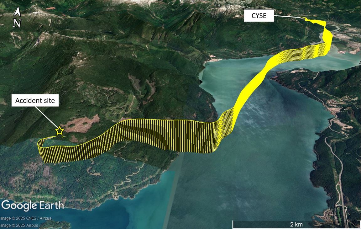
The aircraft departed Runway 15 at approximately 1708.All times are Pacific Daylight Time (Coordinated Universal Time minus 7 hours). It followed the approximate path of the Squamish River southbound, climbing just above 2200 feet above sea level (ASL) before it began a descent. It then flew between 1600 and 1550 feet ASL, making several course changes while travelling southwest.
At approximately 1716, the aircraft resumed climbing. It passed 2400 feet ASL and made an 80° heading change to the west. The aircraft had been following Howe Sound southbound and was now flying toward rising terrain.
The aircraft performed a left turn and then a right turn while it continued to climb, reaching approximately 2800 feet ASL before it began a descent. The aircraft descended for 28 seconds and then climbed for 11 seconds at a rate of almost 1500 fpm. The aircraft’s ground speed reduced from approximately 81 knots to 50 knots during the climb.
At approximately 1720, the aircraft entered a descending, accelerating right turn that resulted in a course reversal of more than 180°. The bank angle is estimated to have been greater than 30°. The aircraft’s ground speed then increased from approximately 50 knots to 113 knots while the aircraft descended at a rate of more than 1800 fpm.
The aircraft impacted terrain at an elevation of approximately 2600 feet ASL on an east-northeast heading (Figure 1). Both aircraft occupants were fatally injured. The aircraft was destroyed. There was a post-impact fire, with minimal damage to the environment.
Pilot information
The pilot held a private pilot licence – aeroplane, issued on 05 November 2021, and a valid Category 3 medical certificate. At the time of the occurrence, he had accumulated approximately 310 hours total flight time and approximately 230 hours of flight in the occurrence aircraft.
The pilot did not hold an instrument rating. Training records indicate that the pilot had 5 hours of instrument flight training experience, which is the minimum required to hold a private pilot licence. The last time he had practised flying with reference to aircraft flight instruments was in September 2021. There are no instrument currency requirements for VFR-rated private pilots.
The investigation determined that all the pilot’s instrument training had been conducted using a vision blocking device worn to obstruct the view outside the aircraft while flying with reference to instruments. The pilot did not have any documented experience in actual instrument meteorological conditions (IMC), or any documented instrument flight simulator training, nor was he required to.
According to information gathered during the investigation, there was no indication that the pilot’s performance was affected by medical, physiological, or pathological factors.
Meteorological information
The investigation determined that the pilot had declined a pre-flight weather briefing offered over the phone by a NAV CANADA flight service specialist, and that he did not conduct a weather briefing or retrieve weather information via electronic flight planning software on his personal tablet. The pilot may have retrieved weather from other sources, such as the internet, but that information was not available to the investigation. As a result, the investigation was unable to determine what weather information the pilot had obtained before departure.
The Clouds and Weather chart from the graphic area forecast applicable to the occurrence flight was issued at 1625 (43 minutes before departure) and became valid at 1700 (8 minutes before the time of departure). It indicated generally VFR conditions along the route of flight; however, there were patchy areas of low cloud with ceilings from 600 to 1200 feet ASL and localized areas with:
- Ceilings as low as 300 feet above ground level (AGL)
- Visibility as low as 1 statute mile
- Light rain
- Mist
The nearest aviation weather observation to the occurrence location that included a ceiling and visibility report was the aerodrome routine meteorological report taken at Vancouver International Airport (CYVR)CYVR is located approximately 24 nautical miles (NM) south of the occurrence location. and issued at 1700, approximately 20 minutes before the occurrence. It indicated the following conditions:
- Winds from 140° true at 6 knots
- Visibility of 6 statute miles
- Light rain
- Mist
- Broken ceiling at 700 feet AGL
- Overcast cloud layer at 2000 feet AGL
- Temperature 11 °C and dew point 11 °C
- Altimeter setting 29.83 inches of mercury
The weather stations closest to the occurrence, located at Port MellonPort Mellon is located approximately 8.5 NM west-southwest of the occurrence location. and Howe Sound-Pam RocksHowe Sound-Pam Rocks weather station is located approximately 6.5 NM south of the occurrence location. indicated calm winds during observations recorded approximately 20 minutes before the occurrence.
Pilot reports from 2 aircraft flying in the Howe Sound area approximately 1 hour and 2 hours, respectively, after the occurrence reported ceilings of 1100 feet ASL and 900 feet ASL. Approximately 2 hours and 30 minutes after the occurrence, ceilings at the occurrence site were reported to be 1500 to 1700 feet ASL. All reported ceiling heights near the occurrence location in the hours after the occurrence were lower than the elevation of the accident site, and search and rescue air assets were unable to land in the vicinity of the site as a result.
The entirety of the occurrence flight was conducted at an altitude below the freezing level; airframe icing is not considered to be a factor in the occurrence.
Aircraft information
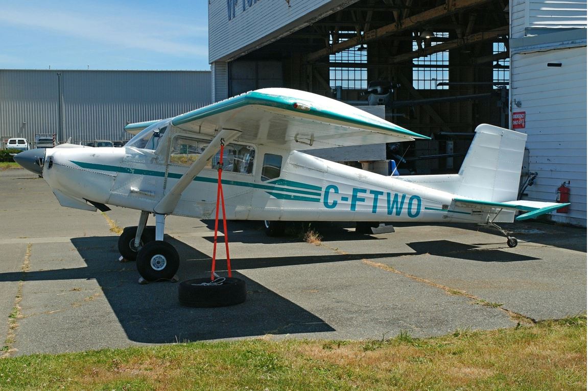
The occurrence aircraft was an amateur-built Murphy Rebel manufactured in 2000. It was equipped with a Franklin Aircraft Engines 4A-235-B31 reciprocating piston engine and a metal, fixed-pitch propeller (Figure 2). The aircraft was not equipped for flight under instrument flight rules.
The aircraft was imported from the United States to Canada in 2017. At the time of import, the aircraft had flown approximately 179 total hours. The investigation could not determine the aircraft’s total air time at the time of the occurrence because the pilot discontinued documenting the air time of each flight, as well as the cumulative total air time of the aircraft, in the aircraft journey logItem 4 of Schedule I (subsection 605.94(1)) of the Canadian Aviation Regulations requires pilots to enter the “[a]ir time of each flight or series of flights and cumulative total air time […] since date of manufacture” into the aircraft journey log. in July 2022.
Before the flight, the aircraft was fuelled with 60 L of 100LL aviation gasoline. The total volume of fuel onboard the aircraft at the time of the occurrence is unknown; however, the flight plan filed before the occurrence flight indicated 3 hours of endurance.An endurance of 3 hours was calculated to require approximately 78 L of aviation gasoline, assuming 15 minutes at climb power and 2 hours and 45 minutes at cruise power settings.
The aircraft technical records indicate the last annual maintenance inspection was performed on 20 February 2023. At the time of the occurrence, the aircraft was overdue for its subsequent annual maintenance inspection by 94 days.
The occurrence aircraft was not certified for flight in IMC.
Aircraft engine and flight controls
The occurrence aircraft’s engine was sent to the TSB’s facility in Richmond for examination. Damage to the starter gear was discovered. The starter gear extends and drives the accessory gearing during engine starts. It is retracted during flight. At impact, it was driven forward by inertia, and it was marred by the rotating gears of the accessory drive, indicating that the engine was producing sufficient power to drive its accessory gearing at the time of impact.
Engine air-intake manifolds all showed signs of ductile deformation as a result of impact forces, consistent with heat within the engine cowling at the time of impact.
Engine rotation at impact was determined to be approximately 2700 rpm based on an imprint produced by contact between the rpm needle and the instrument gauge face at impact. The maximum rated rpm of the engine is 2800.
The engine examination uncovered no suspected pre-impact abnormalities and found multiple indications that the engine was running when the aircraft collided with the terrain.
Flight control continuity could not be established because all control surfaces were separated from the aircraft during the crash sequence and were substantially damaged.
There were no signs of pre-impact mechanical failure or system malfunction.
Spiral dive
A spiral dive or spiral can be defined as “a steep descending turn in which airspeed, rate of descent, and wing loading increase rapidly.”Transport Canada, TP 1102E, Flight Training Manual - Aeroplane, 4th edition (revised August 2004), Exercise Fourteen, p. 85.
In its Airplane Flying Handbook, the U.S. Federal Aviation Administration (FAA) states that ”[p]ilots typically get into a spiral dive during an inadvertent IMC encounter, most often when the pilot relies on kinesthetic sensations rather than on the flight instruments.”Federal Aviation Administration (FAA), FAA-H-8083-3C, Airplane Flying Handbook (2021), Chapter 5, p. 5-26.
In addition, the FAA’s Pilot’s Handbook of Aeronautical Knowledge indicates:
The results of the prolonged uncontrolled spiral are inflight structural failure, crashing into the ground, or both. Common recorded causes for pilots who get into this situation are loss of horizon reference, inability to control the aircraft by reference to instruments, or a combination of both.Federal Aviation Administration (FAA), FAA-H-8083-25C, Pilot’s Handbook of Aeronautical Knowledge (2023), Chapter 5, p. 5-20.
Before impacting terrain, the occurrence aircraft’s flight path was consistent with the characteristics of a spiral.
Wreckage and impact information
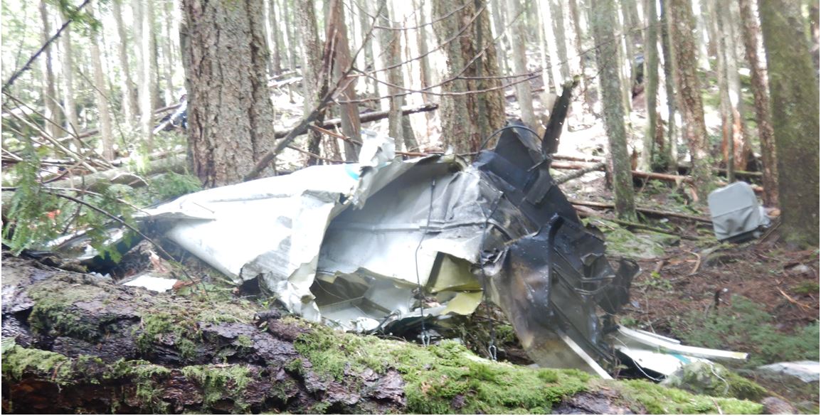
The aircraft wreckage was found in a heavily forested area with mountainous, uneven terrain. The aircraft wreckage exhibited signs of a high-energy impact and was found broken up along a 111 m (approximately 364 feet) linear debris trail. Wreckage was consistent with a spiral dive arrested by terrain. The occupiable space within the aircraft was compromised (Figure 3). Investigators were able to confirm that control and lifting surfaces were intact until contact with trees and terrain. The accident was not survivable.
Search and rescue
The occurrence aircraft was equipped with an automatic fixed emergency locator transmitterThe emergency locator transmitter was an ACK Technologies, Inc. E-04. capable of transmitting on frequencies 121.5 MHz and 406 MHz. The transmitter functioned as intended, alerting the Canadian Mission Control Centre of the occurrence at approximately 1721.
A cellular phone, equipped with a crash-detection feature, was also carried on board the aircraft. This phone feature automatically placed an emergency service call in response to detecting that the device had been in a severe crash. It also sent a notification to the emergency contacts of the device owner. As a result, friends and family of the aircraft occupants became aware of the occurrence concurrently with search and rescue (SAR) services.
The Joint Rescue Coordination Centre in Victoria dispatched a C-130 Hercules aircraft and a CH-149 Cormorant (Cormorant) helicopter to the site of the occurrence. A civil SAR helicopter operated by the British Columbia Search and Rescue Association was also dispatched to the area.
Some recipients of the pilot’s phone crash notification elected to fly to the occurrence location and did so in a civilian Aerospatiale AS350 B2 helicopter (AS350) while SAR operations were in progress.
With respect to avoidance of SAR areas, the Canada Flight Supplement (CFS) states:
It has been reported that pilots of private and commercial aircraft, not under the control of the Canadian Forces during air searches, are seriously interfering with and jeopardizing the safety of aircraft engaged in search operations.
Such interference is occasioned by pilots flying unnecessarily through the search area […].
In the interest of safety, and efficient search and rescue operations, pilots of aircraft not engaged in this activity are to avoid airspace in the area specified by NOTAM whenever possible. Extreme caution should be exercised whenever it is necessary to enter this airspace.NAV CANADA, Canada Flight Supplement (CFS) (effective 16 May 2024 to 11 July 2024), Emergency, p. F7.
The AS350, carrying 3 passengers in addition to the pilot, was not involved in official SAR efforts. Although no NOTAM was issued, the investigation determined that the pilot was aware of the SAR operations taking place in the vicinity of the occurrence location before undertaking the flight to travel there.
After arriving in the SAR area of operations, the AS350 helicopter became a traffic conflict for the Cormorant. The AS350 was reportedly operating at the same altitude and flying directly toward the Cormorant already in the area. The crew of the Cormorant elected to depart the search area and moved approximately 1 mile away for their own safety because communication could not be established with the AS350 on CYSE’s traffic frequency,CYSE’s traffic frequency is 122.8 MHz. nor on 123.2 MHz, which is reported to be commonly used in the Howe Sound area. The investigation determined that neither helicopter was monitoring 126.7 MHz.
Without communicating with the Cormorant, the AS350 landed near the occurrence location, depositing 1 of the 3 passengers on the ground. The Cormorant subsequently established radio communication with the AS350’s pilot and instructed him to leave the area. The AS350 departed, but the pilot did not communicate during its departure or indicate that it was clear of the area.
SAR operations were called off when it was reported that the occupants of the occurrence aircraft had not survived the accident.
TSB laboratory reports
The TSB completed the following laboratory reports in support of this investigation:
- LP094/2024 – Aircraft Track Superimposed Over Terrain
- LP100/2024 – NVM Data Recovery – PEDs and Radio
Safety messages
Pilots are reminded that flying VFR in marginal weather conditions, such as low ceilings, is challenging, especially when flying in and around mountainous terrain. Pilots need to consider strategies to avoid adverse weather, as well as have plans should such weather be encountered. VFR flights that continue into IMC often result in a fatal collision with terrain or a loss of control due to lost visual references.
Pilots of aircraft not engaged in SAR operations are reminded to avoid SAR areas or exercise extreme caution whenever it is necessary to enter them, in accordance with the CFS guidance.
It is essential that pilots participate in radio communications with nearby aircraft for the purpose of avoiding collision, especially so in areas where SAR operations are taking place.
This report concludes the Transportation Safety Board of Canada’s investigation into this occurrence. The Board authorized the release of this report on 04 June 2025. It was officially released on 10 July 2025.


