Capsizing with loss of life
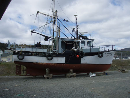
Small fishing vessel Le Marsouin I
Off Riviere-au-Renard, Quebec
The Transportation Safety Board of Canada (TSB) investigated this occurrence for the purpose of advancing transportation safety. It is not the function of the Board to assign fault or determine civil or criminal liability. This report is not created for use in the context of legal, disciplinary or other proceedings. See Ownership and use of content. Masculine pronouns and position titles may be used to signify all genders to comply with the Canadian Transportation Accident Investigation and Safety Board Act (S.C. 1989, c. 3).
Summary
On 18 May 2009 at approximately 1739 Eastern Daylight Time, the small fishing vessel Le Marsouin I, with a crew of three on board, capsized while navigating in slight to moderate quartering seas off Riviere-au-Renard. One deckhand was rescued by the Canadian Coast Guard shortly afterward. The bodies of the master and the second deckhand were recovered later.
Factual information
Particulars of the vessel
| Name of vessel | Le Marsouin I (formerly Sylvia C) |
|---|---|
| Official number | 395338 |
| Port of registry | Gaspe, Quebec |
| Flag | Canada |
| Type | Small fishing vessel |
| Gross tonnage | 24.58 |
| Overall lengthFootnote 1 | 14.07 m |
| Registered length | 13.14 m |
| Waterline length | 12.95 m |
| Built | 1981, Saint-Antoine-de-Tilly, Quebec |
| Propulsion | One 130 kW diesel engine driving a fixed-pitch propeller |
| Cargo | Approximately 90 empty plastic fish totes |
| Crew | 3 |
| Registered owner | Private owner, Forillon, Quebec |
Description of the vessel
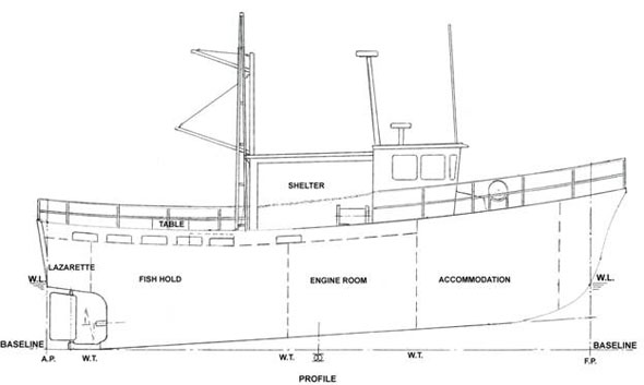
Le Marsouin I is the fifth of a series of 11 similarly built vessels constructed between 1980 and 1983. The vessel is of closed construction with a moulded hull built of glass-reinforced plastic. The hull is subdivided by three transverse bulkheads enclosing (from forward) the accommodation, the engine room, the fish hold, and a lazarette. The wheelhouse is located on the main deck forward from midships; access to the wheelhouse from the afterdeck is through a sliding door fitted with a sill on the starboard side facing aft, and access to the foredeck is through a hinged door on the port side of the wheelhouse. In the wheelhouse, the engine room and the accommodation are accessed through a flush-deck hatch on the port side and a companionway, respectively (see Appendix A).
The afterdeck is surrounded by a bulwark fitted with freeing ports at deck level, six on each side. At the time of the occurrence, the freeing ports on the port side were fitted with covers which were closed and locked to prevent the catch from going overboard. The afterdeck is partly covered by a shelter aft of the wheelhouse. A hatchway on the centreline, fitted with a coaming and a cover, provides access to the fish hold; access to the lazarette is through a flush manhole on the afterdeck.
The vessel is used primarily to catch ground fish, but also fishes for crab. The vessel is equipped with paravane booms, a wooden crab-sorting table, and a stern platform. Mechanical equipment on deck includes a trap hauler, a crab block, and a cargo boom.
A fuel oil tank is located on each side of the engine room, with a fresh water tank below the accommodation.
Eighty kilograms of rocks were secured below the accommodations and 312 kg of various materials which serve as solid ballast were stowed unsecured in the lazarette.Footnote 2
Le Marsouin I carries a six-person liferaft located on the foredeck of the vessel. The raft was equipped with both a hydrostatic release and a senhouse slip. In addition, there are four lifejackets, four immersion suits, two lifebuoys, and a float-free emergency position-indicating radio beacon (EPIRB) fitted with a hydrostatic release unitFootnote 3 located on top of the wheelhouse.
The vessel also has two VHF radios, one of which was fitted with digital selective calling (DSC)Footnote 4 capability and had an assigned Maritime Mobile Service Identity (MMSI) number. Both radios are attached to the wheelhouse deckhead.
History of the voyage
In the early morning of 18 May 2009, the master and two deckhands assembled on Le Marsouin I in the port of Grande-Greve, Quebec, to prepare for a crab fishing trip. By 0645,Footnote 5 the vessel was underway and proceeding to the crab fishing grounds approximately 1.5 nautical miles (nm) off shore. The vessel had a small inherent starboard list.
Some 35 crab pots were hauled aboard. Their contents, weighing approximately 1800 kg, were placed in plastic fish totes before being stowed in the fish hold. At 1300, the vessel departed the fishing grounds to offload the catch in Riviere-au-Renard, Quebec. After discharging the catch, the fish hold was washed and the water pumped out. This left the hold and the lazarette, which drained into it, empty. The fish hold hatch was secured and all six flush deck scuttles were closed tight. About 90 empty fish totes were stacked on deck and secured with the sorting table.
At approximately 1720, Le Marsouin I departed Riviere-au-Renard for the return trip to Grande-Greve. The vessel's speed was about 8 knots on a heading of 135° True (T) to make way parallel to the shoreline approximately one mile off shore, where water depth is approximately 50 m. The vessel's anti-roll paravane booms were stowed in the upright position, and the fuel oil tanks were partially filled. Winds were light from the northeast accompanied by quartering seas of 1 m.Footnote 6 The vessel was experiencing slight rolling and pitching. A week prior to the occurrence, the vessel had experienced a sudden and severe unexplained roll under similar operating circumstances.
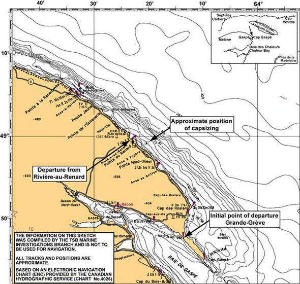
The master was standing near the wheel, with deckhand B to his left. Deckhand A was standing by the closed sliding door. At approximately 1738, the vessel briefly heeled to starboard before returning to its upright position, only to heel once again-this time even further to starboard. Following a warning from the master that the vessel was going over, deckhand A opened the sliding door and exited the wheelhouse. The vessel continued to heel to starboard and capsized in position 48°59.3′ N, 064°19.6′ W (See Appendix B).Footnote 7
Search and rescue
The capsizing was sudden, and no Mayday call was made. No lifesaving equipment was used. Once in the water, deckhand A swam from under the overturned vessel and surfaced near the stern, eventually climbing onto the overturned hull near the rudder.Footnote 8 The position of the rudder was near midships.
At approximately 1740, a resident on shore noticed the capsized vessel and called the police, who in turn alerted the Marine Rescue Sub-Centre (MRSC) in Quebec, Quebec. The MRSC tasked search and rescue (SAR) resources, including the Canadian Coast Guard ships (CCGS) Cap Rozier, Frederick G. Creed, and Martha L. Black. The CCGS Cap Rozier, based out of Riviere-au-Renard, sent its fast rescue craft (FRC) to the scene of the accident and, at 1756, deckhand A was recovered. Shortly thereafter, he was transferred to an ambulance ashore.
At 1757, MRSC Quebec requested SAR air resources from the Joint Rescue Coordination Centre in Halifax, Nova Scotia. An aircraft and helicopter were tasked, as well as three local fishing vessels. Arrangements were also made for local divers to search the vessel. The CCGS Cap Rozier's FRC brought two local divers on scene and, at approximately 1900, the body of deckhand B was recovered by the divers from inside Le Marsouin I. Despite another dive attempt, the master's body was not located, and further dives were not carried out due to significant debris within the vessel.
SAR efforts continued while the overturned vessel was towed back to Riviere-au-Renard. The master's body was found the next day within the vessel.
Damage to the vessel
Le Marsouin I suffered extensive water damage to the engine, the control systems, and electronics. The starboard paravane boom was broken, and the starboard aft bulwark was buckled.
Injuries to persons
Deckhand A was treated for shock and mild hypothermia before being released from hospital. The master and deckhand B drowned.
Environmental damage
A small amount of oil was released as a result of the capsizing, but it was quickly dissipated by evaporation and the wind/wave action. Impact to the environment was deemed negligible.
Vessel history
Le Marsouin I was originally constructed as a multipurpose fishing vessel and fitted with a mizzen mast and riding sail. None of the 11 vessels in the series underwent a full stability assessment following construction, nor was one required by regulation.
In the years since its construction, Le Marsouin I was subject to the following modifications: the removal of the mizzen mast and sail; the installation of stabilizer booms, a trap hauler, a crab block, a cargo boom, and a platform fitted above the bulwark and extending beyond the stern that was used for fishing operations and storing gear.
During the previous 9 years, Le Marsouin I had been used for crab fishing in the spring and then for ground fishing. The vessel made, on average, 10 short crab fishing voyages per season, predominantly around the Gaspe Peninsula. After discharging the crab, the vessel would typically leave Riviere-au-Renard in a light condition-i.e., with the fish hold empty, as in this case. The capsizing occurred during the vessel's eighth voyage that season.
No stability data were available at the time of the occurrence, nor was this required by the Small Fishing Vessel Inspection Regulations (SFVIR) during the vessel's lifespan.
It is not known, nor could it be determined, if the vessel was modified or solid ballast removed before the 2009 season. A review of the vessel's records held by Transport Canada (TC) indicated no previous stability issues.
Vessel certification
On 03 May 2006, Le Marsouin I was issued an Inspection Certificate for a Commercial Fishing Vessel not exceeding 150 Gross Tonnage for Class II Home Trade voyages. The inspection certificate was to expire on 02 May 2010. During the inspection the owner completed TC's Stability Information Questionnaire form, a document to identify specific risk factors and help determine if a vessel requires a stability booklet.Footnote 9
Stability questionnaire and assessment
A stability assessment is not required by current regulations for existing small fishing vessels, unless they are employed in catching herring or capelin. TC is developing the new Fishing Vessel Safety Regulations, which propose to expand the application of the vessel stability requirements.Footnote 10 It is anticipated that these will be pre-published in the Canada Gazette, Part I, by the end of 2011.
In the interim, TC has established a policy to determine if small inspected fishing vessels over 15 gross tons would benefit from a stability booklet. The decision to have such a document is based on the identification of specific risk factors, as listed in the Stability Information Questionnaire.Footnote 11 These risk factors also apply to uninspected small fishing vessels, given that the risk associated with their operation is similarly high. The questionnaire, however, is not a comprehensive list of all possible risk factors; to this end, the accompanying Ship Safety Bulletin (SSB) notes that although a working knowledge of a vessel's stability limits can also be developed over time "by observing how it handles in different conditions … to really understand a vessel's safe operating capabilities, a [formal assessment] is needed."
The owner of Le Marsouin I completed this questionnaire in May 2006, at which time it was presented to TC. As no risk factors had been identified, no stability booklet was deemed necessary.
Personnel certification and experience
The owner, who had been master of Le Marsouin I since purchasing it in 1986, had approximately 40 years' experience on fishing vessels and had travelled this route many times previously. He held a Marine Emergency Duties (MED) certificate. He possessed no certificate of competency, nor was one required by regulation.
Deckhand A had approximately one year of experience on fishing vessels and two years' experience on barges in the Arctic. He had served as deckhand on this vessel for three weeks. Deckhand B had approximately six years' experience on fishing vessels.
Neither deckhand held a marine certificate, although at least one was required to hold MED certification prior to completing six months cumulative sea service.Footnote 12
Weather conditions
The nearest sources of weather information were a buoy near Mont-Louis, Quebec, and a shore station at Cap-Madeleine, Quebec. These were 65 and 43 nm, respectively, west of the occurrence site.Footnote 13 In the late afternoon of 17 May 2009, the day before the occurrence, both of these sources registered westerly winds of 10 to 18 knots. Wind conditions remained the same until the occurrence the following afternoon at 1700, when they were reported at 12 to 15 knots. At 1800, the CCGS Cap Rozier reported an on-scene wind speed of 10 knots from the northeast.
Minimum and maximum significant wave heightsFootnote 14 for the Mont-Louis buoy were recorded as 0.4 m and 1.4 m respectively on 17 May 2009. These increased to 0.8 m and 1.4 m on 18 May 2009. At the time of the occurrence, the maximum wave height was recorded as 1.8 m. At 1800, the CCGS Cap Rozier crew observed an on-scene maximum wave height of 1.5 m.
Vessel stability in calm water
A few days after the occurrence, the TSB carried out a lightweight surveyFootnote 15 and an inclining test in order to determine the vessel's lightship characteristics. A computer model was prepared from the lines plan, and hydrostatics and cross curves were also produced. The vessel's stability was then assessed against criteria found in STAB 4 (for fishing vessels)Footnote 16 for the following loading conditions:
- lightship (based on the results of the inclining test)Footnote 17
- departure after unloading (75% fuel and water, no waves)Footnote 18
In the lightship condition, STAB 4's only applicable criterion is the minimum metacentric height (GM) which the vessel met.
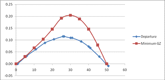
In the departure condition after unloading the crab and with no wave action (i.e., dockside in calm water), the vessel's stability did not meet the majority of the STAB 4 criteria. For instance, the area under the righting arm (GZ) curve at 30° of heel was only 70% of the STAB 4 minimum; at 40°, it was 61%. The initial stability was also slightly further reduced on starboard side as the vessel had a slight list on that side (see Table 1 and Appendix D - Graph 1).
| Minimum criteria | Actual values from conditions | ||
|---|---|---|---|
| Lightship | Departure | ||
| GM upright, in m (in ft) | 0.35 (1.15) | 0.36 (1.19) | 0.38 (1.24) |
| Righting arm at 30 deg, in m (in ft) | 0.2 (0.66) | n/a | 0.11 (0.36) 55% |
| Absolute angle at max RA, in deg | 25° | n/a | 26.5° |
| Area from 0 to 30 deg or flood, in m-deg (in ft-deg) |
3.15 (10.34) | n/a | 2.20 (7.21) 70% |
| Area from 30 to 40 deg or flood, in m-deg (in ft-deg) |
1.72 (5.64) | n/a | 0.85 (2.80) 49% |
| Area from 0 to 40 deg or flood, in m-deg (in ft-deg) |
5.15 (16.91) | n/a | 3.15 (10.33) 61% |
Shaded areas are not compliant with the STAB 4 minimum criteria
Angle and period of encounter between vessel and wave
Video footage taken during SAR activities, some 30 minutes after the capsizing, shows slight to moderate seas with a wave height of 0.5 m to 1 m. Waves were estimated as coming from 320° (T) to 350° (T). Given that the vessel's heading was approximately 135° (T), the angle of encounter relative to the ship's heading would have been anywhere between 145° and 175° on the port quarter (see Appendix C - Table 1). This corresponds to following and quartering seas.
Additionally, the wave periodFootnote 19 was estimated at 3 to 4.5 seconds. This corresponds to wave lengthsFootnote 20 of 14 m to 32 m, and wave speedsFootnote 21 of 9 to 14 knots (see Appendix C - Table 2). The period of encounter for the vessel in these conditions would have been between 9 and 26 seconds.Footnote 22 The longer the period of encounter, the greater the time it takes for a wave to pass along a vessel's hull.
Following and quartering seas
Following and quartering seasFootnote 23 can potentially threaten vessel stability, with the two principal dangerous phenomena being surfing and broaching. In such conditions, a vessel encounters waves for a longer period than on the beam or bow. In beam seas, the buoyancy is modified transversally; and in bow or stern seas, the buoyancy is modified longitudinally. However, in quartering seas, the buoyancy is modified in both directions. This uneven distribution causes transitory and occasionally marked reductions in stability.
Factors affecting vessel stability in waves
Following the occurrence, the TSB assessed the vessel's stability in waves (departure condition) by varying the following parameters:
- position of wave crest along the hullFootnote 24
- wave height (0.5 m, 1.0 m, and 1.5 m)
- ratio of wave height to length (1:15, 1:20, 1:25, 1:30), at wave lengths of 14 m, 18 m, 23 m, and 27 m
- angle of encounter from the longitudinal axis at the after end (0°, 22.5°, and 45°)
These parameters were chosen to reflect various wave conditions at the time of the occurrence. Calculations were based on the quantity/distribution of weights on board at departure. In order to provide some comparison, and noting the absence of a standard for dynamic stability,Footnote 25 the effect of these parameters on the vessel's stability is compared with the GZ curve in the departure condition in calm waters and also with the minimum STAB 4 criteria.
Each of these parameters is discussed in detail below.
Wave position
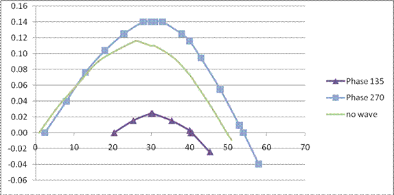
GZ curves were produced for various positions of a wave crest along the hull (see Figure 1). These assumed an average wave height of 0.9 m (3 ft) and a 45° angle of encounter (from the longitudinal axis after end). These were then compared against a condition where there were no waves. Results show that stability in waves was less than when no waves were present, except for a wave phase of 270°. At this phase, the righting lever amounts to 71% of the STAB 4 minimum, and the range of positive stability is 54°. The worst-case condition occurs at the wave phase 135°, wherein the area under the GZ curve represents just 6% of the STAB 4 minimum and the range of positive stability is only 20°. This corresponds to an angle of vanishing stability of 40° (see Appendix D - Graph 2).
Wave height
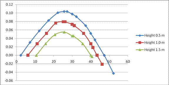
GZ curves were also produced for three different wave heights (0.5 m, 1.0 m, 1.5 m). Results show that the area under the GZ curve was 60%, 40%, and 24%, respectively, of the STAB 4 minimum between 0° and 30° of heel (see Appendix D- Graph 3).
Ratio of wave height to wave length
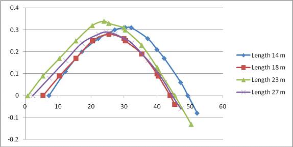
GZ curves were again produced for various wave height/length ratios, assuming a wave phase of 90° but using an angle of encounter of 20° (from the longitudinal axis after end). For angles of heel between 0° and 40°, the area under the GZ curve was between 38% and 52% of the STAB 4 minimum, depending on the ratio (see Appendix D - Graph 4).
Angle of encounter
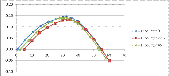
Using the best-case condition of wave phase 270°, GZ curves were produced for three different angles of encounter: broad on the stern to quartering seas (i.e., between 0°, 22.5°, and 45° from the longitudinal axis after end). A comparison between these GZ curves for these angles indicated no significant variation (see Appendix D - Graph 5).
Surfing and broaching
The International Marictime Organization (IMO) has recognizedFootnote 26 that surfing and broaching may occur when a vessel is in following and quartering seas and its speed exceeds a certain value.
Surfing
When a vessel is situated on the steep forefront of a high wave in following and quartering seas, the vessel can be accelerated so as to ride or "surf" on the wave. This can substantially reduce intact stability according to the changes in the submerged hull form,Footnote 27 and can become critical in the following situations:
- wave length is between 1 to 2.5 times vessel waterline length
- vessel is moving at wave speed plus or minus 10%Footnote 28
- vessel has a slight bow-down pitch attitude, with a wave crest abaft amidships.
In this occurrence, the estimated wave length (14 mto 32 m) and wave speed (9 to 14 knots) were within the critical range in relation to the vessel's waterline length (12.95 m) and speed (approximately 8 knots). In addition, as indicated in the section on “Wave Position”, the worst-case scenario for vessel stability was at phase 135°, which is representative of a wave crest abaft amidships.
Warning signs for surfing include:
- large variations in vessel speed at constant throttle
- response to steering controls is poor
- breaking waves increase the tendency to surf.
Given the risks associated with surfing, standard corrective action can include reducing speed or changing course.
Surfing may also be the precursor of another phenomenon, known as broaching.
Broaching
Broaching is a severe, and often uncontrollable, yawingFootnote 29 movement which turns the vessel beam on to the waves, resulting in a sideways sliding motion down-sea. This creates a risk of capsizing if there is also a sudden change in the vessel's heading or extreme heeling,Footnote 30 especially if the vessel is not able to keep constant course.Footnote 31 Although broaching is often associated with heavy seas, it can also occur in more moderate wave conditions.
For broaching to occur, certain factors must be present, including as in this case-waves which come from behind and propagate in a direction forming a small angle (e.g., 10° to 30°) from the longitudinal axis at the vessel's aft end.Footnote 32
Other risk factors for broaching includeFootnote 33:
- a wavelength similar to, or slightly shorter than, the vessel's waterline lengthFootnote 34
- vessel moving at wave speed plus or minus 15%
- a wave height greater than 4% of the vessel's waterline length
- a bow-down attitude with the bow burying into wave ahead
In this occurrence, three of these conditions were present: vessel speed was similar to wave speed, wave height was greater than 4% of the vessel's waterline length, and the waves were propagating in a small angle from the longitudinal axis at the vessel's aft end. (Wave length was also similar to the waterline length, but to a lesser extent.)
Previous occurrences
In a previous occurrence in 1990 involving the disappearance and presumed sinking of the fishing vessel Le Bout de Ligne,Footnote 35 the Board noted that the existing stability criteria did not reflect the actual sea conditions in which the dynamic effects of wave-induced motion, wind, swell and vessel speed could have a pronounced effect on the reserve stability of small fishing vessels. For example, the actual righting moment of a vessel on a wave crest is substantially less than that in calm water as set out in the current stability criteria. In addition, ship motions in following and quartering seas generate additional dynamic heeling or capsizing forces.
In a 2007 occurrence involving the capsizing of the small fishing vessel Sea Urchin,Footnote 36 the TSB's post-occurrence stability analysis revealed that, during the voyage, the lightly loaded vessel's reserve of transverse stability did not meet the minimum criteria of STAB 4. The deficient stability was further affected by the dynamic effects of the quartering seas.
Regulatory stability criteria are based on static water surfaces. In practice, however, the distribution of buoyant support varies as wave crests pass under or along a vessel's hull, causing transitory and occasionally marked reductions in stability.
Analysis
Vessel stability
The TSB's post-occurrence stability assessment revealed that, at departure condition, the vessel's reserve of transverse stability did not meet the minimum criteria of STAB 4. At an angle of heel of 30°, for example, the vessel possessed just 70% of the standard, and just 61% at 40°. The following factors were involved:
- the vessel was in a light condition, with neither catch nor ice aboard;
- there was little permanent ballast;
- the fuel tanks were partially filled and thus subject to free surface effects; and
- the vessel had a small inherent starboard list, reducing its initial stability if heeled over on that side.
The STAB 4 standard, however, assumes a vessel is in calm waters. In waves, the TSB assessment revealed that Le Marsouin I's stability was even further reduced in all cases except one, and that the vessel was experiencing large variations of its righting lever. Even for the most optimistic scenario-with a wave phase of 270°-stability was just 71% of the STAB 4 standard. By contrast, at 135°-i.e., with the vessel's midships just forward of the wave crest-stability was a mere 6% of the standard. At this point, calculations show that the vessel's angle of vanishing stability was just 40°. Moreover, in a dynamic environment, vessel stability at such a large angle of heel may have been further reduced by the following factors:
- shifting of the unsecured ballast
- water that was shipped and retained on deck due to the portside freeing ports being closed and locked.
As such, in its departure condition, the vessel had limited stability, even in calm waters. Once underway in the presence of following and quartering seas, the vessel's stability was further reduced.
Undoubtedly the vessel would have encountered similar conditions during its 18 years of operation and while under control of the master during the last 13 years. It is possible that further modifications had recently been made to the vessel that had a detrimental effect on its stability, however, this could not be determined by the investigation.
Conditions for surfing and broaching
The interaction between a vessel and its environment is complex. Following and quartering seas, for example, can lead to surfing and broaching even under conditions that appear benign. Additionally, a vessel's speed and heading relative to waves will also influence its response.Footnote 37
With respect to these phenomena, which are not widely understood, there are numerous factors that can both affect surfing and broaching, including: period of encounter, wave length, vessel speed, and wave height (see Table 2).
Period of encounter
In this occurrence, the vessel's period of encounter with the waves was between 9 and 26 seconds; this relatively low frequency would have meant a relatively long period of encounter between vessel and wave, and thus a higher risk of surfing.
Wave length
When the wave length is between 1 to 2.5 times a vessel's waterline length, there is an increased risk of surfing. Figure 3 shows that, in this occurrence, the wave length was within this critical range and, to a much lesser extent, also within the critical range for broaching.
Vessel speed
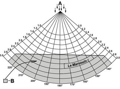
For surfing to become critical, a vessel must be moving at wave speed plus or minus 10% (plus or minus 15% for broaching). In this occurrence, the vessel's speed was 8 knots, and the wave speed was between 9 and 14 knots. The table in Appendix E shows that, once consideration has been given to the angle of encounter, there was a moderate risk of surfing when the wave speed was 9 to 10 knots, and a slightly greater risk of broaching when the wave speed was 9 to 11 knots.
Furthermore, Appendix F shows the relative position of the vessel within the area where existed a risk for surfing.
Wave height
Surfing and broaching can occur when wave height is greater than 4% of the vessel's waterline length. The vessel's waterline length was 12.95 m, and wave height 30 minutes after the occurrence was observed between 0.5 and 1 m-or between 4% and 8% of the waterline length. This meant the vessel could have experienced both surfing and broaching.
| Surfing | Broaching | |||||
|---|---|---|---|---|---|---|
| Critical interactive conditions | Occurrence condition | Occurrence level of risk | Critical interactive conditions | Occurrence condition | Occurrence level of risk | |
| Period of encounter (s) | PE >> PW | 9 to 26 >> 3 to 4.5 |
high | n/a | n/a | n/a |
| Wave length (m) | Lw ~ 1 to 2.5 Ls |
14 to 32 ~ 13 to 32 |
high | Lw ~ Ls | 14 to 32 ~ 11 to 15 |
low |
| Vessel speed (knots) | VS ~ Vw ± 10 % |
8 ~ 6.64 to 15.34 |
moderate | VS ~ Vw ± 15 % |
8 ~ 6.26 to 16.04 |
moderate |
| Wave height (m) | Hw > 4 % | 0.5 to 1.0 > 0.52 |
moderate | Hw > 4% Ls | 0.5 to 1.0 > 0.52 |
moderate |
In summary, the conditions were therefore present for the vessel to experience surfing and, to a lesser extent, broaching. Given that there was no steering difficulty prior to the capsizing, it is less likely that broaching was involved.
As previously noted, the vessel's stability was reduced in waves, particularly when surfing-a condition in which stability was just 6% of the STAB 4 minimum. Moreover, given the relatively long period of encounter between vessel/wave, the vessel would have been surfing for longer periods of time. It is therefore likely that, given the dynamic wave environment and the relative angle of encounter, this allowed the vessel to attain a large enough angle of heel such that it reached its angle of vanishing stability and capsized.
Knowledge of sea conditions
The interaction between a vessel and its dynamic environment is complex and can present numerous risks. Masters and crews, therefore, need to be knowledgable about the many weather and sea conditions in which they operate. One such condition is the risk associated with following and quartering seas.
Currently, the IMO highlights the importance of regularly observing the waves-"in particular, the wave period-"in both heavy weather and less severe conditions.Footnote 38 Although an examination of the Canadian syllabi for fishing mastersFootnote 39 reveals no reference to surfing or broaching, there is a section dealing with "heavy weather". This could allow an examiner to address the issue. However, seas in this occurrence were slight to moderate-and yet surfing was nonetheless likely-which emphasizes the IMO guidance that candidates be vigilant even in a variety of sea conditions.
In this occurrence, the master had no formal training beyond a MED certificate. The crew members had no certification. It is therefore not known if the master fully recognized the risks presented by following and quartering seas; however, a week prior to the occurrence the vessel experienced a sudden and unexplained severe roll under similar operating circumstances. Moreover, on the day of the capsizing, no action was taken to mitigate the influence of the following and quartering seas-for example, standard corrective measures such as reducing speed or changing course. This is a possible indication that the crew lacked sufficient knowledge of the risks involved.
In the absence of a detailed awareness of sea conditions, their influence on the vessel, and the appropriate corrective action, masters and crews may unknowingly place themselves and their vessels at risk.
Stability questionnaire
It is vital that masters be fully aware of the operating limits of their vessels. Although a partial sense of a vessel's limits can be developed over time by observing how it handles in different conditions, this is in no way comprehensive or precise.
Currently, masters and operators of small fishing vessels have at their disposal a means to help identify specific risk factors. This Stability Information Questionnairewas completed by the owner of Le Marsouin I in May 2006, at which time it was presented to TC. As the questionnaire identified no risk factors, no stability booklet was deemed necessary.
As a result, and in the absence of any other means to determine the vessel's stability, there exists a risk that a "clean" questionnaire may be taken as an implicit endorsement of adequate stability. As the Board has previously noted,Footnote 40 such a declaration can only be made following a formal stability assessment. Without this, crews may be unaware of their vessel's stability characteristics, possibly compromising safe operation.
Distress communications
In emergency situations, crews of fishing vessels rely on prompt alerting of others to provide assistance. A registered VHF DSC radio represents a reliable means to transmit a distress alert to search and rescue authorities and other vessels within the area which may be in a position to provide immediate assistance. As well, if the vessel is equipped with a GPS receiver, connecting it to a DSC radio will ensure that the vessel's position is automatically sent when the distress alert is transmitted.
In this occurrence, to transmit the distress alert the distress button on the VHF DSC radio had to be pushed and held for four seconds. It is likely the master and crew only realized they were in an emergency situation when the sudden heel to starboard occurred, which precluded the pushing of the DSC distress button or using either VHF radio.
The importance of recognizing such developing situations as early as possible is crucial to ensuring that crews have time to transmit the distress alert. However, given that crews of small fishing vessels spend most of their working time out on deck, it may not always be possible to return to the wheelhouse to transmit a distress alert.
The vessel was also equipped with an EPIRB that was fitted on top of the wheelhouse. Although it was secured to the top of the wheelhouse with a hydrostatic release unit, the EPIRB was still secured in place when the vessel was recovered. The hydrostatic release unit was designed to activate at a water depth of 1.5 m to 4 m. With the vessel in the capsized position, the unit would have been at an approximate depth of 3 m, likely a sufficient depth to activate it and release the EPIRB. In this occurrence, however, this did not happen. The unit was visually examined after the occurrence and it was found to be properly secured. However, the expiry date had been exceeded, thereby increasing the probability that the unit would fail to operate as intended. The importance of replacing safety critical equipment upon their expiration cannot be overstated.
Accessibility / Deployment of lifesaving equipment
When a vessel capsizes rapidly, it is critical that lifesaving equipment be deployed, either manually by the crew, or automatically as the vessel submerges. This is particularly important when a vessel may not be expected to stay afloat for long. In this occurrence, the vessel's liferaft was stowed on the forward deck and was fitted with both a senhouse slip for manual release and a hydrostatic release unit. Despite this, the liferaft did not deploy.
To ensure that lifesaving equipment deploys, two factors must be considered: stowage location and securing arrangements. With regard to the former, challenges are posed by a vessel's size and the limitations imposed by its operational requirements, including:
- A liferaft stowed on an exposed weather deck forward of the accommodation will be subject to wind and waves and can be lost at sea.
- A liferaft stowed high above the weather deck, or on the centreline, may be difficult to launch.
- A liferaft positioned near the side will be difficult to launch if the vessel is heeling in the opposite direction.
Taking into consideration vessel design and layout, options are available to help ensure that liferaft stowage is in an optimum position for ready deployment. These include:
- a cradle design allowing the ready launch of the liferaft clear of the vessel's side
- the provision of a mechanical launch mechanism with minimum maintenance requirements
- the provision of a physical barrier to prevent fouling of the rigging during launch
In this instance, the liferaft did not deploy. It is not known if the hydrostatic release unit was at a sufficient depth to activate, or if it failed to function as designed. Moreover, even if the liferaft had released, its position beneath the capsized vessel may have prevented it from surfacing.
As part of its regulatory reform process, Transport Canada is consulting with industry on the proposed new Fishing Vessel Safety Regulations, which could come into force by 2012. These are expected to address the stowage and accessibility of all lifesaving equipment.
Findings
Findings as to causes and contributing factors
- In its departure condition, Le Marsouin I had limited stability, even in calm waters. Once underway in the presence of following and quartering seas, the vessel's stability was further reduced.
- The vessel had a small inherent list to starboard, reducing its initial stability if heeled over to that side.
- As a result of the following and quartering seas, the vessel attained a large enough angle of heel such that it reached its angle of vanishing stability and capsized.
- The sudden heel and capsizing precluded the crew from making a distress call.
Findings as to risk
- In the absence of a detailed awareness of sea conditions, their influence on the vessel, and the appropriate corrective action, masters and crews may unknowingly place themselves and their vessels at risk.
- Despite the use of a stability questionnaire, without a formal stability assessment, crews may be unaware of their vessel's stability characteristics, possibly compromising safe operation.
- Without proper stowage and accessibility of lifesaving equipment, crews will be at risk in the event of an emergency that requires the deployment of lifesaving equipment.
Other findings
- It is possible that modifications had recently been made to the vessel that had a detrimental effect on its stability, however, this could not be determined.
Safety action
Action taken
On 25 May 2009, Transport Canada (TC) carried out stability calculations for Le Marsouin I, which revealed deficiencies in the intact stability of the vessel. TC identified nine similarly built vessels. The owners of these vessels were then contacted and advised of the risks that their vessels may present. On 26 and 27 May 2009, inclining tests were done on two vessels. Since the results of these experiments also showed that these two vessels had insufficient intact stability and that ballast needed to be added to enable them to meet the minimum stability criteria, three more vessels were detained by TC on 28 May 2009, and were required to submit to stability calculations. TC sent a list of the nine vessels to TSB on 28 May 2009.
On 08 July 2009, unaware of what measures had been taken for each of the nine vessels, the TSB issued Marine Safety Information Letter (MSI) 03/09, Adequacy of stability of certain series-built fishing vessels from Les Ateliers Maritimes de Tilly, which identified at least nine vessels that might still be in operation and could face a similar risk of capsizing. According to the MSI, these vessels, which were built from the same lines plan as Le Marsouin I and constructed between 1980 and 1983, might require a significant amount of ballast to achieve adequate stability.
On 23 October 2009, TC responded that it had contacted all such owners in the Quebec region,Footnote 41 and issued detaining orders until such time as each vessel could undergo an inclining test and possess a stability booklet. As of August 2010, eight of the nine vessels have complied (the ninth is not in operation). Five were required to add between one and three tonnes of permanent ballast, and seven of the eight had a load restriction imposed.
This report concludes the Transportation Safety Board's investigation into this occurrence. Consequently, the Board authorized the release of this report on .
Appendices
Appendix A - Profile view of the vessel
Appendix B - Area of the occurrence
Appendix C - Wave / vessel interaction
| Angle of encounter | 145° and 175° |
|---|---|
| Period of encounter | 9 to 26 seconds |
| Ratio wave length/ waterline lengthFootnote 42 | 1 to 2.5 |
| Direction | 320° to 350° |
|---|---|
| Period | 3 to 4.5 seconds |
| Length | 14 to 32 m |
| Height | 0.5 to 1 m |
| Speed | 9 to 14 knots |
| Ratio height / length | 1/15 to 1/30 |
Appendix D - Curves of statical stability
Stability curve description
A curve of statical stability-sometimes called the stability curve-is obtained by plotting the righting levers (vertical axis GZ in meters) against angles of heel (horizontal axis in degrees).
The area under the stability curve is a measure of a vessel's ability to absorb energy when under the influence of wind, waves, or other external forces. The smaller the area under the stability curve, the less a vessel's resistance to roll.
A perpendicular dropped from the highest point on the curve onto the heel scale (horizontal axis) indicates the angle at which the maximum GZ is present; i.e., maximum righting lever to right a vessel to its upright position.
A comparison of the GZ curves in the departure condition for the vessel with the minimum STAB 4 reference criteria provides a clear indication of how limited the vessel's stability was at the time of capsizing: the area under the "departure" line is much smaller than that under the "minimum GZ" line.
The vessel is most stable at phase 270° (curve with the highest peak and the largest area) and least stable at phase 135°.
The righting lever curves indicate that the higher the wave, the less stable the vessel (area under the 1.5 mcurve is the smallest). A comparison of the GZ curves revealed that this variable had a significant impact on the reserve stability of this vessel.
Note the similarity of the righting arm curves for various ratios of wave height to wavelength.
The righting lever curves for various angles of encounter are similar in height and area, indicating that the wave's angle of encounter had little bearing on vessel stability.
Appendix E : Wave speed relative to vessel
| Surfing | Broaching | |||||
|---|---|---|---|---|---|---|
| Vw (knots) |
Angle of encounter (degrees) |
Vwr (knots) |
Vwr + 10% (knots) |
Vwr - 10% (knots) |
Vwr + 15% (knots) |
Vwr - 15% (knots) |
| 9 | 5 | 9.0 | 9.9 | 8.1 | 10.3 | 7.6 |
| 10 | 5 | 10.0 | 11.0 | 9.0 | 11.5 | 8.5 |
| 11 | 5 | 11.0 | 12.1 | 9.9 | 12.6 | 9.3 |
| 12 | 5 | 12.0 | 13.1 | 10.8 | 13.7 | 10.2 |
| 13 | 5 | 13.0 | 14.2 | 11.7 | 14.9 | 11.0 |
| 14 | 5 | 13.9 | 15.3 | 12.6 | 16.0 | 11.9 |
| 9 | 20 | 8.5 | 9.3 | 7.6 | 9.7 | 7.2 |
| 10 | 20 | 9.4 | 10.3 | 8.5 | 10.8 | 8.0 |
| 11 | 20 | 10.3 | 11.4 | 9.3 | 11.9 | 8.8 |
| 12 | 20 | 11.3 | 12.4 | 10.1 | 13.0 | 9.6 |
| 13 | 20 | 12.2 | 13.4 | 11.0 | 14.0 | 10.4 |
| 14 | 20 | 13.2 | 14.5 | 11.8 | 15.1 | 11.2 |
| 9 | 35 | 7.4 | 8.1 | 6.6 | 8.5 | 6.3 |
| 10 | 35 | 8.2 | 9.0 | 7.4 | 9.4 | 7.0 |
| 11 | 35 | 9.0 | 9.9 | 8.1 | 10.4 | 7.7 |
| 12 | 35 | 9.8 | 10.8 | 8.8 | 11.3 | 8.4 |
| 13 | 35 | 10.7 | 11.7 | 9.6 | 12.2 | 9.1 |
| 14 | 35 | 11.5 | 12.6 | 10.3 | 13.2 | 9.7 |
Note: Wave speed (Vw) was estimated between 9 and 14 knots. The speed of the vessel is about 8 knots. The angle of encounter of the wave with the longitudinal axis at the aft end of the vessel is between 5° and 35°. Vwr is the wave speed relative to vessel speed.
The shaded values indicate where vessel speed is within the range of the critical wave speed for surfing and broaching. The results of the calculations show that wave speed presented a relatively small risk of surfing between 9 and 10 knots, and a relatively greater risk of broaching between 9 and 11 knots. In general, the risk of surfing and broaching increased with the angle of encounter.
Appendix F - Surfing in following and quartering seas
Figure 3 - A: Wave direction. B: Shaded area indicates risk for surfing.
Note that this zone is greater in following seas than in quartering seas. Numbers along radial axis represent vessel speed (knots) divided by √L (m).Footnote 43
The International Maritime Organization has recognized that surfing and broaching may occur when the angle of encounter is in the range 135° < α < 225° and vessel speed is higher than (1.8 √L)/cos (180 - α) (knots).Footnote 44 In this occurrence, for an angle of encounter between 145° and 175°, that speed is 6.5 - 7.9 knots. Given that Le Marsouin I was making way at about 8 knots, there existed a risk of surfing and broaching. Avoiding this would have required adjusting the vessel's speed or course or both.
