Bottom Contact and Subsequent Sinking
Passenger Vessel Explorathor
Gulf Islands, British Columbia
The Transportation Safety Board of Canada (TSB) investigated this occurrence for the purpose of advancing transportation safety. It is not the function of the Board to assign fault or determine civil or criminal liability. This report is not created for use in the context of legal, disciplinary or other proceedings. See Ownership and use of content. Masculine pronouns and position titles may be used to signify all genders to comply with the Canadian Transportation Accident Investigation and Safety Board Act (S.C. 1989, c. 3).
Summary
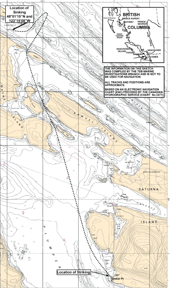
On the morning of 23 July 2009, the passenger vessel Explorathor departed Steveston, British Columbia, with 34 persons on board for a whale-watching excursion. At 1252, on the return journey, the vessel struck a submerged object off Croker Point, Saturna Island, British Columbia, and began to take on water. Passengers and crew were transferred to another whale-watching vessel. The Explorathor subsequently flooded and sank in Campbell Bay, Mayne Island, British Columbia, at 1334.
Factual information
Particulars of the vessels
| Name of vessel | Explorathor |
|---|---|
| Official number | 818502 |
| Port of registry | Québec, Quebec |
| Flag | Canada |
| Type | Passenger |
| Gross tonnage | 20 |
| LengthFootnote 1 | 13.11 m |
| Draught | 0.69 m (fully loaded)Footnote 2 |
| Built | 1996, Recherches et travaux maritimes R.T.M. Inc., Petite-Rivière-Saint-François, Quebec |
| Propulsion | Two D9-500 Volvo diesel engines driving two 600 BHP jet drives |
| Speed | 34 knots (max.) |
| Passengers | 32 (48 max.) |
| Crew | 2 |
| Registered owner | Vancouver Whale Watch Limited, Canada |
Description of the vessel
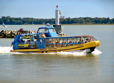
The Explorathor was a rigid-collarFootnote 3 passenger vessel capable of high speeds. Passengers were accommodated in enclosed seating forward and on a covered deck aft. The raised conning station was centrally located, and the propulsion machinery was located aft.
The aluminum hull was subdivided into four watertight compartments and a single compartment watertight collar. The vessel's intact stability report indicated that it could remain afloat with any one of these compartments flooded.
The conning station was equipped with communications and navigation equipment, including radar, very high frequence (VHF) radiotelephone, depth sounder, magnetic compass, global positioning system (GPS), electronic chart system, and automatic identification system.
History of the voyage
On 23 July 2009 at 0910,Footnote 4 the Explorathor departed Steveston, British Columbia, initially bound for the Gulf Islands, Footnote 5 British Columbia, with 32 passengers and two crew for a whale-watching excursion. The vessel's complement included the master and a crew member who was also working as a naturalist and tour guide. At 1205, the vessel began the return journey to Steveston via Plumper Sound to the Strait of Georgia, British Columbia. Travelling at approximately 28 knots, and with the navigational equipment in operation, the master used visual observation for the most part to navigate the passage. At approximately 1252, as the Explorathor was passing in close proximity to Croker Point on Saturna Island, Footnote 6 British Columbia, the vessel struck something and there was a scraping noise. Some on board hit their knees on the seats in front of them or almost lost their footing. Subsequently, passengers were reassured by the crew.
Following the striking, the master reduced speed before leaving the conning position unattended to check the aft compartment. After partially lifting the watertight cover, he observed a small amount of water, but no more than he had seen on any previous occasion. Returning to the conning station, he brought the speed back up, and continued his planned passage through Georgeson Passage to the Strait of Georgia.
At approximately 1258, the master saw that the aft bilge pump light was on and, as he altered to starboard to pass between Campbell Point and Georgeson Island, British Columbia, he felt the vessel respond sluggishly. After transiting the passage, he slowed the vessel and, at approximately 1301, communications were established on VHF channel 79A with the Explorathor Express,Footnote 7 which was approximately 0.5 nautical miles away. The master of the Explorathor requested that the Explorathor Express come alongside so as to transfer the passengers.
At approximately 1305, the Explorathor Express (with 30 passengers and 2 crew already aboard) came alongside. With the vessels alongside starboard to starboard, the passengers were transferred to the Explorathor Express. The master of the Explorathor counted the passengers as they transferred off the vessel. He also verified that no passengers remained on board. Passenger lifejackets were not distributed and remained stowed on board the Explorathor. Aportable gasoline engine-driven pump and hoses aboard the Explorathor Express were then transferred to the Explorathor to supplement the pump set already on board. By this time, the master of the Explorathor noticed that the starboard engine had stalled, and he heard the high-level bilge alarm in the aft compartment.
Unable to restart the starboard engine, the master of the Explorathor instructed the crew member to steer for shore and into Campbell Bay while he attempted to start the two portable pumps. Despite repeated attempts, this proved unsuccessful. The Explorathor was followed in close proximity by the Explorathor Express.
At 1327, the master of the Explorathor Express made a distress call on VHF channel 16 to Marine Communications and Traffic Services (MCTS) Victoria, British Columbia, to report that the Explorathor was sinking.
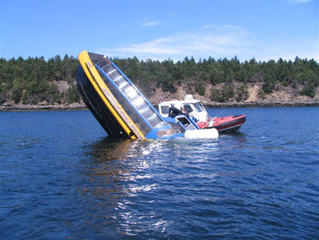
At approximately 1330, the Explorathor experienced a power failure and lost propulsion. The crew member donned a lifejacket and was transferred to a nearby private vessel, the Vertigo, followed by the master of the Explorathor. At 1344, the Explorathor sank in Campbell Bay in position 48°51'15'′ N, 123°15'08" W, after having floated for at least 5 minutes in a vertical position. The vessel's 50-person inflatable liferaft floated free from the vessel and inflated.
Transport Canada estimated that 22 litres of pollutant was released from the submerged vessel. The Explorathor was recovered two days later, towed back to Steveston, and subsequently scrapped.
Search and rescue
Upon notification of the distress call, JRCC (Joint Rescue Coordination Centre) Victoria tasked four vessels: the Coast Guard Auxiliary vessel Nu-Tu-Yu II, Canadian Coast Guard (CCG) lifeboat Cape Calvert, CCG fast rescue craft (FRC) Ganges 1, and the RCMP patrol vessel Driscoll.
As a safety precaution, the owner of the Explorathor chartered an additional whale-watching vessel, Crazy Legs, to carry a portion of the passengersFootnote 8 from the Explorathor Express back to Steveston. The Crazy Legs arrived on scene at 1450. The JRCC was advised at 1604 that both vessels had arrived in Steveston.
Croker Point
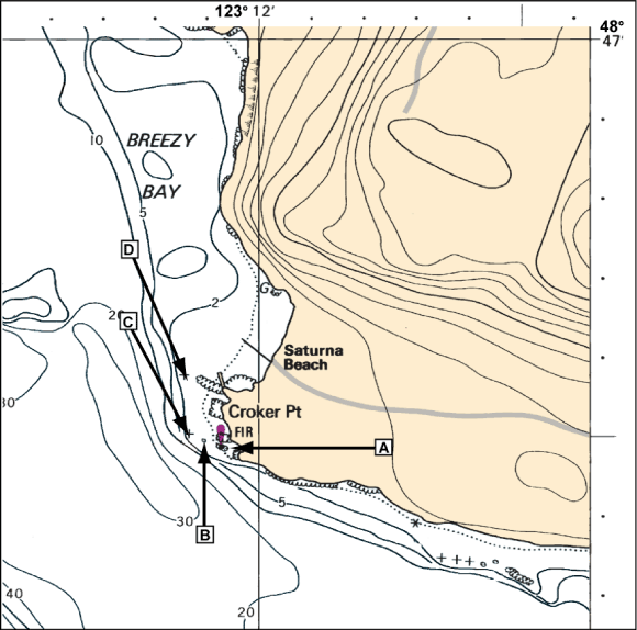
Canadian Hydrographic Service (CHS) Chart No. 3477 depicts several rocks off Croker Point (see Figure 1):
- A: an above-water rock with Croker Point light and daymark
- B: a drying rock, which would have been awash at low tide
- C, D: two underwater rocks with less than 2 m of depthFootnote 9
According to the Canadian Tide and Current Tables, rock B was approximately 0.14 m underwater at the time of occurrence.
Rocks B, C, and D are approximately 40 m and 55 m west, and 185 m northwest, respectively, of Croker Point light and daymark as measured from the chart.
Damage to the vessel
Post-occurrence inspection revealed damage to the keel and starboard side of the hull. The welded keel plates were separated for approximately 86 cm in way of the two after watertight compartments. A 7 cm hole was located to starboard of the keel at the watertight bulkhead between the two after compartments. There were also several deep scrapes and indentations along the water jet intake on the starboard side.
The port forward and starboard aft portions of the aluminum collar collapsed during the sinking.
Lifesaving equipment
Onboard lifesaving equipment included lifejackets for 50 adults and five children, two life buoys, and a 50-person inflatable liferaft.
Portable Pumps
Although not required by regulation, the Explorathor carried a portable gasoline engine-driven pump and hoses for firefighting or de-watering.
The portable pumps carried on board the Explorathor and the Explorathor Express were tested on 23 April 2009, ahead of the summer season. It was reported that the pumps had been used from time to time since, but no records had been kept. Although not designed for salt water use, it was reported that, when the pumps had been used with sea water, fresh water was pumped afterward to minimize corrosion.
Post-occurrence inspection of the two pumps revealed no physical damage, nor any obvious reasons for the pumps not starting.Footnote 10
Crew Certification and Experience
The master held a Master Limited for a Vessel of less than 60 Gross Tonnage certificate, a Restricted Engineer certificate,Footnote 11 and a Marine Emergency Duties (MED) A2 certificate. He had been employed by Vancouver Whale Watch Limited for the past 10 seasons, and had been navigating waters off the West Coast for 45 years.
The crew member, who had been employed by Vancouver Whale Watch Limited for the previous two seasons, held an MED A3 certificate.
Vessel Certification and Surveys
The Explorathor underwent a mandatory annual inspection by Transport Canada in May 2009 and carried an inspection certificate valid until 19 May 2010. The vessel was certified by Transport Canada to carry 48 passengers and two crew members.
Weather and Tide
Weather at the time of the occurrence was clear, with calm seas. Temperature was 21°C.
The height of tide for Croker Point at the time of the occurrence was calculated at 0.44 m above chart datum.
Whale-Watching Industry Practice
Whale-watching excursions are popular during the summer. Some operators offer tours twice daily, using vessels capable of high speeds to get to and from the viewing locations. As part of the experience, it is not unusual for such vessels to pass close to land at high speeds while en route to the viewing locations.
The company's vessels routinely travelled routes in close proximity to Croker Point at high speeds.
Whale-watching companies along the West Coast have formed the Pacific Whale Watch Association (PWWA),Footnote 12 which developed guidelines for local whale and wildlife viewing. These guidelines primarily address human/wildlife interaction, and include no-go areas for boats, noise and speed limits, and sonar restrictions. The owner of the Explorathor is a member of PWWA.
To provide employees with information regarding safety, policies, and operating procedures, the company created a handbook that included the PWWA's guidelines. These state in part: "A vessel's speed shall never exceed 30 knots when it is within [800 m] of any shoreline or known wildlife viewing areas (Hein Bank, Middle Bank, Constance Bank, etc.) at any time during a tour."Footnote 13
Risk-Based Safety Management
The International Code of Safety for High-Speed Craft, 2000,Footnote 14 (HSC Code) is a safety code for vessels capable of high speeds and that carry more than 12 passengers on international voyages. The safety philosophy of the HSC Code is based on the management and reduction of risk, as well as the traditional philosophy of passive protection in the event of an accident.Footnote 15 The HSC Code sets out a variety of parameters including vessel construction, safety, operation, and training.
The Explorathor was capable of speeds up to 34 knots and could carry up to 48 passengers. However, because the vessel operated domestically, the HSC Code did not apply.
The Explorathor did not have a safety management system (SMS) nor, as a vessel engaged in domestic transportation, was one required by regulation.
Analysis
Bottom Contact
When the scraping noise was heard, the vessel was travelling at approximately 28 knots in close proximity to Croker Point. Nothing was seen floating astern. The impact compromised the Explorathor's watertight integrity in two compartments, causing flooding that exceeded the vessel's damage stability limits.
The damage to the vessel-deep scrapes and indentations along the hull, and the separation of the welded keel plates- is consistent with striking a hard, solid object (such as a rock) at high speed. Given the presence of the drying rock and the two underwater rocks off Croker Point, as well as the height of the tide at the time of the occurrence, it is likely that the vessel struck one of these rocks.
Navigation Practices
When navigating in close proximity to shore and/or navigation hazards, best practices dictate that bridge personnel, while taking into consideration the prevailing circumstances and conditions, should demonstrate increased vigilance and heightened awareness. This includes:
- making use of all navigational aids, such as radar or other electronic position-indicating equipment;
- taking into account the proximity of navigational hazards, which may make it necessary to carry out additional navigation duties;
- maintaining a safe speed;
- maintaining a proper lookout; and
- never leaving the wheelhouse or steering position unattended.
These practices are particularly important for vessels operating at high speeds because less time is available to assess and respond to developing situations.
In this occurrence, the master was familiar with the route and generally aware of the rocks off Croker Point. He did not reduce speed while transiting the area—as this added to the "experience" for passengers—nor did he make full use of the navigational equipment to supplement his habitual reliance on visual references. At the time of the occurrence, however, the tide obscured the drying rock, depriving him of one potential visual cue. Because he did not have any other sources of position information, he was thus unaware of the vessel's exact position in relation to the rocks.
Distress Communications
It is important that vessels experiencing difficulty indicate this as soon as possible, so as to ensure timely assistance should it prove necessary.
In this occurrence, within 10 minutes of the striking, the master of the Explorathor recognized that the vessel was responding sluggishly. At that point, he communicated with the master of the Explorathor Express and arrangements were made to transfer the passengers. However, it was not for another 26 minutes—by which point it was clear that the Explorathor was sinking—that MCTS Victoria was notified, by the Explorathor Express.
Although the delay in indicating the vessel's distress was not a factor in this occurrence, failure to declare distress in a timely manner delays the response from Search and Rescue or any nearby vessels, thereby placing vessels, passengers, and crew at unnecessary risk.
Vessel Evacuation
During emergency situations, it is prudent to take emergency precautions, regardless of the apparent danger, as early as possible so as to avoid having to carry them out later under rushed, unsafe, or other less-than-optimal conditions.
In this occurrence, the master's assessment of the danger was such that a transfer was deemed necessary, although no drastic outcome, such as a sinking, was initially expected. However, he did not require the passengers to don lifejackets.
Although, in this occurrence, the other vessel arrived in time to offload the Explorathor, passengers may be at risk if precautions are not taken early enough during a developing emergency.
Maintenance and Testing of Emergency Equipment
During an emergency, it is vital that all equipment perform as intended. To help ensure this, equipment should be properly maintained and tested regularly, and crew members kept familiarized with its use.
In this occurrence, neither the pump on board the Explorathor nor the pump that was transferred from the Explorathor Express could be started, despite numerous attempts by the master of the Explorathor. Although a post-occurrence inspection revealed no physical damage to the pumps, and although both pumps had been tested less than three months previously, there was no evidence of a regular maintenance/testing regime. Records were not kept of how often the pumps were used, nor of how familiar the crew members were with their use. It could therefore not be determined why the pumps did not start.
In the absence of regular maintenance, testing, and crew familiarization, emergency equipment may not function as required when needed.
Managing Risks on Passenger Vessels Capable of High Speed
High-speed passenger vessels are different, in part, from conventional passenger vessels in that accidents have a greater potential to cause serious damage or injury due to their light construction and high speed. The key to managing the risks associated with their operation effectively is for operators to take into account the risks associated with the higher speed.
This occurrence, in which the master was, for the most part, navigating visually in close proximity to land while travelling at 28 knots and later had briefly left the wheelhouse unattended, highlights the need for operator guidance to manage these risks. Other than the PWWA's guidance for viewing whales and wildlife, with which the vessel was compliant, there is no industry guidance for the safe operation of passenger vessels capable of high speed.
Following a 2004 investigation into the striking of a wharf by a high-speed passenger catamaran, the TSB expressed concern that, in the absence of formal guidance to assist operators on the management and reduction of risks associated with passenger vessels capable of operating at higher speeds, safety deficiencies may not be adequately identified and addressed.Footnote 16
The unique issues associated with high-speed vessel operations have also been recognized by operators in the United States. In 1999, the Passenger Vessel Association—a not-for-profit organization representing nearly 500 vessel-operating and associate members of U.S.-flag passenger vessels of all types—established the first of two work groups, with the U.S. Coast Guard, to develop industry standards for the operation of high-speed vessels to which the 1994 HSC Code does not apply in U.S. domestic waters. This first work group developed guidelines in the areas of crew training, vessel operations, and navigational safety equipment.Footnote 17 The second work group developed guidelines for manning domestic non-Code high-speed vessels.Footnote 18
An effective safety management system allows operators to identify hazards associated with the operation, assess the risks arising from those hazards, and then identify possible mitigating strategies. There is no regulatory requirement for operators of Canadian passenger vessels trading domestically to have a safety management system.
In early 2009, Transport Canada initiated a two-year pilot project to test the functionality of a domestic safety management (DSM) system to improve, among other things, safety on board Canadian vessels. Transport Canada is in the final stages of developing a DSM manual and other tools that will help Canadian operators implement safety management. It is anticipated that these tools will be available to all operators in the near future as part of an information campaign that will seek to inform operators how the DSM system will improve safety protection in their operations.
Passenger vessels capable of high speeds are common in Canada. Given that these vessels continue to operate with no formal mechanism in place to identify and mitigate the associated risk, safety deficiencies may remain unidentified and unaddressed.
Findings
Findings as to causes and contributing factors
- The master of the Explorathor was navigating largely by visual means and did not make full use of available navigation equipment to track or verify the position of the vessel.
- Given the damage and the vessel's route, it is probable that the Explorathor made bottom contact with one of the submerged rocks off Croker Point, British Columbia.
- The bottom contact compromised the vessel's watertight integrity in two compartments, causing the vessel to flood beyond damage stability limits and eventually sink.
Findings as to risk
- In the absence of regular maintenance, testing, and crew familiarization, emergency equipment may not function as required when needed.
- Passengers may be at risk if lifejackets are not donned early in an emergency.
- Failure to declare distress in a timely manner delays the response from Search and Rescue or any nearby vessels, thereby placing vessels, passengers, and crew at risk.
- Vessels that operate at high speed, without appropriate consideration of the risks involved, may place themselves at risk.
Safety Action
Action taken
Following this occurrence, the owner, Vancouver Whale Watch Limited, retrained its crews on the safety equipment, including the use of the primary and auxiliary pumps. Crew members are now required to record each training and drill session in a log kept in the company office. Pre-trip planning has been expanded to include a discussion among the vessel masters and the owner on the weather, tides, courses, and navigational hazards. An updated version of the company safety manual has also been drafted.
This report concludes the Transportation Safety Board's investigation into this occurrence. Consequently, the Board authorized the release of this report on .


