Grounding
Tanker Nanny
Chesterfield Narrows, Nunavut
The Transportation Safety Board of Canada (TSB) investigated this occurrence for the purpose of advancing transportation safety. It is not the function of the Board to assign fault or determine civil or criminal liability. This report is not created for use in the context of legal, disciplinary or other proceedings. See Ownership and use of content. Masculine pronouns and position titles may be used to signify all genders to comply with the Canadian Transportation Accident Investigation and Safety Board Act (S.C. 1989, c. 3).
Summary
On 25 October 2012, the tanker Nanny ran aground on a shoal while outbound from Baker Lake, Nunavut, damaging the forward section of the hull. On 27 October, the vessel came off the shoal during strong northwesterly winds and later proceeded to St. John’s, Newfoundland and Labrador, for repairs. There were no injuries or pollution reported.
Factual information
Particulars of the vessel
| Name of Vessel | Nanny |
|---|---|
| Official number | 833250 |
| Port of registry | St. John’s, Newfoundland and Labrador |
| Flag | Canada |
| Type | Oil and chemical tanker |
| Gross tonnage | 6544 |
| Registered length Footnote 1 | 110.6 m |
| Draught | Forward: 4.6 m Aft: 4.6 m |
| Built | 1993, Ulsan, South Korea |
| Propulsion | 1 diesel engine (4050 kilowatts) driving a controllable-pitch propeller |
| Cargo | Diesel fuel (2893 m³) |
| Crew | 14 |
| Registered owner | Coastal Shipping Limited, Goose Bay, Newfoundland and Labrador |
| Manager | Coastal Shipping Limited |
Description of the vessel
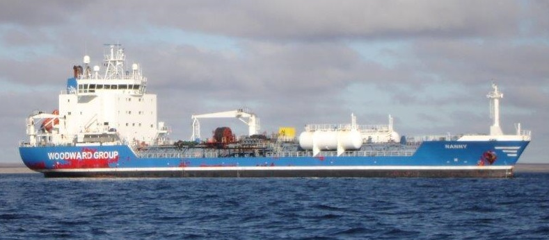
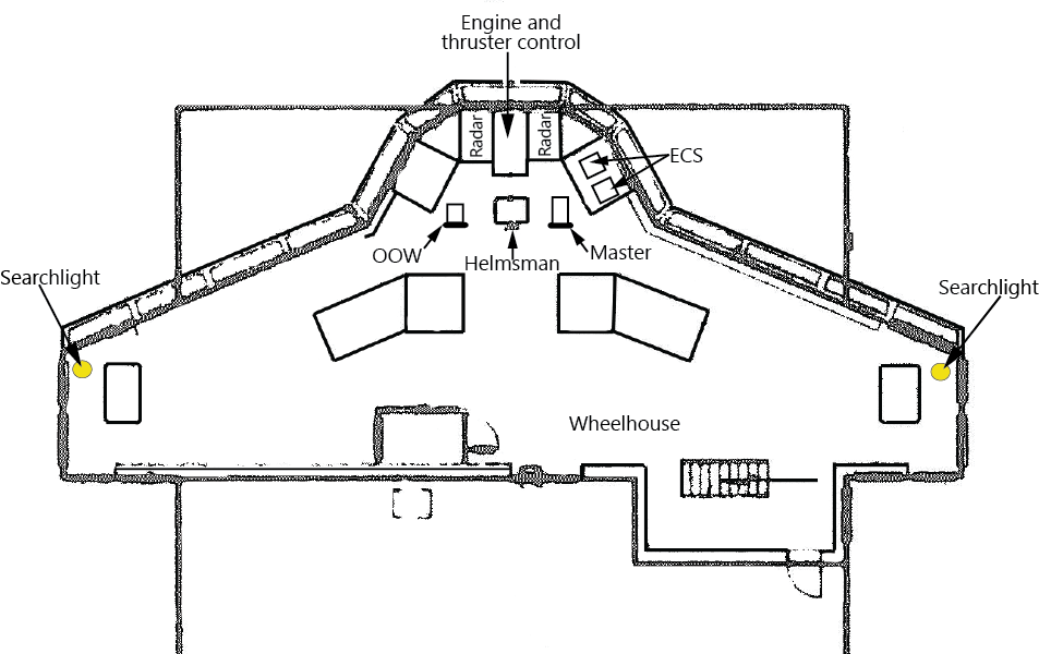
The Nanny is of typical oil tanker construction, with segregated ballast tanks and an aft superstructure on an ice-strengthened hull (Photo 1). Propulsion is provided by a diesel engine with a constant speed of 500 revolutions per minute (rpm). The vessel has a controllable-pitch propeller, a spade rudder, and 2 controllable-pitch tunnel thrusters of 450 kilowatts (kW) each, 1 at the bow and 1 at the stern. Port, centre, and starboard bridge consoles provide improved vessel handling during manoeuvres.
The bridge is equipped with the required navigational equipment, including 2 radars located on either side of the centreline. In addition, the vessel is fitted with 2 electronic chart systems (ECS), which are both located to the right and slightly aft of the starboard radar. The vessel has 2 global positioning systems (GPS), 1 located on the port side of the centre console, and the other located at the chart table on the port and after part of the bridge.
The vessel is also fitted with 2 manually-operated xenon searchlights. The control handles for the lights are located near the forward bulkhead of the bridge, and the handles extend below the deckhead on the port and starboard sides.
Baker lake fuelling operations
The Nanny is 1 of 2 shuttle tankers used to transfer fuel to Baker Lake, Nunavut, (Appendix A) from a larger tanker anchored about 20 nautical miles (nm) east of Chesterfield Narrows, near Helicopter Island, Nunavut. The Nanny and the second shuttle tanker, the Dorsch, are operated by Coastal Shipping Limited and each make about 15 fuel delivery transits per year. The fuel deliveries commence in July and continue until the Baker Lake shore tanks are mostly full. The deliveries then resume towards the end of the season, in September and October, in order to top up the shore tanks before winter.
While most fuel deliveries are made during daylight, some passages are made during darkness, particularly at the end of the season, when there are fewer daylight hours. Because the transit through Chesterfield Narrows must take place during a 30 to 60-minute window, which occurs about every 12 hours at high water slack tide, the possibilities to pass through the narrows during daylight are limited.
Fuel deliveries to Baker Lake using tugs and barges have been ongoing for decades, yet Coastal Shipping Limited first began using tankers to transport fuel to Baker Lake in 2003. Canadian Coast Guard (CCG) records for the Baker Lake area indicate a significant increase in vessel traffic starting in 2006, from an average of 5 vessel transits per year to a peak of 36 in 2008. The increase in vessel traffic and fuel deliveries is a result of the construction and operation of the Meadowbank gold mine, which began production in 2010 and is located 86 km north of Baker Lake.
Chesterfield Narrows
In order for vessels to reach Baker Lake, they must transit through Chesterfield Narrows. This is a challenging passage with a minimum clearing distance of 0.04 nm from certain hazards when a vessel is on the range beacons (at high tide, with a draught of 4.6 m). The Sailing Directions for Hudson Strait, Hudson Bay and Adjoining Waters indicate that Chesterfield Narrows, and the area east of it, is suitable only for daytime navigation in good visibility due to strong currents. The tidal currents flow westward for the 3 to 4 hours of flood tide and can reach rates of up to 4 knots. Slack water occurs 30 minutes before and after the flood tide. The eastward ebb flow lasts 8 hours and, at low water, can reach maximum rates of up to 8 knots. Footnote 2
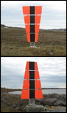
To assist vessels transiting through the narrows, the CCG established 2 pairs of unlit range beacons, known as day beacons (Photo 2). The paired day beacons are separated from one another in both distance and elevation. When a vessel approaches the paired beacons in such a way that they align, with 1 appearing above the other, a course to follow for a safe passage through the restricted waters is provided.
Since 2007, there have been 4 instances where CCG was notified of vessel groundings in Baker Lake and Chesterfield Inlet. Two of these groundings, including the present occurrence, occurred in Chesterfield Narrows.
Navigational practices of shuttle tankers in Chesterfield Narrows
To reduce the risk of grounding when navigating through the narrows, the 2 shuttle tankers adhered to the following practices: Footnote 3
- ensure a maximum draught of 4.6 m;
- execute the passage at high tide and slack water;
- position the vessel as close as possible to the charted route indicated in the passage plan; and
- maintain a distance of at least 0.1 nm off Ice Breaker Islet (Appendix A).
In addition, the vessel’s speed was usually reduced to 3.5 or 4 knots to limit any effects of squat and heel that could increase the maximum draught, while still allowing for adequate control of the vessel’s movements. During passages after dark, the searchlight was normally operated by the officer of the watch (OOW) to visually sight the range beacons and confirm that the vessel was on course.
History of the voyage
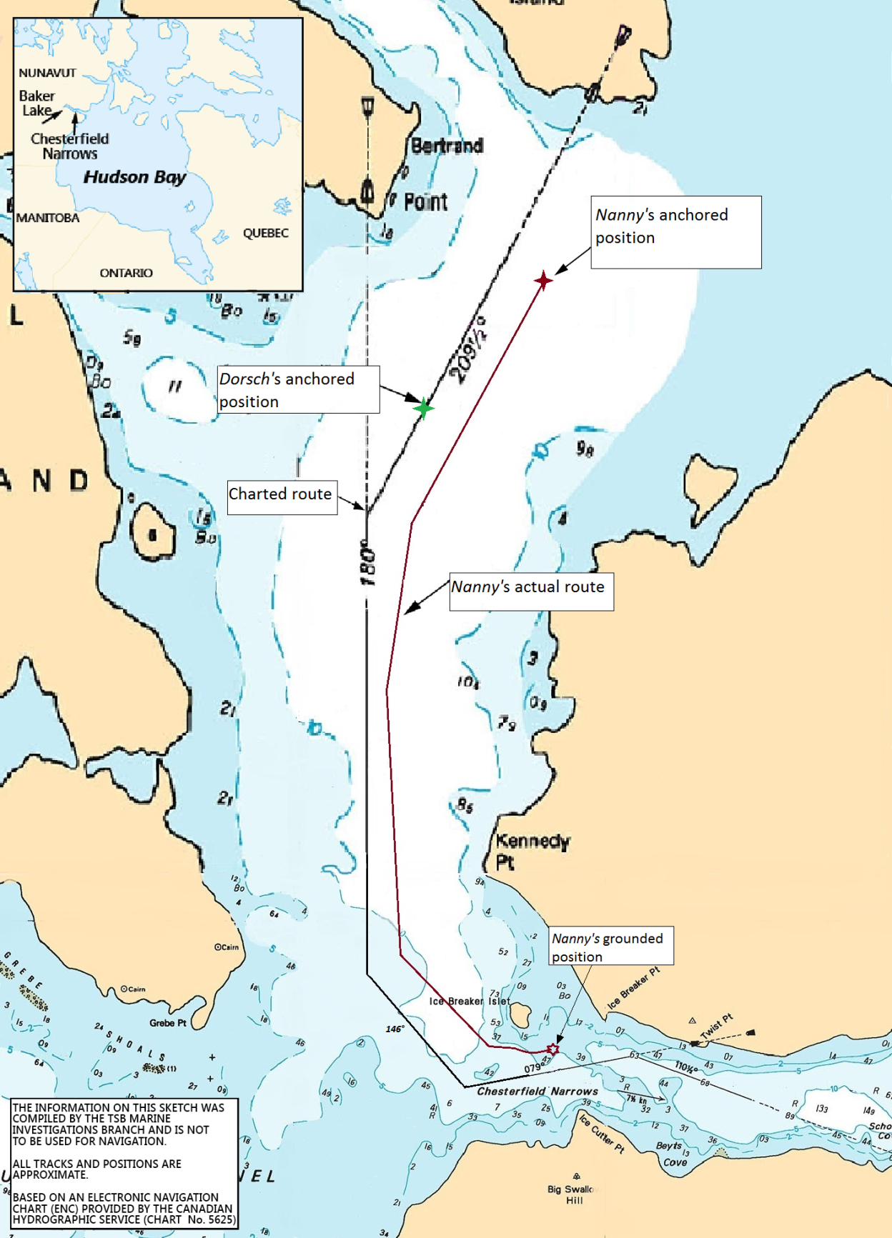
At 1300 Footnote 4 on 25 October 2012, the Nanny departed Baker Lake for Lewisporte, Newfoundland and Labrador, following scheduled fuel delivery operations. At 1600, the vessel anchored 1.8 nm north of Ice Breaker Islet to await high tide in Chesterfield Narrows south of the islet (Figure 1). The Dorsch was already anchored along the charted route, 0.5 nm southwest of the Nanny. It was decided that the Nanny would pass the Dorsch and proceed ahead in order to arrive at Chesterfield Inlet during high tide.
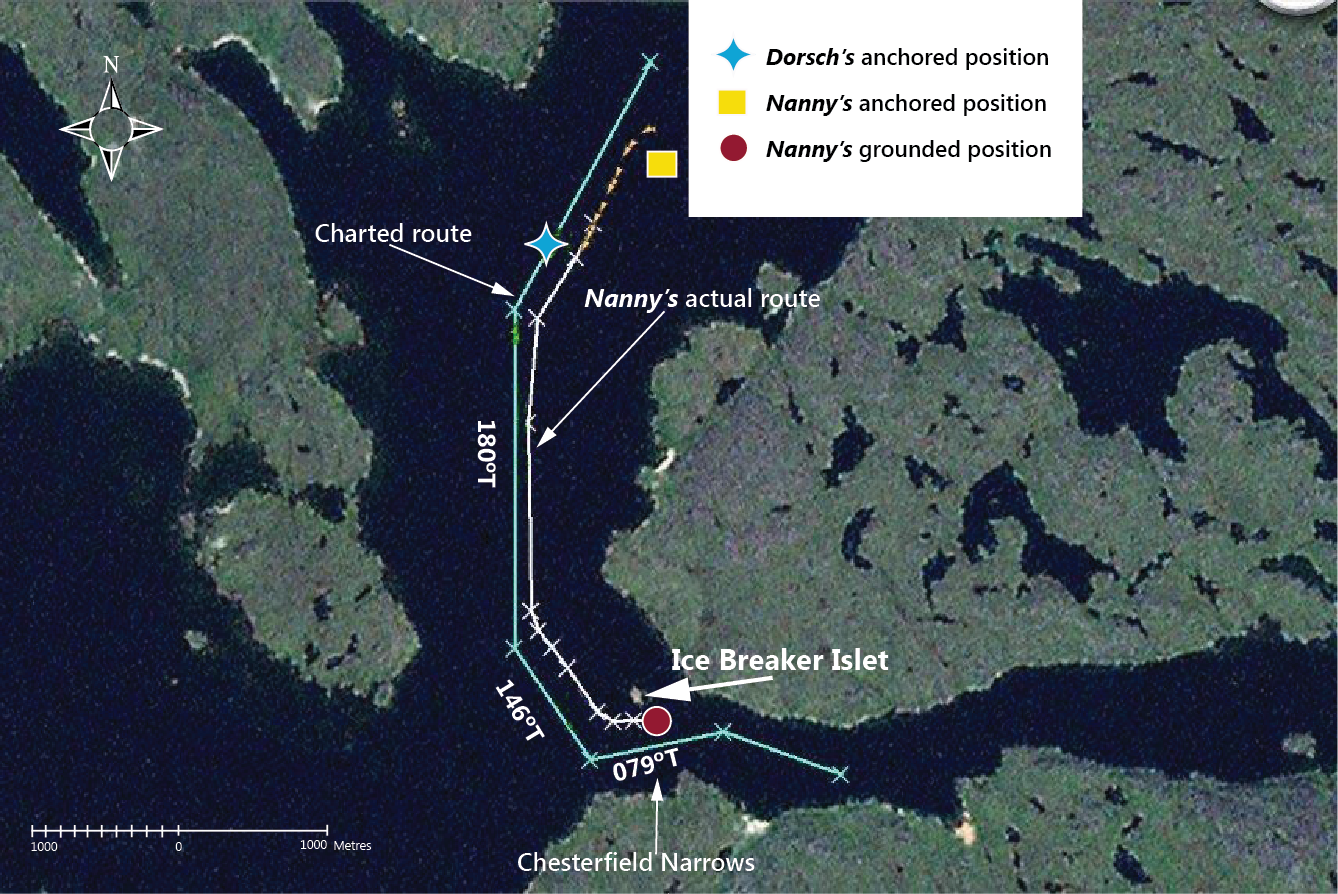
At around 2200, the OOW on the Nanny went forward and weighed anchor. With the master at the con, the vessel then proceeded south of the charted route in order to pass the Dorsch. The master was positioned at the starboard radar and was using distances off various landmarks on the starboard radar to pilot the vessel, while the helmsman was steering manually. The port searchlight had frozen in place a few days prior, but was illuminating forward. It was to be used to visually confirm that the vessel was on the Twist Point range beacons for the 079ºT course once the vessel reached that portion of the passage (Appendix A). The starboard searchlight, which was pointing aft, had been found to be frozen in place earlier that day.
By approximately 2227, the Nanny was 0.1 nm southeast of the charted route and was passing the Dorsch. At this time, the OOW had rejoined the master on the bridge. Approximately 2 minutes later, the master altered course towards 180°T. The vessel then proceeded parallel to the charted course line, but off it by about 0.05 nm (Figure 1). Shortly afterwards, the OOW plotted the vessel’s position on the chart and then sat in the chair by the port radar. Over the next 15 minutes, no other positions were plotted or noted on the chart, and the Nanny continued to proceed off the charted course line, but roughly parallel to it.
Shortly before 2238, the master altered course towards 146ºT. The vessel’s speed then decreased from 7.9 to 5.6 knots, and the Nanny continued parallel to the 146°T charted course line, but off it by up to 0.12 nm.
At around 2242, the master ordered the helmsman to make an alteration to port to bring the vessel onto the 079°T course line towards Chesterfield Narrows. The master then reduced the vessel’s main propeller pitch and, as the vessel was altering to port, its speed decreased to 3.6 knots. Soon after, the helmsman informed the master that the heading was approaching the requested heading of 079°T and advised that the rudder was hard to starboard, but the heading was still altering to port.
At 2244, the vessel was approximately 0.09 nm north of the 079°T charted course line on a heading of 082°T. The master increased the main propeller pitch ahead, while also using the thrusters to steady up on the 079°T heading, as was sometimes required when the helmsman was having difficulty checking the port turn at this location. About 1 minute later, the vessel’s speed had increased to 5.1 knots, and the heading had swung back to starboard and was now 098.7°T.
The master then manoeuvred the vessel’s heading back to port, towards 079°T, at which point the bridge team became aware that the Twist Point range beacons had not been sighted. A shudder was felt on the vessel. The OOW checked the radar and advised the master that the vessel was close to Ice Breaker Islet. The radar was indicating 0.07 nm to the islet, less than the required distance of 0.1 nm. At this time, the vessel was on a heading of 076.2°T and travelling at a speed of 4.5 knots. The master then manoeuvred the vessel’s heading to starboard, towards 079°T. By 2247, the vessel was aground on a heading of 079.4°T in position 63°59.6′ N, 094°18.4′ W, about 0.05 nm north of the charted course line for the Twist Point range beacons (Appendix A).
Events following the grounding
Immediately after the grounding, the master reversed the main propulsion in an attempt to refloat the vessel, but this attempt was unsuccessful. Further attempts to refloat were made using the thrusters, the main propulsion, and the rudder. At 2255, the main breaker for the bow thruster tripped and could not be restarted. Shortly after, the fire alarm for the bow thruster room sounded due to heavy smoke from the failed bow thruster motor.
The crew carried out emergency procedures, including sounding the tanks and manually sounding the depths around the vessel. Around 0100, the starboard anchor was let go with about a half-shackle of chain in the water, and efforts to free the vessel ended.
At 0300, the vessel’s shore manager was contacted; the shore manager then called the Alsterstern Footnote 5 and requested it provide assistance to the Nanny as required. The Alsterstern turned back and eventually anchored off Ellis Island at the mouth of Chesterfield Inlet. At 0437, almost 6 hours after the grounding, NORDREG Footnote 6 was advised that the Nanny was aground, that numerous unsuccessful attempts had been undertaken to refloat the vessel, and that another attempt was planned during the next high tide, when the vessel was expected to refloat. About 1 hour later, NORDREG advised Transport Canada Marine Safety and Security (TC) that the Nanny had grounded. TC then established communications via email with the Nanny, the vessel’s shore manager, Det Norske Veritas (DNV), and NORDREG.
During the next high tide, at around noon on 26 October, the Dorsch attempted to pull the Nanny off the shoal, but the line parted. No further attempts to free the Nanny using the Dorsch were made. Just before the next high tide around midnight, the stern thruster and main engine were used in further attempts to free the vessel, but it remained aground.
At 0705 on 27 October, the vessel’s stern was pushed to starboard by northwesterly winds of 35 knots, causing the vessel to come off the shoal. The master then conned the vessel back out of the narrows and anchored north of Ice Breaker Islet, where the crew surveyed the damage on board. That evening, the Nanny advised the designated person ashore (DPA)/fleet manager and the shore manager that the vessel’s stability in damaged condition had been calculated. All values were above the International Maritime Organization (IMO) minimum requirements, indicating the vessel could safely return to St. John’s.
The DPA forwarded an email to DNV that summarized the grounding and damage, the master’s assessment of the stability conditions, and the master’s assessment of the damage. The email also included pictures of the damage and requested that DNV provide a damage assessment and clearance for the voyage to St. John’s. By the afternoon of 27 October, DNV had completed a damaged condition stability assessment. It issued a condition of class on 28 October (due on 06 November 2012), which allowed the Nanny to sail to the nearest drydock and repair facility (St. John’s). DNV forwarded the condition of class, along with damage assessment and stability information, to TC, who advised NORDREG that a condition of class had been issued and that the vessel could now be granted clearance. After transferring its cargo of diesel fuel to the Alsterstern, the Nanny departed for St. John’s.
Damage to the vessel
The hull bottom plating in the bow thruster compartment and the machinery space were indented, as was the forepeak water ballast tank. Port and starboard water ballast tanks No. 1 through 5 and starboard water ballast tank No. 6 were also indented.
Some of these compartments were set up as much as 150 mm in places, with many tripped stiffeners and brackets. The port and starboard bilge keels were set up along their entire length. Ballast tank No. 2C was holed when the vessel came off the shoal during strong winds on 27 October (Photo 3).

The bow thruster propeller was also damaged; it was bent, and the crown and pinion gears were stripped. The driving-shaft seal and electric motor were set up approximately 60 mm, and the free-end cover was shattered into 4 pieces.
Further inspections undertaken after the vessel arrived in St. John's in early November found that the bow thruster propeller blades had sustained extensive mechanical damage, most likely caused by rocks being sucked through the thruster tunnel after the grounding and jamming the blades (Photo 4). The main propeller and stern thruster propellers were also found to have sustained some mechanical damage.

Vessel certification
The vessel was crewed and equipped in accordance with existing regulations. It held valid certificates issued by DNV as delegated by TC.
Personnel certification and experience
The master and navigating officer held the required certificates of competency for their respective positions. As part of the requirement for their certification, the master and the Nanny's navigating officers had received simulated electronic navigation training.
The master held a Master, Near Coastal certificate of competency and had 20 years of experience on coastal vessels, serving 5 years as master and 7 years as OOW. Prior to the occurrence, the master had served as relief master on the Nanny and the Dorsch for approximately 3 years. During the spring of 2012, the master served as master of the Dorsch while it was on the Baker Lake shuttle run, and in September 2012, joined the Nanny as master for the fall Baker Lake shuttle run. The master had made about 30 transits through Chesterfield Narrows, with about half of them taking place at night.
The OOW held a Chief Mate, Near Coastal certificate of competency and had approximately 20 years of experience. He had first sailed as OOW in 1997 and initially joined the Nanny in August 2012 as third mate. Prior to the grounding, he had made a few transits through Chesterfield Narrows; this was his second passage at night.
Environmental conditions
High water at Norton Island Footnote 7 was calculated to occur at 2038 on 25 October and at 0912 on 26 October. Slack water at Chesterfield Narrows occurs 2 to 2.5 hours after high water at Norton Island. On 25 October, there were more than 15 hours of darkness, with sunset at 2100, and nautical twilight at 2248. On 26 October, nautical twilight occurred at 1031, and sunrise occurred at 1219.
At the time of the occurrence, the wind was from the northwest at 15 knots. The skies were overcast, with good visibility. There was no sea ice present in the area.
Voyage planning and monitoring
According to the IMO, Footnote 8 all vessels should complete a voyage plan in order to ensure the safe passage of the vessel from berth to berth. Voyage planning consists of 4 stages:
- Appraising all available information about the intended voyage, including reviewing the relevant charts and publications; predicting the vessel's condition; assessing the expected dangers; gathering information about environmental and local weather conditions; and determining how to obtain weather forecasts and local warnings en route.
- Planning the intended voyage, and identifying no-go areas and areas where special precautions must be taken.
- Executing the voyage plan while taking into account the prevailing conditions.
- Continuously monitoring the vessel's progress against the intended plan throughout the voyage and gathering the pertinent local warnings.
As per company policy, the Nanny carried a shipboard operations manual (SOM), which includes a section on passage planning. Footnote 9 This section indicates that, before passage planning can commence, an appraisal is to be completed. This appraisal includes gathering and studying charts, publications, and other information appropriate for the voyage.
The SOM on board the Nanny states that the passage plan should incorporate maximum allowable off-track margins for each leg, as well as wheel-over positions and turn radiuses for each course alteration, where appropriate. The SOM also states that, at any time during the voyage, a vessel may need to leave the planned route temporarily on short notice. Furthermore, it states that marking relatively shallow waters and minimum clearing distances in critical sea areas on the chart is but one technique to assist the OOW in deciding to what extent the vessel can deviate from the charted course without jeopardizing safety and the marine environment.
For passages planned through coastal or restricted waters, the SOM stipulates that due consideration must be given to ensure effective monitoring of the vessel's progress and that, at all times, 2 or more means of position fixing must be maintained. The vessel's position is to be monitored while approaching the wheel-over position at the end of a course, and then again after the alteration to check that the vessel is safely on the new course. The SOM further specifies that, when the vessel is in confined or restricted waters, the ECS should be used to its full extent to check the vessel's position and track in relation to its intended track.
Standard passage plans for the Baker Lake to Helicopter Island route had been in use on board the Nanny since 2010. These standard plans included, among other things, 35 waypoints and courses that incorporated all the range beacons indicated on the charts. Limitations relating to a draught of 4.6 m, a mast-to-keel height of 34 m, and an air draught of 29.4 m were specified. The execution notes included with the passage plans specified that parallel index lines with clearing distances were to be marked on the charts.
At the time of the occurrence, a standard passage plan from Baker Lake to Helicopter Island was on the bridge. It did not provide any additional instructions or modifications, nor did it include wheel-over positions or turn radiuses for each course alteration. The chart was not marked with maximum allowable off-track margins for each leg, shallow waters, minimum clearing distances in critical sea areas, or parallel index lines with clearing distances.
Some of the standard navigational practices used by both shuttle tankers in Chesterfield Narrows were not specified in the passage plan, such as completing the passage at high tide and slack water, positioning the vessel as close as possible to the charted route indicated in the passage plan, maintaining a minimum distance of 0.1 nm off Ice Breaker Islet, and using the searchlights to sight the range beacons during passages in darkness.
Bridge resource management
Bridge resource management (BRM) is the effective management and use of all resources, human and technical, available to the bridge team to ensure the safe completion of the voyage. BRM incorporates concepts of workload management, problem solving, decision making, teamwork, and situational awareness. In addition to performing their regular duties, bridge team members have a responsibility to maintain overall situational awareness Footnote 10 and exchange information with one another. Footnote 11 This is especially important during higher-risk operations. Exchanging information helps to ensure that a crew shares a common understanding of a situation. Furthermore, situational awareness is enhanced when team members monitor one another's performance and provide feedback to each other. Footnote 12
In this occurrence, prior to weighing anchor, the master and OOW did not review the passage plan, even though it required a change to allow the Nanny to pass by the Dorsch. Once the vessel was underway, there was little communication between the bridge officers until the grounding.
Regulatory requirements for Bridge Resource Management Training
Currently, TC does not require bridge officers to complete BRM training to achieve or maintain their certificates of competency, although it does set standards for non-mandatory BRM training. Footnote 13 TC is planning to amend the Marine Personnel Regulations (MPR) in accordance with the 2010 Manila Amendments to the Convention on Standards of Training, Certification and Watchkeeping of Seafarers (STCW). The planned TC amendments to the MPR would make BRM competencies and knowledge a requirement to obtain a Watchkeeping Mate certificate of competency. Secondly, the TC-approved STCW bridge resource management training course would be mandatory to obtain the following certificates of competency:
- Master Mariner
- Master, Near Coastal
- Master 3000 Gross Tonnage, Unlimited
- Master 3000 Gross Tonnage, Near Coastal
- Chief Mate
- Chief Mate, Near Coastal
In this occurrence, the master had completed a formal thirty-hour BRM course Footnote 14 in April 2012. The OOW had not completed BRM training.
Ship's navigational equipment
The full use of all available navigational equipment is part of BRM and ensures the safe passage of a vessel while enabling cross-checks in case of equipment or operator error. The Nanny had 2 radars that could be used for parallel indexing or to determine the vessel's position off landmarks by ranges and bearings. The starboard radar had a route overlay feature which, when enabled, indicated both the current waypoint, Footnote 15 as well as the bearing and distance to it from the vessel's present position.
The vessel also had 2 GPSs on board, 1 of which was supplying inputs to both ECSs and both radars. In addition to having cross-track error (XTE) features, track plotters, and waypoint alarms, Footnote 16 both GPSs continuously displayed the range, bearing, and estimated time of arrival at the next waypoint (if the vessel's route from the passage plan was activated). The GPSs could be used to manually plot the vessel's position on the chart.
The bridge of the Nanny was fitted with 2 ECSs, 1 original to the vessel and 1 installed in 2011. Both ECSs were capable of interfacing with other navigational equipment in order to electronically stream Footnote 17 real-time vessel data and display this data on the relevant electronic chart, if available. Footnote 18 They could also provide audible and visual alerts, such as XTE alarms, which would activate when the vessel exceeded set limits off the course line.
Prior to the occurrence, the radars were set up for parallel indexing, but the route overlay was not enabled. The XTE audible alarm feature on the GPSs was not activated, nor were the GPSs being used to manually plot the vessel's position on the chart. Both of the ECS monitors on the Nanny were displaying the charted route as indicated on the vessel's voyage plan. However, the XTE on the ECS original to the vessel was set to 0.1 nm for the passage through Chesterfield Inlet, and the audible alarm was turned off. The XTE features and available alarms on the ECS installed in 2011 were not in use, but the tracking feature had been activated and was plotting the vessel's course made good on the electronic chart.
Arrangement of navigational displays
The IMO and the International Organization for Standardization (ISO) have established guidelines for bridge design and standards for the arrangement of navigational systems. Footnote 19,Footnote 20 One guiding principle with regard to the arrangement of navigational systems is that it should enable the bridge team to have convenient and continuous access to essential information.
On the Nanny, the ECS monitors were not positioned in the immediate field of view of the officer at the starboard radar, nor were they in a centralized position to enable 2 bridge officers to make use of them (Figure 2). In contrast, on the Dorsch, the 2 ECS monitors were located close to the starboard radar and in line with it, putting them in the immediate view of the bridge officer at that station, and allowing for cross-checks between radar and ECS data.
Requests for aids to navigation
The CCG provides and maintains aids to navigation in Canadian waters to facilitate the safe and expeditious movement of maritime traffic. In 2010, with the increase in nighttime tanker traffic to meet the greater demand for fuel at Baker Lake, industry requested that lights be displayed on the 2 sets of range beacons in Chesterfield Narrows. The request was deemed to be a high priority at the April 2011 meeting of the Arctic Marine Advisory Board sub-committee on charting and aids to navigation. Footnote 21
Requests for new aids or modifications to aids require that a site assessment and a level of service (LOS) analysis be completed by the CCG in order to determine the project's feasibility. The CCG's LOS standards document identifies a number of factors to be considered, including the degree of risk present, whether the aids are justified by the traffic volume, and whether the aids are necessary for re-supply to isolated communities that are dependent upon marine transportation. The service standard for visual aids specifies that, where feasible, aids are to be visible at least 75% of the time during the worst month of the navigation season. Once the assessment and a LOS analysis have been completed and funds have been allocated, the project is realized. The CCG's LOS standards document Footnote 22 does not include timelines for the completion of projects. At the time of the grounding, neither a site assessment nor a LOS analysis had been performed for Chesterfield Narrows.
Voyage data recorder
Various modes of transportation use data from voice and data recorders to support investigations into accidents or incidents. In the marine industry, a voyage data recorder/simplified voyage data recorder (VDR/SVDR) is designed to record such parameters as date and time; vessel heading, position, and speed; very high frequency (VHF) radiotelephone communications; radar images; rudder, engine orders and responses; wind speed and direction measurements; and bridge audio.
It is important that the button to save VDR/SVDR data be pressed as soon as possible following an accident to ensure that the data relevant to the occurrence is preserved for use by investigators. As it is unlikely that investigators will arrive on scene early enough after an accident to initiate the saving of VDR/SVDR data, the owner must be responsible, through on-board standing orders, for ensuring the preservation of this data. Footnote 23
Although not required by regulation, the Nanny was equipped with an SVDR. To save the SVDR data relevant to the occurrence, the data button on the Nanny's SVDR activation panel had to be pressed within 12 hours of the grounding. The SVDR activation panel was located adjacent to the port radar on the bridge.
The button to save SVDR data was not pressed immediately following the grounding, and the data pertaining to the occurrence was overwritten. No one on board the Nanny and none of the company personnel made available onshore were aware of how to save SVDR data, nor were there on-board standing orders to specify the procedure for saving data. The button was initially reported to have been pressed about 2 hours after the 12-hour time period in which information relevant to the occurrence would have been recorded.
SVDR data downloaded on board the Nanny by Transportation Safety Board (TSB) investigators on 04 November 2012 indicated that an additional save of SVDR information, which occurred on 30 October, had effectively overwritten any prior saved data. The download also indicated that vessel heading was not being recorded. Furthermore, the radar screen shots and bridge audio recorded by the Nanny's SVDR were unusable.
Outstanding recommendations
In 1995, the TSB published a report entitled A Safety Study of the Operational Relationship between Ship Masters/Watchkeeping Officers and Marine Pilots. Footnote 24 The objective of this study was to identify safety deficiencies associated with teamwork on the bridge, including communication between marine pilots and masters/officers of the watch. The report raised safety concerns related to the implementation of effective BRM by bridge teams and made the following recommendations:
The Department of Transport require that the initial training syllabus for all ship officers be modified to include demonstration of skills in Bridge Resource Management.
Transportation Safety Recommendation M95-09
The Department of Transport require that all ship officers demonstrate skills in Bridge Resource Management before being issued Continued Proficiency Certificates.
Transportation Safety Recommendation M95-10
In January 1996, TC stated, in its response to these recommendations, that it would promote the development and provision of BRM training courses and that there would be a requirement for prior completion of such courses once available in Canada. TC further indicated that such a requirement would be phased in depending on the certificate of competency held by the candidate. The responses to both recommendations have been assessed as Satisfactory Intent by the Board. Footnote 25
Analysis
Events leading to the grounding
In this occurrence, the Nanny was initially required to proceed off the charted course in order to pass the Dorsch. However, this deviation was not discussed by the master and the officer of the watch (OOW), nor did they exchange other navigational information after the vessel weighed anchor. Once clear of the Dorsch, the Nanny continued on a roughly parallel course that was off the charted route by distances of up to 0.12 nautical miles (nm). This deviation from the charted route continued even as the vessel turned into Chesterfield Narrows, an area marked by range beacons, that allows for little margin of error and requires the vessel to remain as close as possible to the course line.
Prior to the grounding, after the vessel turned into the narrows, the master focused his attention on manoeuvring the main engine controls and thrusters, rather than monitoring the navigation of the vessel.
The radar was not cross-referenced by other means, nor was the navigational equipment set up to optimize the available information and facilitate the task of monitoring the vessel's position. The bridge team remained unaware that the vessel was well off the charted route. The searchlights were not used to visually confirm that the vessel was lined up with the range beacons. The bridge team's perception was that the vessel was being routinely navigated through the narrows, until it ran aground approximately 0.05 nm north of the charted route.
Use of navigational equipment
It is important that navigational equipment, such as radars, GPSs, and electronic charting systems (ECSs), be used to their full potential when planning, executing, and monitoring a voyage. This requires the bridge team to configure equipment correctly and enable features such as route overlay, cross-track limits (XTE), and associated audible alarms. The Transportation Safety Board of Canada (TSB) has previously found Footnote 26 that navigation equipment not set up to take full advantage of available safety features deprives crew of timely warnings. On the Nanny, it was standard practice to maintain a distance of at least 0.1 nm from Ice Breaker Islet. As such, the ECS XTE needed to be set to 0.02 nm to provide an alarm in the event the vessel came within 0.1 nm of the islet. However, the ECS in use on the Nanny was set to an XTE of 0.1 nm for the entire charted route, and the audible alarm was turned off. This precluded the issuance of a timely warning in a situation where a deviation greater than 0.02 nm was occurring.
In situations such as this one, where a vessel's progress is not being closely monitored by the crew, the importance of enabling navigational equipment features and audible alarms becomes even greater. If enabled, the audible alarms on the Nanny's ECSs and GPSs could have alerted the bridge team as to the vessel's position relative to the charted course and prompted them to monitor it more closely. However, because this navigational equipment was not optimally configured, the bridge team was not prompted to check the displays, which were indicating that the vessel's position was off the charted course as it entered Chesterfield Narrows, a critical point in the passage.
If navigational equipment and its associated features, such as alarms, are not optimally configured, potentially useful information to assist in the vessel's safe navigation may not be available to bridge teams.
Arrangement of navigational displays
The arrangement of navigational displays is an important factor in promoting effective bridge resource management (BRM) and facilitating the bridge team's task of navigating the vessel safely. Navigational displays are in an ideal location when they are within the bridge officers' immediate field of view, defined as “the viewing area with eye rotation only.” Footnote 27 When 2 bridge officers are required to make use of the same display, a good practice is to provide duplicate displays or to centre the displays between bridge personnel for ease of use.
On the Nanny, the ECS displays were not positioned in the immediate field of view of the officer at the starboard radar, nor were they in a centralized position to enable 2 bridge officers to make use of them.
Bridge Resource Management
Maintaining situational awareness through effective teamwork and communication between bridge team members is most important when a vessel is operating in restricted waters. In order to maintain overall situational awareness, it is critical that members of the bridge team know the master's intentions and provide timely advice or observations. This can be achieved with an initial briefing, followed by regular exchanges of information between members of the bridge team, including the master.
In this occurrence, a lack of BRM contributed to a situation where the bridge team was unaware that the vessel was well off the charted course as it entered Chesterfield Narrows. The following factors limited the bridge team's situational awareness and ability to recognize that the vessel was off the charted route:
- Prior to weighing anchor, the voyage plan was not reviewed to ensure that all bridge team members had a common understanding of the vessel's intended route, despite the fact that an initial deviation off the charted course was required and that the usual bridge team practices were altered as a result.
- The OOW was not actively involved in piloting the vessel; as such, the master was not sharing or comparing vessel positioning data with him.
- After leaving the anchorage, there was minimal, if any, communication between the bridge officers on the Nanny, limiting the opportunities to identify how far the vessel was off the charted route.
- Prior to and after weighing anchor, the master and OOW did not perform cross-checks to verify that the radar settings were correct (especially given the required course deviation); that both officers were using similar navigational practices (i.e. parallel index lines, distances off, or waypoints); and that the vessel's position was being accurately determined at all times.
Although the master had recently completed BRM training, this alone may not have been sufficient to ensure that BRM was being effectively implemented. In this occurrence, the principles taught in the BRM course attended by the master were not implemented, suggesting that training transfer Footnote 28 had not occurred. Effective training transfer can be accomplished by having employees perform certain activities to more effectively and quickly apply the skills they have learned during training. Linking training to performance management and development processes can also help foster accountability for follow-up and learning among trainees. Footnote 29,Footnote 30 Furthermore, providing training to more than 1 bridge officer may help ensure that the team implements BRM best practices.
As demonstrated in this occurrence and others, Footnote 31 shortcomings in the implementation of BRM principles have been a factor contributing to marine accidents. Although Transport Canada Marine Safety and Security (TC) has proposed amendments to the Marine Personnel Regulations, there is currently no regulatory requirement for bridge officers to complete training or demonstrate continued proficiency in BRM as a prerequisite to obtain or maintain certificates of competency.
The OOW on the Nanny did not have formal BRM training and was acting as third mate, a position that only requires a Watchkeeping Mate certificate of competency. However, during his watch, he was the only officer on the bridge assisting the master when the vessel was operating in restricted waters.
While BRM training provides a bridge officer with practical training and the confidence required to exchange information with the bridge team, including the master, the planned TC amendments will not require BRM training for a Watchkeeping Mate certificate of competency. Without formal training and continued proficiency in the principles of BRM for all bridge officers, there is an increased risk that bridge team awareness and effectiveness will be impaired, thereby increasing the risk to the vessel, its complement, and the environment.
Refloating attempts
Before attempting to refloat a grounded vessel, it is important that the vessel's seaworthiness (including damage stability, residual hull strength, and machinery condition) be assessed, and appropriate measures be taken to mitigate risks associated with refloating operations. The master is responsible for weighing the risks of remaining aground against the risks of taking prompt action to refloat the vessel.
The master of the Nanny decided to attempt refloating the vessel immediately after the grounding even though he did not have sufficient damage stability information to determine whether or not the vessel would be stable once off the shoal. The actual condition of the hull was unknown. Nevertheless, continued attempts were made to back the vessel off the shoal immediately following the grounding.
Without a complete and formal assessment of a vessel's seaworthiness prior to a refloating attempt, as well as readily-available search and rescue resources, there is a risk that such attempts may place a vessel, its crew, and the environment at risk.
Emergency reporting
Canadian regulations require that occurrences in Canadian waters be promptly reported to the closest appropriate authority. Footnote 32 This allows relevant response agencies to be put on standby or to be deployed as necessary. As the Nanny ran aground in the Arctic, its crew was required to notify NORDREG via a Canadian Coast Guard (CCG) radio station. However, the grounding was reported almost 6 hours after the accident, period during which the master made several attempts to refloat the vessel.
In this instance, while there were no injuries, loss of life, or pollution, there was a failure to report the occurrence to the appropriate authorities immediately following the grounding. Not promptly reporting occurrences to appropriate authorities during an emergency may prevent a timely and coordinated response.
Voyage data recorder
The purpose of a voyage data recorder (VDR) is to create and maintain a secure, retrievable record of information indicating the vessel's position, movement, physical status, and control during the most recent 12 hours of operation. Objective data are invaluable to investigators when seeking to understand the sequence of events leading up to an accident and to identify operational problems and human factors.
In this occurrence, the vessel's crew members did not press the button to save simplified voyage data recorder (SVDR) data immediately after the grounding. When initially contacted by TSB investigators on 26 October, the crew members on the Nanny and company personnel did not know how to save the SVDR data. TSB investigators obtained and forwarded instructions to the Nanny for saving the SVDR data, but the initial data save reportedly occurred more than 12 hours after the grounding. Neither the owner nor master had identified the importance of timely preservation of SVDR data, nor had they included procedures for saving data in their on-board standing orders. As such, valuable navigational data were overwritten and were therefore unavailable to the investigation.
If VDR/SVDR data are not available to an investigation, this may preclude the identification and communication of safety deficiencies to advance transportation safety.
Aids to navigation in Chesterfield Narrows
The CCG provides aids to navigation to facilitate the safe and expeditious movement of maritime traffic in Canadian waters. To assist vessels transiting through Chesterfield Inlet to Baker Lake, the CCG maintains sets of unlit range beacons indicating the safest passage. The CCG level of service standards outline factors to be considered when assessing the need for aids to navigation, some of which include the degree of risk present, the volume of traffic, and the need for re-supply to isolated communities such as Baker Lake.
Tanker traffic through Chesterfield Narrows has increased since 2006 as the demand for fuel at Baker Lake has grown. The 2 shuttle tankers providing fuel presently make several trips in both the spring and the fall. Some of the trips in the fall are made during darkness in order to transit Chesterfield Narrows at slack water. Since 2007, there have been 2 groundings in Chesterfield Narrows that have been reported to the CCG (present occurrence included).
Given the increased tanker traffic in Chesterfield Narrows, and the fact that more transits are being made during darkness, industry requested that the 2 pairs of range beacons for the narrows be fitted with lights. In April 2011, the Arctic Marine Advisory Board sub-committee, which is co-chaired by the CCG, deemed the request a high priority. However, at the time of the occurrence, the range beacons remained unlit, and the CCG had yet to perform a site assessment or level of service analysis.
The availability of lit range beacons would enhance the ability to navigate safely in Chesterfield Narrows at night.
Findings
Findings as to causes and contributing factors
- The vessel ran aground when it deviated from the charted route upon departure and did not return to it. This deviation was not discussed by the bridge team members, nor did they share navigational information throughout the voyage.
- The deviation from the charted route continued as the vessel turned into Chesterfield Narrows. Prior to the grounding, after turning into the narrows, the master focused his attention on manoeuvring the main engine controls and thrusters, rather than monitoring the navigation of the vessel.
- Due to insufficient monitoring of the vessel’s navigation and ineffective bridge resource management, the bridge team was unaware of the extent to which the vessel was off the charted course as it entered the narrows.
- Available navigation aids were not adequately cross-referenced, nor were they optimally set up to facilitate navigation.
- The searchlights were not used to visually confirm that the vessel was lined up with the range beacons.
Findings as to risk
- If navigational equipment and its associated features, such as alarms, are not optimally configured, potentially useful information to assist in the vessel’s safe navigation may not be available to bridge teams.
- Without formal training and continued proficiency in the principles of bridge resource management for all bridge officers, there is an increased risk that bridge team awareness and effectiveness will be impaired, thereby increasing the risk to the vessel, its crew, and the environment.
- Without a complete and formal assessment of a vessel’s seaworthiness prior to a refloating attempt, as well as readily-available search and rescue resources, there is a risk that such attempts may place a vessel, its crew, and the environment at risk.
- Not promptly reporting occurrences to appropriate authorities during an emergency may prevent a timely and coordinated response.
- If data from the voyage data recorder/simplified voyage data recorder are not available to an investigation, this may preclude the identification and communication of safety deficiencies to advance transportation safety.
Other findings
- The availability of lit range beacons would enhance the ability to navigate safely in Chesterfield Narrows at night.
Safety action
Safety action taken
Following the occurrence, the company initiated a confined waters policy. Many of the waterways in which the company operates are extremely narrow, with insufficient sea room for equipment failures or emergency manoeuvres. Prior to entering a confined waterway, their Entry into Confined Waters Checklist must be completed to ensure reasonable precautions are taken to guard against grounding or collision. The master is encouraged to add any other items deemed appropriate to this checklist through his or her standing orders.
For the purposes of this checklist, the following passages are considered confined waters:
- Chesterfield Inlet, between Deer Island and Skua Rock;
- Chesterfield Inlet, between Ice Hunter Rock and Chesterfield Narrows;
- Entrance to Kimmirut;
- Bellot Strait;
- Any other channel defined by the master.
Confined waters are to be clearly marked on the chart when creating the passage plan. The senior officer who will be present on the bridge during the passage, depending on the estimated time of arrival, should also be pre-established.
The company has installed a new electronic charting system (ECS) with full-colour vector charts and a three-dimensional sea floor mapping feature.
The company enhanced and accelerated its personnel training plan for bridge resource management and vessel handling, including training targets and goals. A programme for achieving the set targets and goals has also been established.
Also, the company holds an annual Senior Officers’ Conference to exchange and share information, lessons learned, new developments, and regulatory changes.
As part of the company’s International Safety Management system, incident reports, safety meeting minutes, near-miss reports, and defect reports are now shared across the fleet to promote fleet-wide awareness, safety culture, and environmental responsibility. Generating and implementing corrective action plans are also now undertaken as necessary.
The company has implemented voyage data recorder (VDR) training to ensure that available voyage data will be preserved after incidents.
This report concludes the Transportation Safety Board's investigation into this occurrence. the Board authorized the release of this report on . It was officially released on .
Appendices