Grounding
Self-discharging bulk carrier Atlantic Erie
Chenal du Havre de la Grande Entrée
Îles de la Madeleine, Quebec
The Transportation Safety Board of Canada (TSB) investigated this occurrence for the purpose of advancing transportation safety. It is not the function of the Board to assign fault or determine civil or criminal liability. This report is not created for use in the context of legal, disciplinary or other proceedings. See Ownership and use of content. Masculine pronouns and position titles may be used to signify all genders to comply with the Canadian Transportation Accident Investigation and Safety Board Act (S.C. 1989, c. 3).
Summary
On 11 January 2015, at 1329 Eastern Standard Time, the bulk carrier Atlantic Erie ran aground southeast of the Havre de la Grande Entrée outer channel while outbound from Mines Seleine on Îles de la Madeleine, Quebec. The vessel was partially off-loaded, deballasted, and refloated with the assistance of tugs on 14 January. There were no injuries or pollution, but the vessel sustained damage.
Ce rapport est également disponible en français.
Factual information
Particulars of the vessel
| Name of vessel | Atlantic Erie |
|---|---|
| International Maritime Organization (IMO) number | 8016639 |
| Port of registry | Halifax, Nova Scotia |
| Flag | Canada |
| Type | Self-discharging bulk carrier |
| Gross tonnage | 24 300 |
| Length | 224.5 m |
| Breadth | 23.3 m |
| Draft at time of occurrence | Forward: 7.25 m Aft: 7.35 m |
| Built | 1985, Collingwood Shipyard, Ontario |
| Propulsion | 1 diesel engine (8096 kW) driving 1 controllable-pitch ducted propeller |
| Cargo | 22 919.7 metric tons of rock salt |
| Crew | 25 |
| Registered owner and manager | Canada Steamship Lines (CSL Group Inc.), Montréal, Quebec |
Description of the vessel
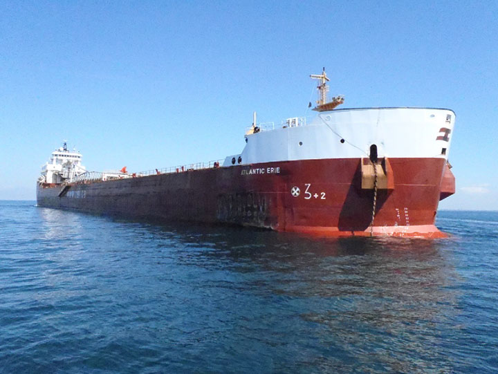
The Atlantic Erie is a dry bulk cargo vessel of steel construction with machinery space and accommodations located aft (Photo 1). The vessel has 5 cargo holds and is fitted with a self-discharging system that allows cargo to be released from the bottom of the cargo holds onto conveyor belts, transported above deck level via an elevator system, and then transferred onto a discharge boom conveyor and off-loaded. The vessel is fitted with an electric bow thruster with a controllable-pitch propeller.
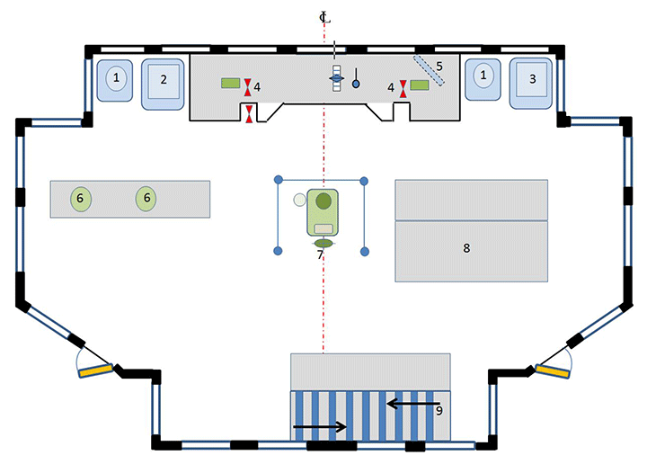
The bridge is equipped with the required navigational equipment, including a 3-cm wavelength radar located right of the centre console and a 10-cm wavelength radar located left of it (Appendix A). Two gyrocompasses, a magnetic compass, a depth sounder and 2 very high frequency (VHF) radiotelephones are also fitted on the bridge.
The vessel is equipped with a differential global positioning system (DGPS), as well as a 3D Navigator draft information system that can be used as an electronic charting system (ECS). The vessel's Electronic Chart Precise Integrated Navigation System (ECPINS), which is also an ECS, is located to the left of the centre console. A repeater monitor for the ECPINS is mounted on the deckhead above the centre console. There was no voyage data recorder (VDR) installed on board, nor is there any regulatory requirement for vessels of this class constructed prior to 01 January 2012 to be fitted with a VDR or a simplified voyage data recorder (S-VDR).Footnote 1
Description of the channel
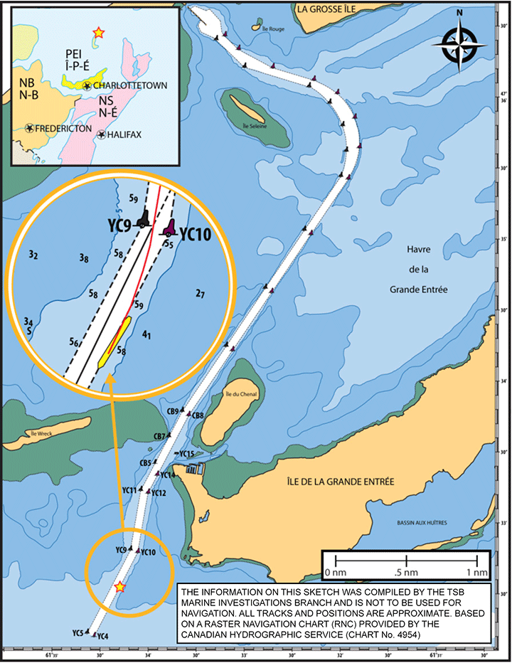
Mines Seleine is a rock salt mining operation located on La Grosse Île, Îles de la Madeleine, Quebec. The rock salt is shipped from a dock located on the northern side of Havre de la Grande Entrée. The harbour is a lagoon, and a navigation channel connects the dock to the open sea south of Île de la Grande Entrée (Appendix B). This channel is a non-compulsory pilotage area; however, the tug Spanish Mist is available to assist with docking and undocking and to monitor the position of the buoys marking the channel. In winter, the tug maintains a track through the ice in the channel and turning basin; it also escorts vessels through the track.
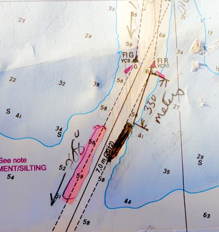
The navigation channel leading into Mines Seleine is 5.5 nautical miles (nm) in length and 100 m wide along its entirety, with the following exceptions: the channel increases in the turn within the harbour to a maximum width of 186 m, and a triangular transition area between the dock and the turn has a maximum width of 166 m at the apex. The width of the channel also decreases to 89 m at buoy YC10. This is because in 2012, buoy YC10 was shifted 11 m to the west of its advertised position in order to mark a rock ledge that encroaches into the channel. A Notice to Shipping (NOTSHIP) indicating the relocation was issued on 26 April 2012. The advertised depth for the entire channel is 7 m.
The sailing directions advise mariners to be very cautious when entering the harbour: less water than charted is to be expected due to continual silting and shifting sandy shoals. Also, buoys may be moved from the charted position to mark the present navigable channel. Mines Seleine can be contacted for up-to-date information on the channel.Footnote 2
The outer portion of the channel is delimited by 4 red starboard-hand buoys and 3 green port-hand buoys (Appendix B). These buoys are maintained by the Canadian Coast Guard. The inner portion of the channel is delimited by 14 red starboard-hand buoys and 14 green port-hand buoys (Appendix B). These buoys are maintained privately by Mines Seleine. At the time of the occurrence, all of the buoys were unlit winter spars. There are also 2 sets of fixed ranges, 1 of which marks the channel between YC5 and YC9, and a sector light to assist with navigation in the channel.
The channel is dredged regularly (every 2 to 3 years) by Mines Seleine. The most recent dredging was carried out in 2014.
History of the voyage
Approximately 2 weeks before the occurrence, the master learned that the vessel would be proceeding to Mines Seleine at Grande Entrée. In preparation, the master contacted the master of the bulk carrier Salarium ,Footnote 3 which routinely operates out of this port, to ask about any issues or hazards in the channel. The master was advised of a shallow area within the channel between buoys YC5 and YC9. This information was then added to paper navigational chart no. 4954 carried on board the vessel (Appendix C).
On the inbound voyage, on the night of 10 January 2015, winds were northwest at 35 knots and gusting, and blowing snow reduced the visibility. After taking into consideration the weather conditions and the fact that the inner portion of the channel was ice covered, which restricted the set of the vessel due to wind, the master concluded that it was safe to transit the channel to the dock. The tug met the vessel at the outermost buoys and advised the master of the Atlantic Erie that the buoy positions had been checked and were found on position.
The Atlantic Erie then followed the tug inbound through the channel, making use of both sets of range lights. The searchlights were used to locate the buoys marking the channel, and 2 crew members were positioned on the bow as lookouts. In the vicinity of buoy CB8 (Appendix B), the vessel entered ice and the Atlantic Erie followed the track through the ice to the dock. As the vessel proceeded in the channel, the ECPINS was displaying an NTX chartFootnote 4 of the area, but it was not used to assist in navigation. The NTX chart had last been updated in March 1998.
On 10 January at 2130,Footnote 5 the Atlantic Erie secured at the Mines Seleine dock in Havre de la Grande Entrée and commenced loading rock salt at 2205. The vessel was shifted numerous times to allow loading, and the engine, thruster, and a tug were used to keep the vessel alongside in a strong westerly wind. The master was required on the bridge during loading and throughout the night to keep the vessel alongside the dock.Footnote 6
Loading was completed on 11 January at 1110, and the vessel departed the dock 25 minutes later with the assistance of the tug. The master and helmsman were on the bridge. By 1235, the heading was aligned with the channel, and the vessel, under the conduct of the master, proceeded outbound at a speed of 5 knots, following the tug and the track through the ice-covered water. The wind was from the west-northwest at 25 knots, gusting to 30 knots, and visibility was good. The second officer, who was serving as the officer of the watch (OOW), joined the master and helmsman on the bridge immediately after the vessel was clear of the dock.
As the Atlantic Erie proceeded outbound following the tug, the master was standing at the centre console and monitoring the vessel's progress visually using the buoys. From the centre console, the ECPINS repeater monitor on the deckhead was visible to the master. The ECPINS was displaying the same NTX chart as on the inbound voyage, and the master used it to observe the wind speed and direction and the difference between the heading and course made good (CMG). The master also used it to verify the distances to course alterations and to occasionally cross-check the vessel's position. The OOW was monitoring the vessel's progress on the port radar using parallel indexing while also monitoring the buoys on either side of the vessel as they passed.
At approximately 1315, the Atlantic Erie exited the fast ice and entered open water in the vicinity of buoy CB8. At this time, the tug proceeded back toward the dock at Mines Seleine, and the Atlantic Erie continued outbound in the buoyed navigation channel, increasing speed to 7 knots. Upon passing the western tip of Île de la Grande Entrée, the OOW ceased parallel indexing, as there were no prominent features to use. The master continued to navigate visually using the buoys, and the OOW was asked to assist by monitoring each buoy as it approached and giving a distance off and all clear once the vessel had passed it.
At approximately 1322, the master advised the OOW that the ECPINS was indicating that the vessel was outside the channel. After checking the depth sounder, which indicated 0.7 m beneath the keel, and visually verifying that the vessel was aligned between the next set of buoys, YC11 and YC12, it was concluded that the ECPINS was not displaying the vessel's position accurately. No further verification of the ECPINS was done at this time, nor was the vessel's position plotted on the chart.
At the next set of buoys, YC11 and YC12, the master completed a course alteration of 18° to port, bringing the vessel onto a course of 189° true (T). To compensate for the winds, the vessel's heading was 195°, with a course made good of 189°T. In preparation for the upcoming alteration to starboard, the master favoured the port-hand buoys in order to maximize the sea room on the port side and account for the set to port. The turn was to be initiated once the vessel was approximately 1.5 ship lengths from buoys YC9 and YC10.
At 1325, the ECPINS was displaying the vessel's position as re-entering the navigation channel. Around that time, the master checked the vessel's position on the ECPINS, which corroborated the position that he had determined using the buoys. To determine the wheel-over point for the upcoming starboard turn, the master then estimated the distance back from the buoys visually, and verified it by using the ECPINS to estimate the distance back from the buoys relative to the length of the vessel icon displayed on the ECPINS screen.
At approximately 1326, the master gave a helm order of 10° to starboard to commence the course alteration of 18° to 207°T. After approximately 20 seconds, there was no change in the vessel's heading, so the master ordered 20° to starboard, followed very closely by hard to starboard. The master also increased the telegraph to full ahead to assist the vessel in turning. As the vessel began to turn to starboard, the master asked the OOW to watch buoy YC10 on the port side and advise of its distance off as the vessel passed.
When buoy YC10 passed amidships, the rudder was returned to amidships to slow the turn to starboard and settle up on the next course, which was marked by a set of ranges. Once the vessel was past and clear buoy YC10, the OOW advised the master. Visually referencing the buoys ahead, YC4 and YC5, as well as the difference between the heading and the CMG on the ECPINS, the master determined that the vessel was on the port side of the channel and setting further in that direction. The ranges marking this leg of the channel, which were located astern of the vessel, were not referenced. The master ordered the helmsman to apply starboard helm and, at 1327:23, the Atlantic Erie 's rate of turn began to increase. However, approximately 15 seconds later, the vessel made contact with the bank southeast of the buoyed navigation channel at a speed of 7.5 knots. The rate of turn and the vessel's speed began to reduce and, at 1329, the Atlantic Erie grounded just outside the navigation channel between buoys YC10 and YC4 (Appendix B).
Events following the grounding
Upon grounding, the master contacted the tug Spanish Mist and asked it to return and assist. Several attempts to free the vessel were made, both under its own power and with the assistance of the tug, but with no success. The master and crew plotted the vessel's position using the DGPS, assessed the extent of damage, monitored internal and external soundings, and calculated the vessel's existing stability as well as its stability if refloated. The vessel's owner and the Canadian Coast Guard (CCG) were then advised of the grounding.
On 12 January, divers completed an underwater survey of the vessel to further assess the damage, and the next day, approximately 5000 metric tons of rock salt was off-loaded to lighten the vessel. On 14 January, the vessel was de-ballasted and refloated at high tide with the assistance of 2 tugs. The Atlantic Erie then proceeded to anchorage, where a surveyor from the vessel's classification society and a marine inspector from Transport Canada Marine Safety and Security (TCMSS) completed an internal inspection. A Condition of Class was issued, and the vessel was ordered to Sept-Îles, where an underwater inspection was completed.
Damage to the vessel
The vessel sustained damage to the bottom shell plating and internals in way of double-bottom water ballast tanks No. 1 Port, No. 2 Port, No. 3 Port, No. 4 Port, and No. 4 Centre. The bottom shell plating was cracked in the forepeak tank in the vicinity of the bow thruster tunnel and in water ballast tank No. 1 Port in the vicinity of frames 222 and 217. Significant buckling of the bottom shell plating and structure was visible along the length of the vessel.
Personnel certification and experience
The master held a valid Master, Near Coastal certificate issued in 1991 and had sailed in various capacities since 1972. The master joined the company in 1996 and had sailed as master since 2007, serving the previous 2 years on this vessel. Although Îles de la Madeleine was not a regular port of call for the Atlantic Erie , the master had made about 8 prior visits to this port; the last one before the occurrence was in September 2014. The master had a bridge resource management (BRM) certificate issued on 15 March 2002, and had completed Human Element, Leadership and Management (HELM) trainingFootnote 7 in February 2013.
The OOW held a Watchkeeping Mate certificate issued on 18 June 2013 and had worked with the company as a second and third officer since obtaining his certification. He had worked on this vessel for 1 year.
The helmsman held a Bridge Watch Rating (BWR) certificate and had been sailing since 1969, serving as helmsman on this vessel since 2009.
Vessel certification
The Atlantic Erie was certified and equipped in accordance with existing regulations. The vessel was in class with Lloyd's Register of Shipping and had undergone a classification society survey on 18 April 2014, at which time it was recommended that the vessel be retained within class.
The Atlantic Erie operated under a safety management system (SMS), which is referred to by the company as the CSL vessel management system (CVMS). The vessel held an interim safety management certificate in accordance with the requirements for the International Safety Management (ISM) Code under the International Convention for the Safety of Life at Sea (SOLAS) that was issued on 01 January 2015 and was valid until 30 June 2015.Footnote 8 The last external audit of the SMS was conducted on 25 October 2013. The company held a valid interim document of compliance that was issued on 17 December 2014 and was valid until 16 June 2015.
Environmental conditions
At the time of the occurrence, the vessel was navigating in daylight in open water. The weather was overcast and the visibility was clear. The air temperature was -10°C, and the wind was west-northwest at 25 knots, gusting to 30 knots. Scheduled high tide of 0.9 m above chart datum was at 1239, and there was no appreciable ebb tide at Grande Entrée in the following hour. At the time of the occurrence, there was a current of approximately 1 to 2 knots flowing west to east in the waters south of Île de la Grande Entrée, creating a cross-current in the outer portion of the channel.
Floating aids to navigation
There are a number of factors that affect the accuracy of a buoy's position. These include prevailing atmospheric and sea conditions, tidal and current conditions, seabed conditions, and the fact that buoys are moored to anchors by varying lengths of chain and may drift about their charted positions within the scope of their moorings.Footnote 9 For these reasons, buoy positions shown on nautical charts are considered to be approximate positions.
The scope of a buoy from its charted position can be calculated by taking into account the water depth (depth at chart datum and height of tide) and the length of the mooring. As an example, at the time of the occurrence, buoy YC10 had a mooring length of 18.3 m. At the buoy's charted position, the depth of water to chart datum was 7.2 m and the height of the tide was 0.9 m above chart datum for a total depth of water of 8.1 m. The scope of buoy YC10 would therefore have been 16.4 m, meaning that the buoy could drift 16.4 m from the charted position in any direction.
At the time of the occurrence, the scope of the buoys at the outer limits of the navigation channel was as indicated in the table below.
| Buoy | Charted depth | Mooring length | Scope |
|---|---|---|---|
| YC4 | 8.5 m | 15.2 m | 11.9 m |
| YC5 | 8.5 m | 15.2 m | 11.9 m |
| YC9 | 7.7 m | 15.2 m | 12.5 m |
| YC10 | 7.2 m | 18.3 m | 16.4 m |
Electronic navigational charts
Up until the late 1990s, the manufacturer of ECPINS made its own electronic navigational charts (ENCs) to run on its ECSs in a format known as NTX. With advances in the industry, the S-57 format was accepted as the international standard, and regulations were implemented to take this into account. Also, the Canadian Hydrographic Service (CHS) was identified as the authorized producer of ENCs in Canada. CHS produced its first S-57 chart in 1997. The ECPINS manufacturer ceased producing ENCs in the late ‘90s, but continued to support their charts through an updating service as late as 2006.
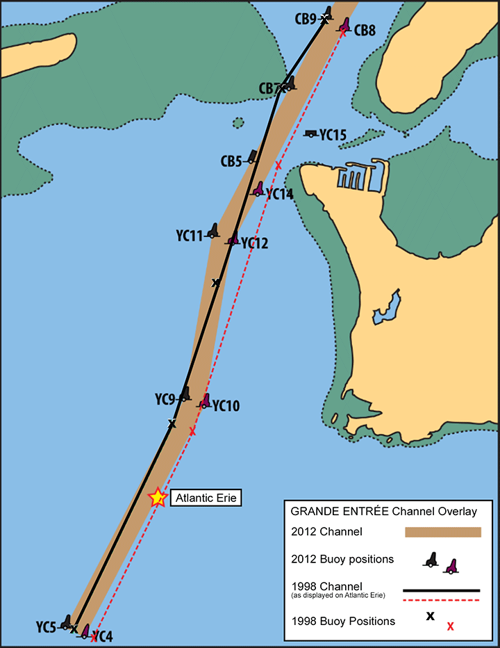
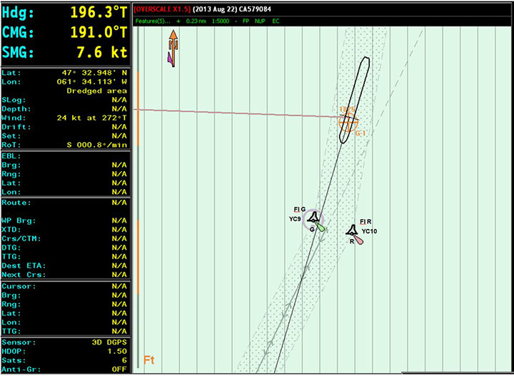
On the occurrence voyage, the Atlantic Erie 's 3D Navigator was displaying an up-to-date version of chart CA579084, an S-57 format chart that was produced by CHS in 2012. The ECPINS was displaying chart C4954NT, an NTX format produced by the ECPINS manufacturer. It had last been updated in March 1998, and showed the location of the channel and buoys at that time.
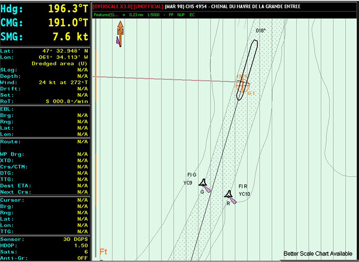
The location of the channel depicted on CHS chart CA579084 and NTX chart C4954NT differed, as did the depictions of the buoy locations (Figure 1). Specifically, on the NTX chart, buoys YC9 and YC10 were shown as being 125 m further south-southwest in the channel than they were at the time of the occurrence.
The NTX chart had been loaded manually the night before the occurrence; it was displayed on the ECPINS during the inbound voyage but was not used for navigation. On the day of the occurrence, the NTX chart was displayed on the ECPINS from the time of departure until the time of the grounding. Chart CA579084 was also loaded on the ECPINS, but was not being displayed.
The electronic charts for the ECPINS on the Atlantic Erie were accessed through the ECPINS hard drive, where the charts were stored in a directory with numerous subfolders. The CHS S-57 charts were located in folders named to match the CD collections issued by CHS. There was also a folder named “OSL,” which is the name of the ECPINS manufacturer. This folder contained digital charts in the NTX format. The last update applied to these charts had been issued in 1999. Included in this folder was chart C4954NT.
The Atlantic Erie 's SMS instructs the navigating officer to delete all previously installed ENCs and to install the charts found on the new chart CD, received every 3 months. The updating of electronic charts on board the Atlantic Erie was completed as required for S-57 charts. Corrections had been applied to chart CA579084, and it was up to dateFootnote 10 with the latest correction dated 22 August 2013. Monthly records of the digital chart updates were completed and sent to the office ashore.
Passage planning and monitoring
A vessel's passage plan is intended to enhance safety by highlighting high-risk areas and providing key information in a format that is readily available to those involved in the vessel's navigation. A passage plan helps to create shared situational awareness among bridge team members as the voyage progresses and must be completed before proceeding on a voyage.Footnote 11
Passage planning consists of 4 stages:
- Appraising all available information about the intended voyage, including reviewing the relevant charts and publications; predicting the vessel's condition; assessing the expected dangers; and gathering information about environmental and local weather conditions.
- Planning the intended voyage, and identifying no-go areas and areas where special precautions must be taken.
- Executing the voyage plan while taking into account the prevailing conditions.
- Continuously monitoring the vessel's progress against the intended plan throughout the voyage and gathering the pertinent local warnings.
The Atlantic Erie 's SMS described the 4 stages of passage planning and provided checklists to be used during these stages. The checklists contained a number of items, including verifying that
- the electronic chart display and information system (ECDIS)Footnote 12 is up to date;
- the ECDIS route is auto-checked for errors;
- the wheel-over points are marked on the chart; and,
- the parallel index data is inserted on the chart.
For the occurrence voyage, each of the above items had been marked as completed.
The company's SMS included a template to assist with passage planning. The template included rows on which to enter details of each leg of the voyage, including waypoint latitude and longitude, position fixing method and frequency, and minimum under-keel clearance. The template also included lines on which to enter the departure and arrival drafts. A general information section was provided to capture details on any risks, hazards, currents, tides, weather or other relevant information. Lines for the signatures of the navigating officer, master, and all other deck officers were included on this document, which was to be signed after it had been reviewed.
A passage plan for the occurrence voyage from Grande Entrée to Bay Roberts, Newfoundland and Labrador, had been completed. Among other things, it contained:
- departure drafts recorded as 7.31 m forward and 7.31 m aft, which differed from actual departure drafts recorded as 7.25 m forward and 7.35 m aft in the cargo book;
- entries to indicate the method of position fixing for each leg of the passage (marked as “Visual/Radar/ECPIN”), but no entries for the frequency of position fixing;
- the minimum under-keel clearance for each leg of the passage, but all 20 within the navigation channel were inaccurate;
- a reference to the chart for parallel indexing information, although no parallel indexing information had been added to chart no. 4954.
The SMS provided direction to the master to approve and sign the passage plan when completed, ensuring compliance with local, international, and company requirements. This included reviewing routes applied to paper and electronic charts, and confirming that the safest passage had been planned with due regard to hazards along the chosen route. The passage plan for the occurrence voyage had been signed by the navigating officer, but had not been signed by the master.
The SMS also included a departure checklist, which required verification that the passage plan was completed and signed off, and that courses were marked on the charts (including those on the ECDIS, if fitted). This item required a positive answer; otherwise, the vessel was to be considered in a no-go situation. The checklist also included a list of all navigational equipment, which was to be checked in order to determine whether it was functioning correctly.
For the occurrence voyage, the checklist item requiring verification of the passage plan had been marked as complete, but there were no initials on the checklist to indicate who had completed the check. The list of navigational equipment had been marked as being checked for relevant items, with the exception of the ECDIS, which was marked as not applicable.
Passage monitoring is also addressed in the SMS, which indicates that, in restricted waters, frequent or continuous track monitoring is required by the use of radar and parallel indexing, that advantage is to be taken of all navigational equipment fitted, and that buoys should not be used for position fixing but may be used for guidance. The SMS specifies that in order for the OOW to know exactly where the vessel is at all times in relation to the intended route, position fixing at intervals of no more than 6 minutes by visual bearings or radar ranges and bearings is required when arriving to or departing from a port.
The vessel carried paper chart no. 4954, which was up to date. It included plotted positions from a previous transit into Grande Entrée. The paper chart did not contain any plotted positions from the occurrence voyage. The bridge logbook included 2 entries for the transit outbound, 1 at 1235 to indicate that the vessel had turned and was outbound, and another at 1329 to indicate that the vessel was aground.
Safety management system
The objectives of the International Safety Management (ISM) Code adopted by the IMO are “to ensure safety at sea, prevention of human injury or loss of life, and avoidance of damage to the environment”.Footnote 13 These are addressed by implementing safe practices in vessel operations and promoting a safe working environment through the establishment of safeguards against all identified risks and through continuous improvement of the safety management skills of personnel ashore and on board vessels.
The Atlantic Erie was ISM-certified by Lloyd's and, on board the vessel, the responsibility for implementing the SMSrested with the master. To verify the effectiveness of the company's SMS and the compliance of the officers and crew, the company had an internal SMS audit program, whereby internal audits were conducted annually by vessel management. Auditing of the SMS was the responsibility of the company's marine, safety and quality superintendent.
In September 2013, the superintendent conducted an internal audit on board the Atlantic Erie. Among the items verified were passage planning and hours of work or rest records. A non-conformity (NCR) regarding passage planning was noted, indicating that routes and parallel indexing information were not found on charts for the passage from Montréal, Quebec, to Les Escoumins, Quebec, that passage plans were not complete from berth to berth, and that the under-keel clearance was not accounted for.
The process for correcting this type of NCR was for the navigating officers to correct the errors on the passage plan and/or add the missing information. The passage plan would then be submitted to the designated person ashore (DPA) as objective evidence that effective corrective action has been taken. In October 2013, the master cleared this NCR, indicating that the routes had been added to the charts for the specified voyage and the under-keel clearance applied.
In October 2014, the superintendent again conducted an internal audit on board the Atlantic Erie , which included verifying the passage planning and hours of work or rest records. An NCR regarding passage planning was again noted, indicating that routes and parallel indexing information were not found on charts of the St. Lawrence Seaway and the navigation channel at Grande Entrée, Quebec, that passage plans were not complete from berth to berth, and that the under-keel clearance was incorrect. In November 2014, the master cleared this NCR, indicating that adjustments to the passage plan had been completed.
The master involved in both the above cited cases was the master involved in this occurrence.
Bridge resource management
BRM is the effective management and use of all resources, human and technical, available to the bridge team to ensure the safe completion of the voyage. BRM includes skills, knowledge, and strategies on workload management, problem solving, decision making, teamwork, and situational awareness, especially during critical operations. Specifically, bridge team members are responsible to maintain overall situational awareness, as well as for their individual duties. They also have a duty to work as a team to help prevent single-point failure, which may occur when only 1 person is responsible for a safety-critical task and that person has no back-up to help identify possible errors. The exchange of information is necessary for team members to work together towards a common goal. Ineffective communication can result in crew members having different understandings of the unfolding situation.
Hours of work and rest
Both management and employees have a responsibility to manage the work schedule to minimize the risk of fatigue. The SMS stated that the master must ensure that the master and every crew member have at least 6 consecutive hours of rest in every 24-hour period, and at least 16 hours of rest in every 48-hour period, in order to ensure that crew schedules, at minimum, meet the requirements set out in the Marine Personnel Regulations (MPR) for hours of rest.Footnote 14
The master was also responsible for having each crew member complete a monthly record of hours of work or rest, which was then verified on board. Management ashore did not complete spot checks or verify the monthly record of hours of work or rest for each employee.
The SMS internal audit reports for 2013 and 2014 included a review and verification of hours of work or rest records. There were no observations or non-conformities noted. The same was done during external audits conducted by the vessel's classification society in 2010 and 2013, also with no non-conformities noted.
During the 48-hour period preceding the occurrence, the master's hours of work or rest record showed the master had the following rest periods:
- 09 January: 17 hours, from 1500 to 0800 the next day
- 10 January: 2 hours, from 1300 to 1500
- 11 January: 1 hour, from 0200 to 0300
- 11 January: 1 hour, from 0400 to 0500
In the 24 hours preceding the occurrence, the master's hours of rest were less than the regulatory requirement. The master's monthly hours of work or rest record for January showed no other period where the master's hours of rest were less than the regulatory requirement. All other bridge team members' work or rest schedules met regulations.
Prior to the occurrence, the master was on the bridge for most of the night to use the vessel's engine and communicate with the tug to keep the vessel alongside during loading in strong offshore winds. The vessel needed to be shifted up and down the dock throughout the night to enable loading in different cargo holds.
General description of sleep
Sleep is divided into 5 different stages. Stage 1, the lightest stage, is the transition between wakefulness and sleep. Stage 2 lasts for about 20 minutes, during which time the body prepares for deep sleep. Stages 3 and 4 are the deepest stages, providing for restorative sleep. Following deep sleep, there is a return to stage 2, which is followed by rapid eye movement (REM) sleep to complete a cycle. One sleep period is made up of 4 to 6 repeating cycles.Footnote 15 Frequent awakenings limit the quantity of sleep and disrupt its quality, and may result later on in performance decrements that can include reduced vigilance, impaired decision-making, inability to concentrate, distraction, and loss of awareness in critical situations.Footnote 16
TSB Watchlist
Safety management and oversight is a 2014 Watchlist issue
The Watchlist is a list of issues posing the greatest risk to Canada's transportation system; the Transportation Safety Board of Canada (TSB) publishes it to focus the attention of industry and regulators on the problems that need addressing today.
The TSB identified safety management and oversight as a 2014 Watchlist issue. The solution will require all operators in the marine industry to have formal safety management processes. In addition, Transport Canada (TC) must oversee companies' safety management processes, since some transportation companies are not managing their safety risks effectively. TC oversight and intervention has not always proven effective at changing companies' unsafe operating practices.
Analysis
Events leading to the grounding
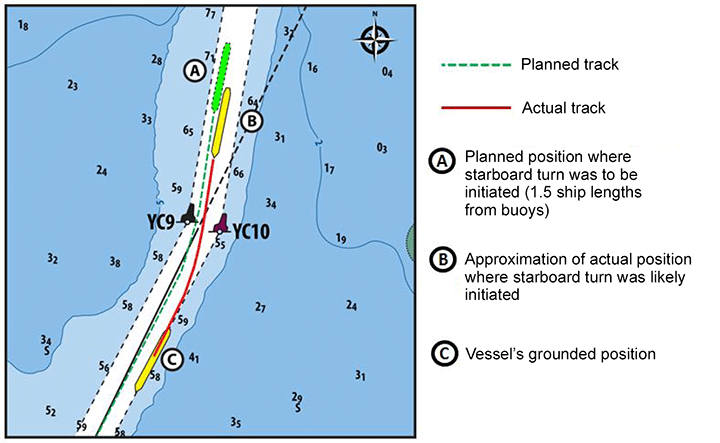
The Atlantic Erie was navigating in a narrow channel with limited space to manoeuvre. In preparation for an upcoming turn, the master planned to position the Atlantic Erie along to the starboard side of the channel and initiate the turn once the vessel was approximately 1.5 ship lengths (338 m) from buoys YC9 and YC10 (Figure 2). The master was navigating visually, relying solely on the buoy positions, and was using the Electronic Chart Precise Integrated Navigation System (ECPINS), which was displaying an outdated chart, to verify distances to alteration points.
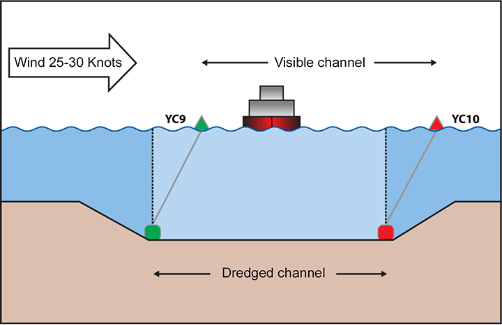
On approach to the turn, the strong wind and cross current were setting the buoys to the east, giving the master the impression that the vessel was close to the starboard side of the channel when it was in fact near the centre (Appendix D). The outdated ECPINS chart likely corroborated the master's belief that the vessel was on the starboard side of the channel, because it no longer depicted the channel accurately and therefore showed the vessel on the starboard side, rather than near the centre where it actually was (Appendix E).
The outdated ECPINS chart was also displaying buoys YC9 and YC10 as being 125 m further south-southwest along the course line than their actual location in the channel. By using the buoy positions indicated on the ECPINS to verify the wheel-over position, the master likely initiated the turn when the vessel was only 213 m, or 0.9 ship lengths, from the actual buoy positions, later than intended (Figure 2).
The bridge team were not using all available bridge resources to monitor the vessel's position in the channel and lost situational awareness. Because the turn was initiated when the vessel was in the centre of the channel and further south than intended, there was not enough sea room to overcome the environmental conditions and complete the manoeuvre with the helm applied. However, the bridge team perceived the turn to be proceeding as intended while the Atlantic Erie crossed over to the port side of the channel and ran aground.
Monitoring
To ensure the safe passage of a vessel, navigators use visual cues and information from multiple types of navigational equipment and aids to navigation. This assists in maintaining situational awareness with respect to the vessel's progress and allows for cross-checking to identify potential equipment or human errors. The use of all available navigational equipment for monitoring is especially important where there is little room for deviation from the intended route. In port approaches or restricted waters, the vessel's position is best monitored through a combination of visual references such as leading lines, headmarks and buoy/beacons used together with radar parallel indexing, and by plotting the vessel's position.Footnote 17
In this occurrence, the bridge team had a range of navigational equipment available to assist with monitoring the vessel's progress and determining the distance to course alteration points. The vessel's safety management system (SMS) also included guidance on effective monitoring, noting that advantage is to be taken of all available navigational equipment. However, prior to the alteration, the bridge team was primarily determining the vessel's position within the channel using only 1 method: visually using the buoys. While buoys may be used as reference points during navigation, they are not reliable for positioning because they can drift about the charted position when influenced by environmental conditions. Buoys should not be used as fixed points for navigation purposes but, when used with other aids to navigation, provide reassurance and orientation and allow for early detection of set and drift.Footnote 18
As the vessel approached the turn, the officer of the watch (OOW) had been asked to monitor the buoys, but this method of monitoring was essentially redundant because the master was also using the buoys to navigate. By relying solely on the floating aids to monitor the passage of the vessel, the master did not have an effective way to cross-check the vessel's position and help him detect errors, creating a situation where the master lost awareness of the vessel's actual position within the channel.
By using buoys, which were being set off their charted positions by the prevailing environmental conditions, as the primary method of navigation, the bridge team lost awareness of the vessel's actual position within the channel.
To navigate visually in an effective manner, mariners rely on fixed navigational aids or landmarks to determine the vessel's position. Floating navigational aids may be used as a reference but not for positioning. Mariners then determine the vessel's position relative to these fixed marks by establishing a line of position. Without the use of any equipment, a line of position can be determined by lining up two fixed objects in a natural transit or to use range markers established ashore for this purpose. If these options are not available, a gyro repeater may be used to give a visual bearing from a fixed object ashore to establish a line of position. In order for visual navigation to be effective, fixed objects ashore must be identified and a structured means of determining the vessel's position relative to these objects must be employed. Preplanning by studying the navigational chart to establish these visual cues is essential.
The bridge team was not referencing the range lights marking the channel between buoys YC9 and YC5 or using any other visual reference of fixed objects ashore, and thereby missed an opportunity to visually confirm the vessel's position within the channel.
If established visual aids to navigation are not used and other fixed visual cues are not identified before the passage, there is a risk of ineffective visual navigation leading to the loss of situational awareness.
Although the master was periodically observing the vessel's position on the ECPINS, the ECPINS was displaying the vessel's position inaccurately and likely contributed to the master's loss of situational awareness. While the bridge team had identified an error with the ECPINS shortly before the occurrence, they did not take the step of verifying the vessel's actual position on the chart. This meant that the discrepancies with respect to the channel location and buoy positions went undetected.
The bridge team did not use all available navigational equipment to verify and monitor the vessel's position, limiting their ability to identify human or equipment errors.
Safety management
Effective safety management requires organizations to be committed to operating safely, to be cognizant of the risks involved in their operations, and to competently manage those risks. On the Atlantic Erie , the safety management system set out, among other things, requirements for passage planning and included a standard passage planning template and checklists as tools to help mitigate the risks of navigational errors.
Although a passage plan had been developed for the occurrence voyage, it was missing certain information (wheel-over positions, frequency of position fixing) and, despite the difficulty of navigation in the channel, the passage plan contained the same degree of detail as when the vessel was sailing in open water. Additionally, several steps to ensure safe navigation had not been taken, despite being marked as complete on the passage planning checklist (e.g. ensuring the ECDIS was up to date, inserting wheel-over points and parallel index data on the chart). These deviations from the intended passage planning procedures set out in the SMS resulted in the bridge team circumventing a number of safeguards in place to prevent navigational errors.
Circumvention of safeguards may result from a mismatch between how written procedures specify work should be performed and the way work actually gets done.Footnote 19 Front-line workers often create “locally efficient practices” to get jobs accomplished quickly, while facing operational pressures such as limited time, limited resources, and multiple goals. “Each operational success achieved at incremental distances from the formal, original rules [written procedures], can establish a new norm”, and eventually these deviations from the routine become normalized.Footnote 20
Internal audits of the shipboard SMS in 2013 and 2014 also identified issues with passage planning on board the Atlantic Erie . In both cases, the company had issued non-conformity reports (NCR). After the first NCR, the master corrected and submitted the passage plan to the designated person ashore (DPA) as per the usual process. When the non-conformity was issued a second time, the same corrective actions were taken without further examination. Although the items from these previous audits were addressed by the master each time and closed out as being corrected, there was no follow-up by either the company or the master to determine why the problem was recurring and to ensure that the corrective measures taken were mitigating the problem. In order to continuously improve their SMS, a company is required to follow up and re-evaluate the corrective action taken to address non-conformities and prevent recurrence.
If neither the company nor the master follows up to ensure that corrective action taken to address identified non-conformities has been effective, there is a risk that the non-conformities will recur.
Master's hours of work and rest
All crew members must obtain sufficient restorative sleep to perform their job functions safely. The master's rest hours show a pattern of disrupted sleep in the 24 hours leading to the accident and non-compliance with the Marine Personnel Regulations (MPR). These disruptions would not have allowed for periods of deep sleep, which are the most conducive to restorative sleep. Therefore, the master had accrued a level of fatigue in the night preceding the occurrence.
Due to the strong wind conditions on the night of the occurrence, the master was on the bridge for many hours to ensure the safety of the vessel during cargo operations. This was not normally the case during cargo loading; under better weather conditions, the vessel can remain alongside without the assistance of the engine or a tug, which allows the master to leave the bridge and obtain hours of rest. Although the master could have halted the operation or assigned someone else to the task during the night, there is a propensity to carry on with the task at hand and for a master to remain on the bridge in challenging periods.Footnote 21
In this occurrence, not using multiple means to monitor the vessel's position and the loading of an incorrect chart on the ECPINS the previous evening were the factors that led to the grounding. Prior to the course alteration where the grounding occurred, the master had identified an error with the vessel's position as displayed on the ECPINS and had successfully navigated the vessel through 2 course alterations within the narrow channel without the assistance of the tug or track in the ice, suggesting that the master was attentive up to this point. Therefore, although the master had likely accrued a level of fatigue in the night preceding the occurrence, it could not be determined whether it played a role in the occurrence. Nevertheless, masters and any other crew member are all susceptible to fatigue, hence the importance of ensuring that all crew members receive at least 6 hours of consecutive rest to obtain restorative sleep.
If mariners exceed the regulated hours of work and are not properly rested, there is a risk of fatigue-related accidents.
Voyage data recorder
The purpose of a voyage data recorder (VDR) is to create and maintain a secure, retrievable record of information indicating the position, movement, physical status, and command and control of a vessel for the most recent 12 hours of operation. Objective data are invaluable to investigators in seeking to understand the sequence of events and identify operational problems and human factors.
The Atlantic Erie was not fitted with a VDR or simplified voyage data recorder (S-VDR), nor is there a requirement for them on vessels of this class constructed prior to 01 January 2012. However, without time-stamped voice recordings of the helm orders as well as helm order and rudder position indications, the Transportation Safety Board of Canada (TSB) investigation could not determine the precise time at which the starboard turn was initiated and how the helm order was applied.
If voyage data recordings are not available to an investigation, this may preclude the identification and communication of safety deficiencies to advance transportation safety.
Findings
Findings as to causes and contributing factors
- By using buoys, which were being set off their charted positions by the prevailing environmental conditions, as the primary method for navigating, the bridge team lost awareness of the vessel's actual position within the channel.
- Using an outdated electronic chart, which no longer displayed the channel or buoy positions accurately, to verify the wheel-over position likely lead the master to initiate the turn later than intended.
- The bridge team did not use all available navigational equipment to verify and monitor the vessel's position, limiting their ability to identify human or equipment errors.
- Deviations from the intended passage planning procedures set out in the safety management system resulted in the bridge team circumventing a number of safeguards in place to prevent navigational errors.
- Given the environmental conditions and the vessel's position in the channel at the time the turn was initiated, there was not enough sea room to complete the manoeuvre with the helm applied, and the Atlantic Erie ran aground.
Findings as to risk
- If established visual aids to navigation are not used and other fixed visual cues are not identified before the passage, there is a risk of ineffective visual navigation leading to the loss of situational awareness.
- If neither the company nor the master follows up to ensure that corrective action taken to address identified non-conformities has been effective, there is a risk that the non-conformities will recur.
- If mariners exceed the regulated hours of work and are not properly rested, there is a risk of fatigue-related accidents.
- If voyage data recordings are not available to an investigation, this may preclude the identification and communication of safety deficiencies to advance transportation safety.
Other findings
- Although the master had accrued a level of fatigue in the night preceding the occurrence, it could not be determined whether the master's level of fatigue played a role in the occurrence.
Safety action
Safety action taken
Canada Steamship Lines
Following the occurrence, Canada Steamship Lines (CSL Group Inc.) provided the entire fleet with CDs containing charts and sent detailed instructions requiring masters and navigation officers to completely delete all existing charts on the Electronic Chart Precise Integrated Navigation System (ECPINS) and to install the charts provided. A confirmation letter was requested from all vessels when the system had been updated as required and was operational.
In 2015, CSL Group Inc. conducted 6 Human Element Leadership Management (HELM) training sessions for masters, chief officers, chief engineers and 2nd engineers. The subject matter of the course includes: communication, leadership and management, team skills, management systems, situational awareness, decision making, health issues – stress and fatigue, and risk management. CSL Group Inc. has committed to delivering this training to all senior officers in the fleet by the end of winter 2016.
Additionally, 1 master and 1 chief engineer from CSL Group Inc. received further training as HELM mentors. They were dedicated to the fleet for 2015 to deliver on-board mentoring and coaching to help imbed the principles of HELM, BRM, and engine-room resource management (ERM) with the master, chief engineer and all deck and engineering officers on board. These mentors circulated through the fleet for the 2015 navigation season.
During CSL Group Inc.'s 2015 annual fleet conference for senior officers, an interactive case study of another navigation incident was presented which required active participation in identifying root causes and corrective actions to the incident.
This report concludes the Transportation Safety Board's investigation into this occurrence. The Board authorized the release of this report on . It was officially released on .
Appendices
Appendix A - Bridge layout
Note: Bridge layout is not to scale.
Legend:
- Radars
- Electronic Chart Precise Integrated Navigation System (ECPINS)
- 3D Navigator draft information system
- Very high frequency (VHF) radiotelephone handset
- ECPINS repeater monitor
- Gyrocompass
- Helm
- Chart table
- Stairway
