Bridge failure and derailment
Canadian Pacific Railway
Freight train 292-26
Mile 172.5, Brooks Subdivision
Calgary, Alberta
The Transportation Safety Board of Canada (TSB) investigated this occurrence for the purpose of advancing transportation safety. It is not the function of the Board to assign fault or determine civil or criminal liability. This report is not created for use in the context of legal, disciplinary or other proceedings. See Ownership and use of content. Masculine pronouns and position titles may be used to signify all genders to comply with the Canadian Transportation Accident Investigation and Safety Board Act (S.C. 1989, c. 3).
Summary
On 27 June 2013, at 0320 Mountain Daylight Time, Canadian Pacific Railway freight train 292 26, proceeding eastward from Canadian Pacific Railway’s Alyth Yard in Calgary, Alberta, to Medicine Hat, Alberta, derailed 6 tank cars on the Bonnybrook Bridge over the Bow River at Mile 172.5 on the Brooks Subdivision. There was no product loss, and there were no injuries.
Factual information
The accident
Beginning in the week prior to 27 June 2013, record rains upstream resulted in flooding of the Bow River Basin. On 21 June, the Elbow River and the Bow River peaked. During this period, the volume, speed, and turbidity of the river prevented below-water inspections of the Bonnybrook Bridge. All bridge inspections during the flood were conducted at track level. In addition to formal bridge inspections performed by qualified bridge inspectors, other Canadian Pacific Railway (CP) personnel (i.e., transportation and engineering service employees) observed the condition of the bridge multiple times daily to monitor rail alignment and elevation deviations in order to ensure that no movement was occurring. Based on these observations, CP assessed the bridge as suitable for continued rail operations.
On 27 June 2013, shortly after midnight, CP freight train 292-26 (the train) arrived in Alyth Yard (Calgary, Alberta) from Red Deer, Alberta, with 72 loaded cars and 57 empty cars. At 0204,Footnote 1 westbound CP freight train 675-053, with 166 loaded cars of potash, weighing 24 266 tons and 8283 feet long, crossed over the Bonnybrook Bridge on track P1 into Alyth Yard without incident and without any indication of imminent failure.
At about 0310, after performing some switching for train 292-26 and changing crews, the train departed Alyth Yard on track P2, destined for Medicine Hat, Alberta. The train now comprised two 6-axle, AC4400 HP General Motors locomotives, 62 loaded cars, and 23 empty cars. It weighed 9007 tons and was 5358 feet long.
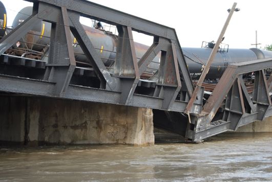
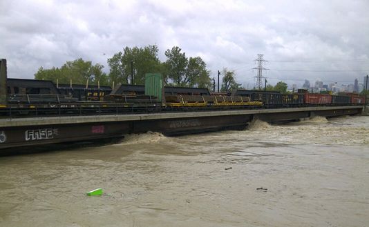
At 0314, with the train travelling at 9 mph, a train-initiated emergency brake application occurred. The train stopped 22 seconds later. After making the necessary emergency broadcast and notifying the rail traffic controller (RTC), the conductor performed an inspection and determined that 6 tank cars (the 63rd car to the 68th car) situated on the Bonnybrook Bridge had derailed in an upright position. The bridge failed at the Pier no. 2 location, under the 67th and 68th cars (Photo 1). There were no injuries, and there was no loss of product.
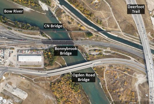
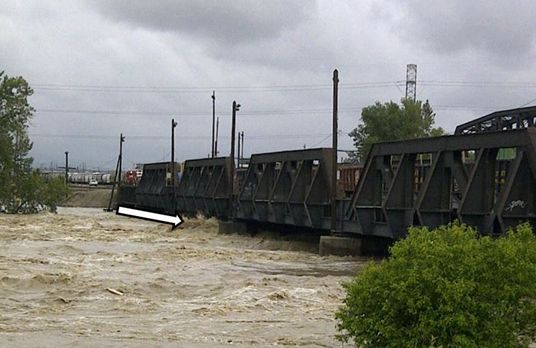
The Bonnybrook Bridge is situated in southeast Calgary and spans the Bow River (Photo 2). The bridge is located at Mile 172.5 of the Brooks Subdivision on CP's main line, connecting it with Alyth Yard. The Bonnybrook Bridge is a key element of CP's east–west rail network.
In the vicinity of the Bonnybrook Bridge, there are 2 other bridges:
- A Canadian National Railway (CN) bridge is situated upstream of the CP Bonnybrook Bridge. The bridge, on CN's GTP Industrial Lead, was built in 1912 and consists of an east abutment, a west abutment, and 2 piers supporting 2 through-truss pinned (TTP) spans and a deck plate girder (DPG) span. The piers rested on and were socketed into the shale bedrock. Unlike the piers on the CP Bonnybrook Bridge, which are aligned with the river flow, the river current strikes the piers of the CN bridge at an angle. The superstructure of the CN bridge was unaffected by the flood waters, but CN inspections conducted on 15 July and 01 August determined that undermining at the north end of the west abutment and large areas of erosion of the Pier no. 2 pedestal and riverbed did occur during the flood.
- The City of Calgary's Ogden Road Bridge is situated downstream of the CP Bonnybrook Bridge. The Ogden Road Bridge was unaffected by the flood waters.
The derailed cars
Information related to the derailed cars is summarized in Table 1.
| Car no. | Car ID | Car typeFootnote 2 | Contents | Date built | Most recent tank test | Load status |
|---|---|---|---|---|---|---|
| 63 | TILX 261251 | AAR211A100W1 | Ethylene glycol (UN 3082) | January 2005 | 2005 | Load |
| 64 | NATX 50264 | 111A100W3 | DURASYN 125Footnote 3 | September 1989 | 2008 | Residue |
| 65 | GATX 211363 | 111A100W1 | Flammable liquid, n.o.s. (UN 1993) | October 2012 | 2012 | Load |
| 66 | CBTX 742965 | 111S100W1 | Flammable liquid, n.o.s. (UN 1993) | December 2012 | 2012 | Load |
| 67 | CBTX 742912 | 111S100W1 | Flammable liquid, n.o.s. (UN 1993) | November 2012 | 2012 | Load |
| 68 | TILX 224072 | 111A100W1 | Flammable liquid, n.o.s. (UN 1993) | February 1992 | 2007 | Load |
The characteristics of the products carried in the derailed cars include the following:
- TILX 261251 was a loaded tank car of ethylene glycol, UN 3082, a colourless, odourless chemical found in many household products, including antifreeze, de-icing products, detergents, paints, and cosmetics. It is poisonous if swallowed. It is not classified as hazardous for transport in North America.
- NATX 50264 was a residue tank car, last containing Durasyn 125, a hydrocarbon designed to extend the service life, and enhance the performance, of lubricants operating under a wide temperature range. It is not classified as hazardous for transport in North America.
- GATX 211363, CBTX 742965, CBTX 742912, and TILX 224072 were loaded tank cars of flammable liquid n.o.s (UN 1993), a combustible, toxic liquid used to dilute bitumen crude oil flow in pipelines and as a solvent in metal polishes, paint thinners, and oil-based stains and paints. The product is commonly called natural gasoline.
Bonnybrook Bridge
The Bonnybrook Bridge was a 465-foot-long, 5-span bridge.Footnote 4 With 4 tracks, this bridge was part of CP's main line, connecting the Brooks Subdivision to the east, and Alyth Yard and the Laggan Subdivision to the west. Traffic over this bridge consisted of about 30 trains per day, not including the switching movements originating from Alyth Yard, which used the bridge.
The bridge, which was oriented at a 58º angle to the alignment of the river and pier, consisted of
- the substructure and foundations, including 2 abutments and 4 piers supporting 2 superstructures;Footnote 5
- a downstream superstructure (fabricated in 1912) supporting 3 tracks (P1, P2, and Old Ogden) on four 100-foot-long through/pony-truss spans and a 66-foot-long through-plate girder (TPG) span; and
- an upstream superstructure (fabricated in 1969) supporting 1 track (New Ogden) on four 100-foot-long skewed ballasted deck plate girder (BDPG) spans and a 66-foot-long skewed BDPG span.
The history of the Bonnybrook Bridge is summarized as follows:
- The original bridge (circa 1897) was a single-track structure that consisted of two 200-foot-long through-truss spans supported on 2 stone masonry abutments and a stone masonry pier. The west stone masonry abutment was located at the Pier no. 4 location. The stone masonry pier was located at the Pier no. 2 location. These stone masonry substructures were supported on concrete caissons founded on the river bottom shale and sandstone similar to that shown in Photo 3.
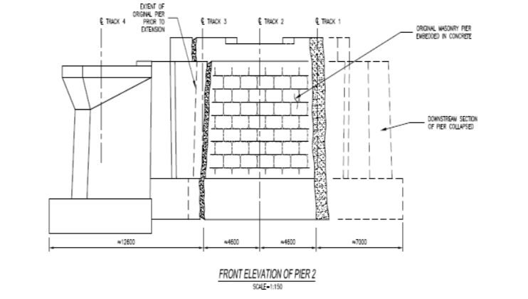
- In 1912, the stone masonry abutments and stone masonry pier were extended to the north (i.e., upstream) and the south (i.e., downstream) to accommodate an additional 2 tracks (Figure 1). The concrete pier extensions were poured against the existing piers without keying or otherwise anchoring the extensions into the masonry piers. The foundations for the concrete extensions at Pier no. 2 and Pier no. 4 were spread footingsFootnote 6 that were supported on shale bedrock at the same elevation as the original stone masonry caisson bases. Additional piers (i.e., Pier no. 1 and Pier no. 3) and a new west abutment were constructed of concrete on reinforced concrete spread footings that were supported on shale bedrock. The concrete extension footing for Pier no. 2 was connected with reinforcing bars to a false footing around the base of the original pier to protect the pier from impact and undermining.
- In 1969, the bridge was further extended north (i.e., upstream) to accommodate a fourth track. This extension was constructed of 5 BDPG spans supported on concrete abutments and piers. The new BDPG extensions were connected by dowels grouted into the 1912 north-side concrete pier extensions. The substructure extensions were founded on spread footings socketed into the shale rock to a depth of between 1.2 and 1.8 m. Drilling indicated that the bedrock is interbedded shale and sandstone bedrock.
Track information
All 4 tracks over the bridge were tangent on a 0.217% ascending grade to the east. From south to north, the tracks were
- P1, a signaled interlocking track (to which interlocking rules applied), which had a maximum permissible speed of 25 mph and was the main track in and out of Alyth Yard;
- P2, a non-main track (to which Canadian Railway Operating Rules [CROR] 105 applied) with a maximum speed of 10 mph;
- the “Old Ogden” yard track, a non-main track (to which CROR 105 applied) with a maximum speed of 10 mph; and
- the “New Ogden” yard track, a non-main track (to which CROR 105 applied) with a maximum speed of 10 mph.
All 4 tracks consisted of 136-pound rail laid on double-shouldered tie plates and fastened with spikes. The rail on track P2 and on the Old Ogden track rested on the bridge timbers and was unanchored. The rail on the New Ogden track rested on the 1969 ballast deck extension and was anchored on treated ties. Track P1 was continuous welded rail (CWR), and the other tracks were jointed rail.
Bridge damage
During site examination, the following was noted:
- At the upstream end of Pier no. 2 (north side), there was a relatively clean separation at the interface between the existing stone masonry pier and the 1912 concrete extension.
- The downstream end of Pier no. 2, a concrete pier extension, had separated at the interface with the original stone masonry pier and had fallen into the river.
- The west end of TTP span no. 2 and east end of TTP span no. 3 were unsupported and extensively damaged.
- The north side bottom chord of TTP span no. 2 was bent.
- Stringers, floor beams, connections, and floor system bracing on TTP spans no. 2 and no. 3 were bent and torn, and had failed in many locations.
- Span bearing components and anchor bolts under the south truss at Pier no. 2 were missing.
- Span anchor bolts under the north truss at Pier no. 2 were bent.
- The rails on the bridge superstructure were bent and twisted, but most of the bridge ties and other track material were salvageable (Photo 4).
- The 5-span 1969 BDPG bridge upstream of the 1912 structure was unaffected, except for a minor lateral displacement of 10 mm to 20 mm between spans no. 2 and no. 3 over Pier no. 2.
Rainfall and flooding prior to the accident
One hundred fifty mm of rain had fallen west of Calgary near Canmore, Alberta, and Exshaw, Alberta, in a 48-hour period by early morning of 20 June. Sporadic, high rainfalls of up to 20 mm per hour were also recorded. Flash floods and mud slides had occurred in several sections upstream of the Bow River Basin.
Some of the resulting flood damage and flood mitigation strategies by CP and other agencies included the following:
- CP's Laggan Subdivision between Calgary and Lake Louise, Alberta, was hardest hit by the rain and high water. Water flowed over the bridge deck at Exshaw (Mile 57.1) on 18 June. Track washouts occurred at Cougar Creek near Canmore (Mile 68.7) on 19 June.
- Water flowed over the track and bridge decks, and culverts were washed out at numerous locations between Lake Louise and the City of Calgary. Trees and debris had to be cleared out and away from culverts and bridges.
- Near Banff, Alberta, a larger culvert was installed at Mile 78.3 to handle water that was released to lower the level of the Lake Minnewanka power plant reservoir. This was the first time since its construction in 1941 that water had been released from the reservoir.
- The water flowed over and closed the Trans-Canada highway, and flooded a transformer at the Cascade power plant, cutting power to Banff and Lake Louise.
- Water was released from the reservoirsFootnote 7 behind the Ghost Lake Dam and Bearspaw Dam and at power plants, adding to the rapidly rising Bow River.
- In the City of Calgary, CP monitored water levels under its bridges. Track repairs were performed at Edworthy Park (Mile 3.5) following track washout. As water levels rose, loaded cars were parked on several bridges as a precaution to prevent span liftoff should the water continue to rise. Closed roads caused traffic chaos, making it more challenging to move materials, equipment, and workers.
- The Laggan Subdivision was out of service from 20 June to 25 June. CP's Crowsnest Subdivision was also affected during this period.
On 20 June, a number of emergency precautions were undertaken by the City of Calgary, including the following:
- At 0802, in response to high water flows, the city's municipal emergency plan was activated, and an emergency operations centre, which serves as the city's multi-agency command centre for large-scale emergencies, was opened. Key personnel from city departments (such as fire, ambulance, police, and sanitation), from external groups (such as power and gas utilities), and from major industries (including CP, Alberta Health Services, and other provincial agencies) joined to support front-line responders.
- At 1016, the city issued a local state of emergency and began deployment of sandbags and construction of berms at key locations, as directed by the Calgary Emergency Management Agency (CEMA).
- At 1417, the city gave mandatory evacuation orders to 6 Calgary communities along the Elbow River. Reception centres were set up at leisure and recreation complexes.
- At 1843, a mandatory evacuation notice was issued for low-lying areas in the Calgary districts of Bowness and Sunnyside. Mandatory evacuation orders were extended to other areas of the city, bringing the total number of communities evacuated to 32. Up to 80 000 Calgarians were evacuated.
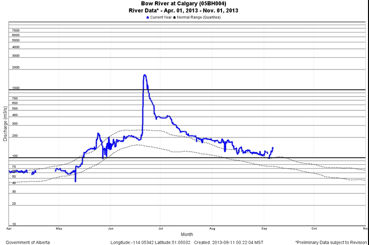
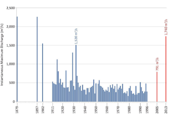
- On 21 June, the Elbow River and the Bow River in Calgary peaked. A water flow rate of 1740 cubic metres per second (m³/sec) was recorded for the Bow River (Figure 2). At least 20 major roads were closed, with no transit service into the core. Several downtown buildings were closed, including Calgary City Hall. A total of 17 bridges over the Elbow River and the Bow River were closed.
Note: The data were taken from a river gauge located about 0.8 km upstream of the confluence of the Bow and Elbow Rivers and 7 km upstream of the Bonnybrook Bridge. These data do not account for the flow in from the Elbow River. Both the Elbow River and the Bow River peaked on 21 June.
On 22 June, restricted access and power outages continued to affect a significant part of the downtown core.
On 23 June, evacuation orders were lifted in all areas except the downtown core. Water flow rates in the Bow River and Elbow River were down significantly.
On 24 June, parts of the downtown remained closed and without power. About 80% of C‑Train (public light rail transit) service was restored. Several road closures remained in effect. Most communities were partially or fully reopened, and power was restored to all affected areas by 28 June.
Inspection of the Bonnybrook Bridge during the Calgary flood
During the Calgary flood, water volume, speed, and turbidity prevented underwater inspections of the Bonnybrook Bridge. The bridge inspections were being conducted at track level. In addition to these formal bridge inspections performed by qualified bridge inspectors, CP transportation and engineering service employees were observing the condition of the bridge multiple times daily to monitor for rail alignment and elevation deviations and to ensure that no movement was occurring.
Between 20 June and 24 June, there were 18 bridge inspections (including measurement of water elevation) by CP engineering supervisors. During the height of the flood (21 June), the water level had risen to about 8 inches below the bridge girders (Photo 5 and Photo 6).
Other actions taken in the vicinity of CP bridges during the flood included
- staging of equipment at bridge locations to remove debris accumulating at bridge piers
- placement of rip-rapFootnote 8 stone at abutment and bank locations
- parking loaded rail cars on bridges to prevent displacement of a bridge if it were struck by debris or flow.
Inspection of other bridges during the Calgary flood
During the flood, the City of Calgary conducted the following inspections:
- All city Elbow River bridges and Bow River bridges were inspected daily (and in some cases several times daily) during the early days of the event. Visual inspections included looking for the telltale signs of foundation settlementFootnote 9 (vertical and horizontal misalignments along bridge elements).
- With no movement being detected, the last daily inspections of city bridges took place on 28 June. At this point, the city was confident that water levels had sufficiently receded such that no further damage would be incurred. All city bridges were then reopened.
Historical flooding of the Bow River
The Red Deer River, Bow River, Oldman River, and South Saskatchewan River are part of the South Saskatchewan River Basin (SSRB), one of 7 major river basins in Alberta. Severe flooding of the Bow River has occurred several times since the late 1800s (Figure 3) and has included the following events:
- The worst recorded flood in Calgary occurred in 1879, but there was little infrastructure and few people were affected.
- Another large flood occurred in June 1897, when the Bow River flooded after several days of intense rainfall. Bridges were torn out and buildings were flooded.
- Other floods occurred in June 1902, with a water flow rate of 1530 m³/sec, and in June 1929, with a water flow rate of 1320 m³/sec.
- Heavy rains in June 1932 produced a Bow River peak flow of 1520 m³/sec that flooded parts of Calgary. The city was fortunate that year, as the recently built Glenmore Reservoir Dam held back much of the Elbow River flooding.
- Another major flood (791 m³/sec) occurred in June 2005. There were 4 fatalities, and insurance and infrastructure losses amounted to $400 million. The year 2005 was the wettest in Canada in 6 decades, according to Environment Canada.
The volume of water in southern Alberta Rivers had—in most cases—never previously reached the recorded water flow rates that occurred in 2013. Appendix A shows the estimated peak river flows.
Meteorology
In the week before the flooding, meteorologists were aware that there was the potential for severe thunderstorms and heavy rain in Alberta. Computer models suggested a unique weather pattern that could lead to flooding.
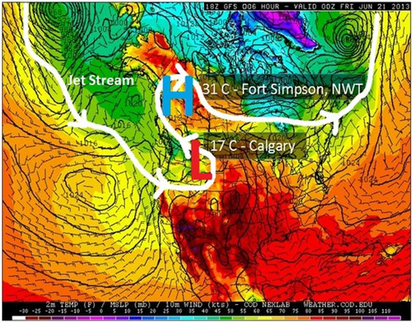
An upside-down weather pattern had taken shape across Western North America earlier that week. “Upside-down” refers to a jet stream pattern in which there are warmer temperatures to the north, as compared to the south.
The jet stream is the roughly continuous corridor of strong high-altitude winds (at the cruising altitude of passenger aircraft) that moves from west to east across the mid-latitudes. The jet stream pattern that dictates the weekly variation in weather has ups and downs (i.e., what meteorologists call “ridges” and “troughs”).
Sometimes, the jet stream pattern gets stuck or “blocked”. This was the condition that took shape across Western North America during the week of 16 June. The large “up”, or ridge, in the jet stream, resulting in record warmth in Alaska and hot weather across parts of Canada's North, blocked a strong dip in the jet stream from moving quickly from west to east. In Figure 4, the “H” represents high pressure, or the “up” in the jet stream, and the “L” represents low pressure, or the “down” in the jet stream.
With the counter-clockwise winds around this low-pressure system, a channel of very moist air was tapped from the Gulf of Mexico and pulled into Alberta. This atmospheric river of water vapour moved north and then east over the foothills and Rocky Mountains, rising, cooling, condensing, and releasing large amounts of precipitation.
In addition, a late but rapid snowmelt at upper elevations of the Rocky Mountains contributed to the flooding.
Canadian Pacific Railway weather forecasting
The Rail Weather Information System (RailWIS) was developed for CP as its weather threat monitoring and warning system. This system had been the railway's decision support tool for extreme hydrometeorological events for many years. Its components includedFootnote 10
- real-time monitoring and calls regarding critical weather variables within the track corridor;
- automated severe weather alert alarms (SWALs) for key operational thresholds, including extreme temperatures, high winds, and large storms;
- automated quality-controlled warnings issued by Environment Canada and the United States National Weather Service;
- emails and calls regarding landslide potential and flash floods;
- specialized hydrometeorological reports provided for both network-wide and local significant conditions, including reports on the current state and forecasted conditions of weather, flooding, and avalanche potential;
- targeted dissemination of all SWALs, weather warnings, and hydrometeorological reports (including ongoing management of the email distribution lists used for notifications) according to the track-network topology (regions, divisions, and subdivisions) and the operational management structure;
- web access to a comprehensive data portal providing geospatial information and track-network threats such as active SWALs and warnings;
- 24/7 hydrometeorological support services for specialized consulting on weather, climate, and hydrology.
Prior to the occurrence (18 June to 21 June), CP had received rainfall and severe thunderstorm warnings from RailWIS. No SWALs had been issued.
Regulatory oversight of railway bridge safety
To manage bridge safety in the manner required by the Railway Safety Management System Regulations, railway companies use a bridge safety management program (BSMP) approach that includes, as a minimum, annual inspection of bridges, determination of safe load capacity of bridges, and conduct of special inspections if weather-related conditions (e.g., floods) or other conditions warrant such inspections.
Transport Canada (TC) has developed the Guideline for Bridge Safety Management in consultation with the railway industry. The guideline was first published in February 2011, with the latest version dated February 2012. The guideline outlines TC's expectations and industry best practices with respect to the railway's BSMP. Shortly after the document was published, railways were asked to submit a phase-in schedule for the development of their BSMP.
TC developed Gap Analysis: Bridge Safety Management Program Implementation, which is an evaluation tool to assist TC inspectors in the evaluation of a railway's BSMP.
TC's bridge program consists of compliance monitoring activities, focusing on the following 4 activities:
- BSMP development
- Component A: Functional inspection program
- Component B: Safety and program management
- Component C: Emerging issue and opportunity inspections.
TC Rail Safety inspections are generally delivered by the regions. A typical inspection consists of a review of the selected bridge's inspection and maintenance records, followed by a site visit.
TC's regulatory oversight consists of Components A, B, and C, which are defined as follows:
“Component “A” monitoring activities are sampling inspections and audits conducted in support of the Functional Disciplines' Inspection and Audit Programs. Developed annually in accordance with functional specific planning templates/criteria, Component “A” inspection plans utilize statistical sampling methods with environmental scoping risk consideration. Component “A” is a national program, which is administered from HQ and delivered by the 5 regions. For oversight of railway bridges, Transport Canada (TC) Headquarters will select 5 Subdivisions per region per year along with a starting mileage for these Subdivisions. TC Regions will pick 7 consecutive railway bridges from these selected Subdivisions and starting mileages for a total of 35 bridges, including any overhead structure located within the said area of inspection.
Component “B” monitoring activities are the inspections and audits identified during the annual Risk-Based Business Planning cycle (planned before the start of the fiscal year). The objective of Component “B” monitoring activities is to address conditions, activities or issues that have created, or have the potential to create, a risk to safety, and/or Ministerial, Departmental or Rail Safety Program embarrassment, loss of respect/confidence, or financial/time loss.
Component “C” monitoring activities are inspections and audits to issues that arise after April 1 (unplanned at the beginning of the year). The objective of Component “C” monitoring activities is to address emerging issues and provide for opportunity inspections.Footnote 11
Normally, Component C inspections are identified by the Regions and are triggered by
- complaints and inquiries,
- follow-up on enforcement,
- inspection following a natural hazard occurrence,
- inspection following a derailment or accident,
- inspection following a management or ministerial request
- inspection related to an exemption request, approval of railway works, etc.
Railway bridge safety management program
CP bridge inspection protocols were based on its Railway Bridge Safety Management Program (RBSMP), effective 14 March 2011. CP developed its BSMP in accordance with TC's Guideline for Bridge Safety Management.
CP maintains its bridge inventory in an electronic database. The database includes all bridge structures with a deck, regardless of length, that supports 1 or more railroad tracks. Other under-grade structures (e.g., tunnels) with a span length of 3 m (10 feet) or more are also included in the database. The bridge data elements include subdivision, mileage, bridge type, number of spans, length of bridge, bridge deck type and material; span number, length, type and components, and year built; abutment type and material; and pier number, type and material.
CP's RBSMP includes the following components:
- Annual bridge inspections are conducted to ensure structural integrity and safety of operations, and to determine maintenance and repair requirements and the need for periodic and/or detailed inspections. Annual inspections must be conducted at least once within each calendar year, with no more than 540 days between successive inspections. All annual bridge inspections are to be conducted by, or under the direct supervision of, a qualified bridge inspector.
- Periodic bridge inspections are conducted to monitor physical conditions and change in conditions on bridges deemed to need regular scheduled examination in addition to scheduled annual inspections.
- Cursory inspections are conducted by engineering services employees during the course of regular duties. These inspections are not usually recorded in the bridge inspection database.
- An audit of the bridge inspections is conducted each year by the division engineer/superintendent. The audit is performed by reviewing a representative sample of bridge inspection reports to verify the inventory and the recorded conditions. The bridge inspection audit is then recorded in the bridge inspection database.
- Audits of the effectiveness of the RBSMP provisions regarding bridge inventory record keeping, qualifications of personnel engaged in bridge assessment, and bridge inspection practice are monitored and evaluated at intervals not exceeding 3 years.
Underwater bridge inspections
Section 3.2.2.1.3.1 of CP's RBSMP indicates the required frequency of underwater bridge inspections. Specifically, bridge substructures within watercourses and the watercourse bed conditions should be inspected as follows:
- After flood conditions and in cases where a bridge may have sustained damage following a flood event or other extreme flow conditions, emergent inspection of bridge foundations and the watercourse bed is required.
- For critical bridges (bridges that cross waterways with extreme flow velocities, bridges with historical scour and/or flood history, bridges with spread footings on erodible stream beds, and bridges that collect ice and/or debris), annual inspection is required.
- For bridges with deteriorated or exposed footings, bridges with deteriorated scour protection works, or bridges with substructures in unstable channels with known scour potential (scour due to flow direction and/or velocity, debris and sediment buildup, propeller wash, ice formation, or recent flood discharges), inspection every 2 years is required.
- All bridges with substructures in watercourses must be inspected every 5 years.
Section 3.2.2.1.3.2 of CP's RBSMP identifies the types of underwater inspections. Underwater inspections are performed visually (by eye, photography, or video) or tactilely, using physical or sonar probes. The inspections are performed at appropriate intervals, for the purpose of evaluating the structural condition of substructures and the scour conditions of the watercourse bed. Depending on the waterway and structure conditions, the visual and/or tactile inspections can be routine or detailed. The following types of underwater inspections are identified in this section of the RBSMP:
- A routine visual inspection consists of an inspection of underwater substructure elements and of watercourse conditions during periods of low water, and is often performed from the watercourse shoreline or bridge.
- A detailed visual inspection consists of underwater visual inspection of substructure elements and of watercourse bed conditions near substructures. Qualified divers using underwater cameras may be required in deep water.
- A routine tactile underwater inspection of underwater substructure or watercourse scour conditions is performed by probing from the surface.
- A detailed tactile inspection of underwater substructures is performed using touch, measurements, and non-destructive testing, such as sonar imaging and/or sampling. A detailed tactile inspection of watercourse bed conditions is performed by sounding with fathometers (depth sounders). Qualified divers may be required in deep water.
Section 3.2.2.1.3.3 of CP's RBSMP specifies the underwater inspection frequency, which considers flow rates, susceptibility to scour and flood, and vessel impact. Based on the matrix of factors, the inspection frequencies for the Bonnybrook Bridge were identified as follows:
- The substructure requires a routine visual underwater inspection every 5 years.
- Routine and detailed tactile inspections are discretionary.
The Bonnybrook Bridge was classified in this manner because the Bow River flow is high only during the spring, because the pier footings can be clearly seen during periods of low water, and because the bridge had no history of scour.
Section 3.2.2.2.2 of CP's RBSMP indicates that where a bridge may have sustained damage through contact by railway equipment or loads, road vehicles, marine vessels, debris flow, derailment, flood, or fire, an emergent bridge inspection is required. For the Bonnybrook Bridge, an emergent inspection was conducted after the 2005 flood.
Bridge scour
Bridge scour is the erosion of soil or other supporting material from around the base of a bridge pier or bridge abutment. Bridge scour is typically caused by the excessive flow of water or ice. There are 2 types of local bridge scour:
- Clear-water scour, in which there is no transport of stream bed sediment from upstream into the crossing.Footnote 12 A scour hole formed by clear-water scour may be visible during a post-flood inspection.
- Live-bed scour, in which stream bed sediment from upstream is transported into the crossing. The scour hole formed by live-bed scour may not be visible during a post-flood inspection. In this type of bridge scour, the scour hole is deepest during the peak of the flood. The scour hole will then partially or fully refill as the flood recedes.
The basic mechanism causing local bridge scour is the formation of vortices (a phenomenon known as a horseshoe vortex) at the base of an obstruction (e.g., a pier or abutment). The horseshoe vortex results from the pileup of water on the upstream surface of the obstruction, followed by the subsequent acceleration of the water flow around the obstruction. The vortex action removes riverbed material from around the base of the obstruction. When the transport rate of sediment away from the base region is greater than the transport rate into the region, a scour hole develops.
Bonnybrook Bridge inspections
The bridge inspector assigned to CP's Calgary Division was responsible for conducting annual inspections of the Bonnybrook Bridge. The bridge inspector was also responsible for performing a minimum of 3 cursory inspections per month at this bridge. Inspections were also conducted each time maintenance and repair work was done on the bridge. The bridge supervisor in this division was also a fully qualified bridge inspector, who had extensive training and experience.
The last known detailed tactile inspection of Bonnybrook Bridge had been performed in 1987. The last major Bow River flood had occurred in June 2005. As required by CP's RBSMP, a visual post-flood inspection of the Bonnybrook Bridge foundation was conducted in the low-water annual inspection. The results of the inspection after the 2005 flood indicated that no scour had occurred.
Although multiple visual inspections for surface and alignment deviations were conducted between 20 June and 24 June, the last annual inspection of Bonnybrook Bridge prior to the accident was conducted on 13 September 2012. The condition of each bridge inventory component was assessed using the rating scale in Table 2.
| Component condition rating | Description of condition |
|---|---|
| 0 | Not applicable |
| 1 | Very good |
| 2 | Good |
| 3 | Fair |
| 4 | Poor |
| 5 | Very poor |
| 9 | Needs immediate attention |
During the September 2012 inspection, bridge scour was rated as 2 (i.e., good). No other exceptions were noted. The scour rating had been assigned based on observations of the riverbed in the vicinity of the pier and abutments when the water level was low. No substructure action was recommended following the 2012 inspection.
Post-accident examination of Bonnybrook Bridge
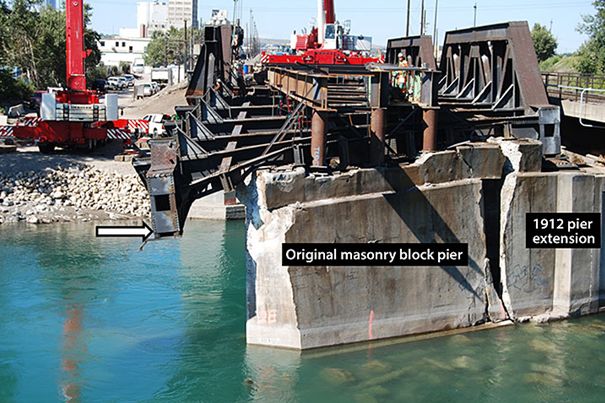
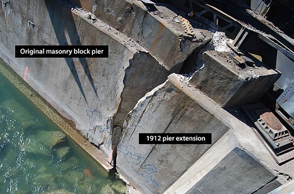
Post-accident photographs taken 04 September 2013, when the river level had subsided, show that the upstream 1912 extension had separated from the original masonry block pier (Photo 7 and Photo 8). The river bottom can also be seen in these photographs. During some of the dry months (e.g., September), the foundation of Pier no. 2 can be completely out of the water.
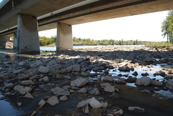
Photo 9 (taken in September 2013) shows a rock bar deposited downstream under the Ogden Road Bridge. Some of the broken-up bedrock deposited at this location had likely originated from under and around Pier no. 2 of the Bonnybrook Bridge.
Post-flood underwater inspection of Bonnybrook Bridge
Underwater inspection of Pier no. 2 of the Bonnybrook Bridge was not possible during the flood, due to the high volume and high flow rate of the silty flood water. However, on 28 June 2013 (after the accident), a bathymetric surveyFootnote 13 was conducted. This survey identified a scour hole on the downstream side of Pier no. 2. The survey images indicated that scour of more than 1 m was present downstream of Pier no. 2, and that much less scour was present around the other piers.
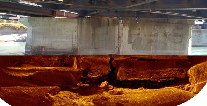
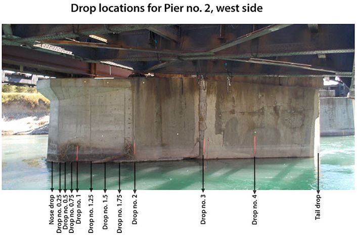
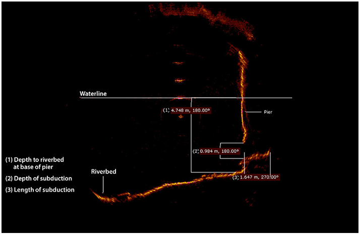
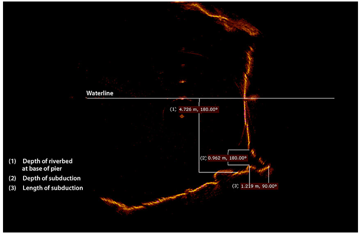
A subsequent bathymetric survey was conducted in late August 2013, when the water had cleared and the flow rate had dropped to normal levels. A sonar (acoustic) survey of the riverbed and the west side of Pier no. 2 was also performed (Photo 10 and Photo 11). A diver was also used to assess the extent of the scour. It was determined that the June flood had created a major scour hole on the west side (i.e., downstream end) of Pier no. 2 and in the river channel between Pier no. 2 and Pier no. 3.
Table 3 summarizes the results of the sonar survey at Pier no. 2. The sonar images for drop no. 2, drop no. 3, and drop no. 4 are presented in Appendix B.
| Sonar drop no. | Depth to riverbed at base of scour (m) | Depth of subduction* (m) | Length of subduction (m) |
|---|---|---|---|
| 2 | 4.748 | 0.984 | 1.647 |
| 3 | 4.726 | 0.962 | 1.219 |
| 4 | 5.026 | 1.305 | 1.112 |
* Undercut or erosion depth
The scour or undercut of Pier no. 2 ranged from 33% to 49% of the width of the 3.353-m-wide pier extension.
Emergency response following the bridge failure and derailment
Following the bridge failure and derailment, the following emergency response activities were initiated:
- CP personnel (structural, geotechnical, and engineering) conducted their initial damage assessment of the derailed cars, track, bridge, and pier, and set up the command post in Alyth Yard.
- The CP Police Communications Centre notified the Calgary Police Service at 0343 and the Calgary Fire Department at 0347.
- The city fire department (CFD) set up its command post near Alyth Yard. A unified incident command structure with CP and other responders was initiated. The CFD assumed command and control of the site, as the accident was seen as a potential threat to public health and the environment.
- After arrival of the CFD, access to the bridge was restricted, including to CP personnel. Only the CFD and the hazardous materials responders had access to the scene.
- At 0500, with concerns about the possibility of a complete collapse of the structure and the tank cars falling into the river, the city initiated an evacuation of a ½-mile (800-m) radius. As the area was primarily industrial, the evacuation order mainly affected businesses, but it also closed the nearby Deerfoot Trail (Calgary's main north–south freeway).
The train consist, which was available from the conductor, provided information on car numbers, car position, AARFootnote 14 car type, commodity, dangerous goods UN number, load/empty status, shipper, consignee, and Standard Transportation Commodity Codes. The Emergency Response Guidebook published by TC, a guidebook for first responders during the initial phase of a transportation incident involving dangerous goods or hazardous materials, was in the possession of train crew members and dangerous-goods emergency responders. The train consist identified the contents of cars 65 to 68 as NA1993, a flammable liquid n.o.s. (not otherwise specified). The 4‑digit product identification number, known as a UN or NA (North America) number, and the hazard class listed on car placards are broad and can encompass many different hydrocarbons that have similar chemical composition but different response requirements. Compressed waybills obtained from the shipper, Imperial Oil, named the product as petroleum distillate.
Neither CANUTECFootnote 15 nor CHEMTRECFootnote 16 were contacted by the CFD for information regarding the products in the derailed cars. The product in the tank cars was readily identified once the material safety data sheet (MSDS) was received from CP. The MSDS confirmed that cars 65 to 68 contained intermediate catalytic cracked distillate, commonly called natural gasoline. Determination of the concentration of hydrogen sulphide took a little longer; this information was learned when the CFD hazardous materials team contacted the product refinery lab.
Once it was determined that the bridge had stabilized, discussion between CP and city emergency responders focused on how to safely remove the cars from the bridge. The cars were removed in the following manner:
- Cars 69 and 70 were uncoupled, and the west end of train 292 was moved away from the bridge.
- The 63rd car was re-railed, and the east end of the train was moved away from the bridge, leaving 6 cars (64 to 69) coupled together (i.e., car 64 at the east end of the bridge, cars 65 to 68 on the bridge, and car 69 at the west end of the bridge, but not derailed).
- Locomotives and reacher carsFootnote 17 were coupled to the east and west ends of this group of 6 cars to act as anchors.
- The cars were tethered together in the event of total collapse of the bridge. The decision was made to unload the loaded tank cars before removing them from the bridge. The adjacent 1969 bridge was deemed by CP and by city engineers to be safe for allowing empty tank cars to be positioned on the bridge for off-loading.
- Once the plan was in place, the evacuation perimeter was reduced, and the Deerfoot Trail was opened to traffic at 1400. Off-loading of the 6 cars began at 1755 and was completed by 2330.
- Cars 67 and 68 were separated by cutting the drawbar between them. Two side-boom dozers were used to lift the ends of cars 67 and 68 that had fallen through the bridge deck. Cars 64 to 67 were then pulled eastward off the bridge. Cars 68 and 69 were pulled westward off the bridge. This operation was safely completed, with no injuries or product loss, at 0200 on 28 June.
The evacuation order was rescinded at 0215 on 28 June, and rail traffic was resumed over the remaining 1969 bridge at 0345.
Analysis
Train operation was not considered to be a causal factor in this occurrence. There was no indication that a mechanical failure on any of the rolling stock contributed to the accident. The analysis will focus on the bridge failure, bridge inspection and maintenance, bridge scour and emergency response.
The accident
As train 292 travelled eastward over the Bonnybrook Bridge, the bridge failed under the train, resulting in the derailment of 6 cars. The bridge failed due to scour, which caused the loss of foundation at Pier no. 2. The foundation failure resulted in the clean separation of the 1912 downstream concrete extension from the original masonry block pier.
The foundations of the original masonry block pier and of both the upstream and downstream 1912 concrete extensions were spread footings on river bottom shale and sandstone. Spread footings were the construction technique of the day. The majority of the pier extension foundation was on shale/sandstone bedrock, with a small portion of the downstream end of the pier extension foundation situated on a clay seam. The bridge had endured several major floods over the past century. This time, however, the intense, unprecedented flood-water flow attacked the shale/sandstone/clay pier foundation, eroding and undermining it. The bridge scour continued to the point where the 1912 downstream concrete pier extension became unsupported and separated from the original masonry pier under train 292, and fell off into the river.
The concrete extension footing, which was connected with reinforcing bars to a false footing around the original pier, likely kept the 1912 downstream concrete pier extension from falling off earlier. The lack of keying or connecting of the original masonry block pier to the 1912 upstream extension allowed the upstream extension to separate cleanly, without further damaging the 1969 bridge pier.
Pier no. 2 was founded on shale, with a small portion of the downstream end of the pier supported on clay. Although shale and sandstone are not an ideal foundation material, this material can provide a strong or competent foundation if continuous and confined. Pier no. 2 was built circa 1897 and extended in 1912, so the shale and sandstone material supporting the pier was competent and confined for over a century before the force of the flood broke it up.
Bridge inspection and maintenance
Bridges are critical pieces of a railroad's infrastructure that require frequent and comprehensive inspection and maintenance. The regular inspection and maintenance protocols of Canadian Pacific Railway's (CP's) Railway Bridge Safety Management program (RBSMP) closely reflect Transport Canada's (TC's) Guideline for Bridge Safety Management. Inspections conducted on the Bonnybrook Bridge exceeded regulatory requirements during the flood.
Routine visual inspections of the pier foundations during low water flows were conducted as part of annual inspections. During the recent visual inspections of the Bonnybrook Bridge, there was no evidence of foundation scour.
CP took measures during the flood to ensure that the bridge was stable by placing loaded cars on the deck and increasing visual inspections from ground level. Visual observations of any deviations in the rail and track alignment or surface would have indicated the gradual settlement of a bridge pier; however, they would not necessarily have provided warnings of an impending bridge failure.
Underwater inspections during the flood were not feasible due to the high volume of fast-moving, turbid water. The full extent of the scour was not determined until about 2 months after the bridge failure, when visual inspections and sonar surveys were conducted. During the flood, CP believed that train operations over the bridge were safe, as there had been no changes in the bridge geometry and the bridge had no history of foundational instability or scour.
Even prior to the occurrence, track speed was limited to 10 mph over the bridge on the 3 non-main tracks and 25 mph on the main track, P1. Less than 1.5 hours before the collapse, the bridge was safely used by a loaded potash train on track P1. Due to the extent of scour and loss of foundation support that was caused by the flood waters but was unknown to the bridge inspectors, the bridge failed.
Bridges with spread footings
Most of the CP bridges in southern Alberta, including the ones with spread footings, are decades old and have withstood major flooding in the past. Adequate protection against flood damage and washouts is essential for maintaining dependable service and avoiding the significant costs involved in replacing damaged structures and restoring operations. Placing of rip-rap is commonly used to inhibit local scour at bridge piers and abutments. If measures are not taken to inhibit local scour, especially at bridges with spread footing foundations, there is an increased risk that high-water events will lead to bridge failures.
Emergency response
When derailments involving dangerous goods occur in rural areas, CP usually takes the lead role in the emergency response. In these situations, CP personnel will have more experience and technical knowledge in dealing with the dangerous goods involved than will small rural fire departments, which are normally staffed with volunteer personnel.
The Bonnybrook incident occurred in Calgary, a major city with comprehensive emergency response resources. For this reason, the city fire department assumed overall command of the response, even though its resources were heavily deployed under the city's state of emergency due to the flood. The unified command structure initiated by the City of Calgary Fire Department worked well, including in its interaction with CP, in securing the site and in developing and executing the plan to safely remove the derailed cars from the bridge.
Findings
Findings as to causes and contributing factors
- As train 292 travelled eastward over the Bonnybrook Bridge, bridge Pier no. 2 failed under the train, resulting in the derailment of 6 cars.
- The Bonnybrook Bridge failed due to scour of the downstream end and loss of foundation support of Pier no. 2.
- Intense, unprecedented flood-water flow had attacked the shale bedrock/clay pier foundation, eroding and undermining it.
- The bridge scour continued to the point where the 1912 downstream concrete extension at Pier no. 2 became unsupported, separated from the original masonry pier under train 292, and fell off into the river.
Findings as to risk
- If measures are not taken to inhibit local scour, especially at bridges with spread footing foundations, there is an increased risk that high-water events will lead to bridge failures.
Other findings
- The regular inspection and maintenance protocols of Canadian Pacific Railway's Railway Bridge Safety Management Program closely reflect those outlined in Transport Canada's Guideline for Bridge Safety Management.
- Inspections conducted on the Bonnybrook Bridge exceeded regulatory requirements during the flood.
- Visual observations of the alignment and surface of the rail and track would normally detect deviations and gradual settlement of a bridge pier. However, such inspections would not necessarily provide warnings of a bridge failure.
- The lack of keying or connecting of the original masonry block pier to the 1912 extension allowed the upstream extension to separate cleanly, without further damaging the 1969 bridge pier.
- The unified command structure initiated by the City of Calgary Fire Department worked well in securing the site and in developing and executing the plan to safely remove the derailed cars from the bridge without incident.
Safety action
Safety action taken
On 28 June, Transport Canada (TC) issued an emergency directive to Canadian Pacific Railway (CP) under Section 33 of the Railway Safety Act. The directive ordered CP to identify the bridges located in the South Saskatchewan River Basin (SSRB), Oldman River, Bow River, and Red Deer River basins that have spread footings, and to restrict train speed over these bridges to 10 mph. Train speed over a bridge was not to be increased unless the bridge was inspected by a professional engineer or by a qualified bridge inspector under the direction of a professional engineer, and unless the bridge was determined to be safe for train operations. Within 48 hours of removal of the speed restriction, CP was requested to provide written confirmation to TC that the bridge was safe to operate over based on the assessment of the qualified bridge inspector and the determination of the professional engineer. The directive remained in effect until 28 December 2013.
In addition, TC
- issued a letter of safety concern to all federal railways to flag a concern regarding unsafe conditions at bridges and culverts as a result of flooding or high-flow events; and
- issued Railway Safety Bulletin 2013-001, which focused on scour and its effect, on examples of recent failures experienced in Canada due to heavy precipitation, and on recommended procedures and industry best practices to address the issue.
TC is updating its Guideline for Bridge Safety Management and Guideline for Culvert Safety Management. Scour, erosion, and stream stability hazards, including those associated with spread foundations, will be addressed. In June 2014, TC met with railway industry representatives to discuss the proposed revisions. The revised guidelines are expected to be finalized by December 2014. CP identified 56 bridges with spread footings that were situated within the designated river basins. Bridges at Mile 0.30 of the Brooks Subdivision and Mile 27.3 of the Macleod Subdivision had speed restrictions of 10 mph imposed due to scour and wing-wall failure, respectively. CP indicated that the repair work was completed during summer 2013. Underwater inspections and tactile inspections of the bridges at Mile 19.8 and Mile 74.9 of the Crowsnest Subdivision and Mile 51.8 of the Laggan Subdivision were conducted.
In addition, CP
- is examining what changes in policy or procedure can be implemented in an upcoming new release of its Bridge Safety Management Program (BSMP) to address scour inspections during flood events;
- is planning to increase its focus on scour inspection requirements, practices, and methods during training of its inspectors; and
- is investing in and researching technologies for early detection of scour and erosion that could be employed either permanently on certain structures or intermittently during certain events, such as floods.
This report concludes the Transportation Safety Board's investigation into this occurrence. the Board authorized the release of this report on . It was officially released on 17 December 2014.
Appendices
Appendix A – Estimated peak river flowsFootnote 18
Note: m³/sec = cubic metres per second
Bow River at Banff
2013 estimated peak flow: 439 m³/sec
2012 peak flow: 268 m³/sec
1923 peak flow: 399 m³/sec
Bow river at Calgary
2013 estimated peak flow: 1740 m³/sec (21 June 2013)
2005 peak flow: 791 m³/sec
1932 peak flow: 1520 m³/sec
Crowsnest River at Frank
2013 estimated peak flow: 133 m³/sec
1998 peak flow: 75 m³/sec
1995 peak Flow: 135 m³/sec
Elbow River at Bragg Creek
2013 estimated peak flow: 959 m³/sec
1932 peak flow: 836 m³/sec
1929 peak flow: 489 m³/sec
Oldman River at Lethbridge
2013 estimated peak flow: 2670 m³/sec
1995 peak flow: 4670 m³/sec
Red Deer River at Drumheller
2013 estimated peak flow: approximately 1300 m³/sec (near midnight on Sunday, 23 June 2013)
Sheep River at Black Diamond
2013 estimated peak flow: 720 m³/sec
2005 peak flow: 380 m³/sec
Sheep River at Okotoks
2013 estimated peak flow: over 1000 m³/sec
2005 peak flow: 769 m³/sec
South Saskatchewan River at Medicine Hat
2013 estimate peak flow: 5300 m³/sec (early morning on Monday, 24 June 2013)
