Main-track train derailment
VIA Rail Canada Inc.
Passenger train P69341-04
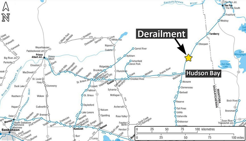
Mile 23.60, Turnberry Subdivision
Hudson Bay, Saskatchewan
The Transportation Safety Board of Canada (TSB) investigated this occurrence for the purpose of advancing transportation safety. It is not the function of the Board to assign fault or determine civil or criminal liability. This report is not created for use in the context of legal, disciplinary or other proceedings. See Ownership and use of content. Masculine pronouns and position titles may be used to signify all genders to comply with the Canadian Transportation Accident Investigation and Safety Board Act (S.C. 1989, c. 3).
The occurrence
On 04 July 2018, a VIA Rail Canada Inc. (VIA) operating crew was ordered at 2230Note de bas de page 1 in Canora, Saskatchewan, for VIA passenger train P69341-04. The train was to operate northward from Canora to Hudson Bay, Saskatchewan, on the Canadian National Railway Company (CN) Yorkton Subdivision. From there, it was to operate on the CN Turnberry Subdivision from Hudson Bay (Mile 0.0) to The Pas, Manitoba (Mile 83.4). The crew consisted of 2 locomotive engineers who were qualified for their positions, met fitness and rest requirements, and were familiar with the territory. There were also 3 on-board VIA service personnel and 16 passengers.
The train, which was powered by 2 head-end locomotives (VIA 6427 and VIA 6420), consisted of a baggage car, 4 passenger coaches, and an observation car. It weighed 623 tons and was 622 feet long.
Earlier that afternoon, the crew of a CN freight train travelling southward on the Turnberry Subdivision observed high water in the area near Otosquen, Saskatchewan (Mile 35.2).
Before the VIA train departed Canora at 2254, the CN train crew advised the VIA crew to be on the lookout for high water near Otosquen.
While operating on the Turnberry Subdivision, the VIA crew observed a number of locations with high water adjacent to the track. At 0253 on 05 July 2018, while passing Mile 17.0 of the subdivision, the VIA crew reported to the CN Rail Traffic Controller (RTC) that there was high water between Mile 14.0 and Mile 16.0 of the subdivision. At 0305, the train was proceeding at 35 mph when the crew again became concerned by the high water adjacent to the track. As a precaution, the crew began to slow the train.
At 0306, while travelling at 33 mph, the train encountered a track washout in a remote location north of Hudson Bay at Mile 23.60 of the Turnberry Subdivision (Figure 1).
The 2 locomotives derailed and came to rest on their side. The crew then made an emergency radio broadcast and advised the rail traffic controller (RTC) of the derailment and the need for assistance as the site was inaccessible by road.
At approximately 0430, CN Engineering personnel arrived by hi-rail vehicle at the derailment site. The 16 passengers and 5 crew members were evacuated from the site by hi-rail vehicle. The 2 operating crew members sustained minor injuries and were treated at the local hospital. There were no other injuries.
Site examination and equipment information
Aerial site examination revealed that the 2 locomotives and the first 2 cars had derailed and come to rest on the west side of the washed-out single main track (Figure 2). The locomotives had jackknifed, with the second locomotive partially submerged in water. The first derailed car was the baggage car, which had both trucks derailed and was leaning at approximately 40°.
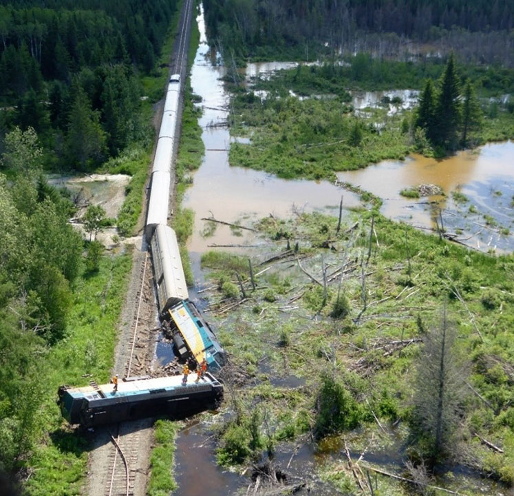
The second derailed car was a passenger coach, which came to rest upright with the lead truck derailed. The trailing 3 passenger coaches and the observation car remained upright on the track. About 800 feet of track was damaged or destroyed.
In addition to the washout location at the derailment site, there were 9 other washout locations further north on the Turnberry Subdivision.
Subdivision and track information
The Turnberry Subdivision is single main track, extending from Hudson Bay to The Pas. Train movements on the subdivision are governed by the Occupancy Control System (OCS), as authorized by the Canadian Rail Operating Rules (CROR) and supervised by a CN RTC located in Edmonton, Alberta. In the vicinity of the derailment, the maximum authorized speed for both freight trains and passenger trains was 40 mph. Train traffic consisted of about 5 trains per week.
In the vicinity of the derailment, the track was tangent with a slight descending grade to the north. The rail was 100-pound continuous welded rail, which had been installed in 1978. The rail had been secured to hardwood ties using 12-inch double-shouldered tie plates with 2 spikes per plate. The rail wear was within specified limits.
The most recent track geometry testing and ultrasonic rail flaw detection were conducted on 02 July 2018 and 16 April 2018, respectively. These tests revealed that there were no urgent or near-urgent defects within 1 mile of the derailment location.
On the afternoon of 04 July 2018, due to high water in the area that was reported by the crew of the CN southbound freight train, CN Engineering personnel were dispatched to conduct a hi-rail inspection of the subdivision. At approximately 1900, the track patrol traversed the area near Mile 23.60 and reported that all culverts were functioning as intended.
Weather information
At the time of the occurrence, the temperature was 11 °C. In the 4 days preceding the occurrence, a total of 101.5 mm of rain had fallen. On 04 July 2018, Environment and Climate Change Canada issued a rainfall warning bulletin that forecasted heavy rains from Hudson Bay to Porcupine Plain, Saskatchewan.
Water flow near Saskatchewan Highway 9
Saskatchewan Highway 9 is a 2-lane gravel secondary highway. Approximately 1 mile west of the occurrence site, Highway 9 runs adjacent to, and is located at a higher elevation than, the rail line. The highway, associated bridges, and culverts are inspected and maintained by the Province of Saskatchewan Ministry of Highways and Infrastructure.
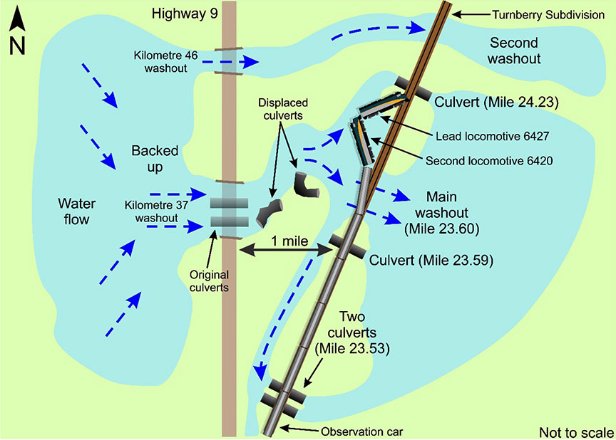
The Pasquia Hills, located west of Highway 9, are at a higher elevation than both the road and the rail line. Consequently, water in the area flows from the west to the east, first encountering the highway and then the rail line. A series of culverts and bridges are used to manage the water flow in the vicinity of the road and the rail line.
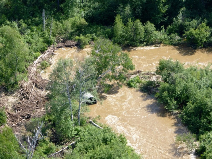
To provide drainage from the Pasquia Hills, 2 culverts, each measuring about 30 feet long by 8 feet in diameter, run from west to east under Highway 9 at roadway kilometre 37. Following heavy rains in the area in the week before the occurrence, the culverts under the highway began accumulating forest debris. This resulted in the accumulation of a significant amount of water along the west side of the highway. With the rising water levels and the associated rise in hydraulic pressure, the water flow eventually overwhelmed the culverts and washed out the highway, including the culverts. The culverts were displaced about 30 m east of the highway (Figure 3). In addition to this washout location, the highway and culverts were washed out at roadway kilometre 46 and roadway kilometre 78. A bridge at roadway kilometre 68 was also washed out.
The culverts under Highway 9 at roadway kilometre 37 had most recently been inspected in 2016 by employees of the Saskatchewan Ministry of Highways and Infrastructure. The inspection revealed that there was some damage from forest debris, but that the culverts were in good condition. In addition, 2 days before the occurrence, highway employees, who had been conducting road maintenance in the vicinity, had observed water flowing through the culverts and assumed that the culverts were functioning as intended.
On 04 July 2018, at about 0900, highway employees observed debris near the roadway culvert at kilometre 37, but water was still flowing freely through the culvert. At approximately 1600, highway employees observed that a partial washout had occurred at roadway kilometre 37 of Highway 9, but the roadway culverts were still in place. At this location, the rail line is not visible from the highway. There was no specific indication to the highway employees that the downstream railway infrastructure could be affected by the partial washout. Neither the Saskatchewan Ministry of Highways and Infrastructure nor the railways have any protocols in place to share information when nearby or adjacent infrastructure may be at risk during periods of heavy rainfall.
With the highway breached, the excess water flowed overland, flooding the railway right-of-way between 2 railway culvert locations (i.e., Mile 23.53 and Mile 24.23). The increased water volume eventually overwhelmed the railway culverts (three of which measured 3-feet in diameter and one of which measured 2 1/2 feet in diameter) and started to flow through the track subgrade. Eventually, the trackbed washed out, leaving the track unsupported at the occurrence location (Figure 4).
Other occurrences with drainage issues
Since 2009, the TSB has conducted 4 other investigations involving a main-track train derailment resulting from a subgrade failure involving various drainage issues along the railway right-of-way.Note de bas de page 2
Safety action taken
Following this occurrence, CN initiated the following safety action:
- CN's SkyGuard warning system was modified to identify weekly accumulation of precipitation and to communicate warnings when water capacity thresholds are reached for a specific area.
- When rainfall occurs over multiple days and sustained accumulation has been identified, the number of patrols in front of trains will be increased.
- When CN is informed by its weather information provider that a certain area is expected to exceed 40 mm of continuous rain or that a severe weather advisory is to be issued, CN will implement additional track patrols that will continue for 4 hours after the rain stops to monitor drainage along the railway right-of-way.
Safety message
In locations where railway and road authority infrastructure shares a common drainage basin, it is critical that the authorities have communication protocols in place for the sharing of information relating to the protection of the infrastructure.
This concludes the TSB's limited-scope investigation into this occurrence. The Board authorized the release of this investigation report on . It was officially released on .