Collision with Tower
Essential Helicopters
Bell 206B (Helicopter) C-GCHB
Elk Lake, Ontario, 7 nm SW
The Transportation Safety Board of Canada (TSB) investigated this occurrence for the purpose of advancing transportation safety. It is not the function of the Board to assign fault or determine civil or criminal liability. This report is not created for use in the context of legal, disciplinary or other proceedings. See Ownership and use of content. Masculine pronouns and position titles may be used to signify all genders to comply with the Canadian Transportation Accident Investigation and Safety Board Act (S.C. 1989, c. 3).
Summary
At 1226 Eastern Daylight Time, a commercially registered Bell 206B (registration C-GCHB, serial number 1226), operated by Essential Helicopters, departed North Bay for a visual flight rules flight to Kapuskasing, Ontario. The pilot was repositioning the helicopter for sightseeing flights planned at a local festival the next day. Another company pilot was a passenger. During the flight, poor weather conditions were encountered and approximately 1 hour and 12 minutes after departure, in the vicinity of Elk Lake, the helicopter collided with a tower approximately 79 feet in height. The helicopter then struck the ground approximately 430 feet beyond the tower, and was destroyed. Both occupants were fatally injured; there was no post-impact fire. The emergency locator transmitter functioned but its range was reduced significantly as its antenna was sheared on impact.
Factual Information
Sequence of Events
At 1046, Footnote 1 the pilot telephoned the London Flight Information Center (FIC) to acquire weather information. At the same time, the passenger reviewed the weather conditions on the NAV CANADA website. The pilot and the passenger separately briefed senior personnel from Essential Helicopters regarding the weather conditions. Based on the information provided by the pilot and passenger, company senior personnel agreed that the weather was suitable for the intended flight.
The helicopter departed North Bay at 1226, and reported clearing the control zone on the North Bay mandatory frequency (MF), after which there was no known communication with air traffic services (ATS).
Two hand-held global positioning system (GPS) devices were on board and data from one was recovered. According to the GPS data, the helicopter reached a maximum altitude of approximately 2300 feet above sea level (asl), 20 nautical miles (nm) from North Bay. Shortly afterwards the helicopter began to descend, and for the remainder of the flight the altitude ranged between approximately 1550 feet asl and 1950 feet asl.
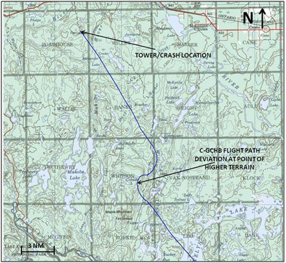
At about 1327, approximately 17 nm prior to the occurrence location, the helicopter encountered an area of higher terrain, and slowed from 102 knots to 89 knots, Footnote 2 and climbed from about 1600 feet asl to about 1725 feet asl. Shortly afterwards, a right turn to the northeast was commenced and the helicopter further slowed to 84 knots (see Figure 1). Because of the higher terrain, the helicopter's height was reduced to about 185 feet above ground level (agl). As it continued northeast, the terrain elevation became lower, increasing the helicopter's height above ground to as much as 800 feet agl. The helicopter turned to the northwest and continued toward Kapuskasing. Over the next 7 minutes, its altitude ranged from 1640 feet asl to 1860 feet asl, averaging about 1740 feet asl; and the ground elevation varied from about 300 feet asl to 720 feet asl.
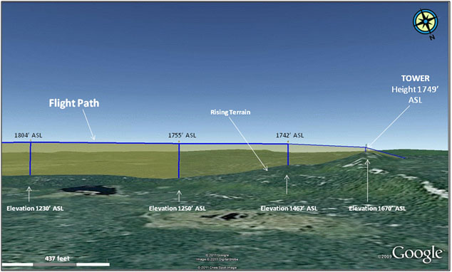
The second last GPS position prior to the crash placed the helicopter approximately 2600 feet southeast of the tower at an altitude of 1755 feet asl (500 feet agl). The last GPS position placed the helicopter about 1000 feet from the tower at an altitude of 1742 feet asl (275 feet agl); the speed was 104 knots.
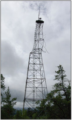
At 1338, while flying in a northwest direction, the helicopter struck the tower, at a point approximately 2⁄3 of its height, and subsequently crashed into the terrain below. There was no post-impact fire. Both occupants were wearing helmets at the time of the accident.
Following the crash, emergency services were notified and, approximately 1 hour later, attended the scene via a logging road.
Wreckage
The damage sustained by both the helicopter and tower were consistent with a frontal impact with significant velocity. The helicopter sustained substantial structural damage during impact and began shedding major structural components prior to ground impact, including parts from the forward section of the fuselage, rotor blades and main rotor transmission. Consequently, there was a large debris field. The wreckage trail began at the base of the tower and continued 138 feet past the main fuselage. The entire debris field was approximately 568 feet in length.
The emergency locator transmitter (ELT) activated. However, because of the severe impact forces, it had separated from the antenna which diminished the signal. Numerous flight instruments had separated from the instrument panel and were found in the wreckage trail, but no useful information was obtained from them.
The 2 portable GPS units were found in the wreckage trail, 1 of which (Garmin GPSMAP 96C) was sent to the TSB Laboratory, where the occurrence flight data were successfully extracted. Also, 2 Sault Ste. Marie Visual Navigation Charts (VNC) Footnote 3 were located in the wreckage trail, one of which was the current edition (edition 22, effective November 2009), and the other, an older edition (edition 20, effective February 2006). Both charts were unfolded, and severly damaged, indicating they were likely being used at the time of the occurrence.
The helicopter systems were examined to the extent possible, and no indication of a malfunction was found. Records indicated the aircraft was certified, equipped, and maintained in accordance with existing regulations and approved procedures.
Tower/ Occurrence Location
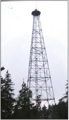
The tower was owned by the Ontario Ministry of Natural Resources (OMNR). It was constructed from steel and was built several decades ago for forest fire detection (see Photo 1 and Photo 2). At the time of the occurrence, the tower was used as a radio communications tower, and was leased to a logging company. It was grey in colour and not lighted or painted with visible markings. The tower was approximately 79 feet in height, and was located on top of a hill, with a ground elevation of about 1670 feet asl.
Steel fire towers were built between 1943 and 1962. Approximately 320 towers were erected throughout Ontario. It could not be determined what the obstacle reporting requirements (height and location) were at the time of construction. Aircrafts took over the fire detection function of the towers in the 1970s and the towers are no longer manned. The height of the towers ranged from 60 feet agl to 100 feet agl. Although OMNR is aware of the locations of the remaining fire towers, it is not known how many of those are still standing.
Weather and Environment
When the London FIC was called, the pilot requested the current aviation routine weather reports (METARs) for North Bay (elevation 1215 feet asl), Timmins (elevation 967 feet asl) and Kapuskasing (elevation 743 feet asl), and the forecast for the next couple of hours at the same locations. The flight service specialist (FSS) provided the 1000 METARs and a verbal summary of the aerodrome forecasts (TAFs) for the above locations. The METARs indicated the lowest ceiling as 7000 feet agl, and lowest visibility as 15 statute miles (sm). The TAFs indicated the lowest ceilings as 2000 feet agl, both of which were above the weather minima required for VFR flight.
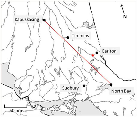
Weather information for other airports located near the route of flight, such as Sudbury (elevation 1140 feet asl, located 42 nm west of the intended track) or Earlton (elevation 800 feet asl, located 21 nm east the intended track) (see Figure 2), and the graphical area forecast (GFA) were not obtained during the telephone call. The pilot did not request a pilot weather briefing or any notice to airman (NOTAM) information. According to the flight service (FS) Manual of Operations (MANOPS) the definition of a pilot briefing at the time of the occurrence was “the provision of, or consultation on, meteorological and aeronautical information to assist pilots in preflight planning”
. Section 301.2 of FS MANOPS requires the FSS to offer a pilot briefing if a pilot only requests specific briefing information or only files a flight plan. However, the FSS did not offer the pilot briefing.
The 1000 METAR for Sudbury indicated a visibility of 2 1⁄2 sm in light rain and an overcast ceiling of 400 feet agl; in remarks the ceiling was described as ragged. At 1016, the Sudbury weather indicated a visibility of 1 sm in light drizzle and mist with an overcast ceiling of 500 feet agl; in remarks the ceiling was described as ragged. Both of these reports were available at the time of the pilot's call to the FS, but there was no indication they were checked.
The Sudbury TAF, issued at 0938, indicated a visibility of 2 sm in light rain and mist with a broken ceiling of 500 feet agl. After 1200, the TAF indicated a visibility of at least 6 sm and an overcast ceiling of 3000 feet agl, with a temporary condition (1200 to 1400) of visibility 2 sm and a broken ceiling at 800 feet agl. The Sudbury TAF was amended at 1228, valid from 1200 and indicated a visibility of 2 sm in light rain and mist with a broken ceiling of 300 feet agl.
The 1000 METAR for Earlton indicated a visibility of 7 sm in light rain and an overcast ceiling of 2000 feet agl. At 1037, a special weather report (SPECI) indicated a visibility of 9 sm in light rain, and an overcast ceiling of 700 feet agl.
The Earlton amended TAF, issued at 0915, indicated a visibility of greater than 6 sm in light rain and a broken ceiling of 1500 feet agl after 1100. At 1052, the TAF was amended again and indicated a temporary condition (1000 to 1400) of 6 sm in light rain and ceiling of 700 feet agl (1500 feet asl).
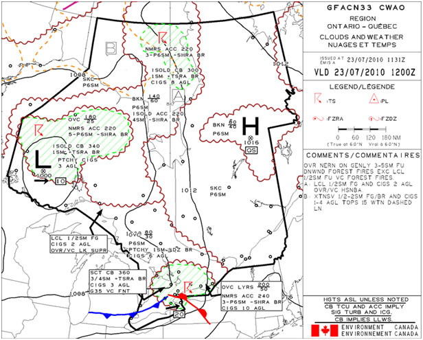
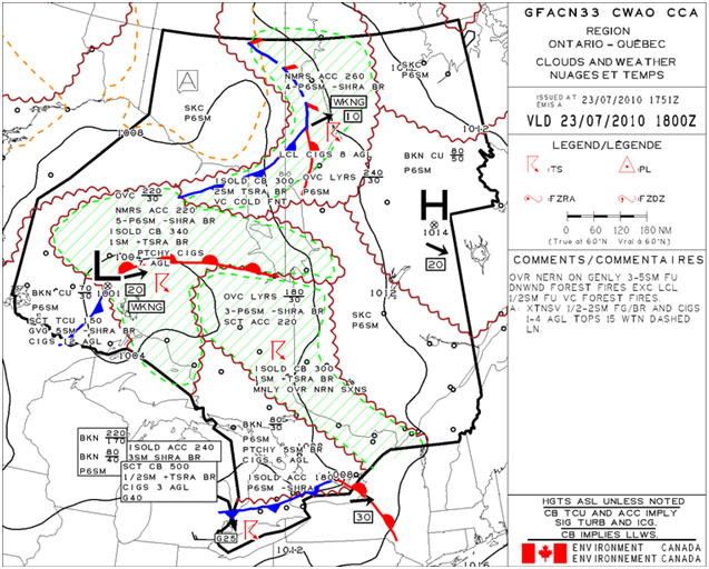
In the vicinity of the helicopter's intended flight path (see Figure 2), the GFA issued at 0731, valid from 0800, indicated an overcast ceiling at 3000 feet agl and visibility greater than 6 sm with patchy visibility of 1 sm to 3 sm in drizzle and mist and a ceiling at 600 feet agl. The GFA issued at 1351, valid from 1400, indicated isolated cumulonimbus cloud (CB) topped at 30 000 feet with 1 sm visibility in heavy thunderstorm, rain and mist (see Appendix A).
It could not be determined what locations and types of reports the passenger checked while using the NAV CANADA website or if the NOTAM information was checked. However the passenger reported that VFR conditions were present and expected for the flight.
At the time of the accident, low ceilings and poor visibility were present at the occurrence location, low enough that the tower would have been obscured at times. The Earlton METAR, issued 15 minutes after the accident, indicated the visibility as 2 1⁄2 miles in light rain with a broken ceiling of 500 feet agl (1300 feet asl).
Another helicopter flying in the vicinity of the occurrence at approximately 1130 encountered poor weather conditions. Approximately 1 hour after the occurrence, the visibility and ceilings were such that the tower was not visible until approximately 1⁄4 to 1⁄2 mile from the structure.
Route Topography
For a good portion of the occurrence helicopter's flight, the ground elevation was similar to that of North Bay (1160 feet asl). The ground elevation along the helicopter's flight path for the 3 nm prior to the tower was around 1050 feet asl, gradually increasing to about 1470 feet asl just prior to the tower, and finally 1670 feet asl at the tower location (see Figure 3). The elevation decreased again past the tower.
The maximum elevation figure (MEF) depicted on the VNC, for the quadrant where the tower was located was 2300 feet asl. The MEF indicates the highest terrain elevation plus 328 feet (100 meters) or the highest known obstruction elevation. Therefore, an aircraft operating above the MEF should be above all known obstacles in that particular quadrant.
The MEF provides advisory information regarding the highest terrain/obstacle in that sector. The flight was operating in uncontrolled airspace, and there were no regulations, or company directives preventing the pilot from flying below the MEF. Both rotary and fixed wing aircraft routinely fly below the MEF but still at a safe height above ground.
NAV CANADA Charts
On 01 January 2007, NAV CANADA assumed responsibility from Natural Resources Canada (NRCAN) for the production, printing and amendment of Aeronautical Information Publications, including the VNC. NAV CANADA produced editions 21 and 22 of the VNC while edition 20 was produced by NRCAN. The route of the helicopter's flight from departure to the occurrence location was in the area of the Sault Ste. Marie VNC. The tower has never been depicted on this VNC, going as far back as 1985. However, a fire tower is depicted at that location on topographical maps.
Furthermore, the NAV CANADA database has no data to suggest that a fire tower or any other obstacle existed at that location. According to NAV CANADA there have been no obstructions/towers change requests since the transition from NRCAN. The tower was not mentioned in any NOTAM on the day of the occurrence nor was it in the VFR chart updating section of the Canada Flight Supplement (CFS).
The Transport Canada (TC) Aeronautical Information Manual (AIM) states the following:
At present, individual charts in each series are reviewed such that for charts covering the more densely populated areas, the topographic base maps are examined every 2 years and the aeronautical information is reviewed once a year. For areas outside the more densely populated areas, the topographic base maps are reviewed every 5 or 6 years and the aeronautical overlays are reviewed every 2 or 5 years, depending on the location in Canada. Charts identified as requiring updating during these inspections are then revised and reproduced.Footnote 4
NAV CANADA maintains that the 1:500,000 scale of the VNC does not allow for the inclusion of smaller obstacles, such as these fire towers, as the number of obstacles would obscure the readability of the chart over large areas. Instead, the maximum elevation figure (MEF) had been incorporated into the chart.
GPS Data
The Garmin GPSMAP 96C is a portable aviation GPS with a moving map feature. Garmin uses a combination of government and private sector sources for its data. A warning in its user guides states, “When navigating in an aircraft, use the GPSMAP 96/96C only as an aid for VFR navigation. Use terrain and obstacle data only as aid to situational awareness.”
Furthermore the user guide states, “That virtually all data sources contain inaccurate or incomplete data to some extent.”
The Garmin GPSMAP 96C has an option for the user to select an obstacle alert message. In this specific unit the alert feature was turned on, and set for obstacles located 1000 feet agl and below, 120 seconds ahead of the helicopter. However the tower was not depicted on the moving map display of the Garmin GPSMAP 96C unit, likely because the aviation maps in Canada do not depict the tower. Also its database had expired and was only valid until 13 March 2008. Garmin provides database updates every 28 days but it is up to the user to obtain them.
Transport Canada
According to the AIM, all known objects 300 feet or more agl (or lower ones if deemed hazardous) are depicted on VNCs. The AIM also states that, because there is only limited knowledge over the erection of man-made objects, there can be no guarantee that all such structures are known and, accordingly, an additional risk is added to the already hazardous practice of low flying.
The Canadian Aviation Regulation (CARs) rule 601.19 states that where it is likely that a building, structure or object, including an object of natural growth, is hazardous to aviation safety because of its height and location, the Minister may, by order, direct the owner, or other person in possession or control of the building, structure or object, to mark it and light it in accordance with the standards specified in the Standards Obstruction Markings Manual (TP 382E).
According to subsection 1.2.1 of the CARs Standard 621.19 ‑ Standards Obstruction Markings, it is the responsibility of the Minister to assess individual obstructions, namely buildings, structures or objects, to determine if they are likely to constitute a hazard to air navigation and consequently require marking and/or lighting in accordance with the standards identified as such in this publication. Subsection 1.2.2 states that persons planning to erect an obstruction should contact the appropriate regional Civil Aviation authority, as early as possible and provide specified information on the planned obstruction, using the Aeronautical Obstruction Clearance Form.
Section 2.2 of Standard 621.19 outlines the TC recommendations for obstruction marking including at which height obstructions should be marked and or lighted. According to the document, any obstruction greater than 300 feet agl, within 2 nm of the imaginary centre line of a recognised VFR route, any obstructions greater than 500 agl, and any other obstruction to air navigation that is assessed as a likely hazard to aviation safety should be marked and/or lighted in accordance with the standards.
TC uses aeronautical evaluations to determine, for the purposes of section 2.2, whether or not it is likely that an obstruction to air navigation is a likely hazard to aviation safety. There is nothing to suggest that an aeronautical evaluation was performed by TC on the occurrence tower, or any fire tower, nor were there any obstruction clearance forms on file. However, according to TC, these types of towers are deemed as not significant obstructions, likely because they were below the 300 foot mark.
Pilot
Records indicate that the pilot was certified and qualified for the flight in accordance with existing regulations. The pilot recently graduated from the Essential Helicopters flight training program where he obtained a commercial helicopter pilot's license and was subsequently employed by the operator.
According to records the pilot accumulated approximately 124 hours total flight time and 51 hours on the occurrence type helicopter. In the week prior to the accident the pilot flew 5 flights totalling 6.8 hours. The occurrence flight was the pilot's first non-training flight as an employee with the company. The pilot was not rated for instrument flight.
Essential Helicopters
Essential Helicopters is a flight training unit, and in addition, holds a valid air operator certificate under Subparts 702/703 of the CARs. At the time of the occurrence, the company operated 2 Hughes 269 and 1 Bell 206B helicopters.
The Essential Helicopters operations manual (OM) states,
“The pilot-in-command (PIC) shall be responsible for the operation and safety of the aircraft that he/she commands and for the safety of all persons onboard during flight time. For this purpose he/she will have final authority for the disposition of the aircraft during the time in which he/she is in command.”
The OM also states the following:
- Before a flight, the PIC shall:
- Familiarize himself/herself thoroughly on the basis of the latest available information with:
- The planned route, all applicable NOTAMs where available and he/she shall complete an operational flight plan and/or flight plan/flight itinerary as applicable;
- The aerodromes planned for normal or emergency use;
- The reported and forecast winds for the route;
- The reported and forecast meteorological conditions for the route, destination and alternate aerodromes or landing sites; and
- The navigation and radio aids to be used (if available).
According to the company, the pilot was trained to operate the helicopter in reduced visibility conditions. This training provided increased awareness of the reaction time required to avoid obstacles during poor visibility conditions, and emphasized the importance of executing a precautionary landing to wait for improving weather. However this training was not documented in any available flight training records.
For helicopters operating under visual flight rules (VFR) in uncontrolled airspace below 1000 feet agl, the weather limitations are flight visibility of not less than 1 mile and clear of cloud (CARs 602.115). The minimum weather limitations for VFR flight at Essential Helicopters mirror the TC regulations.
The following TSB Laboratory report was completed:
- LP 110/2010 – GPS Download
This report is available from the Transportation Safety Board of Canada upon request.
Analysis
The pilot called London FIC and obtained the weather conditions for North Bay, Timmins and Kapuskasing, all of which reported VFR weather conditions. However, the pilot did not obtain any weather reports or forecast from other stations located near the flight path, such as Sudbury and Earlton, which reported worse weather. Nor did he request the GFA or a pilot weather briefing, both of which would have given the pilot more detailed information of the weather conditions along the route of flight. Therefore, he was not fully aware of the weather conditions, and consequently briefed the senior company personnel that the weather was suitable for the flight.
The flight service specialist did not offer a pilot briefing, which is required by the FS MANOPS. Had the pilot received all of the available weather information, it might have affected his decision to depart.
All of the METARs were reporting conditions above the minimum required for VFR flight in uncontrolled airspace. However, the elevation at the occurrence site is higher than all of the stations reporting the METARs. Consequently, if the cloud base at the occurrence location was at a similar height to that of the reporting stations, the cloud base above ground would have been reduced. This was confirmed by the actual weather conditions at the occurrence site at the time. There was no data to indicate that this was considered a factor during the flight planning stage.
The helicopter was travelling at a normal cruise speed (104 knots) about 1000 feet from the tower, and the damage sustained by both the helicopter and tower were indicative of a frontal impact with significant velocity. The GPS data did not indicate any sudden manoeuvring. The velocity and course appeared constant, implying the pilot did not see the tower with enough time to react prior to impact, likely because the tower was obscured by the weather, or blended into the overcast conditions.
About 17 nm prior to the occurrence location, the pilot had deviated from the intended flight path, and reduced the helicopter's speed, likely due to higher terrain and weather conditions. However, shortly afterwards, cruise speed was re-attained, which decreased the time the pilot had to react prior to tower impact.
The pilot was likely navigating using the VNC or GPS. However, because the tower was not depicted on the VNC or GPS, the pilot was not likely aware that it existed. The visibility was reduced. The tower was grey coloured, not marked or lit, and may have blended into the overcast conditions, making it difficult to notice. Had the tower been marked on the VNC, the pilot might have noticed the tower depiction in time to deviate or take other corrective action.
The GPS database was not updated. As a result, there was a risk that known depicted obstructions would not have been displayed.
VNC do not depict small obstacles such as the occurrence tower. The tower did not meet the height requirements to be lighted and marked, or meet the 300 foot mark to be deemed a significant hazard. VNC depict the MEF to provide information to pilots so they can avoid terrain and obstacles. Pilots who fly below the MEF and close to the ground are at risk of encountering uncharted obstacles.
Findings
Findings as to causes and contributing factors
- The pilot did not adequately review the weather for the intended route prior to departure from North Bay. In addition, the flight service specialist did not offer a weather briefing as per the Manual of Operations (MANOPS). As a result, the pilot was not aware that poor or deteriorating weather conditions existed.
- Due to the deteriorating weather conditions, the pilot flew the helicopter at a low altitude. Reduced visibility likely obscured the tower and reduced the available reaction time the pilot had to avoid the tower.
- Because the tower was not depicted on the VNC or GPS, the pilot was not likely aware that it existed.
- The GPS database was not updated. As a result, there was a risk that known depicted obstructions would not have been displayed.
- Pilots who fly below the maximum elevation figure (MEF), and close to the ground, are at risk of encountering uncharted obstacles.
Safety action
Safety action taken
On August 25, 2011, NAV CANADA published an Aeronautical Information Circular (AIC) entitled “VNC Charts - Clarification of the Maximum Elevation Figure”
. The AIC contains the following text:
The MEF is depicted in thousands and hundreds of feet above sea level. The MEF represents the highest feature in each quadrangle. Flight at or below the MEF may be at or below the highest obstruction in that quadrangle. Pilots need to provide a margin for ground and obstacle clearance and for altimeter error. Please see AIM RAC 5.4 602.15 2b (NOTE) and AIM AIR 1.5 for detail. The MEF is calculated based on terrain data and known and unknown obstacles. In addition, the AIC describes how the MEF is calculated and states the equation used to complete the calculation.
This report concludes the Transportation Safety Board's investigation into this occurrence. Consequently, the Board authorized the release of this report on .
