Grounding
Small Passenger Vessel Le Survenant III
Sorel, Quebec
The Transportation Safety Board of Canada (TSB) investigated this occurrence for the purpose of advancing transportation safety. It is not the function of the Board to assign fault or determine civil or criminal liability. This report is not created for use in the context of legal, disciplinary or other proceedings. See Ownership and use of content. Masculine pronouns and position titles may be used to signify all genders to comply with the Canadian Transportation Accident Investigation and Safety Board Act (S.C. 1989, c. 3).
Summary
On the afternoon of 09 July 2010, the small passenger vessel Le Survenant III sailed from its home port on the Chenal du Moine, east of Sorel, Quebec, with 49 passengers and crew for a 90-minute tour of the Sorel Islands. On the return leg of the voyage, the vessel encountered a heavy squall and, in near-zero visibility, grounded near the mouth of the Chenal des Raisins at 1435 Eastern Daylight Time. No one was injured, nor was there any damage to the vessel.
Factual information
Particulars of the vessel
| Name of Vessel | Le Survenant III |
|---|---|
| Official Number | 331753 |
| Port of Registry | Sorel, Quebec |
| Flag | Canada |
| Type | Passenger |
| Gross Tonnage | 104.75 |
| LengthFootnote 1 | 18.96 m |
| Draught | Forward: 1 m Aft: 1.68 m |
| Built | 1974 |
| Propulsion | Two 141 kW diesel engines |
| Passengers | 44 (maximum capacity of 188) |
| Crew | 4 crew and 1 company representative |
| Registered Owner/Manager | Les Croisières Richelieu, Inc. |
Description of the vessel
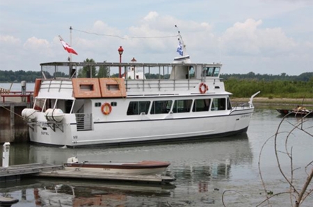
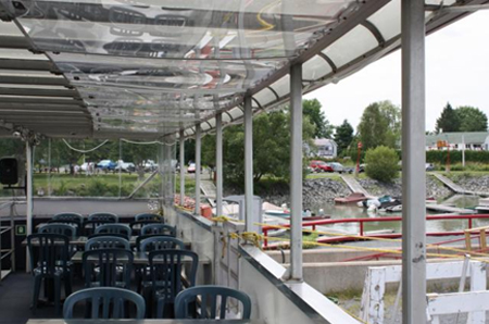
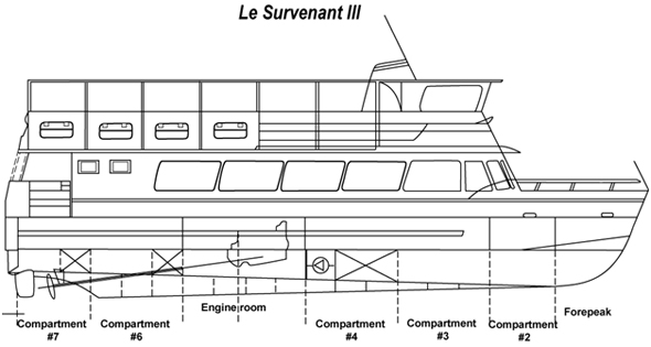
Le Survenant III is a small, 2-deck passenger vessel of closed welded aluminum construction with a transom stern (see Photo 1 and Appendix B). The navigation bridge is located at the forward end of the upper deck. The upper deck windows are hinged to swing down in case of inclement weather (see Photo 2) and are not weathertight. The vessel is powered by twin diesel engines, with twin screws and rudders. The vessel is also equipped with 2 anchors at the bow.
The vessel, berthed in the Chenal du Moine, is used for daytime sightseeing from June to September and operates around the Port of Sorel and the Sorel Islands on the western end of Lac Saint-Pierre, Quebec.
The vessel carried the required navigational equipment; a magnetic compass and a depth sounder. As a vessel restricted to daytime operations, Le Survenant III was not required by regulation to be equipped with a radar.
History of the voyage
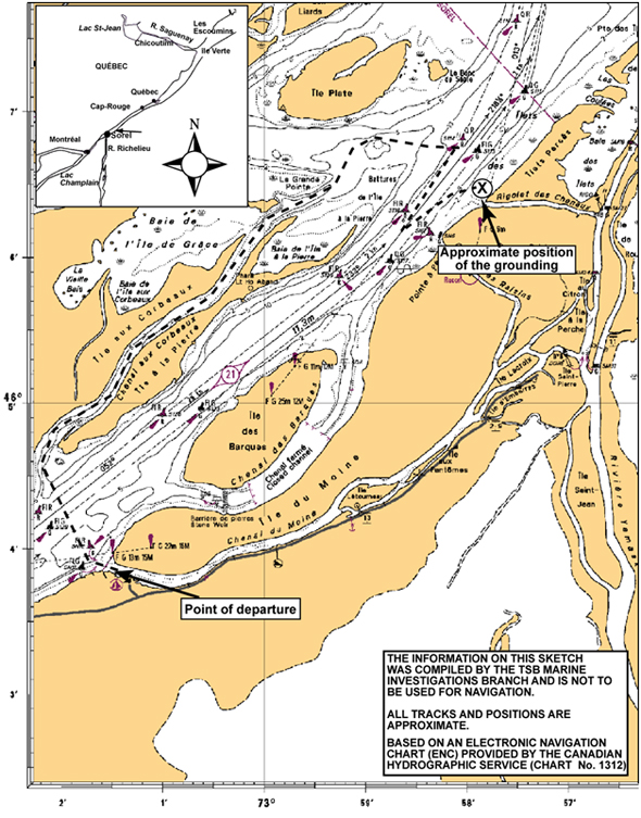
On 09 July 2010 at 1030,Footnote 2 the crew of Le Survenant III, which consisted of a master, a first officer (1/O), a deckhand and a tour guide, arrived and began to prepare the vessel for the day's first voyage - a 90-minute tour of the Sorel Islands (see Appendix A) - which was to depart at 1330. As part of his pre-departure duties, the 1/O called Marine Communications and Traffic Services (MCTS) Québec, to request information on the water level of the St. Lawrence River and Lac Saint-Pierre. This information was given to the master, who determined the route for that day.Footnote 3 As was customary, no weather information was obtained prior to commencement of the voyage.
The passengers began to arrive around noon, and purchased their tickets from an office adjacent to the dock. Around 1320, the passengers, 44 in total,boarded the vessel via the gangway that led to the upper deck, where they were met by the tour guide. A representative of the vessel's owner also boarded the vessel.
At the time of departure the sky was darkening in the west. Once the last passenger was aboard, a final passenger count was performed. The count was confirmed with the ticket office and recorded in the bridge log book. The master then provided a safety briefing.
At 1335, the master advised MCTS Québec that the vessel had just departed for the Sorel Islands. This was done on very high frequency (VHF) radiotelephone channel 13, which was the area's designated traffic frequency. At that time, MCTS Québec informed the master, who was not previously aware of the warning, that the following squallFootnote 4 warning was in effect for the area:
A squall warning is in effect from Montréal to Trois-Rivières between 1320 and 1450 local time. A cold front is moving slowly through the St. Lawrence valley toward the river, with strong thundershowers developing in the afternoon and early evening ahead of the front. Winds gusting up to 35 knots and more, with visibility of less than 1 nautical mile during the thundershowers. [Translation]
The master acknowledged receipt of this information, and continued with the voyage as planned - both the master and the 1/O anticipated that they had sufficient time to complete the cruise before the arrival of the squall. At 1355, the vessel entered the Chenal aux Corbeaux heading downriver in a north-easterly direction. At 1410, MCTS Québec again issued the general safety message to all vessels regarding the squall warning in effect, on VHF channel 13.
At 1415, after exiting the Chenal aux Corbeaux in the vicinity of buoy S-114, the master altered course to a southwesterly direction. The bridge team could see the approaching weather system to the southwest, and the master increased speed to hasten their return before the arrival of the squall. The master also advised MCTS that the vessel was proceeding upbound in the main navigation channel. MCTS informed the master that there was no traffic in the area. The master aboard the ferry Lucien L, operating approximately 7 miles to the west between Sorel and Île Saint-Ignace, overheard the conversation with MCTS and called Le Survenant III at 1422 to report that on-scene weather conditions were zero visibility with winds between 45 and 55 knots.
At 1425, the Le Survenant III encountered increasing winds and rain. In a position near buoy S-116, the master initially turned the vessel so as to place it in the centre of the navigable channel heading upstream, before eventually turning around and heading down river, away from the heavy rain and wind.Footnote 5 The master advised the 1/O to keep a constant lookout on the buoy S-116; however, as the rain and wind intensified, the 1/O lost sight of the buoy.
Unaware of the vessel's position relative to the buoy, the master stopped the engines. The vessel drifted for a few minutes until, at 1435, while still in the squall, it grounded in mud at the entrance to Rigolet des Chenaux, in position 46° 06′ 24″ N, 072° 57′ 58″ W.
After unsuccessfully attempting to refloat the vessel using the ship's propulsion, the master informed MCTS that Le Survenant III required tug assistance. At approximately 1500, the master informed passengers of the situation.
Following the grounding, the 1/O conducted a survey of the vessel and found no damage or water ingress. At 1546, the tug Duga arrived on scene. The masters from both vessels, along with an inspector from Transport Canada (TC), discussed refloating arrangements and, at 1705, the vessel was refloated. At 1800, Le Survenant III, escorted by the Duga, returned to its berth at Chenal du Moine. After the passengers had disembarked, the 1/O examined the vessel and found no ingress of water. A TC inspector came aboard later that evening and, following an inspection, cleared the vessel to return to service at 2025.
Weather and Current
On 09 July 2010 at 0300, Environment Canada issued a weather forecast for the Montréal to Trois-Rivières area, calling for strong winds and poor visibility in showers beginning around noon. At 0512, a squall watch was issuedFootnote 6 for the same area; this called for winds up to 35 knots. Further weather bulletins were issued at 1033 and 1224, and these were also available on the MCTS continuous-broadcast channel. At 1326, MCTS Montréal began broadcasting a safety message concerning a squall warning on the VHF channel 13, the working channel. At 1329, MCTS Québec began broadcasting the warning.
At the time of the occurrence, the weather conditions observed on board the vessel were estimated as follows: winds at 45 to 55 knots, heavy rain and near-zero visibility.
A weather buoy on Lac Saint-Pierre recorded weather for that date and showed that, between 1400 and 1420, wind increased from NE at 4 knots to NW at 26 knots. The maximum recorded gust was W at 52 knots, at 1440.
The current in the St. Lawrence River was approximately 2 knots in the downstream direction.
Vessel certification
The vessel is registered as a passenger vessel, and had been issued an inspection certificate and a Minimum Safe Manning Document. These were valid until 15 October 2010 and 26 May 2013, respectively. The Minimum Safe Manning Document lists the vessel as a day vessel. For a passenger complement up to 120, the vessel required a minimum of 1 master, 1 chief officer, and 1 seaman. For a passenger complement greater than 120, the vessel requires an extra seaman. The inspection certificate limits the number of passengers to 188.
The vessel also carried a valid Radio Inspection Certificate, issued by TC on 28 May 2008.
Personnel Experience and Certification
The master had approximately 44 years of experience on commercial vessels, the majority of which was on ferries in and around Sorel, Quebec. He held a valid Master Minor Waters certificate, and had served as master on Le Survenant III since 2007.
The 1/O had 4 seasons' experience, all with this company, though this was his first season as 1/O. He held a Chief Mate Limited Certificate for a vessel of 60 gross tonnage or more. He also held a Small Vessel Machinery Operator (Restricted) (SVMO-R) certificate.
The deckhand held a Limited Master Certificate and a Fishing Master IV Certificate, neither of which was required for this position. The deckhand had completed Marine Emergency Duties (MED) training, which was the only requirement.
This was the tour guide's first year working on board a ship. He held no marine certificate, nor was this required by regulation.
Lifesaving equipment
The vessel carried all required lifesaving equipment including two 75-person liferafts,Footnote 7 and 192 adult- and 20 children-sized lifejackets. The vessel also carried four 20-person buoyancy apparatuses (floating platforms) which were no longer part of the official lifesaving appliances.
The starboard liferaft canister was secured with packing straps. To prevent these straps from being cut inadvertently, they were covered with cellophane tape, on which were pictograms of a red "X" across black scissors. The scissors could be easily seen, but the "X" had faded and was almost invisible.
Voyage Planning
Prior to departure and as part of the planning phase, the master had the 1/O verify water levels in the river and on Lac Saint-Pierre. Using this information, he decided on each day's route. As that year's water level was unusually low, there had been changes to the vessel's normal routes. These had prompted passenger complaints, and so a company representative was onboard to observe operations.
This voyage was scheduled to return at approximately 1500. A second voyage was scheduled to depart at 1530 the same day.
Operational Procedures
The vessel had 2 evacuation plans on board; 1 for when carrying up to 120 passengers, the other for up to 188. There was also a lifesaving equipment plan for the vessel. The 3 plans had been approved by TC.
The vessel also had a pre-departure checklist addressing lifesaving equipment such as flares, lifejackets, and life rings.
Analysis
Voyage Preparation
Prior to getting underway, a crew must perform a number of measures to ensure the safety of the vessel and its passengers. This may include the testing of propulsion and steering, ensuring that the navigational equipment is in working order, and that the latest local weather forecast has been obtained.
In particular, the weather forecast is a critical element to be considered since weather can have a significant impact on the time required or even the ability to complete a trip. The importance of the weather and its possible effects on visibility was especially relevant in the case of Le Survenant III as the vessel was not fitted with any electronic navigational equipment for navigating in restricted visibility.
As part of the preparations for the voyage in this occurrence, the 1/O requested the water levels in the river from MCTS Québec. However, he did not obtain any weather forecast, nor was it the practice on board to do so. Therefore, the decision to sail depended entirely on the weather observed locally at the time of departure.
On the day of the occurrence, the initial squall watch was upgraded to a squall warning just prior to the vessel's departure. However, given that it was not the practice to take weather forecasts into consideration, nor was this a part of the pre-departure checklist, the crew only became aware of the warning once the vessel had departed from the dock.
Decision to Sail
The master did not become aware of the squall warning until after the vessel had departed its berth. The master received the weather information and made the decision to continue the voyage, believing that there was sufficient time to return to Chenal du Moine before the arrival of the squall.
The voyage, which was to last 90 minutes, would have been completed by about 1500. Although the squall warning was in effect from 1320 to 1450, the description of the associated cold front given to the master was that it was slow moving with strong thundershowers developing in the afternoon and early evening ahead of the front. In the absence of any other information about the impending adverse weather, the master's decision to continue with the voyage was likely based on the impression that the passage of the cold front would be later that afternoon, after their return to the berth.
Decision Making in Reduced Visibility
Knowing where you are at all times is essential to the safety of the vessel and the persons on board. This is especially important when operating in confined waters and in reduced visibility.
Le Survenant III was not fitted with any electronic navigational equipment other than the depth sounder. As a result, the practice on board was to navigate visually. In this occurrence, the vessel was caught in a squall, and visibility was significantly reduced. Upon encountering the squall, the master had an aid to navigation in sight (buoy S-116). However, he turned the vessel about, heading downstream away from the buoy and eventually losing sight of it, at which time he stopped the engines and drifted.The vessel later went aground.
While it would have been preferable to have found a suitable place to anchor prior to the arrival of the squall, several alternatives were available to the master once he was no longer able to navigate visually, which may have offered a better chance of avoiding the grounding:
- Maintain the vessel's position within sight of the buoy by using helm and engines.
- Exit the navigational channel, assisted by the echo sounder, and drop anchor.
- Anchor in the navigational channel (advising MCTS and taking other appropriate precautions against conflicting traffic).
- Heave to by reducing speed, and use the magnetic compass to maintain a heading into the wind.
Unaware of the vessel's position, the master decided to stop the engines, allowing the vessel to drift downstream, which resulted in the grounding.
Findings
Findings as to causes and contributing factors
- A weather forecast was not obtained prior to departure so the vessel proceeded into adverse weather conditions.
- The master became aware of the squall warning after departure and, assuming the voyage would be completed before the arrival of the adverse weather, continued the voyage.
- Following the onset of the squall, and unaware of the vessel's position, the master decided to stop the engines, allowing the vessel to drift downstream, which resulted in the grounding.
Findings as to risk
- Warnings or operating instructions on lifesaving equipment that are no longer clearly marked or legible may result in a misinterpretation of the instructions and improper use of the equipment.
Safety Action
Action taken
On 19 August 2010, the TSB issued a Marine Safety Information (MSI) Letter No. 06/10, Life Raft Packing Straps, Pictograms, and Instructions. The letter, addressed to Transport Canada, states that the packing straps and cellophane tape arrangement surrounding the starboard life raft may be confusing to users. To ensure these packing straps are not cut inadvertently, the straps are covered with cellophane tape showing a pictogram of a red "X"across the black scissors - to indicate that the straps should not be cut. The "X," however, had faded and was almost invisible. As a result, the pictogram appeared to indicate that the straps should be cut.
On 05 October 2010, TC acknowledged receiving the MSI. TC has advised the company that serviced this liferaft of the problem of the fading ink on the cellophane tape, and TC will explore whether a similar issue exists with other companies.
This report concludes the Transportation Safety Board's investigation into this occurrence. Consequently, the Board authorized the release of this report on .


